
Following the launch of trove.scot in February 2025 we are now planning the retiral of some of our webservices. Canmore will be switched off on 24th June 2025. Information about the closure can be found on the HES website: Retiral of HES web services | Historic Environment Scotland
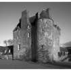
Dunderave Castle


Castle (16th Century)
Site Name Dunderave Castle
Classification Castle (16th Century)
Alternative Name(s) Dunderawe; Dunderamh; Dundarawe; Dundaramh
Canmore ID 23604
Site Number NN10NW 1
NGR NN 14323 09648
Datum OSGB36 - NGR
Permalink http://canmore.org.uk/site/23604


First 100 images shown. See the Collections panel (below) for a link to all digital images.
- Council Argyll And Bute
- Parish Lochgoilhead And Kilmorich
- Former Region Strathclyde
- Former District Argyll And Bute
- Former County Argyll
NN10NW 1 NN 14323 09648.
Also See
NN10NW 11 NN 1439 0969 Summerhouse
(NN 1432 0966) Castle (NR) (Ruins of)
OS 6" map, Argyllshire, 2nd ed., (1900)
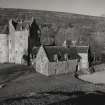
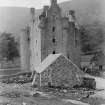
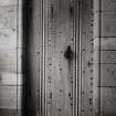
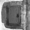
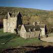
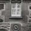
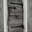
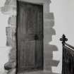
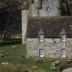
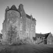
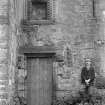
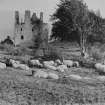
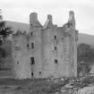
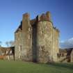
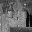
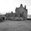
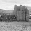
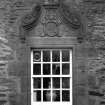
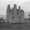
Dunderave Castle, built in 1596 and the chief seat of the Clan MacNachtan, until it was acquired by the Campbells about 1689. It has been an L-plan, crow-stepped tower house with a large round tower at the exterior angle.
The castle lay in ruins until the beginning of the 20th century when it was restored, with the addition of wings to the E and S gables. It is now occupied by Hon Mrs John Weir.
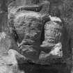
Charters dating from the 15th century suggest that the 16th century castle may have had a predecessor, which may possibly have stood on a rocky mound which has the appearance of a fortified site and lies between the tower and the loch into which it projects. The meaning of the name "Dunderave" is obscure, but Millar suggests that it could mean "the mound (or fort) with water on either side" - an apt description of the mound.
D MacGibbon and T Ross 1887-92; H B Millar 1964.
Dunderave Castle is as described. Although the rocky mound to the S is an ideal site for an earlier castle, it bears no evidence of having been used for such a purpose.
Visited by OS (R D) 7 May 1970.
OWNER: Noble
OCCUPIER: The Hon. Mrs John Weir
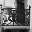
Built 1598. Restoration and additions by Sir Robert Lorimer, 1911-1912.
REFERENCE:
NATIONAL LIBRARY
Country Life, July 15th 1939 - article and photograph
Country Life, July 27th 1945 - photograph of model
NMRS SPECIAL COLLECTIONS: NMRS/MSS/LOR/73/49
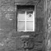
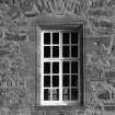
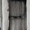
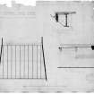
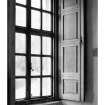
Dunderave: Windows
2 pages of rough notes and specifications of windows at Dunderave. 1 letter addressed to Sir Robert Lorimer from D.G. Findlay at Ardkinglas, dated 7th June 1912, sending 'plan of garage and old site of doors'; was pinned together with the above 2 pages.
PLANS:
NMRS I. G. Lindsay Collection, W/466
Field Visit (September 1988)
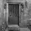
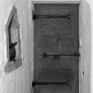
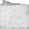
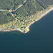
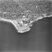
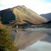
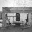
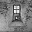
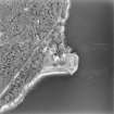
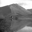
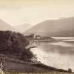
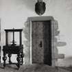
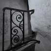
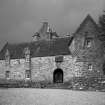
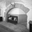
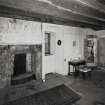
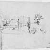
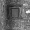
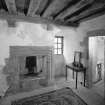
This substantial late 16th-century tower-house stands on Dunderave Point, a low promontory at the foot of a steep wooded hill-slope on the NW shore of Loch Fyne, about 5.8km from the head of the loch and 3km W of Ardkinglas (Nos. 110, 149) on the opposite shore. The headland immediately S of the tower rises to a rocky knoll which bears no visible structural remains, but on the shore to the E there are a boat-landing and slipways. The original building is an L-plan tower of four main storeys and a garret, erected by John MacNaughton in 1598, which remained in occupation, with minor alterations and additions, until the early 19th century. By the middle of that century it had become a roofless shell, but in 1911-12 it was restored and extended for the family of Sir Andrew Noble of Ardkinglas by (Sir) Robert Lorimer, architect (en.1).
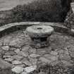
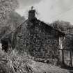
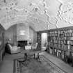
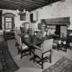
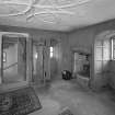
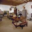
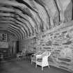
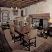
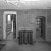
These early 20th-century additions, which were designed to harmonise with the tower, consist principally of 1 ½ -storeyed ranges enclosing the N and S angles of a cobbled and paved courtyard which is bounded on the W by the tower itself and on the E by the approach to a terraced garden. The SW range, occupying the site of a single-storeyed gabled cottage, now consists of a service basement with a colonnaded loggia above. The S range comprises a music room and rope room on either side of a pend, and a library on the first floor. The L-plan layout of the NW and NE ranges contains the kitchen, services and servants' rooms. Gardens and a garden cottage were laid out in the area to the E of the castle, and the policies include a former boat-house (NN143098) and a cottage (NN 137098), formerly thatched and still retaining pronounced slab skews.
RCAHMS 1992, visited September 1988
[A full architectural description and historical note is provided in RCAHMS 1992, 264-273)
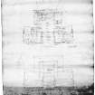
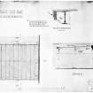
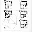
Measured Survey (September 1988)
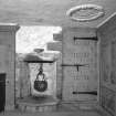
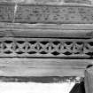
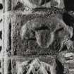
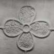
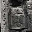
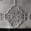
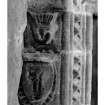
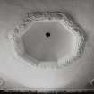
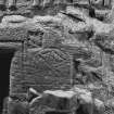
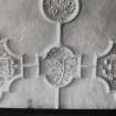
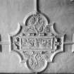
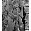
RCAHMS surveyed six moulding profiles at Dunderave Castle in September 1988 at a scale of 1:2. The profiles were redrawn in ink and published at a scale of 1:10 (RCAHMS 1992, 269H).
Measured Survey (23 September 1988)
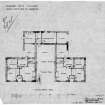
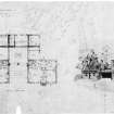
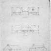
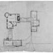
RCAHMS surveyed Dunderave Castle on 23 September 1988 with plane-table and alidade producing plans of the ground-, first-, second-, third- and fourth-floor at a scale of 1:100. The plans were redrawn in ink and published at a scale of 1:250 (RCAHMS 1992, 266).
Project (2009 - 2011)
Cairndow is a Highland village at the head of Loch Fyne in Argyll. The are of the parish is some 15,000 hectares . The resident population is about 200 but over 200 people work here.
Here We Are is a community initiative to develop and sustain Cairndow as a cohesive community for the benefit of residents, workers and visitors.
Cairndow village - the parish of Kilmorich - in Argyll, stretches from The Rest and Be Thankful pass down to, and then around the head of Loch Fyne on the road to Inveraray.
From 1900 until the 1960’s most of the land and the dwelling houses belonged to one landowner – Ardkinglas estate. By 2000 there were several landowners and most of the houses are now privately owned. Some families have been here for generations, others arrived only recently: thus it is a good example of a Highland village, representing continuity and change.
OUR HOUSES: THEIR STORIES is a biography of the 107 houses and of those who lived – and live – in them, their livelihoods and their occupations.
The first thing we did was photograph the houses. Then people began to give us and to send photos. The collection grew and we realised we have a gallery of people who had lived in the houses. From this the idea of “Our Houses: Their Stories” emerged.
Alice Beattie, Cairndow born and bred, listed who lived in which house from the 1841 census onwards. Every house and everybody who lived here was given a unique number.
With advice from Scottish Studies at Edinburgh University we recorded Nigel Callander and John MacDonald. Together, the two have rebuilt and renovated our buildings for over half a century.
Architects and Archaeologists from Simpson & Brown of Edinburgh have assessed building phases and architectural detailing of 60 of our houses.
Information from:
http://www.ourhousestheirstories.com/

