Accessibility

Font Size

100% 150% 200%

Background Colour

Default Contrast
Close Reset

Inverness, Kessock Bridge

Road Bridge (Period Unassigned)

Site Name Inverness, Kessock Bridge

Classification Road Bridge (Period Unassigned)

Alternative Name(s) Beauly Firth; Longman Point; Craigton Point

Canmore ID 68591

Site Number NH64NE 153

NGR NH 66514 47614

Datum OSGB36 - NGR

Permalink http://canmore.org.uk/site/68591

Ordnance Survey licence number AC0000807262. All rights reserved.
Canmore Disclaimer. © Bluesky International Limited 2025. Public Sector Viewing Terms

Toggle Aerial | View on large map

Digital Images

General oblique aerial view of the town centred on Inverness High School with Kessock Bridge in the distance and the park and the cemetery in the foreground, taken from the SW.
General oblique aerial view of the town centred on Inverness High School with Kessock Bridge in the distance and the park and the cemetery in the foreground, taken from the SW.Oblique aerial view.Aerial view of Caledonian Canal Sea Lock, Inverness, looking N.Aerial view of  mouth of the River Ness at Inverness, looking SE.Aerial view of mouth of the River Ness, Inverness, looking N.Aerial view of Kessock Bridge, Inverness, looking NE.Aerial view of Inverness, looking N.Aerial view of Inverness, looking NE.Aerial view of the west side of Inverness, looking N.Aerial view of North Kessock and Kessock Bridge, Inverness, looking ESE.Aerial view of mouth of Caledonian Canal and River Ness with Kessock Bridge, Inverness, looking ESE.Aerial view of mouth of the River Ness and the Kessock Bridge, Inverness, looking NE.Aerial view of the Kessock Bridge, Inverness, looking SSE.Aerial view of Inverness, looking N.Oblique aerial view centred on the road bridge, taken from the SE.Oblique aerial view centred on Kessock Bridge, taken from the NW.General oblique aerial view of Loch Duntelchaig, Inverness, the Kessock Bridge and Beauly Firth, looking NNE.Oblique aerial view of the Kessock Bridge, Inverness, looking SW.Aerial view of brigdeAerial viewGeneral oblique aerial view looking across the Caledonian Canal and Inverness towards the road bridge and the Moray Firth, taken from the S.Aerial view of Inverness and the Kessock Bridge, looking NE.Aerial view of Inverness, looking N.Aerial view of Inverness, looking NW.Aerial view of Beauly Firth and Moray Firth, looking NE.Aerial view of Longman & South Kessock, Inverness, looking, NE.Aerial view of Inverness, looking NE.Oblique aerial view of the Longman, South Kessock & Merkinch and Clachnaharry, Inverness, looking W.Aerial view of the Moray Firth, Kessok Bridge and Loch Ness, looking SW.Oblique aerial view centred on the road bridge, taken from the W.Oblique aerial view of the Citadel area of Inverness and the Longman Industrial Estate with Loch Ness beyond, taken from the NE.General oblique aerial view of Inverness with the Beauly Firth and Kessock Bridge beyond, looking to the NNW.General oblique aerial view of the Kessock Bridge, Inverness, with the Beauly Firth beyond, looking SW.Oblique aerial view.Oblique aerial viewAerial view of bridgeGeneral oblique aerial view looking across the Caledonian Canal and Inverness towards the road bridge and the Moray Firth, taken from the SW.General oblique aerial view looking across the Caledonian Canal and Inverness towards the road bridge and the Moray Firth, taken from the SSW.An oblique aerial view of Inverness, looking NE.Aerial view of Kessock Bridge, looking NW.Aerial view of Raigmore Hospital, Inverness, looking NW. Aerial view of Merkinch and South Kessock, Inverness, looking NE.Aerial view of the E end of the Beauly Firth at Inverness, looking E.Aerial view of the Moray Firth, Kessock Bridge and Loch Ness, looking S.Aerial view of Charleston/North Kessock, Kessock Bridge and Inverness, looking SE.Oblique aerial viewKessock Bridge.
Aerial view of bridge.General oblique aerial view centred on Inverness and the Kessock Bridge under construction, looking to the NNE.General oblique aerial view of the town centred on the school with the road bridge in the distance and the park and the cemetery in the foreground, taken from the SW.Oblique aerial view centred on the road bridge, taken from the S.Oblique aerial view of the Kessock Bridge, the Citadel area of Inverness and the Longman Industrial Estate with Loch Ness beyond, taken from the NE.General oblique aerial view of the Kessock Bridge, taken from the SW.General oblique aerial view of the Beauly Firth with the Kessock Bridge in the distance, looking to the ENE.Oblique aerial view of the Kessock Bridge, looking to the ENE.Oblique aerial view of the Kessock Bridge, looking to the NE.Oblique aerial view of the Caledonian Canal at Clachnaharry with the Kessock Bridge beyond, looking to the NE.General oblique aerial view of the Kessock Bridge, Caledonian Stadium and Longman Industrial Estate, Inverness, looking NW.General oblique aerial view of the Kessock Bridge,  Longman Industrial Estate and Beauly Firth, looking WNW.Aerial viewAerial view of The Kessock Bridge and the mouth of the River Ness, Inverness, looking NE.Aerial view of Inverness, looking NE.Oblique aerial view of the centre of Inverness, looking N.Aerial view of Lifeboat Day at North Kessock, Black Isle, looking NE.Aerial view of the Kessock Bridge, Inverness, looking SE.Aerial view of Inverness and the Moray Firth, looking NE.Oblique aerial view centred on Kessock Bridge, taken from the NE.General oblique aerial view of the Beauly Firth with the Kessock Bridge in the distance, looking to the ENE.General oblique aerial view of Inverness with the Beauly Firth and Kessock Bridge beyond, looking to the N.General oblique aerial view of the Kessock Bridge and Caledonian Stadium Football Ground, looking NW.Kessock Bridge.
Aerial view of bridge.Aerial viewAerial viewAerial view of Kessock Bridge, Inverness, looking E.Aerial view of Longman Industrial Estate, Inverness, looking NW.Aerial view of South Kessock and Merkinch, Inverness, looking E.Aerial view of Inverness, looking SW.Aerial view of the Kessock Bridge and Inverness Harbour, looking NE.Oblique aerial photograph of Kessock Bridge, Inverness, taken from the SW.Aerial view of Muirtown Locks and Basin, Caledonian Canal, Inverness, looking NE.Oblique aerial view of the Kessock Bridge, Inverness, looking W.An oblique aerial view of North Kessock and the Kessock Bridge, N of Inverness, looking NE.Oblique aerial View of the Longman Industrial Estate and Kessock Bridge, Inverness, looking NW.General oblique aerial view centred on Inverness and the Kessock Bridge under construction, looking to the NW.General oblique aerial view of Inverness with the Beauly Firth and Kessock Bridge beyond, looking to the NNW.General oblique aerial view of the Beauly Firth, Inverness and the  Kessock Bridge, looking SW.General oblique aerial view of the Kessock Bridge and Caledonian Stadium Football Ground, looking NW.Aerial view of bridgeAerial view of North Kessock and Charleston, Black Isle, looking NE.Aerial view of Kessock Bridge, Inverness, looking NE.Aerial view of Inverness, looking N.An oblique aerial view of Kessock Bridge, Inverness,, looking NNE.Aerial view of Inverness burgh and River Ness.Oblique aerial view of the northern section of Inverness, looking W.Oblique general distant aerial view of the Beauly Firth and Kessock Bridge, looking E.Oblique aerial view of Craig Dunain Hospital Building with Inverness and the Kessock Bridge, looking NE.General oblique aerial view of North Kessock on the Black Isle, and Inverness, looking S.Aerial view of The Aird and Beauly Firth, looking E.Distant aerial view of Inverness and the Kessock Bridge, looking NW.General oblique aerial view centred on Kessock Bridge and the harbour, taken from the SW.General oblique aerial view of Inverness with the Beauly Firth and Kessock Bridge beyond, looking to the N.

First 100 images shown. See the Collections panel (below) for a link to all digital images.

Administrative Areas

  • Council Highland
  • Parish Inverness And Bona
  • Former Region Highland
  • Former District Inverness
  • Former County Inverness-shire

Archaeology Notes

NH64NE 153 66514 47614

Kessock Bridge [NAT]

OS 1:10,000 map, 1992.

Location formerly entered as NH 6614 4792 to NH 6688 4729.

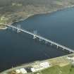
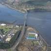
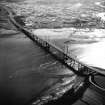
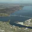
Built 1976-82 by the Cleveland RDL Kessock Consortium in association with Helmut Homberg and Trafalgar House Engineering Services Ltd.

J Gifford 1992.

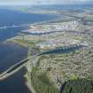
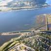
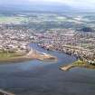
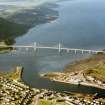
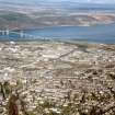
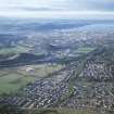
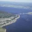
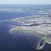
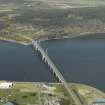
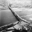
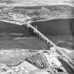
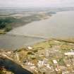
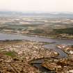
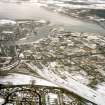
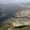
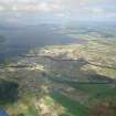
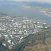
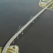
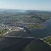
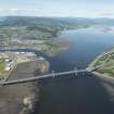
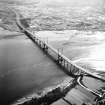
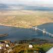
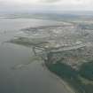
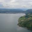
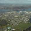
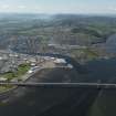
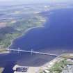
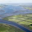
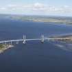
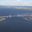
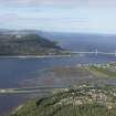
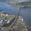
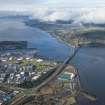
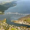
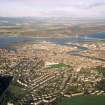
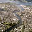
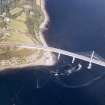
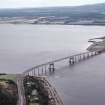
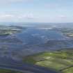
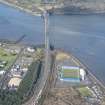
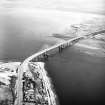
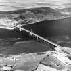
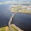
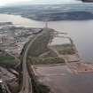
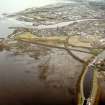
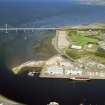
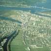
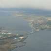
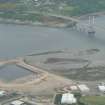
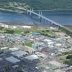
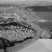
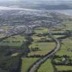
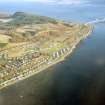
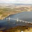
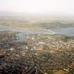
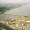
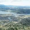
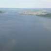
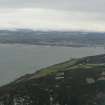
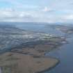
This bridge carries the A9(T) dual-carriageway public road over the Beauly Firth at the Kessock Narrows, between Longman Point, South Kessock (Inverness-shire) and Craigton Point, North Kessock (Ross and Cromarty). It was built in conjunction with the Cromarty Bridge (NH56SE 37) across the Cromarty Firth, and is approached up a rising road on the S side and across the level clifftop on the N.

Information from RCAHMS (RJCM), 22 July 1997.

Bridge - observed.

20th century AD; built 1976-82.

CFA/MORA Coastal Assessment Survey 1998.

The location assigned to this record defines the midpoint of the structure. The available map evidence indicates that it extends from NH c. 66896 47282 to NH c. 66092 47935.

Information from RCAHMS (RJCM), 29 March 2006.

Activities

Publication Account (2007)

(Institute Civil Engineers Historic Engineering Works no. HEW 2536)

Kessock Bridge

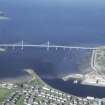
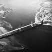
Kessock Bridge carries the A9 trunk road over the Beauly Firth between Inverness and the Black Isle replacing the former ferry. When built from 1978–82 it was the largest cable-stayed bridge in Europe and the only one of its type in Britain. Its design is said to have been modelled on the Rees Bridge over the Rhine near Dusseldorf.

The navigation span is 787 ft and is supported by groups of eight spiral-strand steel cables up to 3934 in. diameter in a harp arrangement. The steel superstructure is fully continuous over the supports and the open cross-section comprises 1112 ft deep plate girders supporting an orthotropic steel deck. The tender sum was £17.24 million.

An unusual feature of the design is the need to accommodate possible movement on the Great Glen fault at the north abutment. This is achieved by means of two 394 ton hydraulic buffers.

The bridge was designed for the Scottish Development Dept by Dr Helmut Homberg in association with Cleveland Bridge & Engineering who were also the steel contractors. The consulting engineers were Crouch & Hogg and Ove Arup. The foundations and reinforced concrete work were

executed by RDL Contracting Ltd.

R Paxton and J Shipway, 2007.

Reproduced from 'Civil Engineering heritage: Scotland - Highlands and Islands' with kind permission from Thomas Telford Publishers.

References

MyCanmore Image Contributions


Contribute an Image

MyCanmore Text Contributions