
Pricing Change
New pricing for orders of material from this site will come into place shortly. Charges for supply of digital images, digitisation on demand, prints and licensing will be altered.
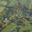
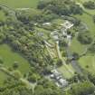
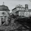
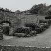
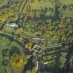
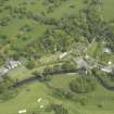
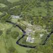
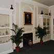
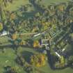
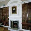
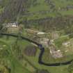
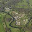
Glasgow, Pollokshaws Road, Pollok Park, Pollok House, Walled Garden


Walled Garden (18th Century) - (20th Century), War Memorial (20th Century)
Site Name Glasgow, Pollokshaws Road, Pollok Park, Pollok House, Walled Garden
Classification Walled Garden (18th Century) - (20th Century), War Memorial (20th Century)
Alternative Name(s) Pleasure Gardens; War Memorial
Canmore ID 78303
Site Number NS56SW 31.01
NGR NS 55048 61753
Datum OSGB36 - NGR
Permalink http://canmore.org.uk/site/78303


First 100 images shown. See the Collections panel (below) for a link to all digital images.
- Council Glasgow, City Of
- Parish Eastwood (City Of Glasgow)
- Former Region Strathclyde
- Former District City Of Glasgow
- Former County Lanarkshire
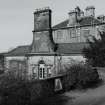
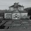
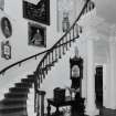
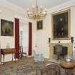
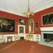
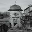
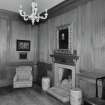
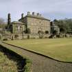
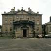
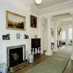
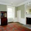
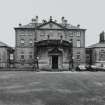
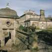
Lodge, Pollok House, 97 Haggs Road, 1892, R Rowand Anderson. Scottish classical with shallow conical slate roof over a broad semicircular bay window. Shawmuir Lodge, Pollok Avenue, 2060 Pollokshaws Road, 1891, Robert Rowand Anderson. Scots Classical Lodge with bell-cast slate hipped roof. Tall square gatepiers with urns and decorative wrought-iron gates. Estate Bridge over River Cart, 1757. Single wide segmental arch, balustraded parapet, roadway widens at abutments. Stables Range, 17th to 19th century. Courtyard Range on site of previous house, the Laigh Castle, includes handsome Renaissance gateway (north-west side) and more 17th-century work incorporated into later buildings. Weir, Sawmill and Power Station, c.1860 for Sir John Stirling-Maxwell. Weir may be 18th century. Single-storey brick sawmill with early machinery, although a turbine replaces the low-breast water wheel. Late 19th-century Power Station, with Waverley turbine by Carrick & Ritchie of Edinburgh.
Taken from "Greater Glasgow: An Illustrated Architectural Guide", by Sam Small, 2008. Published by the Rutland Press http://www.rias.org.uk

NS56SW 31.01 55048 61753
NS 550 615 In June 1995, GUARD was commissioned to conduct a watching brief on bore holing activity near Pollok House in the Pollock Estate, Glasgow. This work formed part of a wider test-pitting programme designed to assess the stability and constitution of the local geological deposits, ahead of the proposed construction of flood defences against the nearby White Cart. It was recognised that the location of the work, within a designed landscape of historical importance, and specifically its proximity to the old courtyard, rendered the presence of significant archaeological remains a distinct possibility.
Four test pits were dug by machine, whilst four small samples were taken by hand bores. The pits and bore holes were characterised by the presence of a loamy topsoil and orangey clay deposits on top of riverine sands and gravels. No archaeological features were encountered.
Sponsor: Glasgow District Council.
R James 1995.
Project (25 February 2008 - 26 February 2008)
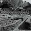
NS 551 616 The purpose of this survey was to ascertain if there were any remains of the earlier medieval settlement associated with the stable block (NS56SW 31.3) in the paddock to the E of this site. The survey used geophysical (magnetometry/resistivity techniques) and topographic survey. The survey area is now used as a paddock, 83 x 35.5m at its widest points, and is on the southern edge of NS56SW 31.1. The site is defined by a wall to the N, iron five-bar fencing to the W and E and to the S it runs to the lade associated with the sawmill (NS56SW 31.4).
A grid system was designed around a 20 x 20m layout, where achievable, and was positioned 1m S of the perimeter wall at the N of the site. Both geophysical techniques were used including the use of a multiplexer frame for the resistivity, over the course of the two days (25–26 February 2008). The data retrieved clearly showed the remains of the pathways associated with the site when it had been planted as an orchard. A rectilinear feature was also discovered against the wall in the northern part of the site. These remains were only recovered when the multiplexer was deployed and the depth of penetration was c1.5m. This may indicate that the site has been heavily landscaped since it was turned over to pasture, as no features or anomalies associated with the tree planting, such as tree bowls, were recorded in the orchard. There is no indication of any remains other than those mentioned, which appear to be associated with 19th-century agricultural and horticultural activity.
Archive: RCAHMS (intended)
Funder: Glasgow Archaeological Society
Mark Mitchell and Stephen Driscoll – Glasgow Archaeological Society
Earth Resistance Survey (25 February 2008 - 26 February 2008)
NS 551 616 Resistivity survey.
Archive: RCAHMS (intended)
Funder: Glasgow Archaeological Society
Mark Mitchell and Stephen Driscoll – Glasgow Archaeological Society
Magnetometry (25 February 2008 - 26 February 2008)
NS 551 616 Magnetometry survey.
Archive: RCAHMS (intended)
Funder: Glasgow Archaeological Society
Mark Mitchell and Stephen Driscoll – Glasgow Archaeological Society

