
Kilbrannan Chapel


Burial Ground (Medieval), Chapel (14th Century)
Site Name Kilbrannan Chapel
Classification Burial Ground (Medieval), Chapel (14th Century)
Alternative Name(s) St Brendan's Chapel; Skipness Chapel
Canmore ID 39799
Site Number NR95NW 6
NGR NR 91037 57526
Datum OSGB36 - NGR
Permalink http://canmore.org.uk/site/39799


First 100 images shown. See the Collections panel (below) for a link to all digital images.
- Council Argyll And Bute
- Parish Saddell And Skipness
- Former Region Strathclyde
- Former District Argyll And Bute
- Former County Argyll
NR95NW 6 91037 57526.
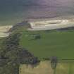
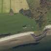
(NR 9100 5752) Kilbrannan Chapel (NR) (In Ruins)
OS 6" map (1924)
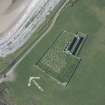
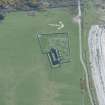
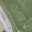
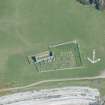
Kilbrannan Chapel, which is of late 13th or early 14th century date, is an oblong single-chambered building 25.1m E-W by 8.2m over walls varying from 1.14m to 1.37m thick. It was presumably erected to replace the earlier chapel of St Columba, whose remains are incorporated with Skipness Castle (NR95NW 5). The dedication is to St Brendan. The building appears to have remained in use until at least 1692, and was probably abandoned for worship some time in the 18th century, perhaps as a consequence of the erection of a church at Claonaig.
Five late medieval recumbent tombstones are visible within the chapel, or in the surrounding graveyard, along with a number of pre-Reformation slabs.
RCAHMS 1971, visited 1965
As described. The burial grounds attached to the chapel are still in use.
Visited by OS (IA) 9 August 1973
NR 9103 5753. As described in the previous information.
Surveyed at 1:10,000.
Visited by OS (TRG) 22 February 1977
An extensive geophysical survey was carried out here in 1993. Three trenches were also dug in an area to the NE of the chapel, in advance of a proposed graveyard extension. At least two graves were found, near the chapel, which predate the present graveyard enclosures.
G Ewart 1993.
NR 9103 5752 Site identified as part of a coastal zone assessment survey.
M Cressey and S Badger 2005.
This site has only been partially upgraded for SCRAN. For further information, please consult the Architecture Catalogues for Argyll and Bute District..
February 1998
Publication Account (1985)
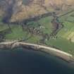
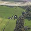
The magnificent castle of Skipness has a sequence of construction from the first half of the 13th century until it was abandoned at the end of the 17th century. It was first mentioned in 1261 when it was held by Dugald, son of Sween, presumably on behalf of the MacDonald chiefs; it remained in MacDonald hands until 1493 with the final forfeiture of John, Lord of the Isles, and subsequently was granted to the 2nd Earl of Argyll. The two earliest parts of the castle, a hall-house and separate chapel, were incorporated within the curtain wall of a castle of enceinte in the late 13th or early 14th century, the hall-house at the north-west corner and the chapel forming part of the inner wall on the south. The walls of the great courtyard castle survive almost to their original height with a complex gatehouse on the south wall which has a portcullis chamber above iti on the west wall there is a projecting latrine tower. The building of the three upper floors at the north-east corner of the castle are of rather later date probably at the beginning of the 16th century.
The chapel, dedicated to St Brendan, is situated 320m south-east of the castlei it dates from the same periodearly 14th century, at which time an earlier chapel was incorporated within the castle itself and its ecclesiastical use forgotten. The new chapel is a long building with the nave at the west end and the chancel to the easti the side-walls and gables survive almost intact The window- and door-mouldings are almost complete and, though plain or with simple decoration are described as of Anglo-Scottish First Pointed style.
Information from ‘Exploring Scotland’s Heritage: Argyll and the Western Isles’, (1985).
Excavation (12 September 1992 - 11 November 1992)
An extensive geophysical survey was completed on this site, intended to characterise the main structural sequence in advance of development.
A total of four areas were subsequently excavated in the light of the geophysical survey and demonstrated that:
1. The castle sits on an artifically extended natural gravel terrace - one of a series of raised beach deposits.
2. The present contours and limits of the castle mound have been extensively reworked as part of the policies of the neighbouring Skipness House.
3. There was evidence that the castle mound was extended and complemented by a shallow ditch, probably reflecting the general refurbishment of the site in the later 13th century.
4. 19th and 20th century occupation of the tower house saw the almost total clearance of redundant courtyard structures.
5. Robbed wall lines were traceable in the form of foundation pads rather than trenches, cut against the bedding for a cobbled surface in the courtyard.
6. The main cause of the present flooding on the site appeared to be the use of rolled turf as a courtyard surface, and a possibly ruptured water main located to the N of the castle.
G Ewart 1993
Sponsor: Historic Scotland
Kirkdale Archaeology

