
Cromarty, General


Burgh (Medieval), Town (Medieval)
Site Name Cromarty, General
Classification Burgh (Medieval), Town (Medieval)
Canmore ID 14479
Site Number NH76NE 54
NGR NH 7875 6756
NGR Description Centred NH 7875 6756
Datum OSGB36 - NGR
Permalink http://canmore.org.uk/site/14479


- Council Highland
- Parish Cromarty
- Former Region Highland
- Former District Ross And Cromarty
- Former County Ross And Cromarty
BIBLIOGRAPHIC REFERENCES: NMRS LIBRARY
Country Life, August 11th 1977
Scotland's Magazine, September 1962 p.39
Photographic Survey (1961)
Photographs of buildings in Cromarty, Ross and Cromarty, by the Scottish National Buildings Record in 1961.
Note (1979)
Cromarty NH 787 676 NH76NE
Cromarty had attained burgh status by 1266 but received a charter as a royal burgh in 1593 and ranked as a burgh of barony from 1681.
RCAHMS 1979
Pryde 1965, 19, no. 36
Publication Account (1995)
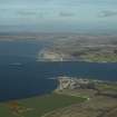
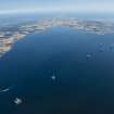
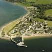
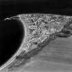
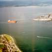
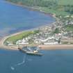
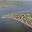
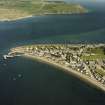
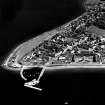
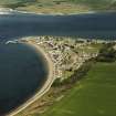
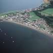
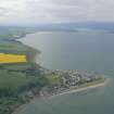
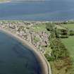
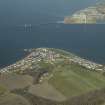
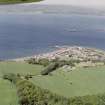
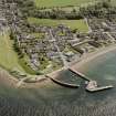
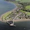
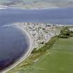
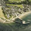
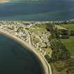
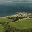
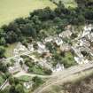
Cromarty, which was a Royal Burgh from before 1264 to 1685, is now a unique example of a small late 18th-century burgh wh ich has largely escaped later development. It stands at the mouth of the Cromarty Firth, a magnificent natural harbour, and was formerly on the main route north from Inverness, which ran along the coast, linked by ferries across the firths.
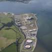
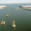
The development of Cromarty as we see it today was due to Sir George Ross, who bought it in 1765. He built the present harbour to encourage fishing, and established various industries such as the hempworks and a brewery, all of which enterprises were successful for some considerable time. However, in the mid-19th century, the fishing failed, the railway arrived on the other side of the firth, and Cromarty declined. In recent times it has become a conservation area and old buildings are being restored, while oil-related industries once more provide employment.
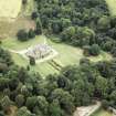
Little is left of 17th-century Cromarty. The old castle, a fine tower-house, was demolished when George Ross built Cromarty House nearby in 1772.This elegant Georgian house, not visible from the road, is somewhat similar to the main block of Culloden House (no. 37). Its contemporary stables can be seen opposite the Old St Regulus burial ground in The causeway. In the same road is the earliest surviving house in Cromarty, dating from around 1690; once the manse for the East Kirk, it is irregular in plan with high steep roofs. In Church Street is the East Kirk, the old parish church, of which the main east-west block may date to about 1690, but a north aisle and loft were added in 1738-40, making it a typical T-plan church. Various alterations in the late 18th century included raising the walls and adding two more lofts, one the laird 's loft with its panelled front and carved cornice supported on classical columns, but little alteration has occurred in the interior since then. Most of the pews in the lofts are old, though some have been rearranged; the carved and painted pew in the north loft, opposite the pulpit, was probably once the laird 's pew and has a coat-of-arms of the Mackenzies, lairds in the earlier 18th century. The bench pews in the body of the church are mostly Victorian, but some, such as the rearranged table pews, are earlier. Note the wooden bonnet pegs by the door under the laird 's loft. The pulpit against the south wall was made in 1907 but is in keeping.
Also in Church Street is "Hugh Miller's Cottage, NTS, white-harled with crowstepped gables and tiny windows under a thatched roof. It shows how many of the other 18th-century cottages once looked. Hugh Miller was a local stonemason who became famous as a geologist, writer and lay leader of the Free Church. The cottage was built in 1711 by his great-grandfather, John Feddes, a sea captain, and is a substantial dwelling with six rooms. The central toom was the original kitchen and has a 'hanging-lum' or chimney canopy made of wood and daub, used for smoking fish. Part of the plaster has been stripped from a wall to show the internal fabric, a mixture of rubble, clay and straw. Through a low door is the best room or parlour, with a proper fireplace and a marriage lintel over it dated 1711, now appropriately furnished, while upstairs is a display about the life and work of Hugh Miller. The house next door was built by Hugh's father in the early 19th century, and lived in by Hugh after his marriage. Up the hill is a memorial to Hugh Miller erected in 1859, and the Gaelic chapel, now roofless, built by George Ross in 1783 for Gaelic speakers who had moved into Ctomarty from the Highlands.
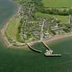
The elegant Court House with a dome (originally leaded) to its belfry tower and a clock by John Ross of Tain was built by George Ross in 1773. Inside,the first-Eloor court room retains 19th-century seating, witness box and cast-iron stoves. Behind is the prison block with three cells, one being a dayroom with fireplace (origina lly the debtor's prison), and an exercise gallery built in 1845 by Thomas Brown, who also built the jails at Dornoch (no. 60) and Inverness (no. 1). The rest of the ground floor, one room of which was formerly a cell, was altered at the same time to provide accommodation for the jailer. There is an interesting ducted-air heating and ventilating system run from a stove in the corridor to try to combat damp. The Court House now houses an imaginative display with animated figures featuring Sir Thomas Urguhart, the eccentric 17th-century laird of Cromarty, and a 19th-century trial reenacted in the courtroom. Open all year round.
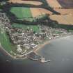
There is a striking contrast between the houses in Fishertown, stretching west from Church Street to the sea, with small often single-storey cottages, harled and originally thatched, and the more substantial houses in other parts, stone-faced and slated. Many of these have 'cherry-pointing', tiny pieces of stone set in the mortar which helped level uneven blocks. 'An ugly fashion' wrote Southey. 'A dark slate is preferred from a vile fancy that this regular dotting improves the appearance of the building'. Happily the dotting is less obtrusive since the buildings have weathered. Of the larger merchants' houses, Bellevue and St Anne's in Church Street were built around 1800, and Forsyth House in High Street in the late 18th century.
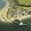
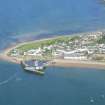
The brewery built by George Ross stands in Burnside Place, a rectangular three-storey building with a hoist from a dormer window. Returning through Fishertown to the harbour, there is a datestone on no. 7 Braehead carved with a tailor's flatiron, scissors and the date 1727; below Braehead on the links is the mid-19th-century vaulted and turf-covered icehouse, now used as a store by fishermen. Further along is the smartly painted lighthouse, built by Alan Stevenson in 1846, with Egyptian-style doors to the lighthouse tower and adjoining keepers' cottages. Next comes the harbour, with its two piers built at the joint expense of the government and George Ross in 1785, and round the corner in Marine Terrace is another of his projects, the Old Linenworks and Ropeworks of around 1783, now converted into houses. Originally built round four sides of a yard, part has been pulled down leaving three long red sandstone ranges. The immensely long east range (and the missing west range) will have been needed for the ropewalks. There is a dwelling house in the middle of the south wing. In 1794 hempen cloth manufacture was carried on here by a company of London merchants: 'The fabrics, which are chiefly designed for cotton and coal-bagging, are in general for exportation. Within the walls are about 200 people employed-men, women and children'. Others span in their own homes. The works shut down in 1850.
Guide-books to the East Church and to Cromarty and tape tours of Cromarty are available from the Court House.
Information from ‘Exploring Scotland’s Heritage: The Highlands’, (1995).
Photographic Survey
Photographs of buildings in Cromarty, Ross and Cromarty, by the Scottish Nationa Buildings Record in 1957.

