
Following the launch of trove.scot in February 2025 we are now planning the retiral of some of our webservices. Canmore will be switched off on 24th June 2025. Information about the closure can be found on the HES website: Retiral of HES web services | Historic Environment Scotland
Craig Phadrig


Fort (Prehistoric) - (Early Medieval), Vitrified Stone (Prehistoric)
Site Name Craig Phadrig
Classification Fort (Prehistoric) - (Early Medieval), Vitrified Stone (Prehistoric)
Canmore ID 13486
Site Number NH64NW 6
NGR NH 64001 45280
NGR Description Centred NH 64001 45280
Datum OSGB36 - NGR
Permalink http://canmore.org.uk/site/13486


!['Sketch of Craig Patrick by Mr Watt Engineer. Extract from Williams, J 1777 'An Account of some remarkable ancient ruins lately discovered in the highlands and the northern parts of Scotland. [photographic copy only]](http://i.rcahms.gov.uk/canmore/l/SC01376598.jpg)


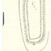


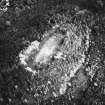
!['Sketch of Craig Patrick by Mr Watt Engineer. Extract from Williams, J 1777 'An Account of some remarkable ancient ruins lately discovered in the highlands and the northern parts of Scotland. [photographic copy only]](http://i.rcahms.gov.uk/canmore/s/SC01376598.jpg)


- Council Highland
- Parish Inverness And Bona
- Former Region Highland
- Former District Inverness
- Former County Inverness-shire
NH64NW 6 6400 4527.
NH 6400 4527) Vitrified Fort (NR)
OS 6"map, (1959)
(NH 6400 4529) Cistern (NR)
OS 25"map, (1964)
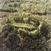
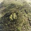
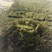
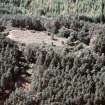
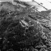
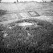
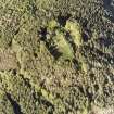
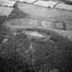
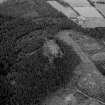
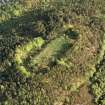
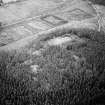
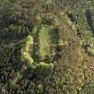
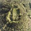
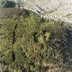
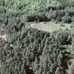
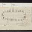
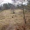
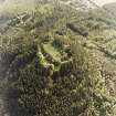
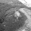
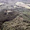
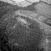
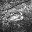
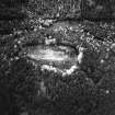
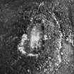
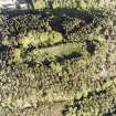
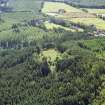
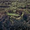
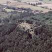
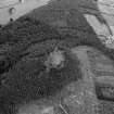
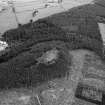
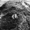
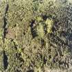
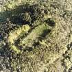
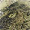
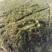
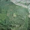
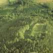
An oval vitrified fort, forming a flat crown to the afforested hill of Craig Phadrig.
It consists of an inner, heavily vitrified wall spread to a thickness of about 30', which encloses an area measuring 245' by 75'. An outer wall, also heavily vitrified, lies at distances varying between 45' and 75' outside this. Any other details are obscured by vegetation. (R W Feachem 1963) There is no evidence to show that the two walls are contemporary. (R W Feachem 1966)
Cotton (M B Cotton 1954) observed an entrance in the W of the outer wall, and traces of a third wall on the S side, also states that the inner wall may have had four bastion-like structures near the rounded corners.
According to Wallace (T Wallace 1921), there is a small earthen tumulus with a stone in its centre, within the fort, and a portion of the NE corner was marked off from the rest by two rows of earthfast stones in the form of a rectangle. He could not trace a well, said in 1783 (F Tytler 1783) to be 6' in diameter. This is the reputed scene of the visit of St Columba to Brude, son of Maelchon, king of the Picts, and the latter's conversion to Christianity. (information from C W Phillips' D A Index)
R W Feachem 1963, 1966; M B Cotton 1954; T Wallace 1921; F Tytler 1783; Adamnan 19 .
A vitrified fort, as described by Feacham (R W Feachem 1966). The inner turf-covered wall is well defined, surviving to c. 1.2m above the interior, with an entrance in the NE indicated by a slight depression. Immediately outside this entrance is a stony causeway which spans the gap between the two walls.
The outer wall is reduced to a terrace except in the SW and NE where it survives as a turf-covered stony bank c. 0.8m high. The entrance is not evident but it was probably in the E arc where there are two slight depressions in the bank. Cotton's alleged entrance (M A Cotton 1954) in the W is due to mutilation.
The third wall observed by Cotton (M A Cotton 1966) is a hornwork outside the E arc of the outer wall. It is defined by a reduced turf-covered stony bank which springs from the E corner of the wall and runs N to rejoin it opposite the entrance through the inner wall. There is an entrance gap near its S end up to which runs an ill-defined hollow way.
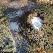
There is no trace of any structure within the fort except the alleged cistern which is a hollow c. 3.0m across at the lowest point within the central area, but there are several similar hollows around it.
Survey at 1/2500 (Visited by OS (W D J) 29 March 1962).
Visited by OS (A A) 25 August 1969.
Excavation by Small and Cotton during 1971 (A Small and M B Cotton 1972) has established the vitrified character of the inner rampart. Radio-carbon dates suggest the mid-4th cent. BC as the period of construction. Similar dates were obtained from the outer rampart which appears to be only in part timber-laced, several parts being entirely constructed of earth sometimes retained by revetting walls. A further season's excavation is essential before definite conclusions can be reached, however.
The fort appears to have been destroyed soon after construction. Post-destruction domestic occupation has been recorded before 150 BC and up to c. 400 A. D. The most important find is the clay mould for the escutcheon of a hanging bowl.
A Small and M B Cotton 1972; A Small 1972.
NH 640 452 An archaeological watching brief was carried out on 11 September 2006 at Craig Phadraig, Inverness, during construction of a footpath. No features or artefacts of archaeological significance were found.
Report lodged with Highland SMR and Library Service, and NMRS; archive will be deposited with RCAHMS.
Sponsor: Forestry Commission Scotland.
John Wood, 2006.
Field Visit (15 August 1943)
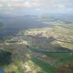
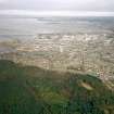
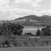
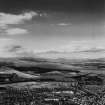
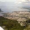
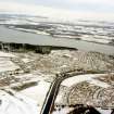
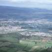
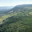
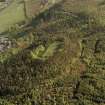
Craig Phadrig is an isolated peak of conglomerate rising to just under 800ft; it forms the north east extremity of the ridge between the Ness Valley and the Beauly Firth that is continued beyond the [track] by the Hill of Kessock. The sides of the peak are steep and in places precipitous. The elongated summit is defended by two stony ramparts entirely covered with grass and whins; the outer one was still planted with trees when the site was visited. The trees on the inner rampart and in the interior had been felled. The inner rampart encloses an irregular rectilinear figure, running from the south east dead straight for about 250’ and on the north west for 220’ but not quite parallel since the width at the north east end is 90’ from crest to crest [but] at the south west only 80’. No vitrified masses are now exposed, but on the south west the track across the rampart has laid bare two or three stones of a built masonry face 20’ outside the apparent crest of the rampart. No visible gap interrupts the rampart.
The outer rampart is much more overgrown. It crosses the ridge 63’ from the inner rampart’s crest at the north east end and 73’ from it at the south west end, but on the steep sides approaches to within 45’ of the inner rampart.
The interior of the enclosure is some 4’ below the rampart crest, but is uneven and pitted with hollows filled with nettles and ferns.
Visited by RCAHMS (VGC, AG) 15 August 1943.
Sources: Tytler 1783, Wallace 1921
[Typescript: INV 21; Manuscript (2): 1943, 105 (sketch]
Field Visit (20 July 1957)
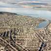
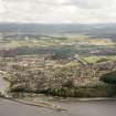
This fort is situated on an isolated, steep-sided peak of conglomerate which lies one and a half miles west of the centre of Inverness; it attains a height of 400 feet OD and forms the north east extremity of a ridge dividing the lower Ness valley from the Beauly Firth. The ridge continues north east of the Firth, rising at once to the summit known as Ord Hill of Kessock (qv Ross and Cromarty). The fort is sub-rectangular on plan and measures 245 feet in length from north east to south west by between 60 feet and 75 feet transversely within the substantial ruin of a stone wall spread to a thickness of up to 30 feet and standing to a height of about 4 feet above the interior. The whole of the wall is covered in woodland vegetation, brambles and scrub, and although it is reportedly to be solidly vitrified all round the only part actually seen on the date of visit was at a point near the north corner. The thickness of the wall cannot readily be judged, but the size of the ruin suggests that it might have been as much as 20 feet at base. Another, reputedly vitrified, wall lies at a distance varying, at the crest, from 45 feet to 75 feet outside the inner one. This wall runs through dense scrub, but as far as could be judged, it had spread to about 15 feet in width and stood about 3 foot in height. No entrance gaps could be located in either of the ramparts (cf Knock Farrel), and nothing recognisable occurs in the interior except a depression near the north east end of the interior of the inner work. This was recorded by Williams as having been a well which was substantially filled to prevent danger to sheep in the 18th century.
Visited by RCAHMS (RWF?) 20th July 1957.
Field Visit (February 1978)
Craig Phadrig NH 640 452 NH64NW 6
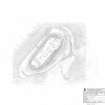
Situated in a commanding position overlooking the narrow mouth of the Beauly Firth, this fort consists of two heavily vitrified walls, up to 23m apart, the inner of which (1 .4m high and spread to a thickness of 9.2m) encloses an area measuring 75m by 23m; on the E there are the remains of what may have been an outer hornwork. Excavations in 1971 -2 showed that the walls were built probably during the fourth century BC and yielded evidence of occupation at some time during the Dark Ages.
RCAHMS 1979, visited February 1978
(Small and Cottam 1972; DES (1972), 23)
Publication Account (1995)
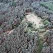
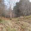
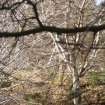
The fort occupies the summit of a prominent wooded hill. It has two more or less concentric ramparts enclosing a grass-grown subrectangular area some 80m long. The fort and its ramparts are clear of trees, and there are glimpses of the originally extensive views over Inverness and the Beauly Firth.
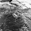
Excavation in 1971 showed that both ramparts had been constructed of timberlaced stonework and subsequently burnt, and contained large masses of vitrified material. The inner rampart is particularly massive, and good examples of vi trification can be seen under the roots of a pine tree at the north end. There is a steep slope down to the outer rampart which is a slighter affair. No original entrances can be identified. Radiocarbon dates from the ramparts suggest they were built in the 5th or 4th centuries BC.
A small excavation in the interior produced unexpected evidence for recoccupation of the fort in the 6th or 7th centuries AD. The finds included a few small scraps of imported pottery, and a clay mould for casting a metal fitting for a hangingbowl (in NMS, replica in Inverness Museum).There is some suggestion that the ramparts were refurbished at this time. An historical king of the Picts, Brideison of Maelchon who ruled around AD 555 to 584, had a royal house near the river Ness where he was visited by St Columba. The description would fit Craig Phadrig well, though other sites such as Inverness Castle Hill are also possible.
Information from ‘Exploring Scotland’s Heritage: The Highlands’, (1995).
Watching Brief (11 September 2006)
NH 640 452 An archaeological watching brief was carried out on 11 September 2006 at Craig Phadraig, Inverness, during construction of a footpath. No features or artefacts of archaeological significance were found.
Report lodged with Highland SMR and Library Service, and NMRS; archive will be deposited with RCAHMS.
Sponsor: Forestry Commission Scotland.
J Wood 2006
Ground Survey (27 September 2010 - 22 February 2011)
A topographic survey of five hillforts on Forestry Commission land was undertaken in September 2010, and completed in February 2011. The forts surveyed were: Caisteal Mac Tuathal, Kenmore (NN 7790 4765); Dun da Lamh, Laggan (NN 5823 9295); Dun Deardail, Fort William (NN 1270 7013); Tor Dhuin, Fort Augustus (NH 3485 0693) and Craig Phadrig, Inverness (NH 6400 4528). The survey aimed to produce plans at a scale of at least 1:1000. Two of the forts, Caisteal Mac Tuathal and Tor Dhuin are covered by dense bracken and its removal would significantly improve the appearance of these forts.
Archive: RCAHMS
Funder: Forestry Commission Scotland
Headland Archaeology Ltd, 2011
Information also reported in Oasis (headland1-95129) 4 August 2011
Project (July 2013 - December 2013)
NH 6400 4527 As part of the Northern Picts Project surveys and excavations have been undertaken in an area stretching from Aberdeenshire to Easter Ross targeting sites that can help contextualize the character of society in the early medieval period in northern Pictland. Two short seasons of geophysical survey in July and December 2013 were conducted on Craig Phadrig Fort where important Iron Age and early medieval phases to the vitrified fort have been identified.
During the July survey magnetometry was attempted on the interior of the fort, but the vitrification and geology rendered the results unusable. Survey shifted to resitivity and four 20 x 20m grids in July and eight further grids in December covered the interior and lower citadel of the fort. The survey grids were recorded with dGPS.
The survey has shown the potential for geophysical survey to reveal details on the internal layout of forts such as Craig Phadrig. Possible features identified included potential circular structures in the southern end of the upper citadel and activity areas in the lower citadels. The most intriguing features are two linear low resistance features with a bowed end (features 9 and 10 on interpretative plot). These features may be the
remains of an internal palisade or large structure within the northern end of the upper citadel. A possible entrance to this structure is on the northern end where the linear anomalies curve towards one another.
Archive: University of Aberdeen
Funder: University of Aberdeen Development Trust in partnership with the Tarbat Discovery Centre and Forestry Commission Scotland
Gordon Noble, Matt Ritchie and Oskar G Sveinbjarnarson – University of Aberdeen and Forestry Commission Scotland
(Source: DES)
Earth Resistance Survey (July 2013 - December 2013)
NH 6400 4527 Resistivity survey.
Archive: University of Aberdeen
Funder: University of Aberdeen Development Trust in partnership with the Tarbat Discovery Centre and Forestry Commission Scotland
Gordon Noble, Matt Ritchie and Oskar G Sveinbjarnarson – University of Aberdeen and Forestry Commission Scotland
(Source: DES)
Magnetometry (July 2013 - December 2013)
NH 6400 4527 Magnetometry survey.
Archive: University of Aberdeen
Funder: University of Aberdeen Development Trust in partnership with the Tarbat Discovery Centre and Forestry Commission Scotland
Gordon Noble, Matt Ritchie and Oskar G Sveinbjarnarson – University of Aberdeen and Forestry Commission Scotland
(Source: DES)
Measured Survey (September 2013)
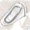
RCAHMS surveyed Craig Phadrig fort in September 2013, in partnership with Forestry Commission Scotland, producing a site plan at a scale of 1:500.
Ground Survey (6 February 2014)
NH 6400 4527 A detailed topographical survey of the surviving remains of a late prehistoric or early historic vitrified fort at Craig Phadrig was carried out on 6 February 2014. The survey allowed the creation of a digital terrain model, contour-based plans and oblique terrain models of the site within its landscape setting, which will be utilised to inform future conservation and management of the monument by Forestry Commission Scotland. It was one of a group of six such surveys carried out on Forestry Commission Scotland sites in February 2014. The other sites were at Castle Greg, Round Dounan, Sean Craig, Dun Deardail and Torr Dhuin.
Archive: RCAHMS
Funder: Forestry Commission Scotland
Louise Baker and Enda O’Flaherty – Rubicon Heritage Services Ltd
(Source: DES)
OASIS ID - rubiconh1-189842
Archaeological Evaluation (January 2015)
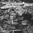
NH 6400 4527 In January 2015, severe winter storms caused significant damage to Craig Phadrig Hillfort after two windblown trees exposed a section of the inner rampart at the N end of the site. Prior to consolidation and reinstatement of the damaged area, a small archaeological evaluation was carried out, 9–18 February 2015, to assess the level of damage and record the nature of surviving archaeological deposits within the tree exposures. Clean-up of the exposed sections revealed considerable vitrified and heat-affected stone throughout the upper rampart. The tree root plates had significantly damaged the core of the upper rampart bank and the inner wall face of the main rampart.
The evaluation trench revealed that a palisade ditch had been cut through the top of the collapsed rampart. The slot, which yielded no vitrified stone, contained a compact layer of cobbles and charcoal-rich fill overlain by possible post settings at each end of the exposed slot. A birch charcoal sample from the lower fill of the ditch produced a date of 416–556 cal AD (95.4% probability, SUERC-62801). Charred hazelnut shell from above the upper stone settings produced a date of 1036-1206 cal AD (95.4% probability, SUERC-62799).
There was other evidence for secondary reuse of the inner rampart. Collapsed rampart core had been reformed into an upper bank with an inner kerb stone setting that respected a posthole [033] on the inside of the bank as well as the possible post settings over the palisade ditch. A birch charcoal sample from the lower fill of posthole [033] produced a date of 1018- 1155 cal AD (95.4% probability, SUERC-62800). Within the interior space of the hillfort, a pit containing burnt material was revealed in section at the SE end of the trench. The pit had cut through the highest layer of collapsed stone. A sample of charred hazelnut shell from the upper fill of the pit produced a date of 1028–1183 cal AD (95.4% probability, SUERC-63280).
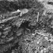
The evaluation trench also revealed that the main rampart consisted of a 6.5m wide wall with interior and exterior built faces supporting loose wall core with evidence for structured layering. Radiocarbon dates from alder and birch charcoal samples taken from within the primary collapsed wall core against both outer and inner faces produced radiocarbon dates of 409–235 cal BC and 461–176 cal BC, respectively (95.4% probability, SUERC-63281 and SUERC-63285), providing the likely time period of the burning and abandonment of the primary structure.
Only a very small amount of environmental material and a small assemblage of animal bone were recovered, indicating the presence of pig and sheep and/or goat on the site. While there had been four samples of animal bone fragments selected for radiocarbon dating, all of them failed due to insufficient carbon.
The results have provided evidence that the inner rampart at Craig Phadrig was re-fortified after the primary burning event. At the same time, it also appears that the inner rampart was re-occupied, probably re-fortified for a third time during the 11-12th centuries.
Archive: National Record of the Historic Environment (NRHE) intended
Funder: Forestry Commission Scotland
Mary Peteranna – AOC Archaeology Group and West Coast Archaeological Services
(Source: DES, Volume 16)
Note (12 March 2015 - 26 October 2016)
Craig Phadrig, the steep and wooded hill that rises abruptly on the western outskirts of inverness is crowned by a spectacular fort. Its defences comprise two walls, the inner of which is a massive vitrified structure reduced to a bank about 12m thick and 1.4m high internally taking in a subrectangular area on the elongated summit of the hill measuring some 72m from NE to SW by 22m transversely (0.18ha). The outer wall appears to be of slighter proportions around most of the circuit and appears to be accompanied by an internal quarry in some sectors, following a roughly concentric line around the NE, NW and SW, only to diverge along the SE flank to an angle on the E; an external ditch and an outer rampart on the NE follow this same course, the rampart terminating at its S end above what is almost certainly the site of an entrance, though the inner end of the passage is blocked by the collapsed outer wall. In common with other subrectangular forts with heavily vitrified walls, there is no evidence of an entrance into the inner enclosure on the summit; a feature variously described as an entrance (Headland 2011) and a barrow-run (RCAHMS 2014, 8) almost certainly overlies the defences and probably facilitated later access into the interior. Traces of the excavation trenches dug in 1971 can be seen within the interior, where Alan Small identified two main phases of occupation, apparently separated by a long period of abandonment; the later occupation was evidently early medieval, finds from a floor including sherds of E Ware and a fragment of a mould for a hanging bowl escutcheon (Small and Cottam 1972). There are seven radiocarbon dates from various samples of timber from beneath and within the walls, and the interior, but the brackets of their probabilities are so wide as to be of little use in dating the defences.
Following the second season of excavation in 1972, Alan Small claimed that the inner wall had been reconstructed following its catastrophic destruction and vitrification (1972), though whether this refortification related to the early medieval occupation is unclear. He also cryptically describes on the NE 'a double rampart, the impression of a third being created by the ditch from which the material for the outer rampart had been upcast' (1972). Apparently he dismissed the outermost rampart that the most recent surveys by Headland Archaeology and RCAHMS have identified in this sector, but there must be some doubt in the light of these surveys and the identification of a blocked entrance on the E whether the ditch was an external accompaniment to the outer of the walls here, which had also been burnt, or was an internal quarry for a robbed rampart on its outer lip. Given the traces of internal quarrying elsewhere around the outer circuit, the latter is perhaps the more likely, in its turn indicating that the outer vitrified wall on this side is a secondary construction that not only blocks the entrance on the E but crosses the internal quarry at this point. As the RCAHMS investigators suggest (RCAHMS 2014), the outer circuit is perhaps the remains of the earliest fortification here, forming a polygonal enclosure measuring about 120m from NE to SW by a maximum of 60m transversely (0.6ha) within a rampart with an internal quarry and an entrance on the E. This rampart was robbed in antiquity to build the rectangular enclosure on the summit, explaining why Small failed to find any trace of it on the NW (1972). The inner enclosure was subsequently burnt and later reconstructed, though the chronology of these events is unknown. The outer vitrified wall on the NE, now appearing as the middle line of defence, appears to be an outwork to the inner enclosure, and given that it does not follow the line of the earlier rampart, we can guess that it was not conceived in the initial construction of the inner enclosure but is a later addition long after the rampart of the earlier fort had been robbed.
In 2015, remedial work following the removal of a wind-blown tree, revealed a phase of refurbishment in the medieval period, with a substantial timber palisade set along the crest of the inner ruined wall, which at this point proved to be 6.5m thick (Peteranna and Birch 2015); radiocarbon dates from this work have yet to be published.
Information from An Atlas of Hillforts of Great Britain and Ireland – 26 October 2016. Atlas of Hillforts SC2896

