
Pricing Change
New pricing for orders of material from this site will come into place shortly. Charges for supply of digital images, digitisation on demand, prints and licensing will be altered.
Ground Survey


Date 27 September 2010 - 22 February 2011
Event ID 933760
Category Recording
Type Ground Survey
Permalink http://canmore.org.uk/event/933760
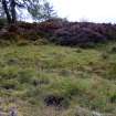
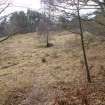
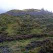
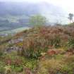
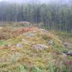
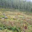
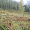
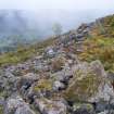
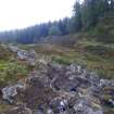
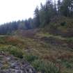
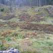
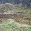
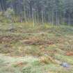
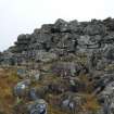
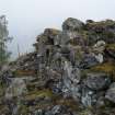
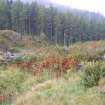
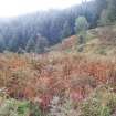
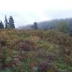
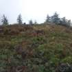
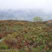
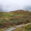
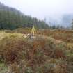
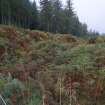
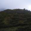
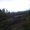
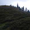
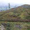
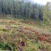
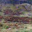
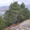
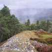
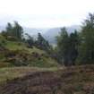
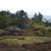
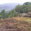
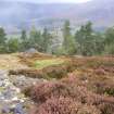
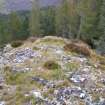
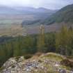
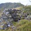
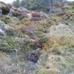
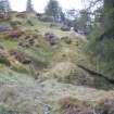
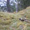
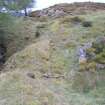
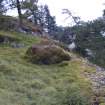
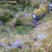
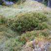
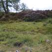
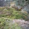
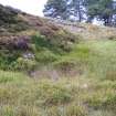
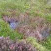
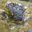
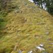
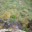
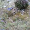
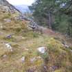
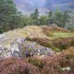
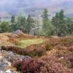
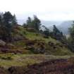
A topographic survey of five hillforts on Forestry Commission land was undertaken in September 2010, and completed in February 2011. The forts surveyed were: Caisteal Mac Tuathal, Kenmore (NN 7790 4765); Dun da Lamh, Laggan (NN 5823 9295); Dun Deardail, Fort William (NN 1270 7013); Tor Dhuin, Fort Augustus (NH 3485 0693) and Craig Phadrig, Inverness (NH 6400 4528). The survey aimed to produce plans at a scale of at least 1:1000. Two of the forts, Caisteal Mac Tuathal and Tor Dhuin are covered by dense bracken and its removal would significantly improve the appearance of these forts.
Archive: RCAHMS
Funder: Forestry Commission Scotland
Headland Archaeology Ltd, 2011
Information also reported in Oasis (headland1-95129) 4 August 2011
Ordnance Survey licence number AC0000807262. All rights reserved.
Canmore Disclaimer.
© Bluesky International Limited 2024.
|
Torr Dhuin
Dun (Period Unassigned), Fort (Period Unassigned), Vitrified Stone (Period Unknown)
Canmore ID 12212 |
|
|
Dun Deardail
Fort (Period Unassigned), Vitrified Stone (Period Unassigned)
Canmore ID 23727 |
|
|
Craig Phadrig
Fort (Prehistoric) - (Early Medieval), Vitrified Stone (Prehistoric)
Canmore ID 13486 |
|

DP 230712
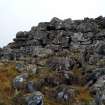
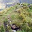
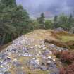
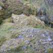
Caisteal Mac Tuathal, external rampart face at south-west corner, photo taken September 2010, illustration 2 from a report on a topographic archaeological survey at five Pictish Forts in the Highlands
Records from Headland Archaeology Ltd, archaeologists, Edinburgh, Scotland
9/2010
© Headland Archaeology Ltd. Courtesy of HES

DP 230713
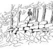
19th century sketch of Caisteal Mac Tuathal, illustration 2a from a report on a topographic archaeological survey at five Pictish Forts in the Highlands
Records from Headland Archaeology Ltd, archaeologists, Edinburgh, Scotland
9/2010
© Headland Archaeology Ltd. Courtesy of HES

DP 230714
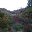
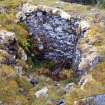
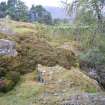
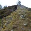
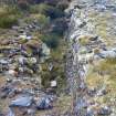
Caisteal Mac Tuathal, defensive ditch to the south of the fort, illustration 3 from a report on a topographic archaeological survey at five Pictish Forts in the Highlands
Records from Headland Archaeology Ltd, archaeologists, Edinburgh, Scotland
9/2010
© Headland Archaeology Ltd. Courtesy of HES

DP 230715
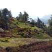
Dun da Lamh, east-facing view of interior, illustration 4 from a report on a topographic archaeological survey at five Pictish Forts in the Highlands
Records from Headland Archaeology Ltd, archaeologists, Edinburgh, Scotland
9/2010
© Headland Archaeology Ltd. Courtesy of HES

DP 230716
Dun da Lamh, inner rampart face exposed at north-west corner, illustration 5 from a report on a topographic archaeological survey at five Pictish Forts in the Highlands
Records from Headland Archaeology Ltd, archaeologists, Edinburgh, Scotland
9/2010
© Headland Archaeology Ltd. Courtesy of HES

DP 230717
Dun da Lamh, shelter possibly associated with World War II lookout, illustration 6 from a report on a topographic archaeological survey at five Pictish Forts in the Highlands
Records from Headland Archaeology Ltd, archaeologists, Edinburgh, Scotland
9/2010
© Headland Archaeology Ltd. Courtesy of HES

DP 230718
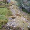
Dun da Lamh, possible hut-platform inside the north rampart, illustration 7 from a report on a topographic archaeological survey at five Pictish Forts in the Highlands
Records from Headland Archaeology Ltd, archaeologists, Edinburgh, Scotland
9/2010
© Headland Archaeology Ltd. Courtesy of HES

DP 230719
Dun Deadrail, west-facing view of interior, illustration 8 from a report on a topographic archaeological survey at five Pictish Forts in the Highlands
Records from Headland Archaeology Ltd, archaeologists, Edinburgh, Scotland
9/2010
© Headland Archaeology Ltd. Courtesy of HES

DP 230720
Dun Deadrail, slight erosion on top of north rampart, illustration 9 from a report on a topographic archaeological survey at five Pictish Forts in the Highlands
Records from Headland Archaeology Ltd, archaeologists, Edinburgh, Scotland
9/2010
© Headland Archaeology Ltd. Courtesy of HES

DP 230722
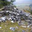
Craig Phadrig, south-west facing view of interior, illustration 11 from a report on a topographic archaeological survey at five Pictish Forts in the Highlands
Records from Headland Archaeology Ltd, archaeologists, Edinburgh, Scotland
9/2010
© Headland Archaeology Ltd. Courtesy of HES

DP 230723
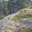
View of Caisteal Mac Tuathal from high ground to the south-west, illustration 12 from a report on a topographic archaeological survey at five Pictish Forts in the Highlands
Records from Headland Archaeology Ltd, archaeologists, Edinburgh, Scotland
9/2010
© Headland Archaeology Ltd. Courtesy of HES

DP 230726
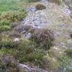
View towards annex to the north, photograph of Caisteal Mac Tuathal, from a topographic archaeological survey at five Pictish Forts in the Highlands
Records from Headland Archaeology Ltd, archaeologists, Edinburgh, Scotland
9/2010
© Headland Archaeology Ltd. Courtesy of HES

DP 230727
View towards north-east end of main rampart, photograph of Caisteal Mac Tuathal, from a topographic archaeological survey at five Pictish Forts in the Highlands
Records from Headland Archaeology Ltd, archaeologists, Edinburgh, Scotland
9/2010
© Headland Archaeology Ltd. Courtesy of HES

DP 230728
View towards the west corner of main rampart, photograph of Caisteal Mac Tuathal, from a topographic archaeological survey at five Pictish Forts in the Highlands
Records from Headland Archaeology Ltd, archaeologists, Edinburgh, Scotland
9/2010
© Headland Archaeology Ltd. Courtesy of HES

DP 230729
View towards outworks to the west, photograph of Caisteal Mac Tuathal, from a topographic archaeological survey at five Pictish Forts in the Highlands
Records from Headland Archaeology Ltd, archaeologists, Edinburgh, Scotland
9/2010
© Headland Archaeology Ltd. Courtesy of HES

DP 230730
View towards outworks to the west, photograph of Caisteal Mac Tuathal, from a topographic archaeological survey at five Pictish Forts in the Highlands
Records from Headland Archaeology Ltd, archaeologists, Edinburgh, Scotland
9/2010
© Headland Archaeology Ltd. Courtesy of HES

DP 230731
View north along main rampart from the west corner, photograph of Caisteal Mac Tuathal, from a topographic archaeological survey at five Pictish Forts in the Highlands
Records from Headland Archaeology Ltd, archaeologists, Edinburgh, Scotland
9/2010
© Headland Archaeology Ltd. Courtesy of HES

DP 230732
View south along main rampart from the west corner, photograph of Caisteal Mac Tuathal, from a topographic archaeological survey at five Pictish Forts in the Highlands
Records from Headland Archaeology Ltd, archaeologists, Edinburgh, Scotland
9/2010
© Headland Archaeology Ltd. Courtesy of HES

DP 230733
View towards east end of ditch, photograph of Caisteal Mac Tuathal, from a topographic archaeological survey at five Pictish Forts in the Highlands
Records from Headland Archaeology Ltd, archaeologists, Edinburgh, Scotland
9/2010
© Headland Archaeology Ltd. Courtesy of HES

DP 230735
View towards middle part of ditch, photograph of aisteal Mac Tuathal, from a topographic archaeological survey at five Pictish Forts in the Highlands
Records from Headland Archaeology Ltd, archaeologists, Edinburgh, Scotland
9/2010
© Headland Archaeology Ltd. Courtesy of HES

DP 230736
View towards west end of ditch, photograph of Caisteal Mac Tuathal, from a topographic archaeological survey at five Pictish Forts in the Highlands
Records from Headland Archaeology Ltd, archaeologists, Edinburgh, Scotland
9/2010
© Headland Archaeology Ltd. Courtesy of HES

DP 230737
Photograph of Caisteal Mac Tuathal, from a topographic archaeological survey at five Pictish Forts in the Highlands
Records from Headland Archaeology Ltd, archaeologists, Edinburgh, Scotland
9/2010
© Headland Archaeology Ltd. Courtesy of HES

DP 230738
Surviving outer rampart at the west corner, photograph of Caisteal Mac Tuathal, from a topographic archaeological survey at five Pictish Forts in the Highlands
Records from Headland Archaeology Ltd, archaeologists, Edinburgh, Scotland
9/2010
© Headland Archaeology Ltd. Courtesy of HES

DP 230739
Surviving outer rampart at the west corner, photograph of Caisteal Mac Tuathal, from a topographic archaeological survey at five Pictish Forts in the Highlands
Records from Headland Archaeology Ltd, archaeologists, Edinburgh, Scotland
9/2010
© Headland Archaeology Ltd. Courtesy of HES

DP 230740
View towards the south-west part of the fort interior, photograph of Caisteal Mac Tuathal, from a topographic archaeological survey at five Pictish Forts in the Highlands
Records from Headland Archaeology Ltd, archaeologists, Edinburgh, Scotland
9/2010
© Headland Archaeology Ltd. Courtesy of HES

DP 230741
View towards the south-west part of the fort interior, photograph of Caisteal Mac Tuathal, from a topographic archaeological survey at five Pictish Forts in the Highlands
Records from Headland Archaeology Ltd, archaeologists, Edinburgh, Scotland
9/2010
© Headland Archaeology Ltd. Courtesy of HES

DP 230742
View towards the east part of the fort interior, photograph of Caisteal Mac Tuathal, from a topographic archaeological survey at five Pictish Forts in the Highlands
Records from Headland Archaeology Ltd, archaeologists, Edinburgh, Scotland
9/2010
© Headland Archaeology Ltd. Courtesy of HES

DP 230743
View towards the north-east part of the fort interior, photograph of Caisteal Mac Tuathal, from a topographic archaeological survey at five Pictish Forts in the Highlands
Records from Headland Archaeology Ltd, archaeologists, Edinburgh, Scotland
9/2010
© Headland Archaeology Ltd. Courtesy of HES

DP 230744
View towards the north part of the fort interior, photograph of Caisteal Mac Tuathal, from a topographic archaeological survey at five Pictish Forts in the Highlands
Records from Headland Archaeology Ltd, archaeologists, Edinburgh, Scotland
9/2010
© Headland Archaeology Ltd. Courtesy of HES

DP 230745
View towards the north-west part of the fort interior, photograph of Caisteal Mac Tuathal, from a topographic archaeological survey at five Pictish Forts in the Highlands
Records from Headland Archaeology Ltd, archaeologists, Edinburgh, Scotland
9/2010
© Headland Archaeology Ltd. Courtesy of HES

DP 230746
View towards the west part of the fort interior, photograph of Caisteal Mac Tuathal, from a topographic archaeological survey at five Pictish Forts in the Highlands
Records from Headland Archaeology Ltd, archaeologists, Edinburgh, Scotland
9/2010
© Headland Archaeology Ltd. Courtesy of HES

DP 230747
View along the ditch towards the east, photograph of Caisteal Mac Tuathal, from a topographic archaeological survey at five Pictish Forts in the Highlands
Records from Headland Archaeology Ltd, archaeologists, Edinburgh, Scotland
9/2010
© Headland Archaeology Ltd. Courtesy of HES

DP 230748
View along the ditch towards the north-west, photograph of Caisteal Mac Tuathal, from a topographic archaeological survey at five Pictish Forts in the Highlands
Records from Headland Archaeology Ltd, archaeologists, Edinburgh, Scotland
9/2010
© Headland Archaeology Ltd. Courtesy of HES

DP 230749
Fort seen from high ground to the south of ditch, photograph of Caisteal Mac Tuathal, from a topographic archaeological survey at five Pictish Forts in the Highlands
Records from Headland Archaeology Ltd, archaeologists, Edinburgh, Scotland
9/2010
© Headland Archaeology Ltd. Courtesy of HES

DP 230750
View towards east end of ditch, photograph of Caisteal Mac Tuathal, from a topographic archaeological survey at five Pictish Forts in the Highlands
Records from Headland Archaeology Ltd, archaeologists, Edinburgh, Scotland
9/2010
© Headland Archaeology Ltd. Courtesy of HES

DP 230751
View towards east half of ditch, photograph of Caisteal Mac Tuathal, from a topographic archaeological survey at five Pictish Forts in the Highlands
Records from Headland Archaeology Ltd, archaeologists, Edinburgh, Scotland
9/2010
© Headland Archaeology Ltd. Courtesy of HES

DP 230752
View towards fort and middle part of ditch, photograph of Caisteal Mac Tuathal, from a topographic archaeological survey at five Pictish Forts in the Highlands
Records from Headland Archaeology Ltd, archaeologists, Edinburgh, Scotland
9/2010
© Headland Archaeology Ltd. Courtesy of HES

DP 230753
View towards west side of fort and west end of ditch, photograph of Caisteal Mac Tuathal, from a topographic archaeological survey at five Pictish Forts in the Highlands
Records from Headland Archaeology Ltd, archaeologists, Edinburgh, Scotland
9/2010
© Headland Archaeology Ltd. Courtesy of HES

DP 230754
View towards west end of ditch, photograph of Caisteal Mac Tuathal, from a topographic archaeological survey at five Pictish Forts in the Highlands
Records from Headland Archaeology Ltd, archaeologists, Edinburgh, Scotland
9/2010
© Headland Archaeology Ltd. Courtesy of HES

DP 230755
Photograph of Caisteal Mac Tuathal, from a topographic archaeological survey at five Pictish Forts in the Highlands
Records from Headland Archaeology Ltd, archaeologists, Edinburgh, Scotland
9/2010
© Headland Archaeology Ltd. Courtesy of HES

DP 230756
Panoramic view of Caisteal Mac Tuathal, from a topographic archaeological survey at five Pictish Forts in the Highlands
Records from Headland Archaeology Ltd, archaeologists, Edinburgh, Scotland
9/2010
© Headland Archaeology Ltd. Courtesy of HES

DP 230757
Panoramic view of Caisteal Mac Tuathal, from a topographic archaeological survey at five Pictish Forts in the Highlands
Records from Headland Archaeology Ltd, archaeologists, Edinburgh, Scotland
9/2010
© Headland Archaeology Ltd. Courtesy of HES

DP 230758
Panoramic view of Caisteal Mac Tuathal, from a topographic archaeological survey at five Pictish Forts in the Highlands
Records from Headland Archaeology Ltd, archaeologists, Edinburgh, Scotland
9/2010
© Headland Archaeology Ltd. Courtesy of HES

DP 230759
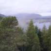
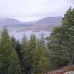
View towards the south-west from the fort, photograph of Dun da Lamh, from a topographic archaeological survey at five Pictish Forts in the Highlands
Records from Headland Archaeology Ltd, archaeologists, Edinburgh, Scotland
9/2010
© Headland Archaeology Ltd. Courtesy of HES

DP 230760
View towards the River Spey from the fort, photograph of Dun da Lamh, from a topographic archaeological survey at five Pictish Forts in the Highlands
Records from Headland Archaeology Ltd, archaeologists, Edinburgh, Scotland
9/2010
© Headland Archaeology Ltd. Courtesy of HES

DP 230761
View towards the River Spey from the fort, photograph of Dun da Lamh, from a topographic archaeological survey at five Pictish Forts in the Highlands
Records from Headland Archaeology Ltd, archaeologists, Edinburgh, Scotland
9/2010
© Headland Archaeology Ltd. Courtesy of HES

DP 230762
View towards path leading up to the fort from the south west, photograph of Dun da Lamh, from a topographic archaeological survey at five Pictish Forts in the Highlands
Records from Headland Archaeology Ltd, archaeologists, Edinburgh, Scotland
9/2010
© Headland Archaeology Ltd. Courtesy of HES

DP 230763
View towards north west corner of fort, photograph of Dun da Lamh, from a topographic archaeological survey at five Pictish Forts in the Highlands
Records from Headland Archaeology Ltd, archaeologists, Edinburgh, Scotland
9/2010
© Headland Archaeology Ltd. Courtesy of HES

DP 230764
View towards south east part of fort, photograph of Dun da Lamh, from a topographic archaeological survey at five Pictish Forts in the Highlands
Records from Headland Archaeology Ltd, archaeologists, Edinburgh, Scotland
9/2010
© Headland Archaeology Ltd. Courtesy of HES

DP 230765
View towards north east end of fort, photograph of Dun da Lamh, from a topographic archaeological survey at five Pictish Forts in the Highlands
Records from Headland Archaeology Ltd, archaeologists, Edinburgh, Scotland
9/2010
© Headland Archaeology Ltd. Courtesy of HES

DP 230766
View towards north side of fort, photograph of Dun da Lamh, from a topographic archaeological survey at five Pictish Forts in the Highlands
Records from Headland Archaeology Ltd, archaeologists, Edinburgh, Scotland
9/2010
© Headland Archaeology Ltd. Courtesy of HES

DP 230767
View towards north west corner of fort, photograph of Dun da Lamh, from a topographic archaeological survey at five Pictish Forts in the Highlands
Records from Headland Archaeology Ltd, archaeologists, Edinburgh, Scotland
9/2010
© Headland Archaeology Ltd. Courtesy of HES

DP 230768
View along west rampart, photograph of Dun da Lamh, from a topographic archaeological survey at five Pictish Forts in the Highlands
Records from Headland Archaeology Ltd, archaeologists, Edinburgh, Scotland
9/2010
© Headland Archaeology Ltd. Courtesy of HES

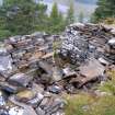
DP 230769
Modern structure built into the east rampart, photograph of Dun da Lamh, from a topographic archaeological survey at five Pictish Forts in the Highlands
Records from Headland Archaeology Ltd, archaeologists, Edinburgh, Scotland
9/2010
© Headland Archaeology Ltd. Courtesy of HES

DP 230770
Modern structure built into the east rampart, photograph of Dun da Lamh, from a topographic archaeological survey at five Pictish Forts in the Highlands
Records from Headland Archaeology Ltd, archaeologists, Edinburgh, Scotland
9/2010
© Headland Archaeology Ltd. Courtesy of HES

DP 230771
View towards south corner of fort, photograph of Dun da Lamh, from a topographic archaeological survey at five Pictish Forts in the Highlands
Records from Headland Archaeology Ltd, archaeologists, Edinburgh, Scotland
9/2010
© Headland Archaeology Ltd. Courtesy of HES

DP 230772
View towards natural spur at south corner of fort, photograph of Dun da Lamh, from a topographic archaeological survey at five Pictish Forts in the Highlands
Records from Headland Archaeology Ltd, archaeologists, Edinburgh, Scotland
9/2010
© Headland Archaeology Ltd. Courtesy of HES

DP 230773
View towards Strath Mashie from south corner of fort, photograph of Dun da Lamh, from a topographic archaeological survey at five Pictish Forts in the Highlands
Records from Headland Archaeology Ltd, archaeologists, Edinburgh, Scotland
9/2010
© Headland Archaeology Ltd. Courtesy of HES

DP 230774
Modern structure built into the rampart at south corner of fort, photograph of Dun da Lamh, from a topographic archaeological survey at five Pictish Forts in the Highlands
Records from Headland Archaeology Ltd, archaeologists, Edinburgh, Scotland
9/2010
© Headland Archaeology Ltd. Courtesy of HES

DP 230775
Line of inside face of rampart north east of south corner, photograph of Dun da Lamh, from a topographic archaeological survey at five Pictish Forts in the Highlands
Records from Headland Archaeology Ltd, archaeologists, Edinburgh, Scotland
9/2010
© Headland Archaeology Ltd. Courtesy of HES

DP 230776
View towards possible entrance in the south rampart, photograph of Dun da Lamh, from a topographic archaeological survey at five Pictish Forts in the Highlands
Records from Headland Archaeology Ltd, archaeologists, Edinburgh, Scotland
9/2010
© Headland Archaeology Ltd. Courtesy of HES

DP 230777
Dip in the rampart indicating a possible entrance, photograph of Dun da Lamh, from a topographic archaeological survey at five Pictish Forts in the Highlands
Records from Headland Archaeology Ltd, archaeologists, Edinburgh, Scotland
9/2010
© Headland Archaeology Ltd. Courtesy of HES

DP 230778
View along south rampart and possible entrance, photograph of Dun da Lamh, from a topographic archaeological survey at five Pictish Forts in the Highlands
Records from Headland Archaeology Ltd, archaeologists, Edinburgh, Scotland
9/2010
© Headland Archaeology Ltd. Courtesy of HES

DP 230779
View along middle part of south rampart, photograph of Dun da Lamh, from a topographic archaeological survey at five Pictish Forts in the Highlands
Records from Headland Archaeology Ltd, archaeologists, Edinburgh, Scotland
9/2010
© Headland Archaeology Ltd. Courtesy of HES

DP 230780
View along middle part of south rampart, photograph of Dun da Lamh, from a topographic archaeological survey at five Pictish Forts in the Highlands
Records from Headland Archaeology Ltd, archaeologists, Edinburgh, Scotland
9/2010
© Headland Archaeology Ltd. Courtesy of HES

DP 230781
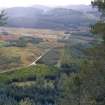
View across Strath Mashie from east end of fort, photograph of Dun da Lamh, from a topographic archaeological survey at five Pictish Forts in the Highlands
Records from Headland Archaeology Ltd, archaeologists, Edinburgh, Scotland
9/2010
© Headland Archaeology Ltd. Courtesy of HES

DP 230782
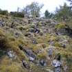
Collapsed rampart material below south east side of fort, photograph of Dun da Lamh, from a topographic archaeological survey at five Pictish Forts in the Highlands
Records from Headland Archaeology Ltd, archaeologists, Edinburgh, Scotland
9/2010
© Headland Archaeology Ltd. Courtesy of HES

DP 230783
Collapsed rampart material below east side of fort, photograph of Dun da Lamh, from a topographic archaeological survey at five Pictish Forts in the Highlands
Records from Headland Archaeology Ltd, archaeologists, Edinburgh, Scotland
9/2010
© Headland Archaeology Ltd. Courtesy of HES

DP 230784
View along north rampart from north east corner of fort, photograph of Dun da Lamh, from a topographic archaeological survey at five Pictish Forts in the Highlands
Records from Headland Archaeology Ltd, archaeologists, Edinburgh, Scotland
9/2010
© Headland Archaeology Ltd. Courtesy of HES

DP 230785
Hollow on inside north rampart near north east corner of fort, photograph of Dun da Lamh, from a topographic archaeological survey at five Pictish Forts in the Highlands
Records from Headland Archaeology Ltd, archaeologists, Edinburgh, Scotland
9/2010
© Headland Archaeology Ltd. Courtesy of HES

DP 230786
Platform just inside north rampart, photograph of Dun da Lamh, from a topographic archaeological survey at five Pictish Forts in the Highlands
Records from Headland Archaeology Ltd, archaeologists, Edinburgh, Scotland
9/2010
© Headland Archaeology Ltd. Courtesy of HES

DP 230787
Platform just inside north rampart, photograph of Dun da Lamh, from a topographic archaeological survey at five Pictish Forts in the Highlands
Records from Headland Archaeology Ltd, archaeologists, Edinburgh, Scotland
9/2010
© Headland Archaeology Ltd. Courtesy of HES

DP 230788
View along line of middle part of north rampart, photograph of Dun da Lamh, from a topographic archaeological survey at five Pictish Forts in the Highlands
Records from Headland Archaeology Ltd, archaeologists, Edinburgh, Scotland
9/2010
© Headland Archaeology Ltd. Courtesy of HES

DP 230789
View towards possible entrance in the north rampart, photograph of Dun da Lamh, from a topographic archaeological survey at five Pictish Forts in the Highlands
Records from Headland Archaeology Ltd, archaeologists, Edinburgh, Scotland
9/2010
© Headland Archaeology Ltd. Courtesy of HES

DP 230790
View towards possible entrance in the north rampart, photograph of Dun da Lamh, from a topographic archaeological survey at five Pictish Forts in the Highlands
Records from Headland Archaeology Ltd, archaeologists, Edinburgh, Scotland
9/2010
© Headland Archaeology Ltd. Courtesy of HES

DP 230791
Small circular hollow built into rampart at foot of north west-facing crag, photograph of Dun da Lamh, from a topographic archaeological survey at five Pictish Forts in the Highlands
Records from Headland Archaeology Ltd, archaeologists, Edinburgh, Scotland
9/2010
© Headland Archaeology Ltd. Courtesy of HES

DP 230792
View along north rampart towards north west corner of fort, photograph of Dun da Lamh, from a topographic archaeological survey at five Pictish Forts in the Highlands
Records from Headland Archaeology Ltd, archaeologists, Edinburgh, Scotland
9/2010
© Headland Archaeology Ltd. Courtesy of HES

DP 230793
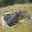
View towards well on north side of rocky knoll, photograph of Dun da Lamh, from a topographic archaeological survey at five Pictish Forts in the Highlands
Records from Headland Archaeology Ltd, archaeologists, Edinburgh, Scotland
9/2010
© Headland Archaeology Ltd. Courtesy of HES

DP 230794
Well seen from rocky knoll, photograph of Dun da Lamh, from a topographic archaeological survey at five Pictish Forts in the Highlands
Records from Headland Archaeology Ltd, archaeologists, Edinburgh, Scotland
9/2010
© Headland Archaeology Ltd. Courtesy of HES

DP 230795
Dug out hollow exposing inner rampart face at north west corner, photograph of Dun da Lamh, from a topographic archaeological survey at five Pictish Forts in the Highlands
Records from Headland Archaeology Ltd, archaeologists, Edinburgh, Scotland
9/2010
© Headland Archaeology Ltd. Courtesy of HES

DP 230796
View along west rampart seen from north west corner of fort, photograph of Dun da Lamh, from a topographic archaeological survey at five Pictish Forts in the Highlands
Records from Headland Archaeology Ltd, archaeologists, Edinburgh, Scotland
9/2010
© Headland Archaeology Ltd. Courtesy of HES

DP 230797
Photograph of Dun da Lamh, from a topographic archaeological survey at five Pictish Forts in the Highlands
Records from Headland Archaeology Ltd, archaeologists, Edinburgh, Scotland
9/2010
© Headland Archaeology Ltd. Courtesy of HES

DP 230798
Dug out hollow exposing inner rampart face at north west corner, photograph of Dun da Lamh, from a topographic archaeological survey at five Pictish Forts in the Highlands
Records from Headland Archaeology Ltd, archaeologists, Edinburgh, Scotland
9/2010
© Headland Archaeology Ltd. Courtesy of HES

DP 230799
Hollow dug into north half of west rampart, photograph of Dun da Lamh, from a topographic archaeological survey at five Pictish Forts in the Highlands
Records from Headland Archaeology Ltd, archaeologists, Edinburgh, Scotland
9/2010
© Headland Archaeology Ltd. Courtesy of HES

DP 230800
View along west rampart towards north west corner of fort, photograph of Dun da Lamh, from a topographic archaeological survey at five Pictish Forts in the Highlands
Records from Headland Archaeology Ltd, archaeologists, Edinburgh, Scotland
9/2010
© Headland Archaeology Ltd. Courtesy of HES

DP 230801
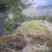
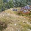
Modern path leading up to fort, photograph of Dun da Lamh, from a topographic archaeological survey at five Pictish Forts in the Highlands
Records from Headland Archaeology Ltd, archaeologists, Edinburgh, Scotland
9/2010
© Headland Archaeology Ltd. Courtesy of HES

DP 230802
Photograph of Dun da Lamh, from a topographic archaeological survey at five Pictish Forts in the Highlands
Records from Headland Archaeology Ltd, archaeologists, Edinburgh, Scotland
9/2010
© Headland Archaeology Ltd. Courtesy of HES

DP 230803
Slot exposing inner rampart face near middle of west rampart, photograph of Dun da Lamh, from a topographic archaeological survey at five Pictish Forts in the Highlands
Records from Headland Archaeology Ltd, archaeologists, Edinburgh, Scotland
9/2010
© Headland Archaeology Ltd. Courtesy of HES

DP 230804
View along west rampart towards north west corner of fort, photograph of Dun da Lamh, from a topographic archaeological survey at five Pictish Forts in the Highlands
Records from Headland Archaeology Ltd, archaeologists, Edinburgh, Scotland
9/2010
© Headland Archaeology Ltd. Courtesy of HES

DP 230805
Panoramic view towards the River Spey from the west rampart, photograph of Dun da Lamh, from a topographic archaeological survey at five Pictish Forts in the Highlands
Records from Headland Archaeology Ltd, archaeologists, Edinburgh, Scotland
9/2010
© Headland Archaeology Ltd. Courtesy of HES

DP 230806
Panoramic view towards north west corner of fort, photograph of Dun da Lamh, from a topographic archaeological survey at five Pictish Forts in the Highlands
Records from Headland Archaeology Ltd, archaeologists, Edinburgh, Scotland
9/2010
© Headland Archaeology Ltd. Courtesy of HES

DP 230807
Panoramic view of fort interior, photograph of Dun da Lamh, from a topographic archaeological survey at five Pictish Forts in the Highlands
Records from Headland Archaeology Ltd, archaeologists, Edinburgh, Scotland
9/2010
© Headland Archaeology Ltd. Courtesy of HES

DP 230808
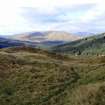
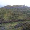
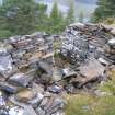
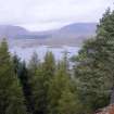
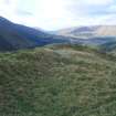
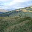
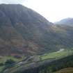
View towards Fort William from Dun Deardail, photograph from a topographic archaeological survey at five Pictish Forts in the Highlands
Records from Headland Archaeology Ltd, archaeologists, Edinburgh, Scotland
9/2010
© Headland Archaeology Ltd. Courtesy of HES

DP 230809
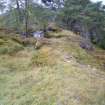
View along inside of south rampart, photograph of Dun Deardail, from a topographic archaeological survey at five Pictish Forts in the Highlands
Records from Headland Archaeology Ltd, archaeologists, Edinburgh, Scotland
9/2010
© Headland Archaeology Ltd. Courtesy of HES

DP 230810
View of fort interior from the east, photograph of Dun Deardail, from a topographic archaeological survey at five Pictish Forts in the Highlands
Records from Headland Archaeology Ltd, archaeologists, Edinburgh, Scotland
9/2010
© Headland Archaeology Ltd. Courtesy of HES

DP 230811
View along inside of north rampart, photograph of Dun Deardail, from a topographic archaeological survey at five Pictish Forts in the Highlands
Records from Headland Archaeology Ltd, archaeologists, Edinburgh, Scotland
9/2010
© Headland Archaeology Ltd. Courtesy of HES

DP 230812
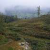
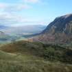
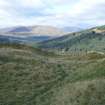
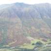
View towards Glen Nevis from Dun Deardail, from a topographic archaeological survey at five Pictish Forts in the Highlands
Records from Headland Archaeology Ltd, archaeologists, Edinburgh, Scotland
9/2010
© Headland Archaeology Ltd. Courtesy of HES

DP 230813
View towards Glen Nevis from Dun Deardail, from a topographic archaeological survey at five Pictish Forts in the Highlands
Records from Headland Archaeology Ltd, archaeologists, Edinburgh, Scotland
9/2010
© Headland Archaeology Ltd. Courtesy of HES

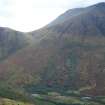
DP 230814
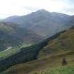
View towards Ben Nevis from Dun Deardail, from a topographic archaeological survey at five Pictish Forts in the Highlands
Records from Headland Archaeology Ltd, archaeologists, Edinburgh, Scotland
9/2010
© Headland Archaeology Ltd. Courtesy of HES

DP 230815
View towards north side of Ben Nevis from Dun Deardail, from a topographic archaeological survey at five Pictish Forts in the Highlands
Records from Headland Archaeology Ltd, archaeologists, Edinburgh, Scotland
9/2010
© Headland Archaeology Ltd. Courtesy of HES

First 100 images shown.

Archive from a topographic archaeological survey of Five Pictish Forts in the Highlands
Illustrations from a topographic archaeological survey of Five Pictish Forts in the Highlands
Photographs from a topographic archaeological survey of Five Pictish Forts in the Highlands
