
Pricing Change
New pricing for orders of material from this site will come into place shortly. Charges for supply of digital images, digitisation on demand, prints and licensing will be altered.
Torr Dhuin


Dun (Period Unassigned), Fort (Period Unassigned), Vitrified Stone (Period Unknown)
Site Name Torr Dhuin
Classification Dun (Period Unassigned), Fort (Period Unassigned), Vitrified Stone (Period Unknown)
Canmore ID 12212
Site Number NH30NW 1
NGR NH 3487 0695
Datum OSGB36 - NGR
Permalink http://canmore.org.uk/site/12212


- Council Highland
- Parish Boleskine And Abertarff
- Former Region Highland
- Former District Inverness
- Former County Inverness-shire
NH30NW 1 3487 0695.
(NH 3487 0695) Torr Dhuin (NAT) Vitrified Fort (NR) (Remains of)
OS 6"map, Inverness-shire, 2nd ed., (1904)
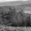
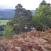
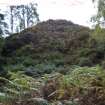
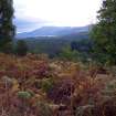
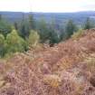
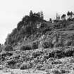
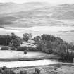
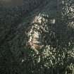
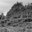
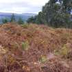
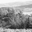
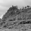
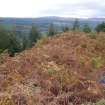
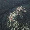
Surmounting Torr Dhuinn, or Torr Duin (R W Feachem 1963) , a rocky knoll whose E side is a 200' precipice, is a vitrified dun, with two possibly earlier outer unvitrified defences, protecting the N, W, and S arcs.
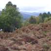
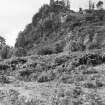
The dun is irregularly oval on plan, (T Wallace 1921) and measures c. 19.0m N-S by 10.0m within an overgrown vitrified wall c. 3.5m thick in the N where it is best preserved. No wall faces nor entrance are evident. A trench across the N half is probably an excavation trench. Outside the dun and enclosing the summit of the knoll are the poor remains of a wall which survives mainly as a terrace. A short stretch of wall core survives in the N and the discontinuous footings of the outer wall face can be traced in the N, W, and S arcs. Although there is some tumble below on the slope, the poor state of this wall suggests it has been robbed to build the dun. A gully leading up the slope in the SW is the entrance. It cuts through the line of the wall where its NW side is flanked by a line of earthfast stones, but its SE side is obscured and the width of the entrance is uncertain. Near the base of the knoll is a boulder-faced rubble wall with an entrance in the S. The inner face is visible for about 11.0m in the NW and one or two outer facing stones at this point give a wall thickness of 1.7m. A line of earthfast stones flanking the entrance suggests that here the wall increased to c. 3.0m. The other side of the entrance is mutilated and the width cannot be ascertained. Although Cotton (M A Cotton 1954) states that "traces of vitrification have been observed in this wall", only pieces that have fallen from the dun can be seen, and it is undoubtedly not vitrified. See 1:1250 enlargement. (OS [RD] 5 May 1964)
Visited by OS (A A) 21 October 1970; A Ross 1915
The outer face of the medial wall can also be traced in the E above the crags some 4.0m outside of and below the vitrified wall. Here are several large lumps of vitrifaction but these have probably dropped down from the dun wall. One stone on the W side of the entrance through the outer wall indicates an entrance width of 1.7m.
Visited by OS (JM) 6 September 1974
(NH 3485 0693) Torr Dhuin (NAT) Fort (NR)
OS 1/10000 map, (1970)
No change to previous field reports.
Revised at 1/10,000.
Visited by OS (J M) 19 February 1979
Field Visit (13 April 1957)
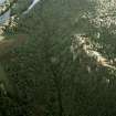
This fort is situated at a height of 250ft OD half a mile south of Auchteraw house on an isolated knoll the north-west, west and south-west flanks of which rise some 20 to 30 feet above the level of the adjacent land. In all other directions the ground falls steeply, in parts precipitously, from the summit for more than 200 ft to the floor of the valley of the River Oich. The fort conforms to the summit area of the knoll, measuring 50 ft in length from north-east to south-west by 25 ft transversely within the massive ruin of the stone wall among which large lumps of vitrifcation can be seen where the rank vegetation permits. The entrance is probably in the south-west. The base of the knoll is fortified, except along the brink of the precipitous south-east slope, by a wall now appearing as a mass of blocks and stones spread to as much as 15 ft in width. The entrance is in the SW.
Visited by RCAHMS 13 April 1957
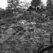
Ground Survey (27 September 2010 - 22 February 2011)
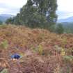
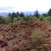
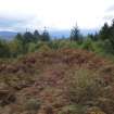
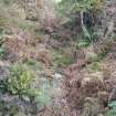
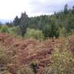
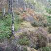
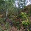
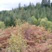
A topographic survey of five hillforts on Forestry Commission land was undertaken in September 2010, and completed in February 2011. The forts surveyed were: Caisteal Mac Tuathal, Kenmore (NN 7790 4765); Dun da Lamh, Laggan (NN 5823 9295); Dun Deardail, Fort William (NN 1270 7013); Tor Dhuin, Fort Augustus (NH 3485 0693) and Craig Phadrig, Inverness (NH 6400 4528). The survey aimed to produce plans at a scale of at least 1:1000. Two of the forts, Caisteal Mac Tuathal and Tor Dhuin are covered by dense bracken and its removal would significantly improve the appearance of these forts.
Archive: RCAHMS
Funder: Forestry Commission Scotland
Headland Archaeology Ltd, 2011
Information also reported in Oasis (headland1-95129) 4 August 2011
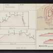
Digital Terrain Model (8 February 2014)
A topographical survey of the surviving vitrified stone walls enclosing the summit of a natural knoll at Torr Dhuin was undertaken by FRubicon Heritage Services Ltd. The site is located at NGR NH 3487 0695, to the southwest of Fort Augustus in the Parish of Bolekine and Abertarff, County of Inverness-shire. The site became a scheduled monument (SM794) in 1969. A detailed topographic survey was carried out by Rubicon Heritage Services in February 2014 on behalf of Forestry Commission Scotland. The site, situated in the forestry district of Inverness, Ross and Skye is managed by Forestry Commission Scotland. The purpose of the survey was to provide an enhanced baseline record of the upstanding remains at the site which will inform future conservation and management of the monument. Results from this survey recorded the nature and extent of surviving stonework within their immediate context as specified in the brief prepared by Forestry Commission Scotland.
Information from Louise Baker and Enda O'Flaherty (Rubicon Heritage Services Ltd) March 2014. OASIS ID: rubiconh1-189824
Note (2 March 2015 - 25 November 2016)
Occupying a rocky knoll above a precipitous crag that falls away abruptly into the valley of the River Oich on the E, this small fortification displays three roughly concentric lines of defence. The inner encloses the very summit of the knoll and measures 19m from NNE to SSW by about 10m transversely (0.02ha) within a heavily-vitrified wall reduced to a mound of rubble in excess of 3.5m in thickness where it is best preserved on the N and W flanks. The entrance is not visible, though probably on the SW and the only feature that can be seen within the heavily overgrown interior is an old excavation trench transecting the northern end. The second line of defence is a wall that extends around the shoulder of the summit area to enclose a larger area measuring about 38m along the same axis by a maximum of 18m transversely (0.06ha). Though reduced to a scarp everywhere except the N, in 1974 the OS surveyors were still able to trace the line of the outer face discontinuously round the whole circuit, but the only vitrified stones visible appeared to have tumbled from the innermost wall above. The entrance is on the SW, where a gully drops down the slope to the rear of the third line, yet another wall, extending around the foot of the knoll on the NW and S. Again, the OS observed a run of the inner face and a few outer facing-stones on the NW; here this third wall is about 1.7m in thickness, possibly increasing to about 3m adjacent to the entrance on the S. The sequence of construction is uncertain, though on the grounds that the middle wall seemed to be more heavily reduced than the inner, and that none of the pieces of vitrified stone they found on the lower walls appeared to be in situ, the OS were of the opinion that the inner enclosure on the summit had been inserted into an earlier fort.
Information from An Atlas of Hillforts of Great Britain and Ireland – 25 November 2016. Atlas of Hillforts SC2865

