Accessibility

Font Size

100% 150% 200%

Background Colour

Default Contrast
Close Reset

Inverness, Station Square, Inverness Station

Railway Station (19th Century) - (20th Century), War Memorial(S) (20th Century)

Site Name Inverness, Station Square, Inverness Station

Classification Railway Station (19th Century) - (20th Century), War Memorial(S) (20th Century)

Alternative Name(s) Station Yard; Academy Street; War Memorial Plaque

Canmore ID 13363

Site Number NH64NE 150

NGR NH 6678 4547

Datum OSGB36 - NGR

Permalink http://canmore.org.uk/site/13363

Ordnance Survey licence number AC0000807262. All rights reserved.
Canmore Disclaimer. © Bluesky International Limited 2025. Public Sector Viewing Terms

Toggle Aerial | View on large map

Digital Images

View of the covered section of the platform, Inverness Station.
View of the covered section of the platform, Inverness Station.Inverness, Station Square, Inverness Station
View of platform area with the Highland Railway centenary train leaving for ForresInterior
View showing ex-Highland Railway locomotive 103 in station during Highland Railway Centenary SpecialOblique aerial view of Inverness with the railway station to top right, taken from the E.Oblique aerial view.Oblique aerial view.General view from Academy StreetOblique aerial view centred on the railway station, taken from the NE.Aerial view of railway and Inverness Railway Station, looking W.Interior view from NInterior view from NInverness, Station Square, Inverness Station
View from E showing NE front of covered platformInverness, Station Square, Inverness Station; Interior
General view showing London sleeperOblique aerial view of the town centred on the railway station and garage with the churches adjacent, taken from the ENE.Oblique aerial view of the Citadel area of Inverness and the Longman Industrial Estate with Loch Ness beyond, taken from the NE.Interior view from NOblique aerial view.Oblique aerial view.Aerial view of the Eastgate Centre and Inverness Railway Station, looking NW.Inverness, Station Square, Inverness Station, interior
General view showing covered section of platformHighland Railway Centenary Special Train at Inverness Station, view from NE.Oblique aerial view of the town centred on the railway station and garage with the churches adjacent, taken from the NE.Oblique aerial view centred on Inverness Train Station, taken from the SW.Inverness, general view, showing Inverness Station and Academy Street.  Oblique aerial photograph taken facing west.  Oblique aerial view.Aerial view of Inverness and River Ness, looking SW.Detail of Highland Railway plaqueDetail of Highland Railway plaqueView from NNW showing N platforms with NNE and WNW fronts of terminal buildings in backgroundOblique aerial view.Oblique aerial view.Interior view from NEInverness, Station Square, Inverness Station, interior
General view showing covered section of platformView from NNE showing Highland Railway Centenary Special Train at Inverness StationOblique aerial view of the Citadel area of Inverness and the Longman Industrial Estate, taken from the NE.Oblique aerial view.Oblique aerial view.Oblique aerial view.Oblique aerial view.Detail of Director's plaqueInverness, Station Square, Inverness Station, interior
General view showing covered section of platformInverness, Station Square, Inverness Station; Interior
General view showing London sleeperView from N showing Highland Railway Centenary Special Train and another train at Inverness StationView of locomotive (?Highland Railway (H.R.) 460 103 ), Inverness railway stationLocation view from SWDetail of Highland Railway plaqueOblique aerial view.Oblique aerial view.Oblique aerial view.Aerial view of Longman Harbour and bridges over the River Ness, Inverness, looking SSE.Close aerial view of Eastgate Centre and Inverness Railway Station, looking W.Inverness, Station Square, Inverness Station, NH64NE 150, Ordnance Survey index card, RectoLocation view from SWView from NNE showing Highland Railway Centenary Special Train at Inverness StationOblique aerial view of the Citadel area of Inverness and the Longman Industrial Estate with Loch Ness beyond, taken from the NE.Oblique aerial view of the Citadel area of Inverness and the Longman Industrial Estate with Loch Ness beyond, taken from the NE.Oblique aerial view of  the Crown area of Inverness centred on the former Royal Academy with the Train Station adjacent, taken from the SW.Interior view from NEDetail of Director's plaqueOblique aerial view.Oblique aerial view.Oblique aerial view.Aerial view of east side of Inverness and part of Beauly Firth and Black Isle, looking NW.Interior view from NEDetail of Director's plaquePostcard of Inverness Railway Station inscribed 'Station Square, Inverness'.Oblique aerial view of the town centred on works with the railway station and garage adjacent, taken from the NNW.Oblique aerial view.Oblique aerial view.Oblique aerial view.Aerial view of Central Inverness, looking W.

Administrative Areas

  • Council Highland
  • Parish Inverness And Bona
  • Former Region Highland
  • Former District Inverness
  • Former County Inverness-shire

Archaeology Notes

NH64NE 150.00 6678 4547

NH64NE 150.01 NH 6684 4556 station frame (signal box)

NH64NE 150.02 NH 6725 4571 Welsh's Bridge Signal Box [NH64NE 394]

NH64NE 150.03 NH 6701 4566 Inverness Station, Signal Box

For lithic artifacts found during construction works, see NH64NE 31.

For (associated) Station Hotel (NH 66782 45430), see NH64NE 216.

See also:

NH64NE 139 NH 6710 4560 Millburn, Roundhouse

NH64NE 167.00 Centred NH 6693 4563 Lochgorm Railway Works and carriage sidings

NH64NE 394 NH 673 457 Welsh's Bridge, signal box and signal gantry

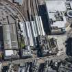
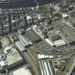
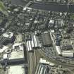
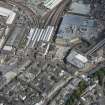
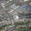
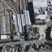
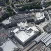
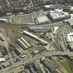
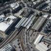
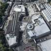
(Location cited as NH 667 455). Inverness Station, opened in 1855 by the Inverness and Nairn Rly, and since rebuilt and extended. The terminal buildings have recently been rebuilt but the iron overall roof over the inner ends of the platforms survives.

J R Hume 1977.

Railway station, Station Square.

J Gifford 1992.

This station was the major station of the former Highland Rly and remains in regular use by passenger traffic.

R V J Butt 1995.

Activities

Project (February 2014 - July 2014)

A data upgrade project to record war memorials.

References

MyCanmore Image Contributions


Contribute an Image

MyCanmore Text Contributions