
Pitlochry, Dam, Power Station And Fish Ladder


Dam (20th Century), Fish Ladder(S) (20th Century), Hydroelectric Power Station (20th Century)
Site Name Pitlochry, Dam, Power Station And Fish Ladder
Classification Dam (20th Century), Fish Ladder(S) (20th Century), Hydroelectric Power Station (20th Century)
Alternative Name(s) Pitlochry Salmon Ladder; Port-na-craig Dam; Loch Faskally; Tummel Garry Hydro-electric Scheme
Canmore ID 130503
Site Number NN95NW 62
NGR NN 93536 57750
Datum OSGB36 - NGR
Permalink http://canmore.org.uk/site/130503


- Council Perth And Kinross
- Parish Moulin
- Former Region Tayside
- Former District Perth And Kinross
- Former County Perthshire
NN95NW 62 93542 57719
See also NN95NW 104 and NN95NW 105.
Not to be confused with Clunie Dam, Pitlochry (NN 88432 60282), for which see NN86SE 66.
Port-na-Craig Dam [NAT] (at NN 9354 5780)
Power Station [NAT] (at NN 9353 5773)
Fish Ladder [NAT] (at NN 9355 5769)
OS 1:10,000 map, 1989.
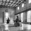
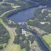
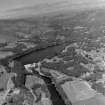
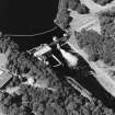
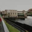
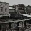
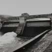
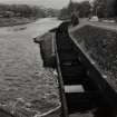
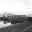
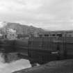
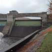
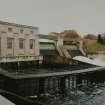
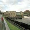
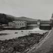
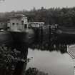
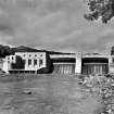
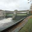
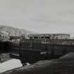
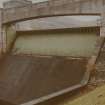
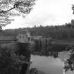
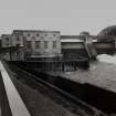
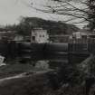
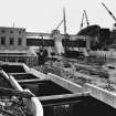
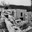
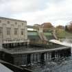
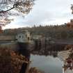
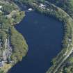
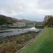
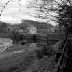
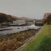
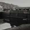
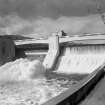
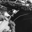
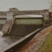
Pitlochry or Loch Faskally power station and dam, along with Clunie dam and power station (NN912 597) constitute the first stage of the Tummel-Garry hydro-electric scheme. Pitlochry has two 7,500kW sets which were both in operation by the end of December 1950. The power station and dam are considered to be, architecturally speaking, one of the most successful of the Hydro-Board's projects. There is no overhead 'clutter' of transformers or power lines as all power is transmitted underground to Clunie power station. The power station is faced in pre-cast concrete to fit in with the mass concrete dam.
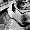
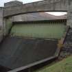
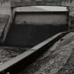
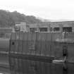
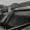
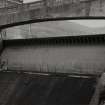
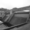
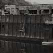
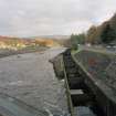
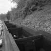
The two automatic drum gates were the first of their type and size used in Brtain (they were also installed at Clunie Dam) and were designed and built by Glenfield and Kennedy of Kilmarnock. These provide what Payne refers to as a 'sensitive spill', allowing for very little change in the reservoir levels. The hollow drum gates open automatically, rotating forward on a keel hinge at an angle of travel of 65 degrees into a flotation chamber, thus allowing the impounded water to spill over the crest.
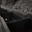
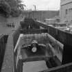
The fish ladder (along with the more extensive one at Clunie power station and dam) is of the 'pool and orifice' type.
P L Payne 1988.
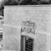
Pitlochry Power Station, Bridge, Dam and Fish Ladder, 1947-50. H O Tarbolton. Ingenious linear amalgamation of power station, bridge and dam across lower end of Loch Faskally, the man-made reservoir. Power station in monumental cubixc style, faced in granite forextra muscularity. Neart nan Gleann (Power of the Glens) reads the Hydro-Electric Board's motto on the N elevation, in case of doubt. Reservoir levels controlled by massive automatic drum gates, and fish ladder enables salmon to retirn to spawning grounds. Completed posthumously.
N Haynes 2000.
This group of structures forms a major element of the Tummel/Garry Hydro-electric Scheme.
Information from RCAHMS (RJCM), 20 February 2006.
Construction (1950)
Project (2007)
This project was undertaken to input site information listed in 'Civil engineering heritage: Scotland - Lowlands and Borders' by R Paxton and J Shipway, 2007.
Publication Account (2007)
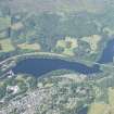
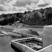
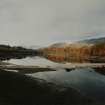
Within a few minutes walk from the centre of Pitlochry are the dam and integral generating station. The dam is 54 ft high and the station was designed principally to benefit the lower reaches of the Tummel by evening out the flow of water reaching Clunie power station (NN86SE ).
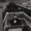
There are two automatic spillway drum gates at the dam each having a span of 90 ft. These and the fish ladder, 900 ft long with underwater observation chambers from which the fish can be viewed, have attracted much tourist interest. The generating machinery consists of two 7.5MW turbo alternators.
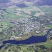
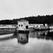
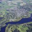
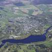
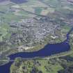
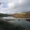
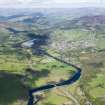
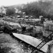
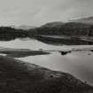
The construction of the Pitlochry dam, completed in 1950, led to the creation of Loch Faskally and the development of sailing, fishing and various forms of water sports making Pitlochry a major tourist centre attracting about 100 000 visitors each year. In the late 1940s and 1950s, when the works were being planned and constructed, Hydro Board staff and their consultant engineers were often ostracised and refused accommodation such was the fear that the works would blight the scenery and drive away visitors.
R Paxton and J Shipway
Reproduced from 'Civil Engineering heritage: Scotland - Lowlands and Borders' with kind permission of Thomas Telford Publishers.
Field Visit (2010)
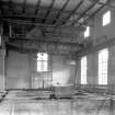
This is the bottom station on the Tummel scheme, and re-uses water that has been previously used to generate power up to 4 times. The station is integrated with the dam in a single structure behind which is created a man made reservoir in Loch Faskally. The dam section has a prominent walkway oversailing tow large drum gates which allow for flood management and control of the spill level. Minimum compensation is provided to the river, with a small compensation set. The turbine hall houses two large turbines. A fish pass is located to the south west end of the dam. The dam and station at Pitlochry are considered to be one of the most successful architectural designs by NoSHEB. The composition is confident in expressing the cutting edge nature of the industry with a muscular cubic design which is further re-enforced by the granite facing to the turbine hall and the large coat of arms with the legend ‘Power From The Glens’ emblazoned over the main entrance. The design for this building, set within a high profile scenic area and subject to powerful lobbying from influential Perthshire gentry was a test of the power and resolve of the board. The monumental nature of the final design is an expression of the confidence felt by the board at this time. PL Payne, 1988, 54; J Miller, 2002, 42: E Wood, 2002, 157-169; Scottish Hydro Electric, 2000, 18; J Gifford,2007, 671; C Liddell, 1993, 15, 110
Note (25 October 2023)
The Tummel-Garry hydroelectric power Scheme
The second of the Hydro Board's schemes was an extension of the Grampian Electricity Company's scheme. The Clunie Dam was constructed at the east end of Loch Tummel, increasing its size. A tunnel connects to Clunie power station below the Falls of Tummel. A dam was built at the east end of Loch Errochty whose water was fed by a tunnel and pipeline to a power station at the head of Loch Tummel. Finally, the River Tummel was impounded at Pitlochry forming Loch Faskally. The power station here is built into the dam and incorporates a fish ladder to allow salmon to pass. Loch Faskally forms a balancing reservoir for fluctuations in flow due to the Clunie power station's operations.
The scheme produces a total of 150,000 kW. Work started in 1946 and experienced similar problems to Loch Sloy due to shortages of labour and material, being completed in 1951.
This account relates to the Scottish Hydro collection of photographic images held at HES, Edinburgh. Compiled by a volunteer, Mr George Walker in 2005.
Information from HES (Miriam McDonald), 25 October 2023.

