
Pricing Change
New pricing for orders of material from this site will come into place shortly. Charges for supply of digital images, digitisation on demand, prints and licensing will be altered.
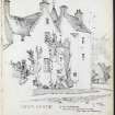
Drum Castle


Pottery Scatter (Post Medieval), Pottery Scatter (Medieval), Steps (17th Century), Tower House (Medieval), Wall (Period Unassigned), Water Channel (Period Unassigned)
Site Name Drum Castle
Classification Pottery Scatter (Post Medieval), Pottery Scatter (Medieval), Steps (17th Century), Tower House (Medieval), Wall (Period Unassigned), Water Channel (Period Unassigned)
Alternative Name(s) Drum Castle Estate; Drum Castle Policies
Canmore ID 18550
Site Number NJ70SE 4
NGR NJ 79620 00494
Datum OSGB36 - NGR
Permalink http://canmore.org.uk/site/18550


- Council Aberdeenshire
- Parish Drumoak
- Former Region Grampian
- Former District Kincardine And Deeside
- Former County Aberdeenshire
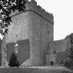
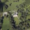
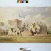
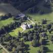
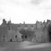
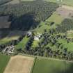
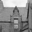
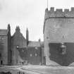
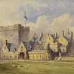
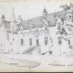
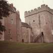
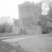
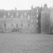
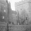
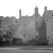
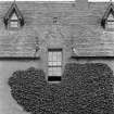
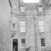
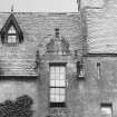
Built on lands granted to the Irvine family in the early 13th century, Drum Castle consists of a number of distinct structural elements. These include a thick-walled tower-house dating from the 13th century, a three-storey mansion house built in 1619, and Victorian additions from 1875, when the architect David Bryce was commissioned to design a hall, new front door and first floor corridor. It is now in the care of the National Trust for Scotland and is open to the public.
Information from RCAHMS (SC) 6 August 2007
Graham, C and Learmont, D 1977
NJ70SE 4.00 79620 00494
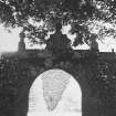
NJ70SE 4.01 79573 00465 Chapel
NJ70SE 4.02 79873 00644 Walled Garden
NJ70SE 4.03 7948 0031 Home Farm
NJ70SE 4.04 7945 0073 Kennels
NJ80SW 28 81446 00891 East Lodge
NO89NW 55 80376 99755 Mains of Drum
(NJ 7962 0050) Drum Castle (NR) Tower (NR)
OS 6" map, (1959)
The tower of Drum Castle is believed to have existed before 1324, when the Forest of Drum was made a free Barony for William de Irvin. Simpson (1949) suggests that it was probably built by Richard Cementarius (King's Master-mason), who was an alderman of Aberdeen in 1272. A Jacobean mansion was added to the tower in 1619.
W D Simpson 1943.
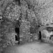
The tower is of simple rectangular form with slightly rounded corners, the walls measuring up to 12' in thickness. The only original entrance doorway is at first floor level, leading to the lord's hall and, by means of a mural stair, communicating with the basement where there is a well.
J G Dunbar 1966.
Excavation in the Upper Hall of the tower of Drum Castle revealed at least five phases of use. These included:
(1) a primary construction layer with wood chips and carpentry debris lying on top of the lower vault infill, which consisted of earth with an occasional turf and patches of moss or peat. On top of this infill were found an iron arrowhead, a piece of fabric and a short length of thin rope made from vegetable fibre.
(2) The floor debris from a first occupation phase from which the remains of a leather shoe were recovered. Enough survived to reveal the technique of manufacture as being of possible early 14th century date.
(3) A second occupation layer with two post holes but no datable artefacts.
(4) Remains of a screen and passageway along the east end of the hall, with associated occupation debris and sparse remains of the collapsed screen. Two post holes and two possible stone post-plinths lay in the north-east corner along with a small patch of cobbles, in the vicinity of where the stairs to the upper floor had stood.
(5) A post-screen occupation.
A number of small bronze or copper pins and a few small sherds of pottery were recovered from the passageway area.
Over 50 masons marks were observed while checking stonework of the hall and newall stair.
Two small trial trenches were cut in the cellar to establish the depth of deposit; it proved to be only c5cm deep. Bones, nutshells and grain were recovered. A small pit of 18th to 19th cenntury date was found to cut an earlier post hole which in turn cut a rat barrow. Down this rat hole, a small, hollow wooden artefact was found. It is 9cm long, tapers slightly from 1.7cm diameter to 0.7cm diameter and has been produced on a lathe. Two holes, slightly bevelled, are bored through one side c1cm apart and a single hole slightly further round towards the other side. It is uncertain what this object is although the possibility of it being some type of musical instrument is still being investigated. Sponsor: National Trust for Scotland.
M Greig 1991.
A trench was excavated by Kirkdale Archaeology against the W end of the S facade of the castle, in advance of new drainage work. Evidence for the clearance and levelling of the bedrock prior to 18th-century construction work was noted, alongside masons' waste and the drain associated with the new 18th-century structure.
Sponsor:National Trust for Scotland
G Ewart and P Sharman 1996
NJ 796 004 A watching brief was carried out on two small excavations: one for a dehumidifier soakaway for the chapel, the other a drain sump by the western front of the castle. Neither trench located any finds or features.
Sponsor: National Trust for Scotland
D Hind 1998
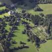
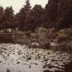
NJ 7963 0050 A desk-based assessment and walkover survey of the estate at Drum Castle took place in spring 1999. A total of 126 sites and monuments of archaeological or historic interest were identified, including those of an agricultural, industrial and ornamental nature. These range from rig and furrow cultivation remains, to mill and quarry features, to ornamental ponds. The sites vary in their respective ages (the cropmark sites could represent prehistoric activity dating from about 2000 BC to AD 1000), but also include modern activity.
Sponsor: National Trust for Scotland.
D Rankin and T Rees 2001
NJ 796 005 The installation of a new lightning protection system at Drum Castle involved the hand excavation of nine trenches 70cm square by 70cm deep in April 2002. The trenches were located on the N, E and S of the 13th-century Tower of Drum and to the E, S and the W of the 1619 mansion. In Trench 4, located E of the SE corner of the E projecting tower of the 1619 mansion, the battered foundations of the tower were revealed. They extended to a depth of c 75cm from where the batter begins and c 60cm below ground level, and are c 90cm out from the wall face of the tower. Trench 7, located N of the N wall of the SW projecting tower of the 1619 mansion, uncovered a stone wall running N-S. Its function is uncertain but it could represent an enclosing barmkin wall associated with the tower.
Archive to be deposited in the NMRS.
Sponsor: NTS.
J C Murray 2002
NJ 796 005 A rapid recording exercise was undertaken in August 2003 on capstones being lifted from the roof of the tower at Drum Castle. The constructional sequence was recorded, showing that the flagstones were laid onto a bed of gravel, around 5mm thick, overlapping with the adjacent step. There was no evidence of any damp-proofing.
Archive to be deposited in the NMRS.
Sponsor: NTS.
D Hind 2003
NJ70SE 4.00 79620 00494
NMRS REFERENCE:
Drum Castle:
Owner: H.Q.Forbe's Irvine.
Ancient keep with mansion of 1619.
Architect: David Bryce. Additions and alterations by John Bryce (possibly).
NMRS Plans:
Plan, elevation and section. - 1 sheet
Photostat sheets of elevations and plans (Originals held at Drum Castle). - 9 sheets
See also: D. Bryce folio in plan drawer.
NMRS PLANS:
Drawings from Schomberg-Scott.
48 drawings lent by Mrs. Irvine to SS and then presented by him to NMRS, August 1979. Comprising:
1) An early design for a walled garden, c. 1800.
48) An antiquarian survey of the old tower, c. 1876.
2-4) A survey of the Castle as existing in the early 1870's (or before).
5-7) A proposal to build a baronial screen to the entrance court and rebuild the entrance front to provide a new principal stair and entrance hall and corridors than 5-7 (David Bryce) 14.3.1876.
43)A single survivor of the working drawings for building the screen wall suggested in 5-7 (David Bryce) 14.3.1876.
8) A more ambitious scheme for a new principal stair and entrance hall and corridors than 5-7 which suggests that the screen No.43 was built in 1876 (John Bryce) February 1877.
9-35) Remains of working drawings (fragmentary) for new entrance front and stair as built 26th November 1878 - late 1880 (John Bryce). A compromise between David Bryce's and John Bryce, Feb 1877 proposal which preserved the old stair tower.
38-42) Designs for fitting up after alterations.
44, 46, 47) Drawing room chimneypiece November 1880.
45) A later plan for creating a bathroom. January 1893 (John Bryce).
EXTERNAL REFERENCE:
Drawings stored at 15 Pitstruan Place, Aberdeen. - Plans, elevations and details.
Measured and drawn by Frances J.H. Mercer, 1932.
See A.G.R. McK file.
Scottish National Portrait Gallery.
SMT Magazine, September 1950 - article and phototgraphs.
Modification (26 November 1878 - 31 August 1880)
Additions and alterations (possible) by John Bryce.
Photographic Record (1 July 1901 - 31 July 1901)
Photographic Record (16 June 1942)
Photographed by Angus Graham, Secretary to RCAHMS, as part of the Emergency Survey of buildings threatened with destruction. The photographs taken are listed in Graham's notebook MS 124/2, and all of the negatives survive.
Photographic Survey (1954)
Photographic survey by the Scottish National Buildings Record in 1954.
Photographic Survey (April 1955)
Photographic survey by the Scottish National Buildings Record in 1954.
Photographic Survey (12 July 1959)
Three photographs of Drum Castle, Aberdeenshire, taken in 1959.
Field Visit (1983)
Photographic Survey (1985)
Photographic Record (1985)
Photographic Record (1986)
Publication Account (1986)
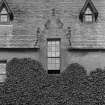
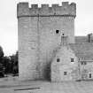
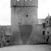
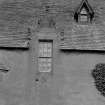
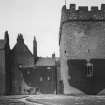
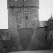
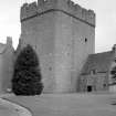
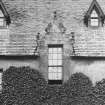
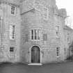
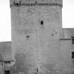
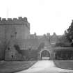
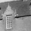
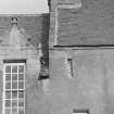
Of the many baronial residences of various dates that are to be seen in Grampian, the progenitor may be said to be the mighty Tower of Drum. Seven centuries old, with red granite walls 3.7m thick, it rises 21.5m to its corbelled wall-walk and deep crenellations. In plan it is a simple rectangle, 16.2m by 11.9m, with rounded corners.
It may have been built initially as a royal fortress, commanding the old road running north into the province of Mar from the Clyne Corse Mounth and the ford of Dee at the Mills of Drum. In 1323 king Robert gave the Forest of Drum to his armour-bearer William de Irwin; from then until 1976 the castle was in Irvine hands.
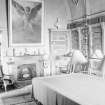
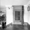
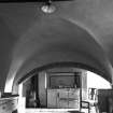
The original, first-floor entrance to the Tower survives, but not the protective barmkin that must have surrounded it. The Laigh Hall on the first floor was converted to a library in the 19th century and is now entered from the 17th century house. (It is still possible to appreciate the soaring medieval proportions of this room despite the distractions of the heraldic decoration of the vault and the bizarre Angel Gabriel self-portrait by Hugh Irvine.)
For a truly medieval experience, however, the visitor should climb the worn turnpike stair from the original Tower entrance to the vast pointed barrel-vaulted cavity above the Laigh Hall Here, with the timber floor of the third storey now gone (but its strong corbels still evident) the traveller can sit on a seven hundred yearold seat by a square open window within the bare, massive walls. In this dim light he can explore the garderobe in the north-west corner, whose channel falls 7.6m down through the wall.
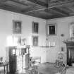
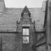
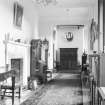
The parapet walk and high merlons at the top of the Tower are uniquely well preserved, although the original tall caphouse has gone. From here one can see the later additions to Drum, principally the mansion house of c 1619. Apart from its notable formal rooms, the lesser quarters are particularly fine, consisting principally the basement kitchen and dairy, which are ranged off a striking stone-flagged corridor that runs the full length of the building. Above stairs, the Green Closet, overlooking the front door, with its 18th century panelling and furniture of a practical elegance preserves much of the feel of life in the times of improvement.
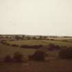
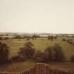
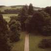
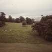
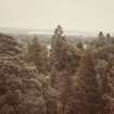
An important additional feature of Drum, one that links back beyond even the days of the Tower, is the fragment of the Old Wood that survives on the property. The enormous oaks and pines that stand at random and the gnarled geans (wild cherry trees) mingling with them are a remnant of the native Caledonian Forest that once cloaked most of the northeast. Something of the primeval atmosphere of that great forest can be gained from a walk in the Old Wood of Drum.
Information from ‘Exploring Scotland’s Heritage: Grampian’, (1986).
Photographic Survey (1986)
Excavation (1991)
Excavation in the Upper Hall of the tower of Drum Castle revealed at least five phases of use. These included:
(1) a primary construction layer with wood chips and carpentry debris lying on top of the lower vault infill, which consisted of earth with an occasional turf and patches of moss or peat. On top of this infill were found an iron arrowhead, a piece of fabric and a short length of thin rope made from vegetable fibre.
(2) The floor debris from a first occupation phase from which the remains of a leather shoe were recovered. Enough survived to reveal the technique of manufacture as being of possible early 14th century date.
(3) A second occupation layer with two post holes but no datable artefacts.
(4) Remains of a screen and passageway along the east end of the hall, with associated occupation debris and sparse remains of the collapsed screen. Two post holes and two possible stone post-plinths lay in the north-east corner along with a small patch of cobbles, in the vicinity of where the stairs to the upper floor had stood.
(5) A post-screen occupation.
A number of small bronze or copper pins and a few small sherds of pottery were recovered from the passageway area.
Over 50 masons marks were observed while checking stonework of the hall and newall stair.
Two small trial trenches were cut in the cellar to establish the depth of deposit; it proved to be only c5cm deep. Bones, nutshells and grain were recovered. A small pit of 18th to 19th cenntury date was found to cut an earlier post hole which in turn cut a rat barrow. Down this rat hole, a small, hollow wooden artefact was found. It is 9cm long, tapers slightly from 1.7cm diameter to 0.7cm diameter and has been produced on a lathe. Two holes, slightly bevelled, are bored through one side c1cm apart and a single hole slightly further round towards the other side. It is uncertain what this object is although the possibility of it being some type of musical instrument is still being investigated. Sponsor: National Trust for Scotland.
Publication Account (1996)
Of the many baronial residences of various dates that are to be seen in Grampian, the progenitor may be said to be the mighty Tower of Drum. Seven centuries old, with red granite walls 3.7m thick, it rises 21.5m to its corbelled wall-walk and deep crenellations. In plan it is a simple rectangle, 16.2m by 11.9m, with rounded corners.
It may have been built initially as a royal fortress, commanding the old road running north into the province of Mar from the Cryne Corse Mounth and the ford of Dee at the Mills of Drum. In 1323 king Robert gave the Forest of Drum to his armourbearer William de Irwin; from then until 1976 the castle was in Irvine hands.
The original, first-floor entrance to the Tower survives, but not the protective barmkin that must have surrounded it. The Laigh Hall on the first floor was converted to a library in the 19th century and is now entered from the 17th-century house. (It is still possible to appreciate the soaring medieval proportions of this room despite the distractions of the heraldic decoration of the vault and the bizarre Angel Gabriel self-portrait by Hugh Irvine.)
For a truly medieval experience, however, the visitor should climb the worn turnpike stair from the original Tower entrance to the vast pointed barrel-vaulted cavity above the Laigh Hall. Here, with the timber floor of the third storey now gone (but its strong corbels still evident) the traveller can sit on a seven hundred year-old seat by a square open window within the bare, massive walls. In this dim light can be explored the garderobe in the north-west corner, whose channel falls 7.6m down through the wall.
The parapet walk and high merlons at the top of the Tower are uniquely well preserved, although the original tall caphouse has gone. From here one can see the later additions to Drum, principally the mansion house of c 1619. Apart from its notable formal rooms, the lesser quarters are particularly fine, consisting principally the basement kitchen and dairy, which are ranged off a striking stoneflagged corridor that runs the full length of the building. Above stairs, the Green Closet, overlooking the front door, with its 18th-century panelling and furniture of a practical elegance preserves much of the feel of life in the times of improvement.
An important additional feature of Drum, one that links back beyond even the days of the Tower, is the fragment of the Old Wood that survives on the property. The enormous oaks and pines that stand at random and the gnarled geans (wild cherry trees) mingling with them are a remnant of the native Caledonian Forest that once cloaked most of the North-east. Something of the primeval atmosphere of that great forest can be gained from a walk in the Old Wood of Drum.
Information from ‘Exploring Scotland’s Heritage: Aberdeen and North-East Scotland’, (1996).
Excavation (1996)
A trench was excavated by Kirkdale Archaeology against the W end of the S facade of the castle, in advance of new drainage work. Evidence for the clearance and levelling of the bedrock prior to 18th-century construction work was noted, alongside masons' waste and the drain associated with the new 18th-century structure.
Sponsor:National Trust for Scotland
G Ewart and P Sharman 1996
Watching Brief (1998)
NJ 796 004 A watching brief was carried out on two small excavations: one for a dehumidifier soakaway for the chapel, the other a drain sump by the western front of the castle. Neither trench located any finds or features.
Field Visit (February 2000 - May 2000)
A1 The Tower, Drum Castle.
The buildings at Drum and their archaeology are largely outwith the scope of the present study, except insofar as some understanding of them is necessary to appreciate their inter-relationship with the development of the landscape and their functions and aesthetics as features within the landscape. Outline descriptions of all the principal buildings are given in Section 4.3, including the castle and tower. Here some archaeological findings of past investigations of the Tower and its environs are summarised.
Excavations were carried out by Moira Grieg for NTS in 1991 in the upper hall of the Tower and revealed at least five phases of use. These included:
1) A primary construction layer with wood chips and carpentry debris lying on top of the lower vault infill, which consisted of earth with an occasional turf and patches of moss or peat. On top of this infill were found an iron arrowhead, a piece of fabric and a short length of thin rope made from vegetable fibre.
2) The floor debris from a first occupation phase from which the remains of a leather shoe were recovered. Enough survived to reveal the technique of manufacture as being of possible early 14th century date.
3) A second occupation layer with two post-holes but no datable artefacts.
4) Remains of a screen and passageway along the east end of the hall, with associated occupation debris and sparse remains of the collapsed screen. Two post-holes and two possible stone post-plinths lay in the north-east corner along with a small patch of cobbles, in the vicinity of where the stairs to the upper floor had stood.
5) A post-screen occupation. A number of small bronze or copper pins and a few small sherds of pottery were recovered from the passageway area.
Over 50 masons’ marks were observed while checking stonework of the hall and newel stair.
Kirkdale Archaeology excavated a trench against the west end of the south façade of the castle in advance of new drainage work in 1996. Evidence for the clearance and levelling of the bedrock prior to 18th century construction work was noted, alongside possible masons’ waste and the drain associated with the new 18th century structure.
A watching brief was undertaken to observe the excavations for a dehumidifier soakaway for the chapel and a drain sump by the western front of the castle respectively. Neither trench contained any finds or features (Hind 1998, 8).
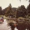
A resistivity survey of the south lawn area in 1988 by the University of Bradford’s Department of Archaeological Sciences, to investigate the gardens which are likely to have existed there prior to 1780s or 1790s.
(DRU00A1) Information from NTS (BNM) March 2014.
Project (2001)
NJ 7963 0050 A desk-based assessment and walkover survey of the estate at Drum Castle took place in spring 1999. A total of 126 sites and monuments of archaeological or historic interest were identified, including those of an agricultural, industrial and ornamental nature. These range from rig and furrow cultivation remains, to mill and quarry features, to ornamental ponds. The sites vary in their respective ages (the cropmark sites could represent prehistoric activity dating from about 2000 BC to AD 1000), but also include modern activity.
Excavation (2002)
NJ 796 005 The installation of a new lightning protection system at Drum Castle involved the hand excavation of nine trenches 70cm square by 70cm deep in April 2002. The trenches were located on the N, E and S of the 13th-century Tower of Drum and to the E, S and the W of the 1619 mansion. In Trench 4, located E of the SE corner of the E projecting tower of the 1619 mansion, the battered foundations of the tower were revealed. They extended to a depth of c 75cm from where the batter begins and c 60cm below ground level, and are c 90cm out from the wall face of the tower. Trench 7, located N of the N wall of the SW projecting tower of the 1619 mansion, uncovered a stone wall running N-S. Its function is uncertain but it could represent an enclosing barmkin wall associated with the tower.
Archive to be deposited in the NMRS.
Observation (1 August 2003 - 31 August 2003)
NJ 796 005 A rapid recording exercise was undertaken in August 2003 on capstones being lifted from the roof of the tower at Drum Castle. The constructional sequence was recorded, showing that the flagstones were laid onto a bed of gravel, around 5mm thick, overlapping with the adjacent step. There was no evidence of any damp-proofing.
Archive to be deposited in the NMRS.
Sponsor: NTS.
Excavation (25 February 2008 - 3 March 2008)
NJ 7962 0050 Work was undertaken, 25 February–3 March 2008, to establish the extent to which archaeological features survived in the S lawn of Drum Castle, which is used for public events. Documentary references suggest that a garden had existed here in the 17th–18th centuries and may have been created when the mansion-house was added to the castle in c1615–21. A geophysical survey in 1988 had indicated that
the garden plan survived.
The excavation revealed that the garden was in two parts; the part nearest the mansion was a fully walled garden with traces of possible geometric parterres. In the other part of the garden stone paths were excavated, alongside garden beds with revetting walls.
A small assemblage of medieval pottery and tile fragments was found in levelling material and probably derived from elsewhere on the castle site.
Archive and Report: NTS. Report: Aberdeenshire SMR and RCAHMS
Funder: The National Trust for Scotland
HK and JC Murray (Murray Archaeological Services Ltd), 2008
Standing Building Recording (November 2010 - January 2011)
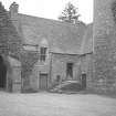
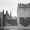
NJ 7963 0051 A historic building survey of the tower, brewhouse and cross chamber at Drum Castle was carried out in November 2010, with further research undertaken in January 2011. The study established that the buildings represent nine phases of development. The earliest was the construction of the Tower of Drum in a single phase, probably initiated shortly after 1323. The building works appear to have been spread over a minimum of four years, with a possible hiatus in the construction of the upper hall level and above. The hiatus marked a change in design, from only timber floors above the ground floor vault, to the provision of vaults above each of the entresol levels. The main access to the interior was via a door and stair in the N elevation. A timber stair recovered from the NE corner of the hall was dendrochronologically dated, by Anne Crone of AOC Archaeology, to the first half of the 15th century.
The subsequent phases of development included the addition of a one-storey hall range on the S side of the tower, dated to the mid-14th to 15th century. The site was developed further with the addition of an entrance building on the N side of the tower, dating to the late 15th or 16th century. The latter building was subsequently converted for service use, including a brewhouse, with the addition of the Jacobean S range in the early 17th century. This addition resulted in the demolition of the earlier hall range and the construction of the cross range to link the new range to the tower. Dendrochronological dating of the timbers by AOC indicated that the timbers of the cross range roof had been felled in 1603, 1607, 1608, and 1612. Comparison with previous analysis of timbers from the S range, which indicated felling in 1608 and 1609, confirms that the two were constructed contemporaneously.
From the 17th century, the tower appears to have been little used, but subsequent changes of use can be traced in the brewhouse and cross range from inventories and plans prepared in the 18th and 19th centuries.
Archive: RCAHMS (intended). Reports: Aberdeenshire Council SMR and NTS (intended)
Funder: The National Trust for Scotland
Jonathan Clark, FAS Heritage 2012
Earth Resistance Survey (22 July 2013 - 26 July 2013)
NJ 79620 00494 A geophysical survey that aimed to map potential structural remains and garden features associated with the castle was undertaken, 22–26 July 2013. A resistance survey at 0.5m by 0.5m intervals was undertaken on the lawns to the W, E and S of the castle, with GPR being conducted over gravel, tarmac and paved areas.
The resistance survey mapped many elements of the formal garden within the S lawn. Anomalies of possible interest were also noted within the W and E lawns, although, with the exception of two well defined responses from former paths, these are ephemeral. The GPR survey identified several anomalies of possible interest, including possible footings of a wall associated with the tower and potential structures in the NE of the courtyard. Numerous services were also detected.
Archive: Rose Geophysical Consultants
Funder: The National Trust for Scotland
Susan Ovenden, Rose Geophysical Consultants, 2013
(Source: DES)
Archaeological Evaluation (13 June 2013 - 18 July 2013)
NJ 7962 1893 A 7% evaluation was carried out, on 10 January 2013, on a low lying area adjacent to a site of prehistoric importance. No finds or features of archaeological significance were recorded.
Archive: RCAHMS (intended). Report: Aberdeenshire Council HER
Funder: International Paper (UK) Ltd
HK Murray and JC Murray, Murray Archaeological Services Ltd, 2013
(Source: DES)
Excavation (10 May 2014 - 6 June 2014)
As part of the Tower of Drum Major Repairs Project, excavations were undertaken in three areas around the base of the 14th-century tower at Drum Castle. In Area 1, within the courtyard, the cess pit relating to the garderobes in the tower was excavated. Sadly it had been cleaned out and backfilled with stony rubble. An earlier yard surface below the existing tarmac was considered to be of 19th-century date. In Area 2, between the brewhouse and the tower the foundations of a substantial stone building of probable 16th-century date were excavated. It had a stone paved floor with a slightly raised square setting at the centre of one wall possibly indicating a hearth. In Area 3 a path, drain and stone paved yard relating to the 17th-century Cross Range were excavated. The paving incorporated a number of re-used dressed stones, possibly from an earlier building on the S side of the tower. A small area of earlier paving may relate to the original steps to the tower.
Information from OASIS ID: mas1-207517 (J C Murray) 2014.
Watching Brief (30 October 2014 - 11 November 2014)
NJ 7962 0050 A watching brief was maintained, 30 October – 11 November 2014, in the courtyard at Drum Castle during the removal of existing tarmac and the levelling of underlying surfaces prior to resurfacing. A 19th-century yard surface, identified in excavations in the courtyard in May–June 2014, only survived in patches between trenches cut for services.
Details of the base of the wall of the 14th-century tower were recorded.
Archive: The National Trust for Scotland (intended). Report and
photographs: Aberdeenshire SMR and The National Trust for Scotland
Funder: The National Trust for Scotland
JC Murray and HK Murray – Murray Archaeological Services Ltd
(Source: DES)
Watching Brief (9 February 2015 - 19 May 2015)
NJ 79620 00500 A watching brief was carried out, 9 February – 19 May 2015, during earthworks associated with driveway repairs at Drum Castle. A drainage trench at the side of the drive cut across a substantial stone wall, 2.25m wide, and apparently running N/S, at NJ 79655 00546. It was sealed by a burnt layer. An abraded sherd of medieval or post-medieval pottery was found in the disturbed backfill of the later drain.
Archive: The National Trust for Scotland. Report: Aberdeenshire SMR and the National Trust for Scotland
Funder: The National Trust for Scotland
Hilary and Charlie Murray - Murray Archaeological Services Ltd
(Source: DES, Volume 16)
Watching Brief (7 March 2016)
NJ 79620 00500 A watching brief was maintained, 7 March 2016, on a drain for a pathway between the car park and the castle at Drum. Apart from a small area of cobbles, that may be a remnant of an earlier path, no archaeological features or finds were evident.
Archive: NTS. Report: Aberdeenshire SMR and NRHE
Funder: The National Trust for Scotland
Hilary and Charlie Murray – Murray Archaeological Services Ltd
(Source: DES)
Watching Brief (11 October 2016 - 10 November 2016)
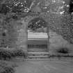
NJ 79620 00500 A watching brief was undertaken, 11 October – 10 November 2016, on a major new drain around the E, S, W and NW sides of the castle. While much of the ground had previously been disturbed by other service trenches, a set of stone steps of probable 17th-century date were excavated at the SW corner of the castle. They may relate to the formal 17th-century gardens which had lain in the area that is now the S lawn.
Archive: NTS. Report: Aberdeenshire SMR and NTS
Funder: National Trust for Scotland
Hilary and Charlie Murray – Murray Archaeological Services Ltd
(Source: DES, Volume 18)
Watching Brief (24 April 2017 - 25 April 2017)
NJ 79627 00411 (NJ70SE 4) A watching brief was undertaken, 24–25 April 2017, during the excavation of 63.5m of drainage ditches along the southern edge of the S lawn at Drum Castle. A fully functional hand-built stone culvert was uncovered, which was then utilised to assist with the drainage scheme.
Archive: NRHE
Funder: National Trust for Scotland
Robert Lenfert – Cameron Archaeology
(Source: DES, Volume 18)

