
Antonine Wall: Wilderness Plantation - Easter Cawder - Cadder


Frontier Defence (Roman)
Site Name Antonine Wall: Wilderness Plantation - Easter Cawder - Cadder
Classification Frontier Defence (Roman)
Alternative Name(s) Antonine Wall; Adamslee; Balmuildy Road; Cawder House Policies; Firhill Cottage; Torrance Roundabout
Canmore ID 45239
Site Number NS67SW 45
NGR NS 62500 72827
NGR Description NS 6000 7218 to NS 6500 7393
Datum OSGB36 - NGR
Permalink http://canmore.org.uk/site/45239


- Council East Dunbartonshire
- Parish Cadder (Strathkelvin-du)
- Former Region Strathclyde
- Former District Strathkelvin
- Former County Lanarkshire
NS67SW 45.00 6000 7218 to 6500 7393
NS67SW 45.01 NS 627 728 Glasgow Bridge; Trial Excavation
NS67SW 45.02 NS 6195 7276 Antonine Wall; Cadder; Trial Excavation [Cancelled]
NS67SW 45.03 NS 6000 7213 to NS c.6500 7393 Antonine Wall; Military Way
RRX505 600 721 to 609 725.
RRX505 642 735 to 635 730.
RRX505 620 727 to 632 729.
For fortlet at NS 6368 7310, see also NS67SW 21.
NS 603 723 The undercutting of a quarry face at the east end of the plantation (Robertson 1966) exposed sections of the rampart-base and of the upcast mound of the Wall. The rampart-base measured at least 4.6m across and had been laid in a construction-trench. The upcast mound was of orangey sand, covering the Roman turf-line, and measured c.18m wide.
L J F Keppie 1974; D R Wilson 1975.
NS 616 726 Observation of a pipe-line trench near the Forth and Clyde canal showed a deep build-up of earth. No trace of the stone base of the Antonine Wall was noted, but the S edge of the ditch was tentatively established.
S S Frere 1977; L J F Keppie 1976; A S Robertson 1966.
NS 6000 7218 to NS 6026 7228 The published course (OS 25 inch 1957) was resurveyed. No remains exist across the disused quarry. The new line is deduced from the 1st edition OS 2 and a half map, revised detail around Buchley Lodge (see NS57SE 42.00 : NS 5983 7214 to NS 6000 7218 for details) and RAF vertical aerial photograph (F21/ 58/ 1453, frame no 0422, 1954). The evidence at NS 6001 7217 is somewhat contradictory, the text stating excavations proved the OS published line (the newline coincides here) while the scale plan from the hedge-line of Balmuildy Road pushed the line at an unacceptable distance to the N. It is assumed that the plan scale is in error. (However, see also NS57SE 42.00 : NS 5996 7216 ).
NS 6000 7218 to NS 6001 7218 Four sections over a distance of 400ft. (continued from NS57SE 42.00 : NS 5996 7216 to NS 6000 7218) cut by the Ministry of Public Building Works prior to quarrying proved the Wall and Ditch are on the OS line in 1963 (Robertson 1966).
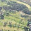
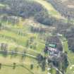
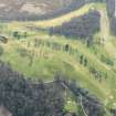
NS 6026 7228 to NS 6082 7250 Four sections cut by the Ministry of Public Building Works in 1963 over a distance of 600yds. On Cadder Golf Course confirmed the line of the Wall as shown by the OS (no locations given) (Robertson 1966).
The published course (OS 25 inch 1957) was resurveyed. Apart from one isolated well-defined length of the Ditch, at NS 6026 7228 to NS 6029 7230, which is up to 12m wide and about 2m deep, only a vague hollow of the Ditch line is visible bounding and crossing a golf course. Evidence at NS 6064 7245 and at the five sections located at NS 6027 7227, NS 6028 7228, NS 6037 7232, NS 6039 7232 and NS 6040 7233 confirms the extant 1st edition OS 2 and a half map survey of the Wall, Ditch and Outer Mound. The revised line with its definite alignment angles is deduced from ground indications and the 1st edition of the OS 2 and a half inch map (Lanark 1897, sheet 1/7 and 1/11). The five overgrown but open sections on the Wall line over a total distance of some 150m were verified. These are apparently unpublished, but were marked anonymously on a record OS 25 inch sheet in 1965. It must be assumed pending further inquiry that they form part of or are subsequent to the excavations on Cadder Golf Course (see Robertson 1966) although there are obvious discrepancies in account.
NS 6064 7245 The Wall base and turf superstructure were excavated at this point c. 1913 (Macdonald 1915).
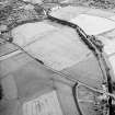
NS 6081 7245 The Military Way and the Ditch are well preserved in Cawder Wood (Horsley 1732).
NS 6082 7250 to NS 6100 7252 The published course (OS 25 inch 1957) was resurveyed. Macdonald's (1915) line is accepted; no surface trace is visible across the golf course. A soil mark consistent with the revised line is visible on RAF vertical aerial photographs (CPE/ SCOT/ 327, frame no 3037-8, 1948).
NS 6094 7251 The course of the Wall and alignment angle was determined by excavations on both sides of the road for a distance of over 100ft. about 1913. (Macdonald 1915).
NS 6100 7252 to NS 6200 7274 The published course (OS 25 inch 1958) was resurveyed. There are no surface remains; Macdonald's (1915) line has been generally accepted. Alignment angles have been sharpened and all are feasible on topographic and sighting grounds. The unlikely rounded curve at the Lodge has been straightened.
NS 6114 7259 The base of the Wall and the Military Way (at two points) were found by excavation about 1913 (Macdonald 1915).
NS 6122 7260 to NS 6156 7256 The course of the Wall and Ditch were found by repeated excavations between the Lodge and the canal, about 1913 (Macdonald 1915).
NS 6152 7254 The base of the Wall was stated to be visible in disused quarry immediately W of Cadder fort (NS67SW 16) (Price 1974).
NS 6155 7256 In 1976, excavations at a pipeline trench revealed no clear traces of the Wall or Ditch. This area was much disturbed (Keppie 1978).
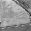
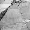
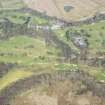
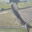
NS 6200 7274 to NS 6300 7287 The published course (OS 25 inch 1957) was resurveyed. No extant of the Wall remains across arable fields, although the line of the Ditch can often be traced as a crop or soil mark, or amorphous hollow. The revised line is based on ground indications and re-examination of the 1st edition of the OS 2 and a half inch map (Lanark 1897, sheet 1/8) which shows the extant line; CUCAP aerial photographs Q30 and U52 confirm parts of the line as do RAF vertical aerial photographs (F22/ 58/ 1453, frame no 0329-30, 1956).
NS 6217 7272 Slight remains of the Wall, much defaced in a strip of plantation. (Should read Military Way?) (ONB 1858).
NS 6300 7287 to NS 6356 7300 Remains of the Ditch are barely visible (Macdonald 1934).
The published survey (OS 25 inch 1958) was revised. No ground trace across smallholding on the E and then across arable field. Slight modifications on examination of extant line on the 1st edition of the OS 2 and a half inch map (Lanark 1897, sheet 1/8). OS Field Investigator noted no extant remains in 1957 (Information from OS 1957).
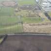
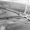
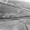
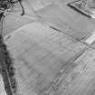
NS 6356 7300 to NS 6400 7334 The published course (OS 25 inch 1969) was resurveyed. The amorphous hollow of the Ditch line is still occasionally visible across arable fields. The 1st edition of the OS 2 and a half inch map (Lanark 1897, sheet 1/8). Shows the line as fairly extant with the Outer Mound and Rampart surveyed in short lengths. The new line, including the two sharpened alignment angles, is also deduced from ground indications where possible, RAF vertical aerial photographs (F21/ 82/ 1236, frame no 0170-1, 1955) and RCAHMS aerial photographs (LA 1416 (1976), LA 2226-8 (1977)). CUCAP aerial photograph AGH54 also shows the line approaching Glasgow Bridge.
NS 6400 7334 to NS 6419 7350 The published course (OS 25 inch 1969) was resurveyed. Only an amorphous hollow of the Ditch and the equally spread swelling of the Outer Mound survive in arable fields. There is no trace of the Rampart.
Resurvey based on surviving ground detail, the 2nd edition of the OS 2 and a half inch map (Stirlingshire 1898, sheet 33/5) which shows extant detail including the Rampart; and RCAHMS aerial photographs (LA 1431-15(1977) and LA 1486-87(1977)).
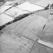
NS 6419 7350 to NS 6424 7366 The published course (OS 50 inch 1967) was resurveyed. From NS 6419 7350 an amorphous hollow of the Ditch and an equally spread swelling of the Outer Mound is discernible in an arable field until it crosses Park Burn in which no surface trace is visible across the developed area. The line is shown extant the 2nd edition of the OS 2 and a half inch map (Stirlingshire 1898, sheet 33/5) and the new line is based on the re-examination of this and of RCAHMS aerial photographs (LA 1413-5 (1977) and LA 1486-7 (1977) which clearly shows the Ditch line.
There is no known report of the Rampart being uncovered, but the 2nd edition of the OS 2 and a half inch map does show it as intermittently extant. In 1957, the OS Field Investigator noted large stones in the bed of the Park Burn where the line crosses and also noted with negative results a modern cutting across the accepted line in the area of NS 6424 7366.
NS 6424 7366 to NS 6439 7370 The published survey (OS 50 inch 1967) was revised. Macdonald's (1934) line is accepted. No surface traces across developed area. The alignment angle at NS 6424 7366 remains unchanged - optimum sighting and change of slope position.
NS 6437 7370 A section of the Ditch was seen in the sand quarry near Adamslee in 1931-2. (A similar section, presumably in the same area, was seen in 1909) (Macdonald 1934).
NS 6439 7370 to NS 6450 7373 The published survey (OS 50 inch 1967) was deleted. Macdonald's (and OS) line is probably inaccurate E of Adamslee, given the excavation evidence at Peel Park (see NS67SE 42.00 : NS 6506 7396, NS 6507 7400, NS 6522 7405, NS 6525 7405, and NS 6532 7408 ). No large scale survey can be laid down with any degree of accuracy.
NS 6450 7375 to NS 6500 7393 The line of the 'Limes' should run on a long ridge running WSW roughly parallel to the Glasgow Road which it overlooks (Macdonald 1934).
The published survey (OS 50 inch 1966) was deleted. The OS course based in Macdonald's (1934) conjectural line marked on Record 25 inch is no longer tenable. Excavations of the Wall at Peel Park (see NS67SE 42.00 : NS 6506 7396, NS 6507 7400, NS 6522 7405, NS 6525 7405, and NS 6532 7408) show that a markedly different alignment, as yet undetermined through this sector, may exist, although the severe quarrying and landscaping in this area may preclude it ever being located.
Roy (1793) gives no position line here, and there are no recorded subsequent discoveries of the Wall or the Military Way.
Information from OS 1980
J Horsley 1732; L J F Keppie 1978; G Macdonald 1915, 1934; ONB 1858; E J Price 1974; A S Robertson 1966; W Roy 1793
NS 6190 7270 Archaeological recording of a section in November 1994 through the Antonine Wall at this spot revealed a well preserved construction sequence through the wall base. The berm and ditch, although affected, were not available for recording.
NMRS MS/725/98.
NS 619 727 The recording of a section exposed in the course of an unauthorised cut across the Wall 200m E of Cadder fort (NS67SW 16) revealed the N half of the stone base edged by a kerbstone, with turf superstructure surviving to a height of 0.5m.
L J F Keppie 1996.
NS 6190 7270 During November 1994, GUARD undertook the archaeological recording of a section through the Antonine Wall near Cadder Fort (NMRS NS67SW 4.9). A development had been placed within a trench 14m wide and had been partially backfilled, allowing the W facing section only to be recorded.
Cleaning of the section revealed that the wall base at this point was well preserved, surviving to a height of c 0.8m. A build-up of stone-free layers to the S of the wall core is interpreted as soils washed off the turf rampart with subsequent settling.
Sponsor: Charles Scott & Partners, Consulting Engineers.
K Speller (GUARD) 1996
NS 6274 7284 Excavation in advance of the construction of a water pipe-line found the stone base of the Rampart was partially preserved as a band of cobbles and boulders up to 2.8m wide. No kerbstones were identified. The stone base was bonded and overlain in places by a stiff, pink clay. Very little of the body of the Rampart was preserved in situ - a few individual turfs, recognizable as alternating lamination of dark, humic soil and light grey silty soil, lay within an immediately upon the pink foundation clay. The maximum preserved height of the Rampart was 0.25m.
The Ditch lay c.7.8m to the N of the Rampart remains. It was c.5.8m wide at its surface and attained a maximum depth of c.2.5m, slightly narrower than expected. Its sides sloped down steeply to a squared basal channel measuring c.0.6m wide and c.0.4m deep. Immediately to either side of the Ditch the ground sloped downwards gently towards it, most probable as a result of erosion of subsoil into the Ditch from either side. The uppermost Ditch fills also occupied this wider hollow. The exposure of these deposits following topsoiling initially suggested the Ditch to have a surface width of at least 10m.
The width of the berm can only be estimated due to truncation of the Rampart and erosion of the Ditch to be c. 7m-8m wide.
Palynological evidence from the organic fill of the Ditch has yielded a detailed picture of vegetation change spanning c.600 years immediately post-dating the construction of the Wall.
No structural remains of the Outer Mound were preserved, however, its position appears to have been fossilized as a subsoil impression.
No certain trace of the Military Way was identified. A flat-bottomed ditch identified at the S end of the trench , c.15m S of the Rampart, may be the remains of a ditch flanking this road, although alternatively the feature may be a field boundary or drainage feature of comparatively recent origin.
A Dunwell and G Coles 1998
NS 6190 7270 In November 1994 a short emergency recording exercise was undertaken by GUARD on a section through the Antonine Wall near the site of the fort at Cadder (Clarke 1933), after a trench some 14m wide had been cut through the scheduled monument without prior consent. The trench had been partially backfilled before the arrival of the archaeologists, allowing only the W-facing section to be recorded.
The trench had been cut into the natural subsoils, leaving no trace of the Wall on plan. Cleaning of the section face revealed part of the base of the Rampart in the form of a layer of cobbles. A clear kerb-stone was located at the N end. The cobble spread was no more than 1.5m wide, in contrast to the more usual Rampart base width of 4m to 5m. The exposed section did not extend far enough to the N to locate the position of the Ditch.
K Speller and A Leslie 2002
A Dunwell, G Bailey, A Leslie, A Smith 2002; J Clarke 1933.
The following lengths of the Antonine Wall within this map sheet have been accorded statutory protection by Scheduling:
NS 6026 7227 to NS 6110 7256. NE corner of Balmuildy Road to Cawder House access (through grounds of Cawder House). (no. 7548).
NS 6111 7257 to NS 6156 7255. Cawder House access road to canal towing path (to the E and W of Firhill Cottage). (no. 7550).
Information from Historic Scotland (both scheduling orders dated 2 February 1999).
A N-S strip, c.5m wide, was examined by the CFA prior to pipelaying. The kerbs of the stone base of the wall, here terraced into a N-facing slope, were lost; the core was of cobbles bonded by stiff clay. The ditch, which lay c.10m to the N, was c.6m wide and c.2.5m deep, with a steep-sided profile and a square bottom. Samples of peaty ditch-fill removed for pollen analysis seem likely to yield an important environmental record.
L J F Keppie 1993.
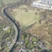
NS 6195 7262 An archaeological excavation in September 2001 within the factory confirmed the presence of the Cadder Roman military way at the site, although the remains had been truncated and disturbed by drainage systems and modern landscaping. The military way was 8.5m wide and the remains of a large ditch/drain approximately 1m wide was situated on the NE edge. There was evidence of flooding at the site and the surface of the road had been built up by at least 1m.
In addition, three earlier undated features were encountered: two linear channels and a curving slot trench. No archaeological artefacts were recovered during the fieldwork. (GUARD 1094).
Sponsor: Charles Scott & Partners
J Syme Duncan 2001.
NS 680 752 - NS 638 738 A watching brief was undertaken of site investigations in advance of construction of Stage 2 of the Kelvin Valley Sewer. Work involved numerous boreholes and test-pits along the proposed line of the sewer. No specific features of archaeological interest were noted but deep sequences of Holocene alluvial sediments were recorded.
A report has been lodged with West of Scotland Archaeology Service and the NMRS.
Sponsor: Wimtec Environmental for West of Scotland Water Authority.
S Carter 1998
NS 680 752 - NS 638 738 This report details the results of an archaeological evaluation undertaken in advance of temporary road access road construction for Stage 2, Phase 1 of the Kelvin Valley Sewer. Two of these access roads, 14 and 16, cross the Scheduled Monument designated for the line of the Antonine wall. As well as surveying the surviving archaeology, soil profiles were collected and a sediment study started. The main archaeological features discovered were the ditch and poorly preserved wall base of the Antonine Wall found beneath Access Road 16, and the Antonine ditch found beneath Access road 14. The wall and ditch are poorly preserved, evidence of intensive ploughing and cultivation were found and also evidence of stone robbing.
NMRS, MS/899/120.
NS67SW 45.01 627 728
A N-S strip, c.5m wide, was examined by the CFA prior to pipelaying. The kerbs of the stone base of the wall, here terraced into a N-facing slope, were lost; the core was of cobbles bonded by stiff clay. The ditch, which lay c.10m to the N, was c.6m wide and c.2.5m deep, with a steep-sided profile and a square bottom. Samples of peaty ditch-fill removed for pollen analysis seem likely to yield an important environmental record.
L J F Keppie 1993.
NS67SW 45.02 6195 7262
NS 6195 7262 An archaeological excavation in September 2001 within the factory confirmed the presence of the Cadder Roman military way at the site, although the remains had been truncated and disturbed by drainage systems and modern landscaping. The military way was 8.5m wide and the remains of a large ditch/drain approximately 1m wide was situated on the NE edge. There was evidence of flooding at the site and the surface of the road had been built up by at least 1m.
In addition, three earlier undated features were encountered: two linear channels and a curving slot trench. No archaeological artefacts were recovered during the fieldwork. (GUARD 1094).
Sponsor: Charles Scott & Partners
J Syme Duncan 2001.
Length from NS c. 63562 73004 to NS c. 64223 73575 scheduled with Roman fortlet (NS67SW 21), Roman temporary camp (NS67SW 24), and henge (NS67SW 27). Name cited as 'Antonine Wall, fortlet and camp 130m ESE to 930m NE of The Stables... a stretch about 880m long...'
[Index no, 7556: location map supplied].
Information from Historic Scotland, scheduling document dated 25 June 2010.
Length from NS c. 62374 72803 to NS c. 63401 72986 scheduled as 'Antonine Wall, 375m S of Hungryside to 55m NNE of Leafield... approximately 675m in length...'
[Index no. 7553: location map supplied].
Information from Historic Scotland, scheduling document dated 25 June 2010.
Length from NS c. 61804 72655 and NS c. 61939 72597 to NS c. 62356 72800 scheduled as 'Antonine Wall and Military Way, 515m N of Crofthead Cottage... approximately 575m in length...'
[Index no. 7551: location map supplied. See also ND67SW 45.03].
Information from Historic Scotland, scheduling document dated 31 March 2011.
Antiquarian Observation (1732)
NS 6081 7245 The Military Way and the Ditch are well preserved in Cawder Wood (Horsley 1732).
Antiquarian Observation (1793)
NS 6450 7375 to NS 6500 7393 Roy (1793) gives no position line here, and there are no recorded subsequent discoveries of the Wall or the Military Way.
Antiquarian Observation (1859)
NS 6217 7272 Slight remains of the Wall, much defaced in a strip of plantation. (Should read Military Way?) (ONB 1858).
Excavation (1913)
NS 6064 7245 The Wall base and turf superstructure were excavated at this point c. 1913 (Macdonald 1915).
Excavation (1913)
NS 6122 7260 to NS 6156 7256 The course of the Wall and Ditch were found by repeated excavations between the Lodge and the canal, about 1913 (Macdonald 1915).
Excavation (1913)
NS 6114 7259 The base of the Wall and the Military Way (at two points) were found by excavation about 1913 (Macdonald 1915).
Excavation (1913)
NS 6094 7251 The course of the Wall and alignment angle was determined by excavations on both sides of the road for a distance of over 100ft. about 1913. (Macdonald 1915).
Field Visit (1931 - 1932)
NS 6437 7370 A section of the Ditch was seen in the sand quarry near Adamslee in 1931-2. (A similar section, presumably in the same area, was seen in 1909) (Macdonald 1934).
Field Visit (1934)
NS 6300 7287 to NS 6356 7300 Remains of the Ditch are barely visible (Macdonald 1934).
Field Visit (1934)
NS 6450 7375 to NS 6500 7393 The line of the 'Limes' should run on a long ridge running WSW roughly parallel to the Glasgow Road which it overlooks (Macdonald 1934).
Aerial Photography (1 August 1946)
Aerial Photography (15 July 1947)
Aerial Photography (17 July 1955)
Aerial Photography (1 August 1957)
Aerial Photography (31 July 1957)
Field Visit (1957)
NS 6300 7287 to NS 6356 7300 The published survey (OS 25 inch 1958) was revised. No ground trace across smallholding on the E and then across arable field. Slight modifications on examination of extant line on the 1st edition of the OS 2 and a half inch map (Lanark 1897, sheet 1/8). OS Field Investigator noted no extant remains in 1957 (Information from OS 1957).
Field Visit (1957)
In 1957, the OS Field Investigator noted large stones in the bed of the Park Burn where the line crosses and also noted with negative results a modern cutting across the accepted line in the area of NS 6424 7366.
Excavation (1963)
NS 6000 7218 to NS 6001 7218 Four sections over a distance of 400ft. (continued from NS57SE 42.00 : NS 5996 7216 to NS 6000 7218) cut by the Ministry of Public Building Works prior to quarrying proved the Wall and Ditch are on the OS line in 1963 (Robertson 1966).
Excavation (1963)
NS 6026 7228 to NS 6040 7233 Five sections cut by the Ministry of Public Building Works in 1963 over a distance of 150m. On Cadder Golf Course confirmed the line of the Wall as shown by the OS (no locations given) (Robertson 1966).
Excavation (1963)
NS 6026 7228 to NS 6082 7250 Four sections cut by the Ministry of Public Building Works in 1963 over a distance of 600yds. On Cadder Golf Course confirmed the line of the Wall as shown by the OS (no locations given) (Robertson 1966).
Salvage Record (1966)
NS 603 723 The undercutting of a quarry face at the east end of the plantation (Robertson 1966) exposed sections of the rampart-base and of the upcast mound of the Wall. The rampart-base measured at least 4.6m across and had been laid in a construction-trench. The upcast mound was of orangey sand, covering the Roman turf-line, and measured c.18m wide.
L J F Keppie 1974; D R Wilson 1975.
Aerial Photography (29 July 1970)
Field Visit (1974)
NS 6152 7254 The base of the Wall was stated to be visible in disused quarry immediately W of Cadder fort (NS67SW 16) (Price 1974).
Salvage Record (1976)
NS 616 726 Observation of a pipe-line trench near the Forth and Clyde canal showed a deep build-up of earth. No trace of the stone base of the Antonine Wall was noted, but the S edge of the ditch was tentatively established.
S S Frere 1977; L J F Keppie 1976; A S Robertson 1966.
Salvage Record (1976)
NS 6155 7256 In 1976, excavations at a pipeline trench revealed no clear traces of the Wall or Ditch. This area was much disturbed (Keppie 1978).
Aerial Photography (21 July 1977)
Field Visit (1980)
NS 6300 7287 to NS 6356 7300 The published survey (OS 25 inch 1958) was revised. No ground trace across smallholding on the E and then across arable field. Slight modifications on examination of extant line on the 1st edition of the OS 2 and a half inch map (Lanark 1897, sheet 1/8). OS Field Investigator noted no extant remains in 1957 (Information from OS 1957).
Information from OS 1980
Aerial Photographic Transcription (1980)
NS 6419 7350 to NS 6424 7366 The published course (OS 50 inch 1967) was resurveyed. From NS 6419 7350 an amorphous hollow of the Ditch and an equally spread swelling of the Outer Mound is discernible in an arable field until it crosses Park Burn in which no surface trace is visible across the developed area. The line is shown extant the 2nd edition of the OS 2 and a half inch map (Stirlingshire 1898, sheet 33/5) and the new line is based on the re-examination of this and of RCAHMS aerial photographs (LA 1413-5 (1977) and LA 1486-7 (1977) which clearly shows the Ditch line.
There is no known report of the Rampart being uncovered, but the 2nd edition of the OS 2 and a half inch map does show it as intermittently extant. In 1957, the OS Field Investigator noted large stones in the bed of the Park Burn where the line crosses and also noted with negative results a modern cutting across the accepted line in the area of NS 6424 7366.
Aerial Photographic Transcription (1980)
NS 6400 7334 to NS 6419 7350 Resurvey based on surviving ground detail, the 2nd edition of the OS 2 and a half inch map (Stirlingshire 1898, sheet 33/5) which shows extant detail including the Rampart; and RCAHMS aerial photographs (LA 1431-15(1977) and LA 1486-87(1977)).
Aerial Photographic Transcription (1980)
NS 6356 7300 to NS 6400 7334 The published course (OS 25 inch 1969) was resurveyed. The amorphous hollow of the Ditch line is still occasionally visible across arable fields. The 1st edition of the OS 2 and a half inch map (Lanark 1897, sheet 1/8). Shows the line as fairly extant with the Outer Mound and Rampart surveyed in short lengths. The new line, including the two sharpened alignment angles, is also deduced from ground indications where possible, RAF vertical aerial photographs (F21/ 82/ 1236, frame no 0170-1, 1955) and RCAHMS aerial photographs (LA 1416 (1976), LA 2226-8 (1977)). CUCAP aerial photograph AGH54 also shows the line approaching Glasgow Bridge.
Aerial Photographic Transcription (1980)
NS 6200 7274 to NS 6300 7287 The published course (OS 25 inch 1957) was resurveyed. No extant of the Wall remains across arable fields, although the line of the Ditch can often be traced as a crop or soil mark, or amorphous hollow. The revised line is based on ground indications and re-examination of the 1st edition of the OS 2 and a half inch map (Lanark 1897, sheet 1/8) which shows the extant line; CUCAP aerial photographs Q30 and U52 confirm parts of the line as do RAF vertical aerial photographs (F22/ 58/ 1453, frame no 0329-30, 1956).
Aerial Photographic Transcription (1980)
NS 6082 7250 to NS 6100 7252 The published course (OS 25 inch 1957) was resurveyed. Macdonald's (1915) line is accepted; no surface trace is visible across the golf course. A soil mark consistent with the revised line is visible on RAF vertical aerial photographs (CPE/ SCOT/ 327, frame no 3037-8, 1948).
Aerial Photographic Transcription (1980)
NS 6000 7218 to NS 6026 7228 The published course (OS 25 inch 1957) was resurveyed. No remains exist across the disused quarry. The new line is deduced from the 1st edition OS 2 and a half map, revised detail around Buchley Lodge (see NS57SE 42.00 : NS 5983 7214 to NS 6000 7218 for details) and RAF vertical aerial photograph (F21/ 58/ 1453, frame no 0422, 1954). The evidence at NS 6001 7217 is somewhat contradictory, the text stating excavations proved the OS published line (the newline coincides here) while the scale plan from the hedge-line of Balmuildy Road pushed the line at an unacceptable distance to the N. It is assumed that the plan scale is in error. (However, see also NS57SE 42.00 : NS 5996 7216 ).
Field Visit (1980)
NS 6419 7350 to NS 6424 7366 The published course (OS 50 inch 1967) was resurveyed. From NS 6419 7350 an amorphous hollow of the Ditch and an equally spread swelling of the Outer Mound is discernible in an arable field until it crosses Park Burn in which no surface trace is visible across the developed area. The line is shown extant the 2nd edition of the OS 2 and a half inch map (Stirlingshire 1898, sheet 33/5) and the new line is based on the re-examination of this and of RCAHMS aerial photographs (LA 1413-5 (1977) and LA 1486-7 (1977) which clearly shows the Ditch line.
There is no known report of the Rampart being uncovered, but the 2nd edition of the OS 2 and a half inch map does show it as intermittently extant. In 1957, the OS Field Investigator noted large stones in the bed of the Park Burn where the line crosses and also noted with negative results a modern cutting across the accepted line in the area of NS 6424 7366.
Information from OS 1980
Field Visit (1980)
NS 6400 7334 to NS 6419 7350 Resurvey based on surviving ground detail, the 2nd edition of the OS 2 and a half inch map (Stirlingshire 1898, sheet 33/5) which shows extant detail including the Rampart; and RCAHMS aerial photographs (LA 1431-15(1977) and LA 1486-87(1977)).
Information from OS 1980
Field Visit (1980)
NS 6356 7300 to NS 6400 7334 The published course (OS 25 inch 1969) was resurveyed. The amorphous hollow of the Ditch line is still occasionally visible across arable fields. The 1st edition of the OS 2 and a half inch map (Lanark 1897, sheet 1/8). Shows the line as fairly extant with the Outer Mound and Rampart surveyed in short lengths. The new line, including the two sharpened alignment angles, is also deduced from ground indications where possible, RAF vertical aerial photographs (F21/ 82/ 1236, frame no 0170-1, 1955) and RCAHMS aerial photographs (LA 1416 (1976), LA 2226-8 (1977)). CUCAP aerial photograph AGH54 also shows the line approaching Glasgow Bridge.
Information from OS 1980
Field Visit (1980)
NS 6200 7274 to NS 6300 7287 The published course (OS 25 inch 1957) was resurveyed. No extant of the Wall remains across arable fields, although the line of the Ditch can often be traced as a crop or soil mark, or amorphous hollow. The revised line is based on ground indications and re-examination of the 1st edition of the OS 2 and a half inch map (Lanark 1897, sheet 1/8) which shows the extant line; CUCAP aerial photographs Q30 and U52 confirm parts of the line as do RAF vertical aerial photographs (F22/ 58/ 1453, frame no 0329-30, 1956).
Information from OS 1980
Field Visit (1980)
NS 6082 7250 to NS 6100 7252 The published course (OS 25 inch 1957) was resurveyed. Macdonald's (1915) line is accepted; no surface trace is visible across the golf course. A soil mark consistent with the revised line is visible on RAF vertical aerial photographs (CPE/ SCOT/ 327, frame no 3037-8, 1948).
Information from OS 1980
Field Visit (1980)
NS 6000 7218 to NS 6026 7228 The published course (OS 25 inch 1957) was resurveyed. No remains exist across the disused quarry. The new line is deduced from the 1st edition OS 2 and a half map, revised detail around Buchley Lodge (see NS57SE 42.00 : NS 5983 7214 to NS 6000 7218 for details) and RAF vertical aerial photograph (F21/ 58/ 1453, frame no 0422, 1954). The evidence at NS 6001 7217 is somewhat contradictory, the text stating excavations proved the OS published line (the newline coincides here) while the scale plan from the hedge-line of Balmuildy Road pushed the line at an unacceptable distance to the N. It is assumed that the plan scale is in error. (However, see also NS57SE 42.00 : NS 5996 7216 ).
Information from OS 1980
Field Visit (1980)
NS 6450 7375 to NS 6500 7393 The published survey (OS 50 inch 1966) was deleted. The OS course based in Macdonald's (1934) conjectural line marked on Record 25 inch is no longer tenable. Excavations of the Wall at Peel Park (see NS67SE 42.00 : NS 6506 7396, NS 6507 7400, NS 6522 7405, NS 6525 7405, and NS 6532 7408) show that a markedly different alignment, as yet undetermined through this sector, may exist, although the severe quarrying and landscaping in this area may preclude it ever being located.
Information from OS 1980
Field Visit (1980)
NS 6439 7370 to NS 6450 7373 The published survey (OS 50 inch 1967) was deleted. Macdonald's (and OS) line is probably inaccurate E of Adamslee, given the excavation evidence at Peel Park (see NS67SE 42.00 : NS 6506 7396, NS 6507 7400, NS 6522 7405, NS 6525 7405, and NS 6532 7408 ). No large scale survey can be laid down with any degree of accuracy.
Information from OS 1980
Field Visit (1980)
NS 6100 7252 to NS 6200 7274 The published course (OS 25 inch 1958) was resurveyed. There are no surface remains; Macdonald's (1915) line has been generally accepted. Alignment angles have been sharpened and all are feasible on topographic and sighting grounds. The unlikely rounded curve at the Lodge has been straightened.
Information from OS 1980
Field Visit (1980)
The published course (OS 25 inch 1957) was resurveyed. Apart from one isolated well-defined length of the Ditch, at NS 6026 7228 to NS 6029 7230, which is up to 12m wide and about 2m deep, only a vague hollow of the Ditch line is visible bounding and crossing a golf course. Evidence at NS 6064 7245 and at the five sections located at NS 6027 7227, NS 6028 7228, NS 6037 7232, NS 6039 7232 and NS 6040 7233 confirms the extant 1st edition OS 2 and a half map survey of the Wall, Ditch and Outer Mound. The revised line with its definite alignment angles is deduced from ground indications and the 1st edition of the OS 2 and a half inch map (Lanark 1897, sheet 1/7 and 1/11). The five overgrown but open sections on the Wall line over a total distance of some 150m were verified. These are apparently unpublished, but were marked anonymously on a record OS 25 inch sheet in 1965. It must be assumed pending further inquiry that they form part of or are subsequent to the excavations on Cadder Golf Course (see Robertson 1966) although there are obvious discrepancies in account.
Information from OS 1980
Field Visit (1980)
NS 6424 7366 to NS 6439 7370 The published survey (OS 50 inch 1967) was revised. Macdonald's (1934) line is accepted. No surface traces across developed area. The alignment angle at NS 6424 7366 remains unchanged - optimum sighting and change of slope position.
Information from OS 1980
Measured Survey (1980)
NS 6400 7334 to NS 6419 7350 The published course (OS 25 inch 1969) was resurveyed. Only an amorphous hollow of the Ditch and the equally spread swelling of the Outer Mound survive in arable fields. There is no trace of the Rampart.
Information from OS 1980
Excavation (October 1992 - October 1992)
NS 6274 7284 Excavation in advance of the construction of a water pipe-line found the stone base of the Rampart was partially preserved as a band of cobbles and boulders up to 2.8m wide. No kerbstones were identified. The stone base was bonded and overlain in places by a stiff, pink clay. Very little of the body of the Rampart was preserved in situ - a few individual turfs, recognizable as alternating lamination of dark, humic soil and light grey silty soil, lay within an immediately upon the pink foundation clay. The maximum preserved height of the Rampart was 0.25m.
The Ditch lay c.7.8m to the N of the Rampart remains. It was c.5.8m wide at its surface and attained a maximum depth of c.2.5m, slightly narrower than expected. Its sides sloped down steeply to a squared basal channel measuring c.0.6m wide and c.0.4m deep. Immediately to either side of the Ditch the ground sloped downwards gently towards it, most probable as a result of erosion of subsoil into the Ditch from either side. The uppermost Ditch fills also occupied this wider hollow. The exposure of these deposits following topsoiling initially suggested the Ditch to have a surface width of at least 10m.
The width of the berm can only be estimated due to truncation of the Rampart and erosion of the Ditch to be c. 7m-8m wide.
Palynological evidence from the organic fill of the Ditch has yielded a detailed picture of vegetation change spanning c.600 years immediately post-dating the construction of the Wall.
No structural remains of the Outer Mound were preserved, however, its position appears to have been fossilized as a subsoil impression.
No certain trace of the Military Way was identified. A flat-bottomed ditch identified at the S end of the trench , c.15m S of the Rampart, may be the remains of a ditch flanking this road, although alternatively the feature may be a field boundary or drainage feature of comparatively recent origin.
A Dunwell and G Coles 1998
Excavation (1993)
NS67SW 45.01 627 728
A N-S strip, c.5m wide, was examined by the CFA prior to pipelaying. The kerbs of the stone base of the wall, here terraced into a N-facing slope, were lost; the core was of cobbles bonded by stiff clay. The ditch, which lay c.10m to the N, was c.6m wide and c.2.5m deep, with a steep-sided profile and a square bottom. Samples of peaty ditch-fill removed for pollen analysis seem likely to yield an important environmental record.
L J F Keppie 1993.
Excavation (31 October 1994 - 30 November 1994)
NS 6190 7270 Archaeological recording of a section in November 1994 through the Antonine Wall at this spot revealed a well preserved construction sequence through the wall base. The berm and ditch, although affected, were not available for recording.
NMRS MS/725/98.
NS 619 727 The recording of a section exposed in the course of an unauthorised cut across the Wall 200m E of Cadder fort (NS67SW 16) revealed the N half of the stone base edged by a kerbstone, with turf superstructure surviving to a height of 0.5m.
L J F Keppie 1996.
Watching Brief (1998)
NS 680 752 - NS 638 738 A watching brief was undertaken of site investigations in advance of construction of Stage 2 of the Kelvin Valley Sewer. Work involved numerous boreholes and test-pits along the proposed line of the sewer. No specific features of archaeological interest were noted but deep sequences of Holocene alluvial sediments were recorded.
A report has been lodged with West of Scotland Archaeology Service and the NMRS.
Sponsor: Wimtec Environmental for West of Scotland Water Authority.
S Carter 1998
Excavation (September 2001 - September 2001)
NS67SW 45.02 6195 7262
NS 6195 7262 An archaeological excavation in September 2001 within the factory confirmed the presence of the Cadder Roman military way at the site, although the remains had been truncated and disturbed by drainage systems and modern landscaping. The military way was 8.5m wide and the remains of a large ditch/drain approximately 1m wide was situated on the NE edge. There was evidence of flooding at the site and the surface of the road had been built up by at least 1m.
In addition, three earlier undated features were encountered: two linear channels and a curving slot trench. No archaeological artefacts were recovered during the fieldwork. (GUARD 1094).
Sponsor: Charles Scott & Partners
J Syme Duncan 2001.
Publication Account (2002)
NS 6190 7270 In November 1994 a short emergency recording exercise was undertaken by GUARD on a section through the Antonine Wall near the site of the fort at Cadder (Clarke 1933), after a trench some 14m wide had been cut through the scheduled monument without prior consent. The trench had been partially backfilled before the arrival of the archaeologists, allowing only the W-facing section to be recorded.
The trench had been cut into the natural subsoils, leaving no trace of the Wall on plan. Cleaning of the section face revealed part of the base of the Rampart in the form of a layer of cobbles. A clear kerb-stone was located at the N end. The cobble spread was no more than 1.5m wide, in contrast to the more usual Rampart base width of 4m to 5m. The exposed section did not extend far enough to the N to locate the position of the Ditch.
K Speller and A Leslie 2002
A Dunwell, G Bailey, A Leslie, A Smith 2002; J Clarke 1933.
Project (4 February 2008 - 15 February 2008)
The Antonine Ditch has been clearly detected by both survey techniques; the magnetic response is generally uniform across the site while the resistance anomalies vary, depending on localised natural factors. Evidence for the Rampart is more tentative and intermittent, though at their most coherent, the magnetic responses suggest a partially intact base constructed of highly magnetic cobbles. The Military Way remains elusive; though a few faint trends have been identified which might represent the line of the road, natural and modern agricultural factors make this interpretation highly inconclusive. The ditches of the fortlet appear in both datasets but no obvious internal features have been detected. No anomalies that can be obviously attributed to postulated Rampart towers have been identified; the nature of these features makes them very difficult to detect by either technique, thus an absence of geophysical evidence cannot prove or disprove their presence along the Antonine Wall.
OASIS ID: gsbprosp1-43972
Magnetometry (4 February 2008 - 15 February 2008)
Magnetometry survey.
OASIS ID: gsbprosp1-43972.
Earth Resistance Survey (4 February 2008 - 15 February 2008)
Resistance survey.
OASIS ID: gsbprosp1-43972.
Earth Resistance Survey (4 February 2008 - 15 February 2008)
Earth Resistance survey.
OASIS ID: gsbprosp1-43972
Magnetometry (4 February 2008 - 15 February 2008)
Magnetometry survey.
OASIS ID: gsbprosp1-43972
Magnetometry (4 February 2008 - 15 February 2008)
Project (4 February 2008 - 15 February 2008)
A series of geophysical survey techniques were employed to identify and accurately locate the Antonine Wall, any traces of the Military Way and the fortlet at Glasgow Bridge and to identify any other features which might be associated with the fortlet or the Wall. In particular it was hoped that a large scale magnetic survey across an uninterrupted stretch might prove useful in assessing whether towers/turrets were present along the line of the Rampart. The workforms part of a continuing programme of research commissioned by Historic Scotland, as part of their proposal to promote the Antonine Wall to World Heritage Status.
The Antonine Ditch has been clearly detected by both survey techniques; the magnetic response is generally uniform across the site while the resistance anomalies vary, depending on localised natural factors. Evidence for the Rampart is more tentative and intermittent, though at their most coherent, the magnetic responses suggest a partially intact base constructed of highly magnetic cobbles. The Military Way remains elusive; though a few faint trends have been identified which might represent the line of the road, natural and modern agricultural factors make this interpretation highly inconclusive. The ditches of the fortlet appear in both datasets but no obvious internal features have been detected. No anomalies that can be obviously attributed to postulated Rampart towers have been identified; the nature of these features makes them very difficult to detect by either technique, thus an absence of geophysical evidence cannot prove or disprove their presence along the Antonine Wall.
OASIS ID: gsbprosp1-43972.
Magnetometry (10 November 2008 - 14 November 2008)
The study area was surveyed twice with the gradiometer: in the first data set (Area 1) the traverses run perpendicular to the Wall, in the second (Area 2) they are aligned parallel with it. The results show only a marginal change in definition of the Ditch, but a slightly greater impact on the
Rampart, with Area 1 producing the more coherent responses. Anomalies perpendicular to the wall were better defined in Area 2. By processing the Area 2 data it has been possible to remove the visually prevalent Ditch and Rampart anomalies and isolate a few smaller scale non-linear responses. However, assessing the archaeological significance of these responses remains problematic due to the naturally high magnetic background and the usefulness of this approach in identifying postulated towers is unproven.
Responses from modern cultivation visually dominate the resistance data. Sections of Rampart appear as relatively well defined high resistance anomalies while the Ditch has produced only intermittent and somewhat ill defined high resistance bands. It appears that the high ground and relatively good drainage has enhanced the ploughing trend while reducing the moisture contrast between the Ditch fill and the surrounding soil. Overall, however, the resistance survey has added little to the assessment of the site.
C. Stephens
Earth Resistance Survey (10 November 2008 - 14 November 2008)
The study area was surveyed twice with the gradiometer: in the first data set (Area 1) the traverses run perpendicular to the Wall, in the second (Area 2) they are aligned parallel with it. The results show only a marginal change in definition of the Ditch, but a slightly greater impact on the
Rampart, with Area 1 producing the more coherent responses. Anomalies perpendicular to the wall were better defined in Area 2. By processing the Area 2 data it has been possible to remove the visually prevalent Ditch and Rampart anomalies and isolate a few smaller scale non-linear responses. However, assessing the archaeological significance of these responses remains problematic due to the naturally high magnetic background and the usefulness of this approach in identifying postulated towers is unproven.
Responses from modern cultivation visually dominate the resistance data. Sections of Rampart appear as relatively well defined high resistance anomalies while the Ditch has produced only intermittent and somewhat ill defined high resistance bands. It appears that the high ground and relatively good drainage has enhanced the ploughing trend while reducing the moisture contrast between the Ditch fill and the surrounding soil. Overall, however, the resistance survey has added little to the assessment of the site.
C. Stephens
Aerial Photography

