Aerial Photographic Transcription


Date 1980
Event ID 560461
Category Recording
Type Aerial Photographic Transcription
Permalink http://canmore.org.uk/event/560461
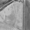
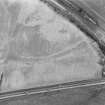
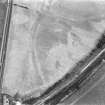
NS 6356 7300 to NS 6400 7334 The published course (OS 25 inch 1969) was resurveyed. The amorphous hollow of the Ditch line is still occasionally visible across arable fields. The 1st edition of the OS 2 and a half inch map (Lanark 1897, sheet 1/8). Shows the line as fairly extant with the Outer Mound and Rampart surveyed in short lengths. The new line, including the two sharpened alignment angles, is also deduced from ground indications where possible, RAF vertical aerial photographs (F21/ 82/ 1236, frame no 0170-1, 1955) and RCAHMS aerial photographs (LA 1416 (1976), LA 2226-8 (1977)). CUCAP aerial photograph AGH54 also shows the line approaching Glasgow Bridge.