Aerial Photographic Transcription


Date 1980
Event ID 560463
Category Recording
Type Aerial Photographic Transcription
Permalink http://canmore.org.uk/event/560463
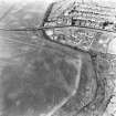
NS 6419 7350 to NS 6424 7366 The published course (OS 50 inch 1967) was resurveyed. From NS 6419 7350 an amorphous hollow of the Ditch and an equally spread swelling of the Outer Mound is discernible in an arable field until it crosses Park Burn in which no surface trace is visible across the developed area. The line is shown extant the 2nd edition of the OS 2 and a half inch map (Stirlingshire 1898, sheet 33/5) and the new line is based on the re-examination of this and of RCAHMS aerial photographs (LA 1413-5 (1977) and LA 1486-7 (1977) which clearly shows the Ditch line.
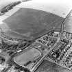
There is no known report of the Rampart being uncovered, but the 2nd edition of the OS 2 and a half inch map does show it as intermittently extant. In 1957, the OS Field Investigator noted large stones in the bed of the Park Burn where the line crosses and also noted with negative results a modern cutting across the accepted line in the area of NS 6424 7366.