
Following the launch of trove.scot in February 2025 we are now planning the retiral of some of our webservices. Canmore will be switched off on 24th June 2025. Information about the closure can be found on the HES website: Retiral of HES web services | Historic Environment Scotland
Ordnance Survey Archaeology Division Revision Programme


Date 1947 - 31 March 1983
Event ID 1014509
Category Project
Type Project
Permalink http://canmore.org.uk/event/1014509
The programme of the Ordnance Survey’s Archaeology Division (c.1947-1983) was created to provide information regarding archaeological sites to be published on Ordnance Survey maps (Philips 1960; Seymour 1980: 240, 340-343; Frodsham, Topping and Cowley (eds) 1999).
Having opened an Edinburgh office on 1 October 1958 (DES 1958, 41), and an Inverness office from 1964 (DES 1964, 58), the Division in Scotland published a brief summary of their progress annually in Discovery and Excavation in Scotland for 25 years. The responsibilities of the Archaeology Division in Scotland and the records of their work were transferred to RCAHMS on 1 April 1983 (DES 1983, 53; RCAHMS 1984: ix).
The main product of this programme consists of more than 55,000 record cards organised by 100km squares of the National Grid, recording c.36,000 sites, monuments or findspots. Each received its own card or cards arranged in a National Grid numbering sequence. The original record cards have now been digitised and are linked to each site record.
The data gathered included a summary description written by an OS Recorder and based on published sources (akin to a basic desk-based assessment), often quoting at length from authoritative sources. To this was appended an account of its state at the time of the OS Investigator’s field visit or visits.
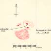
Where appropriate a detailed sketch was added and one or more photographs of a quality good enough to aid identification. A secondary record of each site was kept on a complete set of c.3,800 maps at 1:10,000 or 1:10,560 scale on which every feature or find was noted as it became known (Seymour 1980: 342). Such was the utility of the dataset (essentially created for OS internal use) that it was shared widely with other organisations at a national and local level, although the original was maintained and curated by the OS and later RCAHMS. This ended in 1990, when the entry of most of the information into a digital database was completed, and the text became available through Canmore.
Information from HES Survey and Recording (GFG) October 2016


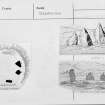
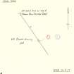
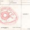
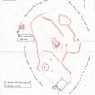
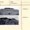
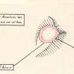
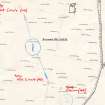
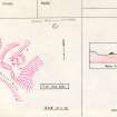
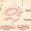
SC 923642
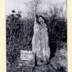
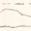
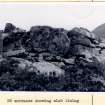
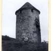
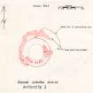
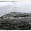
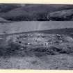
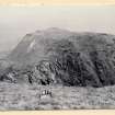
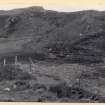
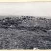
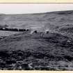
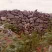
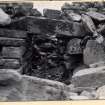
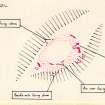
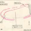
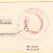
Copy of complete OS card with copies of 3 drawings: plan and two general views.
Records of the Ordnance Survey, Southampton, Hampshire, England
1975
© Crown Copyright: HES (Ordnance Survey Archaeology Division)

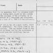
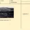
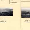
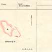
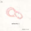
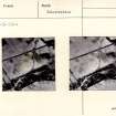
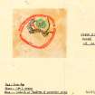
SC 923645
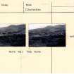
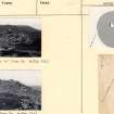
Copy of complete OS card with written details.
Records of the Ordnance Survey, Southampton, Hampshire, England
1975
© Crown Copyright: HES (Ordnance Survey Archaeology Division)

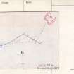
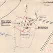
DP 207928
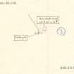
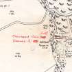
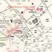
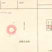
Ordnance Survey Archaeology Division Record Sheet, preparatory map of archaeological sites.
Records of the Royal Commission on the Ancient and Historical Monuments of Scotland (RCAHMS), Edinbu
2/6/1966
© Crown Copyright: HES

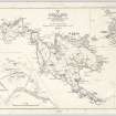
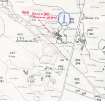
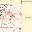
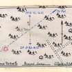
DP 207929
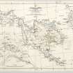
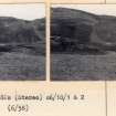
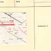
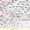
Map of St Kilda or Hirta and adjacent islands and stacs (1963). Annotated with position of antiquities noted on original.
Records of the Royal Commission on the Ancient and Historical Monuments of Scotland (RCAHMS), Edinbu
c. 1966
© Crown Copyright: HES

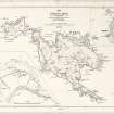
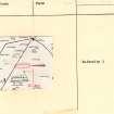
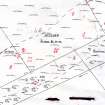
DP 207930
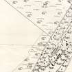
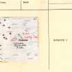
Ordnance Survey Archaeology Division Field Sheet. Updated with positions and information of archaeological sites.
Records of the Royal Commission on the Ancient and Historical Monuments of Scotland (RCAHMS), Edinbu
c. 1967
© Crown Copyright: HES

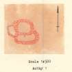
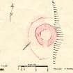
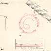
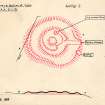
SC 1473052
Plan, copied from OS '495' card
Records of the Ordnance Survey, Southampton, Hampshire, England
7/1961
© Crown Copyright: HES (Ordnance Survey Archaeology Division)

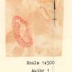
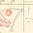
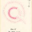
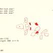
SC 1523475
Plan, copied from OS '495' card
Records of the Ordnance Survey, Southampton, Hampshire, England
16/6/1967
© Crown Copyright: HES (Ordnance Survey Archaeology Division)

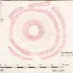
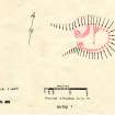
SC 1536001
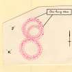
Plan, copied from '495' card
Records of the Ordnance Survey, Southampton, Hampshire, England
6/11/1978
© Crown Copyright: HES (Ordnance Survey Archaeology Division)

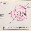
SC 1536002
Plan, copied from '495' card
Records of the Ordnance Survey, Southampton, Hampshire, England
21/4/1960
© Crown Copyright: HES (Ordnance Survey Archaeology Division)

SC 1536003
Plan, copied from '495' card
Records of the Ordnance Survey, Southampton, Hampshire, England
14/9/1977
© Crown Copyright: HES (Ordnance Survey Archaeology Division)

SC 1541762
OS '495' illustration card
Records of the Ordnance Survey, Southampton, Hampshire, England
23/5/1961
© Crown Copyright: HES (Ordnance Survey Archaeology Division)

SC 1541763
OS '495' illustration card
Records of the Ordnance Survey, Southampton, Hampshire, England
22/5/1961
© Crown Copyright: HES (Ordnance Survey Archaeology Division)

SC 1541765
Plan, copied from OS '495' card
Records of the Ordnance Survey, Southampton, Hampshire, England
20/11/1975
© Crown Copyright: HES (Ordnance Survey Archaeology Division)

SC 1541766
Plan, copied from OS '495' Illustration card
Records of the Ordnance Survey, Southampton, Hampshire, England
19/2/1976
© Crown Copyright: HES (Ordnance Survey Archaeology Division)

SC 1541767
Plan of 'A', copied from OS '495' Illustration card
Records of the Ordnance Survey, Southampton, Hampshire, England
12/2/1976
© Crown Copyright: HES (Ordnance Survey Archaeology Division)

SC 1541768
OS '495' Illustration card showing original plan by OS (28 August 1975), copy of published plan by RCAHMS (1911) and original OS photograph (7 April 1962)
Records of the Ordnance Survey, Southampton, Hampshire, England
c. 1975
© Crown Copyright: HES (Ordnance Survey Archaeology Division)

SC 1541769
OS '495' Illustration card
Records of the Ordnance Survey, Southampton, Hampshire, England
28/4/1964
© Crown Copyright: HES (Ordnance Survey Archaeology Division)

SC 1541836
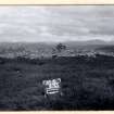
Photograph, copied from OS '495' card
Records of the Ordnance Survey, Southampton, Hampshire, England
4/4/1962
© Crown Copyright: HES (Ordnance Survey Archaeology Division)

SC 1541837
Plan, copied from OS '495' card
Records of the Ordnance Survey, Southampton, Hampshire, England
26/8/1975
© Crown Copyright: HES (Ordnance Survey Archaeology Division)

SC 1541838
Photograph, copied from OS '495' card
Records of the Ordnance Survey, Southampton, Hampshire, England
7/4/1962
© Crown Copyright: HES (Ordnance Survey Archaeology Division)

SC 1541839
Photographs, copied from OS '495' card
Records of the Ordnance Survey, Southampton, Hampshire, England
7/4/1962
© Crown Copyright: HES (Ordnance Survey Archaeology Division)

SC 1541840
Photographs, copied from OS '495' card
Records of the Ordnance Survey, Southampton, Hampshire, England
7/4/1962
© Crown Copyright: HES (Ordnance Survey Archaeology Division)

SC 1541851
Plan, copied from OS '495' card
Records of the Ordnance Survey, Southampton, Hampshire, England
8/1/1976
© Crown Copyright: HES (Ordnance Survey Archaeology Division)

SC 1541852
Plan, copied from OS '495' card
Records of the Ordnance Survey, Southampton, Hampshire, England
28/10/1975
© Crown Copyright: HES (Ordnance Survey Archaeology Division)

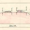
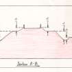
SC 1541853
Section, copied from OS '495' card
Records of the Ordnance Survey, Southampton, Hampshire, England
10/1975
© Crown Copyright: HES (Ordnance Survey Archaeology Division)

SC 1541854
Plan, copied from OS '495' card
Records of the Ordnance Survey, Southampton, Hampshire, England
29/10/1975
© Crown Copyright: HES (Ordnance Survey Archaeology Division)

SC 1541855
Photograph, copied from OS '495' card
Records of the Ordnance Survey, Southampton, Hampshire, England
31/1/1966
© Crown Copyright: HES (Ordnance Survey Archaeology Division)

SC 1542074
Photograph, copied from OS '495' card
Records of the Ordnance Survey, Southampton, Hampshire, England
16/7/1961
© Crown Copyright: HES (Ordnance Survey Archaeology Division)

SC 1542075
Photograph, copied from OS '495' card
Records of the Ordnance Survey, Southampton, Hampshire, England
17/7/1961
© Crown Copyright: HES (Ordnance Survey Archaeology Division)

SC 1542076
Plan, copied from OS '495' card
Records of the Ordnance Survey, Southampton, Hampshire, England
18/8/1975
© Crown Copyright: HES (Ordnance Survey Archaeology Division)

SC 1542077
Photograph, copied from OS '495' card
Records of the Ordnance Survey, Southampton, Hampshire, England
13/7/1961
© Crown Copyright: HES (Ordnance Survey Archaeology Division)

SC 1542078
Photograph, copied from OS '495' card
Records of the Ordnance Survey, Southampton, Hampshire, England
10/5/1960
© Crown Copyright: HES (Ordnance Survey Archaeology Division)

SC 1542079
Plan, copied from OS '495' card
Records of the Ordnance Survey, Southampton, Hampshire, England
30/6/1977
© Crown Copyright: HES (Ordnance Survey Archaeology Division)

SC 1542080
Plan, copied from OS '495' card
Records of the Ordnance Survey, Southampton, Hampshire, England
1/7/1977
© Crown Copyright: HES (Ordnance Survey Archaeology Division)

SC 1542081
Plan, copied from OS '495' card
Records of the Ordnance Survey, Southampton, Hampshire, England
3/11/1975
© Crown Copyright: HES (Ordnance Survey Archaeology Division)

SC 1542082
Photograph, copied from OS '495' card
Records of the Ordnance Survey, Southampton, Hampshire, England
24/4/1964
© Crown Copyright: HES (Ordnance Survey Archaeology Division)

SC 1542083
Plan, copied from OS '495' card
Records of the Ordnance Survey, Southampton, Hampshire, England
26/4/1964
© Crown Copyright: HES (Ordnance Survey Archaeology Division)

SC 1542084
Section, copied from OS '495' card
Records of the Ordnance Survey, Southampton, Hampshire, England
27/10/1975
© Crown Copyright: HES (Ordnance Survey Archaeology Division)

SC 1542085
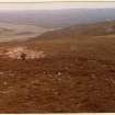
Photograph of hut circle, copied from OS '495' card
Records of the Ordnance Survey, Southampton, Hampshire, England
26/4/1964
© Crown Copyright: HES (Ordnance Survey Archaeology Division)

SC 1542091
Photograph, copied from OS '495' card
Records of the Ordnance Survey, Southampton, Hampshire, England
27/7/1960
© Crown Copyright: HES (Ordnance Survey Archaeology Division)

SC 1542092
Photograph, copied from OS '495' card
Records of the Ordnance Survey, Southampton, Hampshire, England
28/4/1960
© Crown Copyright: HES (Ordnance Survey Archaeology Division)

SC 1542093
Photograph, copied from OS '495' card
Records of the Ordnance Survey, Southampton, Hampshire, England
27/4/1960
© Crown Copyright: HES (Ordnance Survey Archaeology Division)

SC 1542094
Photograph, copied from OS '495' card
Records of the Ordnance Survey, Southampton, Hampshire, England
27/4/1960
© Crown Copyright: HES (Ordnance Survey Archaeology Division)

SC 1542095
Photograph, copied from OS '495' card
Records of the Ordnance Survey, Southampton, Hampshire, England
13/6/1960
© Crown Copyright: HES (Ordnance Survey Archaeology Division)

SC 1542096
OS '495' card showing survey details
Records of the Ordnance Survey, Southampton, Hampshire, England
7/1971
© Crown Copyright: HES (Ordnance Survey Archaeology Division)

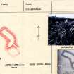
SC 1542097
OS '495' illustration card showing photographs (OS, 27 April 1960), divorced survey (OS, 8 July 1971) and plan (Henshall, 1963)
Records of the Ordnance Survey, Southampton, Hampshire, England
1960
© Crown Copyright: HES (Ordnance Survey Archaeology Division)

SC 1542114
Plan, copied from OS '495' card
Records of the Ordnance Survey, Southampton, Hampshire, England
16/12/1978
© Crown Copyright: HES (Ordnance Survey Archaeology Division)

SC 1542115
Plan, copied from OS '495' card
Records of the Ordnance Survey, Southampton, Hampshire, England
15/12/1978
© Crown Copyright: HES (Ordnance Survey Archaeology Division)

SC 1542116
Divorced survey, copied from OS '495' card
Records of the Ordnance Survey, Southampton, Hampshire, England
7/7/1971
© Crown Copyright: HES (Ordnance Survey Archaeology Division)

SC 1542118
Plan, copied from OS '495' card
Records of the Ordnance Survey, Southampton, Hampshire, England
16/12/1978
© Crown Copyright: HES (Ordnance Survey Archaeology Division)

SC 1542119
Photograph, copied from OS '495' card
Records of the Ordnance Survey, Southampton, Hampshire, England
6/5/1960
© Crown Copyright: HES (Ordnance Survey Archaeology Division)

SC 1542120
Photograph, copied from OS '495' card
Records of the Ordnance Survey, Southampton, Hampshire, England
6/5/1960
© Crown Copyright: HES (Ordnance Survey Archaeology Division)

SC 1542121
Plan, copied from OS '495' card
Records of the Ordnance Survey, Southampton, Hampshire, England
8/12/1978
© Crown Copyright: HES (Ordnance Survey Archaeology Division)

SC 1542263
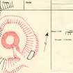
Plan of Cairn 'C', copied from OS '495' card
Records of the Ordnance Survey, Southampton, Hampshire, England
17/12/1978
© Crown Copyright: HES (Ordnance Survey Archaeology Division)

SC 1542264
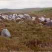
Photograph, copied from OS '495' card. Cairn 'C' from NW
Records of the Ordnance Survey, Southampton, Hampshire, England
18/12/1978
© Crown Copyright: HES (Ordnance Survey Archaeology Division)

SC 1542265
Photograph, copied from OS '495' card. Cairn 'B' - interior from E showing recent wall face
Records of the Ordnance Survey, Southampton, Hampshire, England
18/12/1978
© Crown Copyright: HES (Ordnance Survey Archaeology Division)

SC 1542266
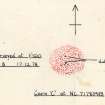
Plan and photograph, copied from OS '495' card
Records of the Ordnance Survey, Southampton, Hampshire, England
1977
© Crown Copyright: HES (Ordnance Survey Archaeology Division)

SC 1542267
Photograph, copied from OS '495' card. Detail of inner end of passage.
Records of the Ordnance Survey, Southampton, Hampshire, England
1/9/1977
© Crown Copyright: HES (Ordnance Survey Archaeology Division)

SC 1542268
Plan, copied from OS '495' card
Records of the Ordnance Survey, Southampton, Hampshire, England
25/8/1977
© Crown Copyright: HES (Ordnance Survey Archaeology Division)

SC 1542269
Photograph, copied from OS '495' card
Records of the Ordnance Survey, Southampton, Hampshire, England
11/12/1978
© Crown Copyright: HES (Ordnance Survey Archaeology Division)

SC 1542270
Photograph, copied from OS '495' card
Records of the Ordnance Survey, Southampton, Hampshire, England
3/5/1960
© Crown Copyright: HES (Ordnance Survey Archaeology Division)

SC 1542271
Plan, copied from OS '495' card
Records of the Ordnance Survey, Southampton, Hampshire, England
8/8/1977
© Crown Copyright: HES (Ordnance Survey Archaeology Division)

SC 1542471
Photograph, copied from OS '495' card
Records of the Ordnance Survey, Southampton, Hampshire, England
3/5/1960
© Crown Copyright: HES (Ordnance Survey Archaeology Division)

SC 1542477
Photograph, copied from OS '495' card
Records of the Ordnance Survey, Southampton, Hampshire, England
3/5/1960
© Crown Copyright: HES (Ordnance Survey Archaeology Division)

SC 1542478
Photograph, copied from OS '495' card
Records of the Ordnance Survey, Southampton, Hampshire, England
3/5/1960
© Crown Copyright: HES (Ordnance Survey Archaeology Division)

SC 1542484
Photograph, copied from OS '495' card
Records of the Ordnance Survey, Southampton, Hampshire, England
1960
© Crown Copyright: HES (Ordnance Survey Archaeology Division)

SC 1542485
Photograph, copied from OS '495' card
Records of the Ordnance Survey, Southampton, Hampshire, England
c. 1960
© Crown Copyright: HES (Ordnance Survey Archaeology Division)

SC 1544962
Photograph, copied from OS '495' card
Records of the Ordnance Survey, Southampton, Hampshire, England
25/4/1960
© Crown Copyright: HES (Ordnance Survey Archaeology Division)

SC 1544963
Photograph, copied from OS '495' card
Records of the Ordnance Survey, Southampton, Hampshire, England
25/4/1960
© Crown Copyright: HES (Ordnance Survey Archaeology Division)

SC 1544964
Photograph, copied from 495 card
Records of the Ordnance Survey, Southampton, Hampshire, England
22/6/1960
© Crown Copyright: HES (Ordnance Survey Archaeology Division)

SC 1544965
Photograph, copied from 495 card
Records of the Ordnance Survey, Southampton, Hampshire, England
22/6/1960
© Crown Copyright: HES (Ordnance Survey Archaeology Division)

SC 1547243
Map revision, copied from record card
Records of the Ordnance Survey, Southampton, Hampshire, England
17/5/1966
© Crown Copyright: HES (Ordnance Survey Archaeology Division)

SC 1547244
Plan, copied from record card
Records of the Ordnance Survey, Southampton, Hampshire, England
3/12/1970
© Crown Copyright: HES (Ordnance Survey Archaeology Division)

SC 1547245
Map revision, copied from record card
Records of the Ordnance Survey, Southampton, Hampshire, England
8/3/1966
© Crown Copyright: HES (Ordnance Survey Archaeology Division)

SC 1547246
Plan, copied from record card
Records of the Ordnance Survey, Southampton, Hampshire, England
27/11/1970
© Crown Copyright: HES (Ordnance Survey Archaeology Division)

SC 1547262
Air photographs, copied from record card
Records of the Ordnance Survey, Southampton, Hampshire, England
1966
© Crown Copyright: HES (Ordnance Survey Archaeology Division)

SC 1547263
Map revision, copied from record card
Records of the Ordnance Survey, Southampton, Hampshire, England
19/1/1966
© Crown Copyright: HES (Ordnance Survey Archaeology Division)

SC 1547264
Map revision, copied from record card
Records of the Ordnance Survey, Southampton, Hampshire, England
19/1/1966
© Crown Copyright: HES (Ordnance Survey Archaeology Division)

SC 1547265
Map revision, copied from record card
Records of the Ordnance Survey, Southampton, Hampshire, England
20/1/1966
© Crown Copyright: HES (Ordnance Survey Archaeology Division)

SC 1547266
Map revision, copied from record card
Records of the Ordnance Survey, Southampton, Hampshire, England
19/1/1966
© Crown Copyright: HES (Ordnance Survey Archaeology Division)

SC 1547267
Map revision, copied from record card
Records of the Ordnance Survey, Southampton, Hampshire, England
1/12/1970
© Crown Copyright: HES (Ordnance Survey Archaeology Division)

SC 1547268
Plan, copied from record card
Records of the Ordnance Survey, Southampton, Hampshire, England
27/10/1970
© Crown Copyright: HES (Ordnance Survey Archaeology Division)

SC 1547269
Location plan, copied from record card
Records of the Ordnance Survey, Southampton, Hampshire, England
9/5/1963
© Crown Copyright: HES (Ordnance Survey Archaeology Division)

SC 1547270
Location plan, copied from record card
Records of the Ordnance Survey, Southampton, Hampshire, England
23/8/1972
© Crown Copyright: HES (Ordnance Survey Archaeology Division)

SC 1547271
Plan, copied from record card
Records of the Ordnance Survey, Southampton, Hampshire, England
22/9/1980
© Crown Copyright: HES (Ordnance Survey Archaeology Division)

SC 1547272
Plan and section, copied from record card
Records of the Ordnance Survey, Southampton, Hampshire, England
28/10/1970
© Crown Copyright: HES (Ordnance Survey Archaeology Division)

SC 1547273
Plan of Hut G, copied from record card
Records of the Ordnance Survey, Southampton, Hampshire, England
7/10/1969
© Crown Copyright: HES (Ordnance Survey Archaeology Division)

SC 1547274
Plan, copied from record card
Records of the Ordnance Survey, Southampton, Hampshire, England
9/10/1969
© Crown Copyright: HES (Ordnance Survey Archaeology Division)

SC 1547275
Plan and section, copied from record card
Records of the Ordnance Survey, Southampton, Hampshire, England
9/10/1969
© Crown Copyright: HES (Ordnance Survey Archaeology Division)

SC 1547313
Plan of huts J and K, copied from record card
Records of the Ordnance Survey, Southampton, Hampshire, England
30/8/1963
© Crown Copyright: HES (Ordnance Survey Archaeology Division)

SC 1547314
Plan, copied from record card
Records of the Ordnance Survey, Southampton, Hampshire, England
© Crown Copyright: HES (Ordnance Survey Archaeology Division)

SC 1547315
Plan, copied from record card
Records of the Ordnance Survey, Southampton, Hampshire, England
14/1/1966
© Crown Copyright: HES (Ordnance Survey Archaeology Division)

SC 1547316
Plan, copied from record card
Records of the Ordnance Survey, Southampton, Hampshire, England
17/1/1966
© Crown Copyright: HES (Ordnance Survey Archaeology Division)

SC 1547342
Plan, copied from record card
Records of the Ordnance Survey, Southampton, Hampshire, England
25/1/1966
© Crown Copyright: HES (Ordnance Survey Archaeology Division)

SC 1547343
Plan, copied from record card
Records of the Ordnance Survey, Southampton, Hampshire, England
6/1/1971
© Crown Copyright: HES (Ordnance Survey Archaeology Division)

SC 1547344
Plan, copied from record card
Records of the Ordnance Survey, Southampton, Hampshire, England
19/11/1970
© Crown Copyright: HES (Ordnance Survey Archaeology Division)

DP 246444
Plan, copied from Ordnance Survey Record Card
Records of the Ordnance Survey, Southampton, Hampshire, England
13/9/1973
© Crown Copyright: HES (Ordnance Survey Archaeology Division)

DP 246445
Plan, copied from Ordnance Survey Record Card
Records of the Ordnance Survey, Southampton, Hampshire, England
c. 1971
© Crown Copyright: HES (Ordnance Survey Archaeology Division)

DP 246446
Plan, copied from Ordnance Survey Record Card
Records of the Ordnance Survey, Southampton, Hampshire, England
5/1/1971
© Crown Copyright: HES (Ordnance Survey Archaeology Division)

DP 246447
Plan, copied from Ordnance Survey Record Card
Records of the Ordnance Survey, Southampton, Hampshire, England
10/4/1973
© Crown Copyright: HES (Ordnance Survey Archaeology Division)


First 100 images shown.
