
Pricing Change
New pricing for orders of material from this site will come into place shortly. Charges for supply of digital images, digitisation on demand, prints and licensing will be altered.
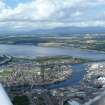
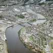
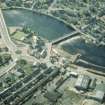
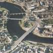
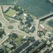
Inverness, Ness Viaduct


Railway Viaduct (19th Century) - (20th Century)
Site Name Inverness, Ness Viaduct
Classification Railway Viaduct (19th Century) - (20th Century)
Alternative Name(s) River Ness; Inverness Harbour
Canmore ID 13347
Site Number NH64NE 130
NGR NH 66306 46008
Datum OSGB36 - NGR
Permalink http://canmore.org.uk/site/13347


- Council Highland
- Parish Inverness And Bona
- Former Region Highland
- Former District Inverness
- Former County Inverness-shire
NH64NE 130 66306 46008
Location formerly cited as NH 6626 4602 to NH 6641 4594.
For adjacent (to N) Inverness Harbour, see NH64NE 129.00.
For adjacent (to S) Waterloo Bridge, see NH64NE 131.
Viaduct [NAT]
OS 1:2500 map, 1971.
Engineer: Mr Mitchell 1861-62
Collapsed.
REFERENCE: NMRS Print Room
1 large newspaper cutting from the Illustrated London News May 16th, 1863.
Probably stored in the Print Room.
(Undated) information in NMRS.
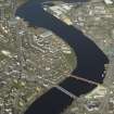
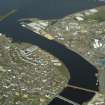
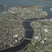
(Location cited as NH 663 460). Ness Viaduct: opened 1862 by the Inverness and Ross-shire Rly, engineer Joseph Mitchell. A handsome 11-span viaduct with five flat segmental arches, each 73 ft (22.2m) long, over the river. On the N side there is a single plate-girder approach span and on the S there are four short segmental arches and a plate-girder span.
J R Hume 1977.
Broken by floodwater February 1988; de-listed subsequently.
HBD List.
This viaduct was built by Joseph Mitchell and Deakin & Co (contractors) to carry the Inverness and Ross-shire Rly across the River Ness. The bridge was broken by floodwater on the night of 6/7 February 1989, its replacement (alongside) being opened on 9 May 1990.
The original structure was a stone viaduct of overall length 669 ft (203.9m) and maximum height 40 ft (12.2m) above the river bed.
M Smith 1994.
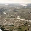
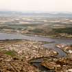
These successive viaducts carried and carry the Inverness - Wick, Thurso and Kyle and Lochalsh 'Far North' line of the former Highland Rly over the River Ness at the S limit of Inverness Harbour (NH64NE 129.00). The rebuilt viaduct remains in regular use by passenger traffic, and forms the S (upstream) limit of Inverness harbour (NH64NE 129.00).
The location assigned to this record defines the centre of the structure. The available map evidence indicates that it extends from NH c. 66265 46030 to NH c. 66379 45962.
Information from RCAHMS (RJCM), 29 March 2006.

