
The Ord


Field System (Period Unassigned), Hut Circle(S) (Prehistoric)
Site Name The Ord
Classification Field System (Period Unassigned), Hut Circle(S) (Prehistoric)
Canmore ID 4981
Site Number NC50NE 13
NGR NC 574 054
NGR Description Centred NC 574 054
Datum OSGB36 - NGR
Permalink http://canmore.org.uk/site/4981


- Council Highland
- Parish Lairg
- Former Region Highland
- Former District Sutherland
- Former County Sutherland
NC50NE 13 centred 574 054.
(NC 574 054) Settlement (NR) (eighteen features shown).
OS 1:10,000 map, (1970)
RCAHMS mention at least eighteen hut circles and enclosures numerous mounds and walls.
RCAHMS 1911.
A total of seventeen hut circles and enclosures were located.
Visited by OS (W D J) 19 June 1963.
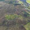
A scattered settlement of twenty-two hut circles, thirteen of which are oval, accompanied by a system of plots covering 43.3 hectares on the ridge of The Ord. The plots are formed by low lynchets and banks, on which generally large clearance cairns are piled.
R W Feachem 1973.
On the gently undulating north, east and south-east slopes of The Ord in open moorland, is a settlement of eighteen huts (A-T) within an associated field system. In the main the huts are poorly preserved, frequently denuded, and overgrown with peat, heather or bracken. They fall into two broad categories; there are eleven huts of simple form, varying from 5.5m to 10.0m internal diameter within a tumbled wall of earth and stone up to 0.5m high, and spread to 2.0m to 2.5m broad all round. In hut 'G' where inner and outer facing stones on edge are discernible, the precise wall thickness is 1.4m and this would appear to be the average for this type of hut. They are circular except 'G', which is oval, 8.5m by 7.4m internally. This example has an entrance in the NW where the position of a single portal stone suggests a splay; the other huts have their entrance in the SE arc,visible as a lowering in the wall. The position of the entrance to huts 'E' and 'L' is uncertain; in the former,stone clearance heaps overlie the east and west arcs.
The second category of hut includes D, J, N, R, S and T, and probably B. Four are oval oriented NW-SE, the others circular; all are of more massive construction with a thicker wall which appears to contain a greater ratio of stone to earth.
The internal dimensions vary from 9.0m diameter to 14.5m by 12.0m, the tumbled wall surviving to 0.8m mean height, and spread to 3.0m broad. (The actual wall width of hut 'J' is about 1.8m and this is probably the average). In at least four of the huts there is a distinct widening of the wall to about 4.5m spread at the entrance which in each case is in the SE arc on the longer axis. These entrances may be clubbed or splayed but vegetation obscures details. Hut 'N' within an 18th/19th century enclosure associated with run-rig is mutilated and overlaid in the SE arc by the ruinous enclosure wall.
The field system is best-preserved in the extreme south, and for about 10 hectares in the north, where well-defined lynchets and tumbled boulder walls incorporating clearance heaps delineate small irregularly shaped cultivation plots, average size 30.0m by 20.0m. The area between the hill summit and the bell cairn to the S (NC50NE 38) is occupied by post-medieval enclosures and run-rig with associated clearance heaps which has destroyed the original pattern of cultivation. The one example (hut 'E') of clearance overlying the wall indicates that not all huts and cultivation plots are contemporary.
(Of the eighteen features shown on OS 1:10,000, three are disproved as they are fortuitous arrangements of clearance and lynchets, and three (N, P and T) are new discoveries).
Surveyed at 1:10,000.
Visited by OS (N K B) 28 July 1976.
A further hut circle, 'U', visible as a low platform, was located at NC 5784 0517. The ill-defined hut measures 10.5m SE-NW by 8.0m within a low wall spread to 1.5m. The entrance in the SE has a large set stone on its S side.
All surveyed at 1/2500.
Visited by OS (J B) 15 March 1979.
Excavation and survey in March 1977 in advance of the erection of a new BBC transmitter near the summit of The Ord at NC 5737 0561, revealed a number of what appeared to be plough marks more likely to be of post-medieval rather than prehistoric date; and a ruined wall running from the adjacent chambered cairn (NC50NE 16). Four shallow gulleys found under the plough marks may only have been an earlier phase of rig cultivation. A single unworked flint flake was found on the surface of Layer 3. Part of the extensive field system between the summit and the road was examined. It comprised many small clearance cairns, terraces, and ruined dykes. Near the top of the survey area were the remains of 2 small hut circles with internal diameters of 5.2 and 8m.
Information from M J Yates, 1977 (see archive MS/180).
NC 580 051 'V': A well preserved oval hut circle with a turf covered rubble wall up to 3.0m wide and 1.1m high, enclosing an area of 10.2m EW by 11.8m NS, with a slightly 'clubbed' entrance on the S.
'W': 20m to SE of 'V' are the denuded remains of a small oval hut circle measuring overall 10.5m NW-SE by 8.5m transversely with an indistinct wall up to 2.3m wide. The entrance probably lay on the SE.
'X': 20m to S of 'W', another denuded small hut circle measuring internally 5.8m EW by 7.0m NS within denuded walling up to 1.8m wide. A later clearance cairn overlies the inner edge of the wall on the N.
NC 576 056 'Y': Situated on a terrace, a small hut circle lies within a larger hut circle. The former measures internally 6.0m EW by 7.3m NS within a rubble wall 1.3m wide. The entrance lies on the S. The larger hut circle measures 15.0m in diameter over a denuded spread rubble wall up to 3.0m wide. Its entrance has been utilised by the smaller hut circle.
D W Ross 1987.
Scheduled with NC50NE 13-14, 16, 17, 19, 22, 38-9, 46, 54-6 and 81-2 as The Ord, chambered cairns, cairns, settlements and field systems.
Information from Historic Scotland, scheduling document dated 14 February 2002.
Excavation (March 1977)
Excavation and survey in March 1977 in advance of the erection of a new BBC transmitter near the summit of The Ord at NC 5737 0561, revealed a number of what appeared to be plough marks more likely to be of post-medieval rather than prehistoric date; and a ruined wall running from the adjacent chambered cairn (NC50NE 16). Four shallow gulleys found under the plough marks may only have been an earlier phase of rig cultivation. A single unworked flint flake was found on the surface of Layer 3. Part of the extensive field system between the summit and the road was examined. It comprised many small clearance cairns, terraces, and ruined dykes. Near the top of the survey area were the remains of 2 small hut circles with internal diameters of 5.2 and 8m.
Information from M J Yates, 1977 (see archive MS/180).
Publication Account (1995)
The Ord is a low hill at the south end of Loch Shin. Prehistoric settlers here had ready access to both cultivable and grazing land, and salmon in the river for nine months of the year. There are remains of occupation from many different periods here: two neolithic chambered cairns, several bronze-age burial cairns, a large number of bronze-age or ironage hut circles, and post-medieval enclosures and ploughed fields.
The trail joins a track which leads uphill towards the television mast where a large cairn of bare stones stands near the top of the hill. This chambered cairn was excavated in 1967, and the chamber, antechamber and passage have been refilled, but some of the passage and its lintels are visible. The cairn is about 27m in diameter with a shallow forecourt. Cremation burials, sherds of pottery and flint flakes were found in the chamber, while bones from earlier burials may have decayed. When the tomb was blocked a stone platform with a boulder kerb, now grassgrown, was built round it. Above the collapsed corbels of the chamber a later cremation burial was found. On the highest part of the hill are the remains of another chambered cairn, of which only the large slabs in the chamber and passage remain, with mere vestiges of cairn material.
Scattered across the hill are a number of hut circles. Some 23 or so have been recorded, and it should be possible to locate at least 15 with the aid of the sketch plan given here. They may be of various dates and built and rebuilt over many centuries. There are also a large number of clearance cairns of unknown date dotted around this area, and a few traces of what may be prehistoric field walls. The cairns are particularly noticeable each side of the track before the path diverges from it. The hut circles are overgrown, but most make a noticeable circle in the heather. Occasionally the facing stones in the wall, or the entrance gap, usually on the southern side, can be seen. Just south of the chambered cairn on the very top of the hill is a bronze-age round ca irn with much of its kerb traceable. Immediately east of this is a hut circle in grass and so easier to see.
Other features on The Ord include the overgrown stone walls of more recent enclosures, within which and also outwith which the ridge and furrow of plough cultivation has been seen on air photographs and can be seen on the ground when the sun is low. Towards the south end of the area, with an enclosure wall crossing it and a recent fence intruding on its ditch is an enigmatic structure marked by two circles on the plan. This has been considered to be an unusual form of ditched ring cairn, but it consists of something very like a hut circle within a ditch and an outer bank, and it could be a fortified hut. There are a few similar sites in the Highlands, but none has yet been excavated.
There are more hut circles and clearance cairns between Lairg and Invershin on the slopes east of the A 836 as shown on the OS map; excavation has shown that these hut circles range in date from the 2nd millennium to the mid-1st millennium BC.
An audio-visual programme in the Ferrycroft Countryside Centre shows human impact on the landscape and archaeological sites.
Information from ‘Exploring Scotland’s Heritage: The Highlands’, (1995).
Ground Survey (22 February 2010 - 18 March 2010)
NC 575 050 A topographic survey of the scheduled area and a 100m buffer zone around the The Ord was carried out 22 February–18 March 2010. The area contains a high density of archaeological monuments, including Neolithic funerary monuments and remains of Bronze Age settlements and agriculture. Although the distribution of the major features was known, this survey added detail and increased the accuracy of information obtained in previous surveys. The survey also identified several previously unrecorded features. In total over 450 individual archaeological features were recorded including a burnt mound, c35 hut circles, 14 rectangular buildings and over 300 clearance cairns.
Archive: RCAHMS
Funder: The Forestry Commission Scotland

