
Sanday, Scar Steading, Scar House


Farmstead (19th Century)
Site Name Sanday, Scar Steading, Scar House
Classification Farmstead (19th Century)
Alternative Name(s) Westove
Canmore ID 3487
Site Number HY64NE 13
NGR HY 67072 45115
Datum OSGB36 - NGR
Permalink http://canmore.org.uk/site/3487


- Council Orkney Islands
- Parish Cross And Burness
- Former Region Orkney Islands Area
- Former District Orkney
- Former County Orkney
HY64NE 13.00 67072 45115
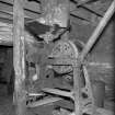
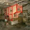
HY64NE 13.01 67020 45154 Threshing mill.
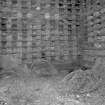
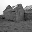
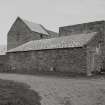
HY64NE 13.02 67009 45143 Dovecot and adjoining drying kiln.
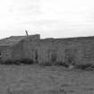
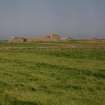
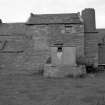
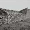
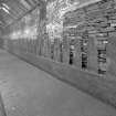
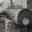
(Location cited as HY 670 452). Scar Mills, 18th to 19th century. The watermill, part of the steading, is a rectangular two-storey rubble building with revolving kiln vent. Nearby is the stump of a windmill (HY64SE 46). This has a solid rubble base, with a short hollow extension. Access is by an opening above the base.
J R Hume 1977.
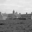
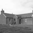
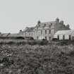
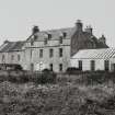
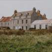
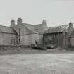
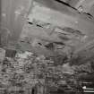
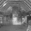
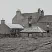
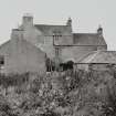
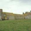
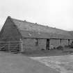
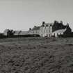
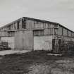
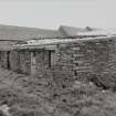
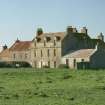
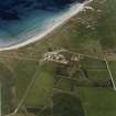
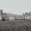
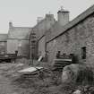
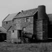
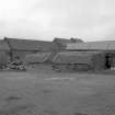
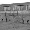
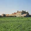
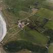
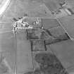
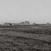
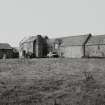
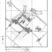
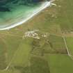
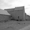
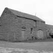
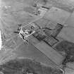
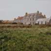
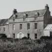
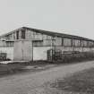
[Scar steading].This very extensive complex is U-plan in shape and incorporates a large dwelling. The dwelling range also includes a steam-powered threshing and grain mill with a substantial kiln (HY64SE 13.01). The complex also includes an appended dovecot and implement shed, another range containing a carriage house and stable and a detached worker's house, with closet and garden. This is one of the few Sanday steadings that had a cart shed (converted to stabling) and had a very early silage shed built between 1879 and 1901. There is also a new cattle shed with midden. The steading is in agricultural use as a feed store, cattle shed and for clipping and lambing. The buildings are in a fair condition but the house was unoccupied and in poor condition on the date of visit.
(See NMRS MS 500/36/94 for layout and survey details).
Visited by RCAHMS (GJD) August 1996.
RCAHMS and NMS, 1998.
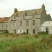
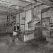
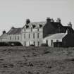
Extensive farm complex comprising 2-storey and dormered attic, 4-bay L-plan house, (later, single storey former schoolroom adjoined to SE) with lower, 2- and single-storey, crowstepped-gabled adjoining range projecting to NW, with terminating threshing mill, accompanying boiler house and chimney; lectern doocot disposed at right angles; further byre/store/cartshed ranges, forming farm courtyard with yard entrance to NE range; parallel ranges of single storey byres/sheds to centre of courtyard; large walled garden to NE of main house, (NW wall forming SE range of farm yard); single storey, complex-plan farm cottage to SE of main house, early 19th century core with later extensions.
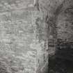
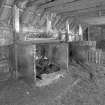
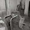
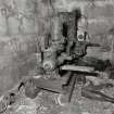
A large, self contained farm complex, important for its size and range of facilities. The long SW range includes a threshing mill and boiler house as well as a doocot, which provided an important source of winter meat. The 2-storey block which immediately adjoins the house was possibly a former smithy, the basement containing a very large furnace with hand-operated bellows, still in working order. The late 19th/early 20th century saw a schoolroom added to the south end of the house with a good boarded interior. The farm had been established by the 17th century and took over an entire township (Marwick); it was the seat of the Traills of Westove. The factor, James Scarth, occupied the house before it passed to George Horwood in the later 19th century. (Historic Scotland)

