
Pricing Change
New pricing for orders of material from this site will come into place shortly. Charges for supply of digital images, digitisation on demand, prints and licensing will be altered.
Iona, Iona Abbey


Abbey (Medieval), Cathedral (Medieval)
Site Name Iona, Iona Abbey
Classification Abbey (Medieval), Cathedral (Medieval)
Alternative Name(s) Iona, St Mary's Cathedral; St Mary's Abbey
Canmore ID 21664
Site Number NM22SE 5
NGR NM 28683 24515
Datum OSGB36 - NGR
Permalink http://canmore.org.uk/site/21664


First 100 images shown. See the Collections panel (below) for a link to all digital images.
- Council Argyll And Bute
- Parish Kilfinichen And Kilvickeon
- Former Region Strathclyde
- Former District Argyll And Bute
- Former County Argyll
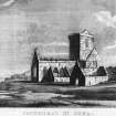
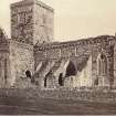
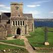
Founded shortly before 1203 on the site of the Columban abbey, the Benedictine Abbey on Iona comprised a church dedicated to St Mary and a monastery dedicated to St Columba. In 1499 the church became the Cathedral of the Bishops of the Isles. Reportedly damaged by a reforming mob in 1561, by the end of the 17th century the abbey had fallen into ruins. Restoration work began at the end of the 19th century and, in 1938, the newly formed Iona Community took over the running of the abbey.
Information from RCAHMS (SC) 2 August 2007
NM22SE 5 28683 24515
NM22SE 5.01 NM 2871 2453 Abbey Museum Museum
NM22SE 5.02 NM 2870 2451 'Michael Chapel' Chapel
NM22SE 5.03 NM 2867 2451 Crosses, cross-slabs
NM22SE 5.04 NM 28678 24544 Abbot's House
For coin hoard found in Iona Abbey (NM 2865 2451), see NM22SE 2. For Iona, Early Christian Monastery (NM 286 244) and related crosses, see NM22SE 4.00. For Iona Nunnery (NM 2843 2410), see NM22SE 14.
(NM 286 245) St Mary's Cathedral (NR) (In Ruins)
OS 6" map (1900)
A modern restoration of the Benedictine Abbey whose church became the Cathedral of the Bishops of the Isles in 1499.
The Abbey was founded before 9th December 1203 when a papal letter confirmed its possessions to the abbot and convent. The monastery was dedicated to St Columba - as witness a papal letter of 1247 addressed to "the abbot of the monastery of St Columba of the order of Saint Benedict" - and the church to St Mary. It is said to have been damaged by a reforming mob in 1561 and by the end of the 17th century, the buildings were in ruins. Since the end of the 19th century, the whole complex has been restored, first by the Duke of Argyll and since 1938 by the Iona Community.
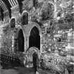
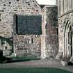
The abbey is unusual but not unique in having its monastic buildings to the north of the church, presumably because of the water supply, and in having three detached buildings. Those on the east - now the Michael Chapel (NM 2870 2451) and the Museum (NM 2871 2453) - may have been a chapel and the infirmary while that on the west (NM 2564 2452) was the Old Guest House.
The church shows evidence of alterations and additions but since all are made with the same type of red granite they are difficult to date. A suggested building history could be a Romanesque church built about 1190, an eastern building or additon in the 13th century, a rebuilding or enlarging about 1420 and a final refurbishing about 1500. An added complication is the fact that the lines of a cruciform church, smaller and earlier than the Abbey, underlie it and may date from the late 12th century.
The square precinct wall of the Benedictine monastery has been defined by excavation. It ran between the monastery and Tor Abb and a gateway was exposed with Sraid nam Marbh running through. Thomas says it was essentially that which stood until about 1860.
D E Easson 1957; W F Skene 1875; D MacGibbon and T Ross 1897; D M Wilson and D G Hurst 1968; A C Thomas 1959; R Reece, undated
As described. No definite trace of the precinct wall could be found although a wall running S from the "Guest House" may represent the remains.
Visited by OS (RD) 9 June 1972
Limited excavation took place while a hole to house the underground plantroom for a new heating system was machine dug to the E of the Abbey. Layers and features, including a stone-linked drain, were noted and sampled. Finds of pottery, iron and animal bone were made.
A Haggarty 1983
NM 286 245 An assessment was undertaken at Iona Abbey in September 2002 in order to advise on potential damage to archaeological features in advance of disabled access being constructed. Three trenches were excavated: two within the main entrance passageway, and the third to the E inside the abbey. The trenches were excavated down to archaeologically significant features but did not remove them, thereby giving an indication of the depth of material that could be safely removed during the construction.
Archive to be deposited in the NMRS.
Sponsor: HS
G Ewart and A Radley 2002
Archaeological monitoring was undertaken in July 2004 during the partial demolition and reconstruction of a disabled access ramp into the cloisters. The ramp consisted primarily of the existing underlying rubble used to construct the former stepped access, running E-W from the main entrance and terminating at the cloisters. No finds of archaeological significance were made.
Archive to be deposited in the NMRS.
Sponsor: Historic Scotland
C Shaw 2004
See also NM22SE 5 01 and for replica NM22SE 4 05.
Iona, Iona Abbey.
IG Lindsay Collection, 29 - early drawings.
IG Lindsay Collection, W/1.
Iona, Iona Abbey.
Information from Brian Edwards, Old Schoolhouse, Causewayend. Kirknewton, 17/2/1986.
I notice that in your report on Iona, you atrribute a set of plans to Peter MacGregor Chalmers which should really I think be attributed to John Honeyman. The plans in question AGD/23/630-635 all bear the address of Honeyman ie: 140 Bath St, Glasgow. The plans are mentioned in 2 letters from John Honeyman to Thackeray Turner at SPAB. In the first (30 June 1891) Honeyman says:
'I have been asked (by the Duke of Argyll) to report on the practicability of roofing in part of the building and have reported that it is quite practicable to roof the choir, the central tower and the south transept without interfering with any of the old work and I strongly recommend that this should be done in order to preserve thenvery interesting old work..'
But three months later Honeyman reports to Turner again (10 Oct 1891):
'I regret very much to say that the idea of doing something of the same kind (as at Dunblane) at Iona has been abandoned. I feel that you may regard this rather as a matter of congratulation but in that I think you are entirely mistaken. The style of the drawings (especially AGD/23/634) suggests that if anybody helped Honeyman it may well have Sandy MacGibbon whose article on Iona appeared in 'The Builder' in 1893 (pp336-40). I know Chalmers prepared plans much later (1908) but I think three 1891 plans were produced by Honeyman or at least under his direct guidance.
John Honeyman was the Glasgow correspondent of SPAB from 1878-1891 and almost the society's sole Scottish member. His observations on Scottish cathedrals undergoing restoration are of much interest and figure largely in my PhD thesis presently in preparation.
Iona, Iona Abbey.
Ross sketch books MS 28/463/13/1-6 - architectural detail
8/29 sedilla
Antiquarian Observation (1874 - 1877)
Modification (1891)
Modification (1 January 1908 - 31 December 1914)
Field Visit (1 August 1922 - 31 August 1922)
Modification (1 January 1931 - 31 December 1932)
Modification (1931)
Photographic Record (18 April 1934 - 7 July 1938)
Photographs taken by the architect Ian G Lindsay on visits to the Abbey. Includes photographs taken during restoration of the Abbey.
Modification (1 January 1939 - 31 December 1941)
Modification (1 January 1952 - 31 December 1965)
Photographic Survey (1 May 1965 - 31 May 1965)
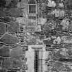
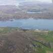
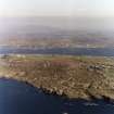
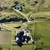
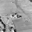
Aerial Photography (April 1969)
Oblique aerial photographs of sites and monuments on Iona, Argyll, photographed by John Dewar in 1969.
Measured Survey (1970)
Field Visit (9 June 1972)
As described. No definite trace of the precinct wall could be found although a wall running S from the "Guest House" may represent the remains.
Photographic Survey (1 January 1973 - 31 December 1974)
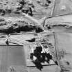
Trial Trench (1974)
In co-operation with the RCAHMS, a series of trenches were excavated around the abbey church to test certain points and difficulties of the interpretation of the restored Benedictine buildings.
Richard Reece 1981, 55
Photographic Survey (1976)
Excavation (1977)
Photographic Survey (1978)
Excavation (1 January 1980 - 31 December 1981)
Field Visit (June 1980)
Iona Abbey
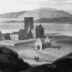
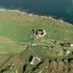
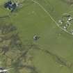
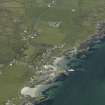
The restored buildings of the former Benedictine abbey are situated some 250m from the w shore of the Sound of Iona, at an elevation of about 19m OD. The abbey stands near the centre of the area occupied by its Celtic predecessor, as defined by the earthworks of the vallum, and the crosses named after St John, St Martin and St Matthew are prominent features of the area immediately W of the abbey church. The medieval foundation enjoyed continuity not only of site but also of name with the Celtic community, for the current description , 'St Mary's Abbey' , is a misnomer based on the reports of early travellers, who recorded the local tradition that the church was dedicated to the Virgin Mary. Medieval sources relating to the abbey consistently describe it as the 'monastery of St Columba', and the same designation appeared on the conventual seal, which depicted the saint himself. Although some of these references may represent latinisations of the place-name I Chaluim Chille, others are explicit in their application to the monastic house; it appears that the dedication of the church was distinct from that of the abbey as a community.
The immediate area of the Abbey is bounded on the w by the rocky outcrop of Torr an Aba, whose summit was occupied in the medieval period by a free-standing cross, and on the N by Sruth a' Mhuilinn, the mill-stream, from which water was evidently channelled to flush the reredorter. Although Reilig Odhráin was the principal cemetery for laymen during the medieval period, the area s and w of the nave of the abbey church was also used for burial, perhaps serving as the monastic cemetery. This use is represented by a small group of early graveslabs located about 8m S of St Martin's Cross and several interments have been discovered during excavation in the areas indicated. Until the late 18thcentury the abbey was linked to Reilig Odhráin by a medieval paved street, which was re-exposed by excavation in 1962. Similar streets from the Nunnery and from the landing-places at Port nam Mairtir and St Ronan's Bay converged at MacLean's Cross and continued past St Mary's Chapel towards the choir of the abbey church.
The existing boundaries of the abbey enclosure were established in the 1750s, when steps were taken by the 3rd Duke of Argyll to protect the ruins. The only description of an earlier stone-built wall is given by Sacheverell who, writing in 1688, included Reilig Odhráin within the enclosed precinct. It is known from excavation, however, that both in the medieval period and in the 18th century the area immediately N of Reilig Odhráin and E of the medieval street was cultivated. No trace of a medieval boundary can now be identified, with the doubtful exception of a wall running S for about 95 m from the abbey coffee-house, on the W side of the road below Cnoc nan Carnan. This wall is of unusually massive construction, having a thickness of about 1·4m and incorporating large facing-stones. In the medieval, as in the Early Christian period, elaborate provision was made for the drainage of surface water. A stone-lined drain running ESE was constructed in the partially-silted early ditch at the N boundary of Reilig Odhráin, and a similar drain associated with a boulder-filled soakaway pit at the E edge of the medieval street was built some 30m further N. Numerous stone-lined drains have also been recorded under and near the abbey buildings. They include one, whose course is still partly visible, running from the w mid-buttress of the s wall of the nave towards the SW angle of the S transept; a series of W-E drains discovered in the W part of the cloister garth; a drain which runs from the N door of the refectory undercroft to its SW door; another which was exposed N of the E buttress of the N wall of the refectory and runs SSE below that building, probably continuing as a N-S drain below the E walk of the cloister and thence diagonally below the slype; and a drain underlying the wend of the 'Michael Chapel' , which was traced from a point 5 m N of the N door of the chapel to another point 5 m S of its S wall.
See RCAHMS 1982 pp.49-152 for a full architectural and historical description.
RCAHMS 1982, visited September 1980
Photographic Survey (1980)
Field Visit (1981)
Excavation (1983)
Limited excavation took place while a hole to house the underground plantroom for a new heating system was machine dug to the E of the Abbey. Layers and features, including a stone-linked drain, were noted and sampled. Finds of pottery, iron and animal bone were made.
Project (1995)
NM 286 245 (Abbey); NM22SE 14 (Nunnery) Resistivity and geophysical surveys were undertaken at Iona Abbey and Nunnery (see NM22SE 14) by Geophysical Surveys of Bradford for AOC (Scotland) Ltd.
At the Abbey, several magnetic and high resistance anomalies correspond to known features (walls, paths or service structures). Other high resistance anomalies S and E of the Abbey complex, form clear linear traces and may correspond to buried drains. A group of weakly-defined, linear, high resistance anomalies forms a rectilinear pattern within the NW angle of the present boundary wall. The appearance of these features is of buried walls, but they may simply be drains or garden features.
There is no obvious continuity between features identified in the environs of the Abbey by these surveys and features to the S of this area which were identified by an earlier resistivity survey conducted by the Royal Commission (RCAHMS 1981).
Sponsor: Iona Cathedral Trust Ltd.
J O'Sullivan 1995
Magnetometry (1995)
NM 286 245 (Abbey); NM22SE 14 (Nunnery) Magnetometry survey.
J O'Sullivan 1995
Earth Resistance Survey (1995)
NM 286 245 (Abbey); NM22SE 14 (Nunnery) Resisitivity survey.
J O'Sullivan 1995
Watching Brief (20 June 2001 - 21 June 2001)
Kirkdale Archaeology were asked, under the terms of the P.I.C. call-off contract, to monitor the excavation of a cable trench near Iona Abbey. The trench, to be dug by hand by the Historic Scotland squad, lay to the W of the Abbey, following the line of the road, and ran from an existing substation to the Abbey ticket hut.
The work involved such limited disturbance, in an area probably already disturbed by the road construction, that nothing of archaeological significance was noted.
Sponsor: Historic Scotland
Kirkdale Archaeology
Excavation (1 September 2002 - 30 September 2002)
NM 286 245 An assessment was undertaken at Iona Abbey in September 2002 in order to advise on potential damage to archaeological features in advance of disabled access being constructed. Three trenches were excavated: two within the main entrance passageway, and the third to the E inside the abbey. The trenches were excavated down to archaeologically significant features but did not remove them, thereby giving an indication of the depth of material that could be safely removed during the construction.
Archive to be deposited in the NMRS.
Excavation (24 February 2004 - 27 February 2004)
NM 286 245 Archaeological monitoring was undertaken in February and July 2004 during the partial demolition and reconstruction of a disabled access ramp into the cloisters. The ramp consisted primarily of the existing underlying rubble used to construct the former stepped access, running E–W from the main entrance and terminating at the cloisters. No finds of archaeological significance were made.
C Shaw 2004
Sponsor: Historic Scotland
Kirkdale Archaeology
Watching Brief (8 November 2010)
NM 286 245 (centred on) A watching brief was maintained on 8 November 2010 during the excavation of seven small holes for permanent survey markers. None of the holes were deep enough to disturb significant archaeological deposits.
Archive: RCAHMS (intended)
Funder: Historic Scotland
Kirkdale Archaeology 2010
Information also reported in Oasis (kirkdale1-171118)
Field Visit (October 2010 - January 2011)
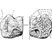
NM 28683 24515 This large and impressive collection of carved stones is stored in various locations, with the stones assessed during October 2010–January 2011, kept at the St Columba Centre, Fionphort and in the chapel of St Ronan’s on Iona. A substantial group of stones come from the Nunnery cloisters, so their storage location in St Ronan’s is appropriate. The stones consist of a number of voussoirs, one with low-relief carved decoration. In addition, there are two very highly decorated rectangular blocks, now at Fionphort. Since nothing remains of the nunnery cloisters, the stones are the only evidence of their original appearance. Three of the stones have been described and illustrated in RCAHMS Argyll, vol 4, Iona. Another group of voussoirs, although very eroded, have rows of dog-tooth ornament, and this arrangement can be found in the N choir arcade of the abbey church, where several voussoirs have been replaced.
This and other inventories of carved stones at Historic Scotland’s properties in care are held by Historic Scotland’s Collections Unit. For further information please contact hs.collections@scotland.gsi.gov.uk
Funder: Historic Scotland
Archetype, 2011
Project (2010)
NM 2868 2451 A geophysical survey was commissioned by the NTS as part of a management project on Iona. The work aimed to use non-invasive techniques to aid in the identification of any sub-surface archaeological features in three fields to the N, E and S of Iona Abbey. In particular it intended to provide more information about the system of field drains in the area, including a broken field drain to the S of the abbey, which had caused severe water-logging.
Gradiometer and resistance surveys were undertaken over c3ha with selective transects also covered using GPR. The gradiometer and resistance surveys produced good results, although the presence of igneous intrusions and magnetic sands and gravels across the site complicated the interpretation of data from the gradiometer survey. The resistance survey produced a more coherent series of results. Both the gradiometer and resistance surveys detected the vallum bank and ditch running to the N and E of the Abbey complex. A further probable ditched feature was visible in both surveys, running to the S of and along a similar alignment
to the vallum. The resistance survey identified an apparent return at the eastern end of this feature, where it turns to run SSW–NNE. This feature coincides with an earthwork recorded by RCAHMS.
The resistance survey also detected a possible enclosure associated with the Bishop’s House. A series of ditches and enclosures were visible in the resistance data from the southernmost field surveyed. For example, a possible rectangular ditched enclosure was recorded immediately SW of St Mary’s Chapel. Some of these features, particularly those along the W edge of the field, correlated with anomalies identified during the gradiometer survey.
Archive: ORCA Geophysics
Funder: The National Trust for Scotland
Amanda Brend – ORCA Geophysics
Earth Resistance Survey (2010)
NM 2868 2451 Resistance survey.
Archive: ORCA Geophysics
Funder: The National Trust for Scotland
Amanda Brend – ORCA Geophysics
Magnetometry (2010)
NM 2868 2451 Magnetometry survey.
Archive: ORCA Geophysics
Funder: The National Trust for Scotland
Amanda Brend – ORCA Geophysics
External Reference (28 October 2011)
Scheduled as element within 'The monument known as St Mary's Abbey, Iona, monastic settlement [comprising] the remains of the large early historic monastic settlement founded by St Columba in AD 563, St Martin's Cross, and parts of medieval buildings associated with the Benedictine Abbey of St Mary founded around AD 1200.'
Information from Historic Scotland, scheduling document dated 28 October 2011.
Standing Building Recording (October 2012)
NM 28683 24515 (NM22SE 5.00) The final two phases of the assessment of the abbey’s carved stone collection were completed by October 2012. The stones in phase 3 are stored in the roof space and consist mainly of stones from the abbey’s cloisters – column bases, shafts and capitals, as well as voussoirs. Although these stones are extremely weathered, traces of the original decorative carving can still be seen. It is also possible to see how the column bases and shafts were intended to be fitted together, with mortice and tenon joints visible on column bases and shafts.
The stones included in phase 4 of the collection had been removed from Iona many years earlier, and were stacked outside the Columba Centre in Fionnphort. The stones in this latter group were left over from the 1960–70s’ restoration and replacement work in the cloisters. So the stones in phase 3 would have been removed to allow their replacement with these modern versions in phase 4. Again, some of the stones were column bases, shafts and capitals, but the largest group were voussoirs. There is a deliberate differentiation in these modern versions, whereby the dog-tooth ornament is simplified to create a smoother surface profile.
Another group of stones was left over from restoration work on the night stair, forming a set of coping stones. Some of these had still legible names incised in the ends, eg Black, Thompson, Weatherup, Summers and Collins. Finally, there was one intriguing piece which appears to have been a practice stone for a cloisters capital. This has a very clear low-relief carving of a thistle on a chamfered edge, and is a simplified version of a capital now in the cloisters, which shows a similar thistle on a paired capital.
This and other inventories of carved stones at Historic Scotland’s properties in care are held by Historic Scotland’s Collections Unit. For further information please contact hs.collections@scotland.gsi.gov.uk
Mary Márkus, Archetype
2012
Excavation (29 October 2012 - 1 November 2012)
Under the terms of its PIC Call-Off contract with Historic Scotland, Kirkdale Archaeology was asked to excavate two small trenches near the entrance to Iona Abbey, in the SW corner of the site grounds. These trenches were intended to locate and re-excavate the site of three older trenches. This work was undertaken to attempt to assess the suitability of this area for the construction of a new ticket office from an archaeological and an engineering point of view.
G Ewart 2012
Sponsor: Historic Scotland
Kirkdale Archaeology
Ground Penetrating Radar (18 September 2012 - 21 September 2012)
NM 2859 2453 (centred on) A series of geophysical surveys was undertaken 18–21 September 2012 at Iona Abbey in advance of the construction of a proposed new ticket booth. The surrounding area of lawn N of the Torr an Aba was also surveyed to provide information about the immediate environs.
The survey covered a 0.32ha area of lawn W of Iona Abbey, between the public road, Torr an Aba and the Road of the Dead. The SW area is level, but rises at a gradual incline toward the NE half way across. The lawn is flanked by the steep sides of the Torr an Aba to the E, a boundary wall to the W and N, and cemetery wall to the S.
This series of geophysical surveys has produced good quality data, and important potentially early medieval findings include the possible continuation of a vallum ditch across the S area of the survey. Other possible monastic settlement remains were confined to the S half of the survey, in particular the area N of the possible ditch and the old road. Notable among these was a possible enclosure and building located by the radar at depth. This has the potential to be very significant in situ Early Christian monastic remains, which are worthy of further investigation. Several probable excavation trenches associated with Thomas’s investigation in the 1950s and 60s were also located. A programme of excavation will be necessary to resolve the character, date and significance of the archaeological remains.
Archive: RCAHMS (intended)
Funder: Kirkdale Archaeology on behalf of Historic Scotland
Oliver JT O’Grady, OJT Heritage 2012
OASIS Id: kirkdale1-310899
Excavation (20 February 2013 - 11 April 2024)
Under the terms of its PIC call-off contract with Historic Scotland, kirkdale Archaeology was asked to provide archaeological monitoring of works associated with the construction of a new ticket office at Iona Abbey, as well as excavate a small trench to facilitate the construction of a signboard near the W front of the Abbey, just S of Columba’s Shrine.
Information from OASIS id: kirkdale1-311432 (D Murray) 2013
Excavation (22 January 2013)
Under the terms of its PIC call-off contract with Historic Scotland, Kirkdale Archaeology was asked to examine a small area over ‘The Street of the Dead’ to the SW of Iona Abbey, Iona (Fig.1) in order to assess its makeup and condition in detail.
The present evaluation produced no relevant dating evidence for the Street of the Dead; the evidence
from the 1970s excavation suggests a broad medieval date. It is of course entirely possible that this is a significantly older route that was resurfaced in the middle ages, presumably as part of the Benedictine
phase of occupation.
The significant build-up of soil over this road, at least on its W side is interesting. Work by Kirkdale to the W of the Street of the Dead (still on-going) suggests a deep plough soil in this area. This is presumably what overlies the road surface, and it is interesting that the stones of the road were evidently buried deeply enough to survive.
Information from OASIS Id: kirkdale1-311432 (D Murray) 2013
Excavation (15 May 2013)
NM 2856 2448 Access gate construction: Two small post settings, each 0.4 x 0.4m, were dug at the SW entrance to the site. A crude cobbled surface was recorded at a depth of 160mm.
Source: Historic Scoltand
D Murray 2013
Kirkdale Archaeology
OASIS Id: kirkdale1-311432
Excavation (20 November 2013)
Under the terms of its PIC call-off contract with Historic Scotland, Kirkdale Archaeology was asked to undertake a small scale excavation at Iona Abbey, on Iona, in order to evaluate the area immediately around the threshold to the shop ahead of the proposed reworking of the entrance in order to provide enhanced disabled access into the premises.
The excavation revealed extensive disturbance associated with the insertion of relatively recent drainage and services, along with associated episodes of levelling. Context 004 in particular appears to be associated with the levelling for the construction of the modern concrete step. Nothing of archaeological significance was revealed during the course of the work.
Excavation (18 March 2015 - 20 March 2015)
Under the terms of its PIC call-off contract with Historic Scotland, Kirkdale Archaeology was asked to undertake a small scale excavation at Iona Abbey in order to monitor the excavation of a trench to determine the location of a leak from a pipe which had flooded an area of ground between the Michael Chapel and abbey museum to the north-east of the main cluster of abbey buildings.
The excavation revealed extensive disturbance associated with the insertion of relatively recent drainage and services, along with associated episodes of levelling. Context 004 in particular appears to be associated with the levelling for the construction of the modern concrete step. Nothing further of archaeological significance was revealed during the course of the work.
G Ewart 2015
Sponsor: Historic Scotland
Kirkdale Archaeology
Ground Penetrating Radar (5 November 2016 - 6 November 2016)
NM 28683 24515 (NM22SE 5) A ground penetrating radar (GPR) survey was undertaken, 5–6 November 2016, over several areas within and around Iona Abbey. The survey, which forms part of wider research project (see below), aimed to assist this research by placing features revealed during past excavations in a wider context. A total area of c0.43ha was investigated.
The GPR survey has detected a wealth of anomalies, although the data is not particularly coherent in some areas. This is not unexpected given the degree of change and development over the lifetime of the site. The clearest anomalies are due to former paths and presumed access roads and drainage features across the site.
Anomalies of potential interest have been identified within the cloister area which may indicate structural remains. Immediately to the W of the Abbey there are suggestions of well-defined areas of paving and possibly associated paths which may be significant. Additional anomalies which may indicate earlier structures have also been detected. Similar responses have been recorded to the N and E of St Michael’s Chapel.
The results to the S of the abbey are enigmatic. Previous excavations in the area identified a substantial stone feature, the GPR data did not clearly map its extent. Several anomalies have been detected which may be of interest, they are not particularly coherent, but the data does suggest
possible structural remains. This may be due to rubble and paving masking responses from deeper features. However, it is possible that the complexity of the data is indicative of a wealth of archaeologically significant buried deposits.
Archive: Rose Geophysical Consultants
Funder: Glasgow Iona Research Group on behalf of Historic Environment Scotland
Susan Ovenden - Rose Geophysical Consultants
(Source: DES, Volume 18)
Excavation (13 May 2017 - 3 June 2017)
NM 28683 24515 (NM22SE 5) Two trenches originally excavated in 1956/7 by a team led by Charles Thomas were re-excavated to obtain radiocarbon dates and environmental samples, 13 May – 3 June 2017.
Trench 1 (NM 28497 24553) was a long section through the monastic enclosure banks and ditch (Thomas’ Cutting 6). Detailed sections of the inner bank deposits showed a complex layering of turf bands and dumped ditch material, lying on a buried peaty soil. Micro-morphological soil samples and radiocarbon dates should establish whether the bank is multiphase in construction. The ditch was bottomed and revealed waterlogged deposits full of plant material and containing insect remains. This material has been sent to specialists for analysis. The ditch appears to show two episodes of infill. The outer bank was of different simpler
construction, bounded by a stone kerb and may be a later field boundary.
Trench 2 (NM 28662 24484) expanded on Thomas’ Cutting 11d, which had exposed an unusual dry stone wall. Excavation revealed that the wall was a revetted foundation for a structure with a curved end, possibly an apse of an early chapel, such as that at Dunfermline Abbey. The walling, which was battered, survived to a height of 1.0m, and was composed of local unfaced boulders up to 0.7m in length. The upper four courses had been rebuilt and added to in 1957 to leave a short section outlining the wall’s position at the surface. The wall was c0.8 m wide, at least 6m long, and the curved part appeared to have a well built inner face. A spread of similar large boulders encased in purplish clay lay to the E, suggesting the collapse or destruction of a clay-bonded superstructure. The structure appeared to have been demolished and robbed, and was sealed by spreads of building debris and mortar-mixing layers. This material contained medieval pottery including Scottish white gritty ware jugs, and was interpreted as debris from the construction of the 13th-century Benedictine Abbey. A series of deposits of sands, gravels and soil on the exterior of the walling included a thick layer of iron-working debris. These layers predated the demolition of the walling and were interpreted as levelling deposits, but are so far undated. The walling was built directly on a peaty buried soil and appeared to be the first feature constructed in this part of the monastic enclosure. Later features included a massive stone-pit associated with the renovation of the Abbey church around 1900, and a roadway associated with the Iona community renovations in the 1930s.
Trench 3 consisted of two small trial trenches in the field to the S of the abbey precinct. These were located to try to locate a broken field drain which was causing flooding and leading to puddling of the deposits by cattle. Trench 3a (NM 28656 24393), located a disused water pipe which
cut through surviving archaeological deposits consisting of a layer of burnt material. This layer contained several sherds of handmade pottery including craggan ware type, and iron slag. These deposits lay within a sub-rectangular enclosure measuring c30 x 50m, previously revealed by
geophysical survey undertaken for the National Trust for Scotland. Parallel furrows in the subsoil beneath these deposits appeared to be plough furrows predating the post-medieval period. Trench 3b (NM 28638 24395)
revealed a broken rubble drain which had been repaired with a plastic pipe, but the area was continually flooded and no further investigation took place. Documentary references refer to an old well in this area, Tobar Odhrain.
Geophysical survey of the NW corner of the monastic enclosure and around the chapel of Cladh an Disirt was also undertaken and is reported above. Archive: University of Glasgow then NRHE
Funder: Historic Environment Scotland
Website: https://www.gla.ac.uk/schools/humanities/research/
archaeologyresearch/groups/iona/
Ewan Campbell, Derek Alexander and Cathy MacIver – University of Glasgow
(Source: DES, Volume 18)
Earth Resistance Survey (23 February 2018)
NM 28683 24515 A resistance survey was carried out, 23 February 2018, to the S of the Abbey in the area of excavations undertaken in 2017. The survey aimed to refine interpretation of the 2016 GPR survey, and to place excavated features within a wider context.
Resistance survey was undertaken at 0.5m intervals using a 0.5m probe separation, and 1m probe separation with data collected at 1m by 0.5m intervals. The larger probe separation has a slightly greater depth of investigation, but there is a loss of lateral resolution in the 1m data set. A total area of 0.2ha was surveyed.
The resistance survey shows good correlation with the 2016 GPR survey, but the responses in the immediate area of the recent excavation are somewhat diffuse, which is to be expected. The resistance surveys suggest that a previously excavated wall extends farther to the N. There is no definitive western return of a potential structure, although all data sets have detected more ephemeral anomalies which may suggest a feature some 8m in length.
Further weak trends suggest a possible rectangular feature c20 x 6m in size, with possible internal divisions, and with previous excavations lying at the SE corner. However, interpretation is extremely cautious as the responses are ephemeral and in an area of modern ground disturbance, such as 1950s excavations, former paths/tracks and landscaping.
Archive: Rose Geophysical Consultants
Funder: CFA Archaeology on behalf of HES
Susan Ovenden - Rose Geophysical Consultants
(Source: DES, Volume 19)
Watching Brief (17 November 2021 - 24 November 2021)
A watching brief was carried out by CFA Archaeology Ltd for the Minor Archaeological Works Call-Off Contract, as part of the work to replace the heating system within the abbey church at Iona Abbey. Two sections of floor were lifted and shallow trenches excavated to allow the replacement of
under floor pipes. All work was carried out by hand and no remains of archaeological significance were encountered.
Information from CFA Archaeology Ltd.
Watching Brief (November 2021)
NM 28683 24515 A watching brief was carried out, in November 2021, as part of the work to replace the heating system within the abbey church at Iona Abbey. Two sections of floor were lifted and shallow trenches excavated to allow the replacement of under floor pipes. All work was carried out by hand and no remains of archaeological significance were encountered.
Archive: NRHE (intended)
Funder: Historic Environment Scotland
Rachel Frame – CFA Archaeology Ltd
(Source: DES Volume 23)

