Accessibility

Font Size

100% 150% 200%

Background Colour

Default Contrast
Close Reset

Berneray, Barra Head Lighthouse

Lighthouse (19th Century)

Site Name Berneray, Barra Head Lighthouse

Classification Lighthouse (19th Century)

Alternative Name(s) Sgeir Leahd; Skate Point

Canmore ID 21382

Site Number NL58SW 7

NGR NL 54898 80253

Datum OSGB36 - NGR

Permalink http://canmore.org.uk/site/21382

Ordnance Survey licence number AC0000807262. All rights reserved.
Canmore Disclaimer. © Bluesky International Limited 2025. Public Sector Viewing Terms

Toggle Aerial | View on large map

Digital Images

Interior detail of window in lightkeepers' houses, photographed 28 July 1993
Interior detail of window in lightkeepers' houses, photographed 28 July 1993Detail of typical chimney stack and fireclay cans of lightkeepers' houses, photographed 28 July 1993
Digital image of C 19688Oblique aerial view of Barra Head lighthouse, Berneray, with the island of Mingulay and those to the N in the background, taken from the SSW.General oblique aerial view of  the remains of  Dun Briste and Sron an Duin, near Barra Head lighthouse overlooking the sea cliffs of Berneray, taken from the S.Oblique aerial view of Dun Briste and Barra Head Lighthouse, looking S.Oblique aerial view of Dun Briste and Barra Head, looking NNE.General oblique aerial view of Berneray and Mingulay with Barra Head in the foreground, looking NNE.Oblique aerial view of Berneray, Barra Head lighthouse and Sotan Quarry, looking NW.Violet Banks Photograph Album - Barra - Page 30 - Views from Barra HeadView of lightkeepers' houses from NW.View from ESE of SE corner of lightkeepers' houses.Detail of milestone on path to lighthouse.Detail of top of light tower, photographed 28 July 1993
Digital image of C 19669Oblique aerial view centred on the lighthouse with the remains of the dun adjacent, taken from the NNE .Oblique aerial view centred on Barra Head lighthouse, Berneray, with the remains of the dun adjacent, taken from the ENE.Oblique aerial view of  the remains of  Dun Briste and Sron an Duin, near Barra Head lighthouse overlooking the sea cliffs of Berneray, taken from the SW.Oblique aerial view of Barra Head Lighthouse and the possible dun, looking E.Oblique aerial view of Barra Head Lighthouse and the possible dun, looking E.General oblique aerial view of Berneray with Mingulay beyond,  looking N.Oblique aerial view of the lighthouse with the island of Mingulay and those to the N in the background, taken from the SSW.Detail of roof and chimney stacks of lightkeepers' houses.View from SW across courtyard of lightkeepers' houses, photographed 28 July 1993View from E, photographed 28 July 1993View of Barra Head Lighthouse, Berneray from W.Oblique aerial view centred on Barra Head lighthouse, Berneray, with the remains of the dun adjacent, taken from the NE.Oblique aerial view of Barra Head Lighthouse, the field boundaries and the possible dun, looking WSW.Oblique aerial view of Barra Head Lighthouse, the field boundaries and the possible dun, looking SW.Oblique aerial view of Berneray, Barra Head lighthouse and Sotan Quarry, looking NW.Distant view.
View of associated farm building from SE.
Oblique aerial view centred on the lighthouse with the remains of the dun adjacent, taken from the ENE.View from ESE.View from SW across courtyard of lightkeepers' houses.General view of island of Berneray, showing Barra Head Lighthouse, photographed 28 July 1993
Digital image of C 19679 CNGeneral oblique aerial view of the lighthouse with the island of Mingulay and those to the N in the background, taken from theS .Oblique aerial view of Barra Head Lighthouse and the possible dun, looking NE.Oblique aerial view of Barra Head Lighthouse and the possible dun, looking NE.General oblique aerial view of Berneray with Mingulay beyond, looking N.View of headland from lighthouse.General oblique aerial view of the lighthouse with the island of Mingulay and those to the N in the background, taken from the S.View from SE.View from SE.View from W.View of light tower from E.View of lightkeepers' houses from NW.Detail of roof and chimney stacks of lightkeepers' houses.View from SE of vaulted building to N of range of associated farm buildings, photographed 28 July 1993
Digital image of C 19663Distant view.
General oblique aerial view of  the remains of  Dun Briste and Sron an Duin, near Barra Head lighthouse overlooking the sea cliffs of Berneray, taken from the S.Oblique aerial view of Barra Head Lighthouse and the possible dun, looking W.Oblique aerial view of Barra Head Lighthouse, the field boundaries and the possible dun, looking W.Oblique aerial view of Barra Head Lighthouse and the possible dun, looking WSW.Oblique aerial view of Barra Head Lighthouse and the possible dun, looking NE.Oblique aerial view centred on the lighthouse with the remains of the dun adjacent, taken from the E.Oblique aerial view centred on the lighthouse with the remains of the dun adjacent, taken from the NE.General oblique aerial view of the lighthouse with the island of Mingulay and those to the N in the background, taken from the SSW .View from E.View of new steel cabin, possibly overnight accomodation unit.Oblique aerial view of  the remains of  Dun Briste and Sron an Duin, near Barra Head lighthouse overlooking the sea cliffs of Berneray, taken from the WSW.Oblique aerial view of  the remains of  Dun Briste and Sron an Duin, near Barra Head lighthouse overlooking the sea cliffs of Berneray, taken from the WSW.General oblique aerial view of  the remains of  Dun Briste and Sron an Duin, near Barra Head lighthouse overlooking the sea cliffs of Berneray, taken from the S.Oblique aerial view of Barra Head Lighthouse and the possible dun, looking NW.Oblique aerial view of Barra Head Lighthouse and the possible dun, looking SW.View from W.
View from E.
View from SE of vaulted building to N of range of associated farm buildings.
General oblique aerial view of the lighthouse with the island of Mingulay and those to the N in the background, taken from the S.View from NW.View from SE of Engine House and Radio Room (including Mess Room).View from N of Engine House and Radio Room (including Mess Room).Oblique aerial view of Barra Head Lighthouse and the possible dun, looking WNW.Oblique aerial view of Dun Briste and Barra Head, looking NE.General oblique aerial view of Berneray with Mingulay beyond,  looking NNE.Oblique aerial view of Berneray and Barra Head Lighthouse, looking W.Oblique aerial view of Barra Head Lighthouse, looking S.General view.
View from NW.View of associated farm buildings from SW.
View from NE.View from NW.View of light tower from W.View of light tower from SE.Detailed view from W of N end of lightkeepers' houses.View from SW of associated farm buildings.View from SE of associated farm buildings, photographed 28 July 1993
Digital image of C 19661View from NW of lightkeepers' houses.View of headland from lighthouse.Oblique aerial view of  the remains of  Dun Briste and Sron an Duin, near Barra Head lighthouse overlooking the sea cliffs of Berneray, taken from the WSW.Oblique aerial view of Dun Briste and Barra Head, looking ENE.General oblique aerial view of Berneray and Mingulay with Barra Head in the foreground, looking NNE.Oblique aerial view of Berneray, Barra Head lighthouse and Mullach A'Lusgan, looking NNW.Berneray, Barra Head Lighthouse, NL58SW 7, Ordnance Survey index card, RectoView from ESE.View from W.View of light tower from E.Detail of base of former sundial.

Administrative Areas

  • Council Western Isles
  • Parish Barra
  • Former Region Western Isles Islands Area
  • Former District Western Isles
  • Former County Inverness-shire

Recording Your Heritage Online

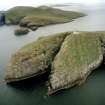
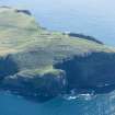
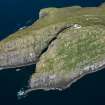
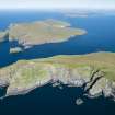
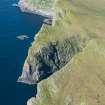
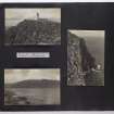
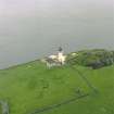
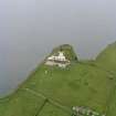
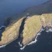
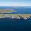
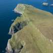
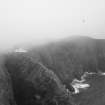
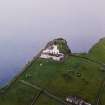
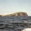
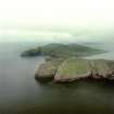
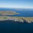
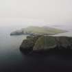
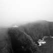
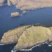
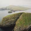
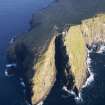
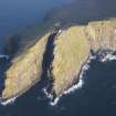
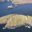
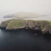
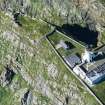
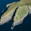
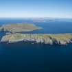
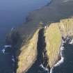
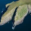
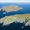
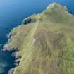
The final stepping stone in the Hebridean archipelago, with 190m high cliffs and sprayswept Barra Head at its southernmost point. Round the principal settlement area on the island's north-east coast, and on the south side of its central ridge, archaeological evidence points to sites of Neolithic, Bronze Age, Iron Age and Norse vintage. No trace survives of a chapel, but an early medieval cross-marked slab lies in the burial ground just south of Maclean's Point. Berneray's population reached 28 in 1851; the last native islanders left in 1910.

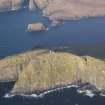
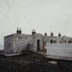
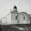
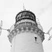
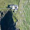
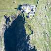
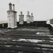
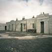
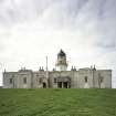
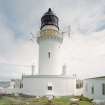
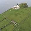
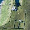
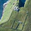
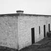
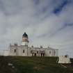
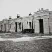
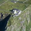
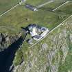
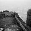
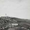
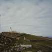
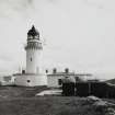
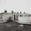
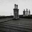
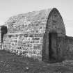
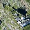
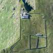
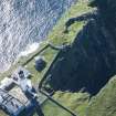
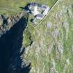
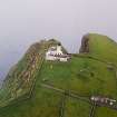
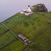
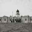
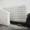
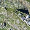
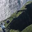
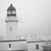
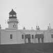
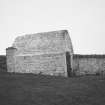
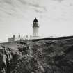
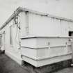
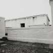
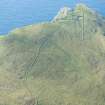
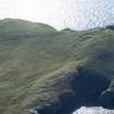
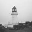
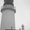
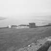
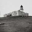
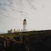
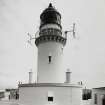
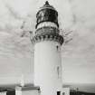
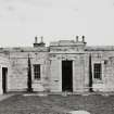
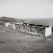
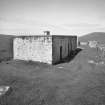
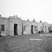
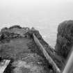
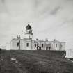
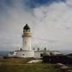
A half mile haul up Mullach a' Lusgan, and the Lighhouse keepers' graveyard lies near the cliff top, ringed by a massive wall. Barra Head Lighthouse, Robert Stevenson, 1830-33 , built by James Smith of Inverness Virtually identical to that at Hynish on Tiree, the granite lighthouse breasts the promontory of Sron an Duin, raising its light 580 ft above the Atlantic surge. Across the cobbled courtyard (which in severe gales can be almost impossible to cross, and into which fish are sometimes blown) stands the low, flat-roofed terrace of keepers' cottages. Graded in status, they might be in Edinburgh's New Town, such is the quality of their joinery: a curved door, fluted architraves, cornices, shutters and fielded panelling. Lighthouse automated in 1980.

Taken from "Western Seaboard: An Illustrated Architectural Guide", by Mary Miers, 2008. Published by the Rutland Press http://www.rias.org.uk

Archaeology Notes

NL58SW 7.00 54898 80253

Barra Head Lighthouse [NAT]

OS 1:10,000, 1989.

For building at NL5655 8036, see also NL58SE 44.

BY18: Lit 1833, engineer Robert Stevenson, became automated 1980.

R W Munro 1979; K Allardyce and E M Hood 1986; NMRS MS/595/7.

Name: Barra Head (1830-3)

Location: N56 47 W7 39 Atlantic, W end of Berneray

Designed and built: Robert Stevenson

Light first exhibited: 15 October 1833

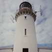
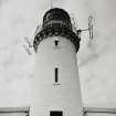
Description: circular stone tower, painted white

Height of light above MHW: 682ft (208m)

Height of tower: 59ft (18m)

Light source and characteristics: W Fl (1) ev 15 secs. Electricity: 162,000 cp: 21nm nominal range

Fog warning apparatus: None

Manning: unwatched (automatic since 23 October 1980)

The highest elevation of any British lighthouse. Electric light replaced the acetylene burner in September 1993

C Nicholson 1995.

This stone-built island lighthouse was constructed in 1833, Robert Stevenson being the engineer and James Smith (Inverness) the contractor. It was automated in 1980. When constructed, this was both the highest (683ft asl) and the most fog-bound of all the Northern Lighthouse Board lights. Hot water pipes were installed to heat the lantern in winter.

The lighthouse-keepers' houses (NL58SW 7.01) are adjacent, and the associated shore facilities were at Oban (Pulpit Hill).

Information from RCAHMS (RJCM), 26 August 2008.

R W Munro 1979; K Allardyce and E M Hood 1986; K Allardyce 1998; S Krauskopf 2001.

Architecture Notes

EXTERNAL REFERENCE

Scottish Records Office

The Commissioners announce their intention to build 3 new lighthouses, Dunnet Head, Barra Head and S. side of Lismore. Letter from C. Cunninghame says the commissioners have resolved to delay decision on Chickenhead

(Stornoway)

1829 GD46/17/77

Activities

Construction (1833)

Light established in 1833.

K Allardyce 1998

Modification (23 October 1980)

Automated in 1980.

K Allardyce 1998

Aerial Photography (3 July 2003)

References

MyCanmore Image Contributions


Contribute an Image

MyCanmore Text Contributions