
Pricing Change
New pricing for orders of material from this site will come into place shortly. Charges for supply of digital images, digitisation on demand, prints and licensing will be altered.
Aerial Photography


Date 3 July 2003
Event ID 576952
Category Recording
Type Aerial Photography
Permalink http://canmore.org.uk/event/576952
Ordnance Survey licence number AC0000807262. All rights reserved.
Canmore Disclaimer.
© Bluesky International Limited 2025.
|
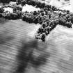
Mingulay, St Columba's Chapel And Graveyard
Burial Ground (Medieval), Chapel (Medieval)
Canmore ID 21359 |
|
|
Gogar Station Road, Millburn Policies, Gogar Stables
Stable(S) (19th Century)
Canmore ID 50694 |
|
|
Doon Hill
Enclosed Settlement (Later Prehistoric), Unenclosed Settlement (Later Prehistoric)
Canmore ID 57651 |
|

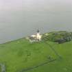
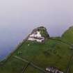
SC 875373
Oblique aerial view centred on the lighthouse with the remains of the dun adjacent, taken from the NNE .
RCAHMS Aerial Photography
3/7/2003
© Crown Copyright: HES

SC 875382
Oblique aerial view centred on the remains of the township with the remains of the chapel house adjacent, taken from the NE.
RCAHMS Aerial Photography
3/7/2003
© Crown Copyright: HES

SC 875389
General oblique aerial view of the remains of the crofting strips, head-dykes and field enclosures, taken from the S.
RCAHMS Aerial Photography
3/7/2003
© Crown Copyright: HES

SC 906346
General oblique aerial view centred on the remains of the building and walling, taken from the ESE.
RCAHMS Aerial Photography
3/7/2003
© Crown Copyright: HES

SC 906348
Oblique aerial view centred on the remains of the roundhouses and buildings with the enclosures and lazy beds adjacent, taken from the NE.
RCAHMS Aerial Photography
3/7/2003
© Crown Copyright: HES

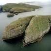
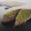
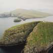
SC 906354
General oblique aerial view centred on the remains of the promontory fort, with coastal promontories and sea stacks adjacent, taken from the S.
RCAHMS Aerial Photography
3/7/2003
© Crown Copyright: HES

SC 973255
Scanned image of oblique aerial view centred on the cropmarks of the pit-alignment with the cropmarks of the square pit and the rig and the farmsteading adjacent, taken from the SSW.
RCAHMS Aerial Photography
3/7/2003
© Crown Copyright: HES

SC 1018792
Oblique aerial view centred on the cropmarks of the fort, taken from the ESE.
RCAHMS Aerial Photography
3/7/2003
© Crown Copyright: HES

SC 1056442
Skipisdale, Mingulay, oblique aerial view centred on the remains of the roundhouse, buildings, field banks and lazy beds, with the settlement mound adjacent and a peat stack stand in the foreground, taken from the E.
RCAHMS Aerial Photography
3/7/2003
© Crown Copyright: HES

SC 1056443
Skipisdale, Mingulay, oblique aerial view centred on the remains of the roundhouses and buildings with the enclosures and lazy beds adjacent, taken from the E.
RCAHMS Aerial Photography
3/7/2003
© Crown Copyright: HES

SC 1056444
General oblique aerial view centred on the remains of Dun Mhiughlaigh promontory fort, Mingulay, with coastal promontories and sea stacks adjacent, taken from the SSW.
RCAHMS Aerial Photography
3/7/2003
© Crown Copyright: HES

SC 1056445
General oblique aerial view centred on the remains of the building and walling, taken from the SE.
RCAHMS Aerial Photography
3/7/2003
© Crown Copyright: HES

SC 1056452
Oblique aerial view centred on Barra Head lighthouse, Berneray, with the remains of the dun adjacent, taken from the ENE.
RCAHMS Aerial Photography
3/7/2003
© Crown Copyright: HES

SC 1056453
Oblique aerial view centred on Barra Head lighthouse, Berneray, with the remains of the dun adjacent, taken from the NE.
RCAHMS Aerial Photography
3/7/2003
© Crown Copyright: HES

SC 1056454
Oblique aerial view of Barra Head lighthouse, Berneray, with the island of Mingulay and those to the N in the background, taken from the SSW.
RCAHMS Aerial Photography
3/7/2003
© Crown Copyright: HES

SC 1056455
Oblique aerial view of Barra Head lighthouse, Berneray, with the island of Mingulay and those to the N in the background, taken from the SSW.
RCAHMS Aerial Photography
3/7/2003
© Crown Copyright: HES

SC 1056456
Oblique aerial view centred on the remains of the shieling mound, taken from the N.
RCAHMS Aerial Photography
3/7/2003
© Crown Copyright: HES

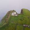
SC 1056457
Mingulay, oblique aerial view centred on the remains of the township with the remains of the chapel house and the schoolhouse and schoolroom adjacent, taken from the NE.
RCAHMS Aerial Photography
3/7/2003
© Crown Copyright: HES

SC 1056458
Mingulay, oblique aerial view centred on the remains of the township with the remains of the chapel and graveyard adjacent, taken from the WNW.
RCAHMS Aerial Photography
3/7/2003
© Crown Copyright: HES

SC 1056459
Mingulay, oblique aerial view centred on the remains of the township with the remains of the chapel and graveyard adjacent, taken from the NE.
RCAHMS Aerial Photography
3/7/2003
© Crown Copyright: HES

SC 1056460
Mingulay, oblique aerial view centred on the remains of the township with the remains of the chapel house adjacent, taken from the SW.
RCAHMS Aerial Photography
3/7/2003
© Crown Copyright: HES

SC 1056461
Mingulay, oblique aerial view centred on Aneir school and enclosure with the remains of the farmsteads and field-system adjacent, taken from the SSW.
RCAHMS Aerial Photography
3/7/2003
© Crown Copyright: HES

SC 1056467
Mingulay, oblique aerial view centred on Aneir school and enclosure with the remains of the trackway and township adjacent, taken from the SW.
RCAHMS Aerial Photography
3/7/2003
© Crown Copyright: HES

SC 1056468
Mingulay, oblique aerial view centred on Aneir school and enclosure with the remains of the trackway, township and field-system and chapel house adjacent, taken from the S.
RCAHMS Aerial Photography
3/7/2003
© Crown Copyright: HES

SC 1056469
Mingulay, oblique aerial view centred on the remains of the chapel house and enclosure with the remains of the township, chapel and graveyard and the school and schoolroom adjacent, taken from the NW.
RCAHMS Aerial Photography
3/7/2003
© Crown Copyright: HES

SC 1056470
Mingulay bay, oblique aerial view centred on the remains of the chapel house and enclosure, taken from the NW.
RCAHMS Aerial Photography
3/7/2003
© Crown Copyright: HES

SC 1056471
Mingulay, oblique aerial view centred on the remains of the chapel house and enclosure with the remains of the township, chapel and graveyard and the school and schoolroom adjacent, taken from the WNW.
RCAHMS Aerial Photography
3/7/2003
© Crown Copyright: HES

SC 1056472
Mingulay, oblique aerial view of the remains of the crofting strips, head-dykes and field enclosures, taken from the N.
RCAHMS Aerial Photography
3/7/2003
© Crown Copyright: HES

SC 1596417
Oblique aerial view centred on the cropmarks of the deserted medieval village, taken from the NW.
RCAHMS Aerial Photography
3/7/2003
© Crown Copyright: HES

SC 1596418
Oblique aerial view centred on the cropmarks of the deserted medieval village, taken from the W.
RCAHMS Aerial Photography
3/7/2003
© Crown Copyright: HES

SC 1596419
Oblique aerial view centred on the cropmarks of the deserted medieval village, taken from the SW.
RCAHMS Aerial Photography
3/7/2003
© Crown Copyright: HES

SC 1596416
Oblique aerial view centred on the cropmarks of the deserted medieval village, taken from the E.
RCAHMS Aerial Photography
3/7/2003
© Crown Copyright: HES

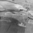
SC 1667725
Oblique aerial view centred on the quarry with the village adjacent, taken from the S.
RCAHMS Aerial Photography
3/7/2003
© Crown Copyright: HES

SC 1667726
Oblique aerial view centred on the quarry with the village adjacent, taken from the SSE.
RCAHMS Aerial Photography
3/7/2003
© Crown Copyright: HES

SC 1667727
Oblique aerial view centred on the quarry, taken from the SE.
RCAHMS Aerial Photography
3/7/2003
© Crown Copyright: HES

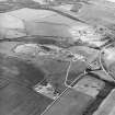
SC 1667952
Oblique aerial view centred on the castle, tower-house and country house with the stables, tower and walled garden adjacent, taken from the SE.
RCAHMS Aerial Photography
3/7/2003
© Crown Copyright: HES

SC 1667953
Oblique aerial view centred on the castle, tower-house and country house with the tower and walled garden adjacent, taken from the NE.
RCAHMS Aerial Photography
3/7/2003
© Crown Copyright: HES

SC 1667954
Oblique aerial view centred on the castle, tower-house and country house with the tower and walled garden adjacent, taken from the NNW.
RCAHMS Aerial Photography
3/7/2003
© Crown Copyright: HES

SC 1667955
Oblique aerial view centred on the castle, tower-house and country house with the tower and walled garden adjacent, taken from the NNE.
RCAHMS Aerial Photography
3/7/2003
© Crown Copyright: HES

SC 1667956
Oblique aerial view centred on the castle, tower-house and country house with the stables, tower and walled garden adjacent, taken from the NW.
RCAHMS Aerial Photography
3/7/2003
© Crown Copyright: HES

SC 1667957
Oblique aerial view centred on the castle, tower-house and country house with the stables, tower and walled garden adjacent, taken from the S.
RCAHMS Aerial Photography
3/7/2003
© Crown Copyright: HES

SC 1667958
Oblique aerial view centred on the castle, tower-house and country house with the stables, tower and walled garden adjacent, taken from the SE.
RCAHMS Aerial Photography
3/7/2003
© Crown Copyright: HES

SC 1680131
Oblique aerial view centred on the cement works and quarry, taken from the NE.
RCAHMS Aerial Photography
3/7/2003
© Crown Copyright: HES

SC 1680132
Oblique aerial view centred on the cement works and quarry, taken from the NNE.
RCAHMS Aerial Photography
3/7/2003
© Crown Copyright: HES

SC 1680133
Oblique aerial view centred on the cement works and quarry with the trial excavations adjacent, taken from the NNW.
RCAHMS Aerial Photography
3/7/2003
© Crown Copyright: HES

SC 1680134
Oblique aerial view centred on the cement works and quarry with the trial excavations adjacent, taken from the NW.
RCAHMS Aerial Photography
3/7/2003
© Crown Copyright: HES

SC 1680135
Oblique aerial view centred on the cement works and quarry with the trial excavations adjacent, taken from the NW.
RCAHMS Aerial Photography
3/7/2003
© Crown Copyright: HES

SC 1680136
Oblique aerial view centred on the construction of the bridge, taken from the SSW.
RCAHMS Aerial Photography
3/7/2003
© Crown Copyright: HES

SC 1680137
Oblique aerial view centred on the construction of the bridge, taken from the S.
RCAHMS Aerial Photography
3/7/2003
© Crown Copyright: HES

SC 1680138
Oblique aerial view centred on the quarry, taken from the NNW.
RCAHMS Aerial Photography
3/7/2003
© Crown Copyright: HES

SC 1680139
Oblique aerial view centred on the quarry, taken from the NW.
RCAHMS Aerial Photography
3/7/2003
© Crown Copyright: HES

SC 1680968
Oblique aerial view centred on the store, taken from the SSW.
RCAHMS Aerial Photography
3/7/2003
© Crown Copyright: HES

SC 1680969
Oblique aerial view centred on the store, taken from the SSW.
RCAHMS Aerial Photography
3/7/2003
© Crown Copyright: HES

SC 1680970
Oblique aerial view centred on the store, taken from the SE.
RCAHMS Aerial Photography
3/7/2003
© Crown Copyright: HES

SC 1680971
Oblique aerial view centred on the store, taken from the NE.
RCAHMS Aerial Photography
3/7/2003
© Crown Copyright: HES

SC 1681247
Oblique aerial view centred on the quarry with the farmhouse adjacent, taken from the NE.
RCAHMS Aerial Photography
3/7/2003
© Crown Copyright: HES

SC 1681248
Oblique aerial view centred on the quarry with the farmhouse adjacent, taken from the NNE.
RCAHMS Aerial Photography
3/7/2003
© Crown Copyright: HES

SC 1681249
Oblique aerial view centred on the road construction and the quarry, with the farmhouses, farmsteading and cottages adjacent, taken from the SE.
RCAHMS Aerial Photography
3/7/2003
© Crown Copyright: HES

SC 1681250
Oblique aerial view centred on the road construction and the quarry, with the farmhouses, farmsteading and cottages adjacent, taken from the ESE.
RCAHMS Aerial Photography
3/7/2003
© Crown Copyright: HES

SC 1681251
Oblique aerial view centred on the road construction with the quarry, farmhouse, farmsteading and cottages adjacent, taken from the E.
RCAHMS Aerial Photography
3/7/2003
© Crown Copyright: HES

SC 1681252
Oblique aerial view centred on the road construction with the quarry, farmhouse, farmsteading and cottages adjacent, taken from the ENE.
RCAHMS Aerial Photography
3/7/2003
© Crown Copyright: HES

SC 1681253
Oblique aerial view centred on the road construction with the quarry, farmhouse, farmsteading and cottages adjacent, taken from the ENE.
RCAHMS Aerial Photography
3/7/2003
© Crown Copyright: HES

SC 1698831
General oblique aerial view of the remains of the head-dyke and field enclosures with the remains of the chapel house adjacent, taken from the ENE .
RCAHMS Aerial Photography
3/7/2003
© Crown Copyright: HES

SC 1698832
General oblique aerial view of the remains of the head-dyke and field enclosures with the remains of the chapel house adjacent, taken from the E.
RCAHMS Aerial Photography
3/7/2003
© Crown Copyright: HES

SC 1698833
General oblique aerial view of the remains of the head-dyke and field enclosures, taken from the NE.
RCAHMS Aerial Photography
3/7/2003
© Crown Copyright: HES

SC 1698834
Oblique aerial view centred on the remains of the roundhouse with the field-system and lazy beds adjacent, taken from the SSE.
RCAHMS Aerial Photography
3/7/2003
© Crown Copyright: HES

SC 1698835
Oblique aerial view centred on the remains of the roundhouse with the field-system and lazy beds adjacent, taken from the SSE.
RCAHMS Aerial Photography
3/7/2003
© Crown Copyright: HES

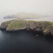
SC 1698836
General oblique aerial view centred on the remains of the promontory fort, with coastal promontories and sea stacks adjacent, taken from the SW.
RCAHMS Aerial Photography
3/7/2003
© Crown Copyright: HES

SC 1698837
Oblique aerial view centred on the remains of a field system and buildings on the E slopes of Hecla on Mingulay, taken from the ESE.
RCAHMS Aerial Photography
3/7/2003
© Crown Copyright: HES

SC 1698838
Oblique aerial view centred on the remains of buildings and settlement with the lazy beds and field banks adjacent, taken from the ENE.
RCAHMS Aerial Photography
3/7/2003
© Crown Copyright: HES

SC 1698839
Oblique aerial view centred on the remains of the shieling mound, taken from the NE.
RCAHMS Aerial Photography
3/7/2003
© Crown Copyright: HES

SC 1698840
General oblique aerial view centred on the school and enclosure with the remains of the farmsteads and field-system adjacent, taken from the SW .
RCAHMS Aerial Photography
3/7/2003
© Crown Copyright: HES

SC 1698841
General oblique aerial view centred on the school and enclosure with the remains of the farmsteads and field-system adjacent, taken from the SSW .
RCAHMS Aerial Photography
3/7/2003
© Crown Copyright: HES

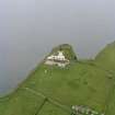
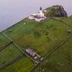
SC 1698842
Oblique aerial view of the lighthouse with the island of Mingulay and those to the N in the background, taken from the SSW.
RCAHMS Aerial Photography
3/7/2003
© Crown Copyright: HES

SC 1698843
Oblique aerial view centred on the remains of the township with the remains of the chapel house adjacent, taken from the SW.
RCAHMS Aerial Photography
3/7/2003
© Crown Copyright: HES

SC 1698844
General oblique aerial view of the remains of the crofting strips, head-dykes and field enclosures, taken from the S.
RCAHMS Aerial Photography
3/7/2003
© Crown Copyright: HES

SC 1698845
General oblique aerial view centred on the school and enclosure with the remains of the trackway and township adjacent, taken from the SW .
RCAHMS Aerial Photography
3/7/2003
© Crown Copyright: HES

SC 1698846
General oblique aerial view centred on the school and enclosure with the remains of the trackway and township adjacent, taken from the SW .
RCAHMS Aerial Photography
3/7/2003
© Crown Copyright: HES

SC 1698847
General oblique aerial view centred on the school and enclosure with the remains of the trackway and township adjacent, taken from the SSE.
RCAHMS Aerial Photography
3/7/2003
© Crown Copyright: HES

SC 1698848
Oblique aerial view centred on the remains of the township with the remains of the chapel and graveyard adjacent, taken from the NE.
RCAHMS Aerial Photography
3/7/2003
© Crown Copyright: HES

SC 1698849
Oblique aerial view centred on the remains of the township with the remains of the chapel house adjacent, taken from the NE.
RCAHMS Aerial Photography
3/7/2003
© Crown Copyright: HES

SC 1698850
Oblique aerial view centred on the remains of the chapel house and enclosure, taken from the NW.
RCAHMS Aerial Photography
3/7/2003
© Crown Copyright: HES

SC 1698851
General oblique aerial view centred on the remains of the chapel house and enclosure with the remains of the township, chapel and graveyard and the school and schoolroom adjacent, taken from the N.
RCAHMS Aerial Photography
3/7/2003
© Crown Copyright: HES

SC 1698852
General oblique aerial view centred on the remains of the chapel house and enclosure with the remains of the township, chapel and graveyard and the school and schoolroom adjacent, taken from the NW.
RCAHMS Aerial Photography
3/7/2003
© Crown Copyright: HES

SC 1698853
General oblique aerial view of the remains of the crofting strips, head-dykes and field enclosures, taken from the N.
RCAHMS Aerial Photography
3/7/2003
© Crown Copyright: HES

SC 1698854
General oblique aerial view of the remains of the crofting strips, head-dykes and field enclosures, taken from the S.
RCAHMS Aerial Photography
3/7/2003
© Crown Copyright: HES

SC 1698855
General oblique aerial view centred on the remains of the promontory fort, with coastal promontories and sea stacks adjacent, taken from the SSW.
RCAHMS Aerial Photography
3/7/2003
© Crown Copyright: HES

SC 1698859
Oblique aerial view centred on the remains of the roundhouses and buildings with the enclosures and lazy beds adjacent, taken from the NE.
RCAHMS Aerial Photography
3/7/2003
© Crown Copyright: HES

SC 1698860
Oblique aerial view centred on the remains of the roundhouse, buildings, field banks and lazy beds, with the settlement mound adjacent, taken from the E.
RCAHMS Aerial Photography
3/7/2003
© Crown Copyright: HES

SC 1698861
Oblique aerial view centred on the remains of the roundhouse, buildings, field banks and lazy beds, with the settlement mound adjacent and a peat stack stand in the foreground, taken from the NE.
RCAHMS Aerial Photography
3/7/2003
© Crown Copyright: HES

SC 1698862
Oblique aerial view centred on the remains of the roundhouses and buildings with the enclosures and lazy beds adjacent, taken from the NE.
3/7/2003
© RCAHMS

SC 1698863
Oblique aerial view centred on the remains of the roundhouses and buildings with the enclosures and lazy beds adjacent, taken from the N.
RCAHMS Aerial Photography
3/7/2003
© Crown Copyright: HES

SC 1698864
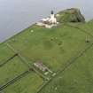
Oblique aerial view centred on the lighthouse with the remains of the dun adjacent, taken from the E.
RCAHMS Aerial Photography
3/7/2003
© Crown Copyright: HES

SC 1698865
Oblique aerial view centred on the lighthouse with the remains of the dun adjacent, taken from the ENE.
RCAHMS Aerial Photography
3/7/2003
© Crown Copyright: HES

SC 1698866
Oblique aerial view centred on the lighthouse with the remains of the dun adjacent, taken from the NE.
RCAHMS Aerial Photography
3/7/2003
© Crown Copyright: HES

SC 1698867
General oblique aerial view of the lighthouse with the island of Mingulay and those to the N in the background, taken from the SSW .
RCAHMS Aerial Photography
3/7/2003
© Crown Copyright: HES

SC 1698869
General oblique aerial view of the lighthouse with the island of Mingulay and those to the N in the background, taken from the S.
RCAHMS Aerial Photography
3/7/2003
© Crown Copyright: HES

SC 1733137
Oblique aerial view centred on the cropmark of the ring-ditch with the stables and country house adjacent, taken from the ENE.
RCAHMS Aerial Photography
3/7/2003
© Crown Copyright: HES

SC 1733138
Oblique aerial view centred on the cropmark of the ring-ditch, taken from the N.
RCAHMS Aerial Photography
3/7/2003
© Crown Copyright: HES

SC 1733139
Oblique aerial view centred on the cropmark of the ring-ditch, taken from the NW.
RCAHMS Aerial Photography
3/7/2003
© Crown Copyright: HES


First 100 images shown.

Archive from cultural heritage assessment and archaeological assessment, Gogarburn Sustainable Development Framework, Edinburgh
Oblique aerial view centred on the lighthouse with the remains of the dun adjacent, taken from the NNE .
Oblique aerial view centred on the remains of the township with the remains of the chapel house adjacent, taken from the NE.
