
Mingulay, St Columba's Chapel And Graveyard


Burial Ground (Medieval), Chapel (Medieval)
Site Name Mingulay, St Columba's Chapel And Graveyard
Classification Burial Ground (Medieval), Chapel (Medieval)
Canmore ID 21359
Site Number NL58SE 2
NGR NL 5649 8329
Datum OSGB36 - NGR
Permalink http://canmore.org.uk/site/21359


- Council Western Isles
- Parish Barra
- Former Region Western Isles Islands Area
- Former District Western Isles
- Former County Inverness-shire
NL58SE 2 5649 8329
For (surrounding) Mingulay village, see NL58SE 16.
(NL 5649 8328) St Columba's Chapel (NR) (Site of)
OS 6" map, Inverness-shire, 2nd ed., (1904)
Supposed site of St Columba's Chapel, with graveyard (T S Muir 1885). Muir, about 1885, enquired about the existence of a chapel on Mingulay. The correspondent replied that the burial ground was in a ruinous condition, and the "oldest inhabitant" did not know of one.
Name Book 1878; T S Muir 1885.
No trace of chapel was found. The burial ground, a sandy knoll enclosed by a low wall of boulders, contains a few modern head stones and crosses, and is slowly being covered by drifting sand.
Visited by OS (W D J) 19 May 1965.
What appears to be the remains of the chapel are visible on the summit of the knoll. It consists of the W end of a rectangular building, 3.0m long and up to three courses high. Further details are obscured by blown sand.
Visited by OS (D W R) 30 August 1973.
Field Visit (10 June 1915)
St Columba's Chapel, Mingulay.
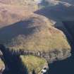
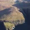
No traces of St Columba's Chapel are to be seen. It stood above the shore at the north-west corner of Mingulay Bay, a sandy bay on the east side of the island.
RCAHMS 1928, visited 10 June 1915.
OS map: Barra lxx.
Field Visit (4 April 2003)
The medieval chapel of St Columba and the surrounding graveyard are situated to the E of the township of Mingulay immediately N of the burn that runs through the township, and are partly inundated by sand. A section of its foundations are visible at the NW corner of the sand-covered mound and are well-constructed in stone. It probably measures at least 10.4m from E to W by 4.8m transversely over walls up to 1.6m in thickness and 0.6m in height. The surrounding graveyard is roughly oval and is enclosed by a drystone wall, which is deeply covered by sand on the NE. The tips of eight gravestones were visible projecting from the sand to the S of the chapel and also a concrete slab with a crosshead. This site has been recorded by Buxton (1981) and latterly by Branigan and Foster (2000).
MING03 228
Visited by RCAHMS (PJD) 4 April 2003

