
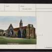
Fortrose, Cathedral Square, Fortrose Cathedral


Cathedral (13th Century)
Site Name Fortrose, Cathedral Square, Fortrose Cathedral
Classification Cathedral (13th Century)
Alternative Name(s) Cathedral Of The Bishops Of Ross
Canmore ID 14324
Site Number NH75NW 1
NGR NH 72705 56522
Datum OSGB36 - NGR
Permalink http://canmore.org.uk/site/14324


First 100 images shown. See the Collections panel (below) for a link to all digital images.
- Council Highland
- Parish Rosemarkie
- Former Region Highland
- Former District Ross And Cromarty
- Former County Ross And Cromarty
NH75NW 1.00 72705 56522
(NH 7270 5652) Cathedral (NR)
OS 6" map, (1959)
NH75NW 1.01 NH 727 564 Manse
NH75NW 1.02 NH 72737 56536 Chapter House (Court House)
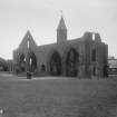
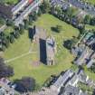
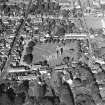
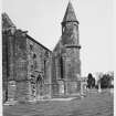
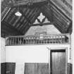
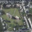
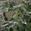
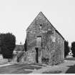
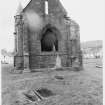
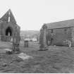
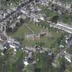
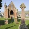
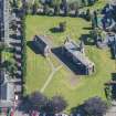
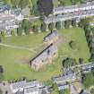
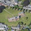
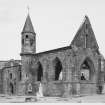
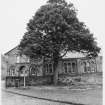
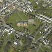
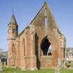
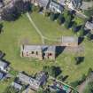
The cathedral of the Bishops of Ross, dedicated to SS Peter and Curitan, was transferred from Rosemarkie (NH75NW 7) to Fortrose about 1235. Of the building of this period only the undercroft of the Chapter-house remains; the upper storey of which was rebuilt in the 19th century as a Court-house. All other remains date apparently from the late 14th and early 15th centuries and consist of the vaulted south aisle of the nave, and the bell-tower. The ground plan was recovered about 1870 by an excavation by H.M. Commissioners of Woods & Forests.
The cathedral fell into disrepair about the time of the Reformation, but was partially repaired in 1615 and by 1649 was not very ruinous. Traditions says that Cromwell subsequently removed most of the masonry.
D MacGibbon and T Ross 1896-7; A R Scott 1873.
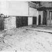
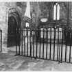
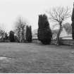
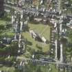
The remains of the cathedral are as described above. The area of the nave is defined by shale and only a few base stones of the buttresses remain. The graveyard to the S is still used occasionally, the extant portion of the Cathedral has recently been re-roofed.
Visited by OS (N K B) 9 March 1966.
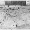
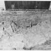
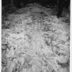
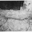
NH 7271 5652. A series of excavations and a watching brief were carried out by Kirkdale Archaeology at Fortrose Cathedral in February and March 1996. The aim of the project was to establish whether the landscaped layout presently in place accurately reflects the location of the buried elements of the cathedral structure.
The extent of surviving remains was patchy, with noticeably superior masonry revealed towards the W end of the site, perhaps indicating the assumed two-phased construction programme between the nave and the choir.
Sponsor: Historic Scotland
G Ewart and D Stewart 1996.
NH 727 565 A Ground Penetrating Radar (GPR) survey was carried out in February 2006 within the surviving South Aisle building (c 2 x 25m) of Fortrose Cathedral, which is situated on the Black Isle approximately 15 miles N of Inverness. The vaulted ceiling of the South Aisle will need to be supported during replacement of the building's existing wall ties. GPR was undertaken with the aim of identifying any large voids beneath the floor to assist with the placement of equipment when propping the ceiling.
Survey was undertaken using a GSSI 3000 GPR system with a 400MHz antenna. The near data are dominated by responses from the paved surface of the floor of the South Aisle with coherent reflections corresponding with tombstones visible on the floor. In the deeper time-slices several reflections suggesting subterranean changes are apparent. The primary area of concern is at the gated entrance of the cathedral, with strong reflections suggesting possible voids or at least potentially disturbed ground/unconsolidated material. Two possible 'coffins' have been located. However, both of these lie beneath tombstones, which will not be used to prop the roof. There are also indications of a possible structure along the southern limit of the survey area, adjacent to the cathedral wall.
Archive lodged with the Geophysics Unit, Orkney College, Kirkwall, Orkney, KW15 1LX.
Sponsor: Historic Scotland.
Susan Ovenden, 2006.
REFERENCE: SCOTTISH RECORD OFFICE
Rough sketch showing the position of the Cathedral, Manse and crofts of the Dean and Chapter of Ross.
1859 GD128/30/7/1
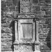
The condition of the Cathedral and the Seaforth Tomb.
Roderick MacFarquhar comments on this in a letter which accompanies an estimate for enclosing the churchyard with a wall and providing a gate and pillars.
1825 GD45/12/7
Estimate for enclosing the churchyard surrounding the Cathedral with a wall and the addition of a gate and pillars. Letter from Roderick MacFarquhar, Fortrose, comments on condition of the Cathedral cna the Seaforth Tomb.
1825 GD45/12/7
REFERENCE: NATIONAL LIBRARY OF SCOTLAND
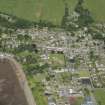
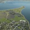
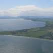
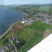
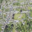
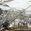
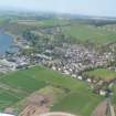
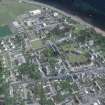
Fortrose is a small town in the Black Isle, Ross-shire, on the North side of the inner part of the Moray Firth, nearly opposite Fort George. It is situated ten and a half miles North East of Inverness. It was the Cathedral Town of the Bishoprie of Ross. A very small part of the ancient Cathedral yet remains entire. The National Library of Scotland, Edinburgh contains, among the "Uncatalogued MSS of General Hutton", and numbered 134 in Vol 1, an external view of 1815 and an internal view of the Chapter House dated 1819.
NLS Advocates' MS 30.5.23, 133-39. Architectural drawings, mainly of 1815 (inc. plans by John MacQueen), and Scott (1873).
BIBLIOGRAPHIC REFERENCE: NMRS LIBRARY
Scottish Magazine August 1933
(Undated) information in NMRS.
Field Visit (June 1979)
Fortrose NH 725 564 NH75NW 1 & 19
Fortrose was annexed to Rosemarkie and erected a royal burgh in 1455; in 1661 the rights of the united burgh were transferred to Fortrose. The medieval cathedral of Ross (NH 727 565) is in state guardianship; nothing can now be seen of Seaforth Castle, which is traditionally located at NH 727 567.
RCAHMS 1979, visited June 1979
NSA, xiv (Ross and Cromarty), 353; MacGibbon and Ross 1896-7, ii, 394-402; Pryde 1965, 28-30, no. 64
Graveyard Survey (15 June 1985 - 22 June 1985)
Over the course of 1985, Kirkdale Archaeology carried out a number of graveyard surveys in the northeast of Scotland. The graveyard of Fortrose Cathedral was recorded as a part of this project.
Sponsor: Historic Buildings and Monuments
Kirkdale Archaeology
Publication Account (1995)
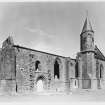
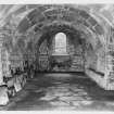
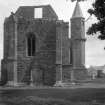
Of the medieval cathedral of the diocese of Ross only the south aisle and chapel and the chapter house now remain as separate buildings, but the plan of the foundations is laid out in the grass.
The bishopric of Ross was originally at Rosemarkie, but Bishop Robert (1214-49) moved to Fortrose and started to build a new cathedral. The choir, chancel and chapter house may have been finished by the end of the 13th century, but work probably ceased during the Wars of Independence,and the building was only completed in the early 15th century. After the Reformation the Regent Moray allowed the lead to be stripped from the roof, while Cromwell is said to have taken the fallen stones, as he did at Beauly, to build his fortress at Inverness.
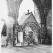
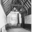
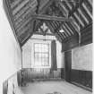
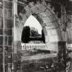
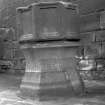
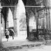
The cathedral was a long rectangle with heavily buttressed walls and a west tower. The most important surv iving structure is the south nave aisle, added in the late 14th-early 15th century, of which the eastern section was traditionally erected as a chantry chapel and burial aisle for Euphemia, Countess of Ross in her own right, who died in 1395. Her first husband was Sir WaIter Leslie, whose arms appear on a roof boss. Ironically, her second husband was that Alexander Stewart, Wolf of Badenoch, who with 'wild Wykked Heland-men' burnt Elgin cathedral and Burgh in 1390. The tracery of the wi ndows in her chapel at Fortrose is similar to that of the new windows put in th e choir aisles at Elgin after the fire. The ribbed vaulting of the aisle roof is particu larly fine. Between the aisle and the nave are three arched tombs: from east to west, these are traditionally those of Countess Euphemia herself, Bishop Cairncross (1539-45) and Bishop Fraser (1489-1507). It is curious that a bishop's head is carved on the Countess's tomb. Halfway along the south aisle is an octagonal stair tower and bell turret with a Victorian pointed roof. Only the chapter house preserves any portion of the original 13th-century cathedral: the vaulted undercroft of this building, located next to the ha chancel, was probably a combined chapter house and sacristy (where the priests prepared for the services), while the room above may have housed the cathedral library and a treasury.
Information from ‘Exploring Scotland’s Heritage: The Highlands’, (1995).
Excavation (19 February 1996 - 27 February 1996)
NH 7271 5652. A series of excavations and a watching brief were carried out by Kirkdale Archaeology at Fortrose Cathedral in February and March 1996. The aim of the project was to establish whether the landscaped layout presently in place accurately reflects the location of the buried elements of the cathedral structure.
The extent of surviving remains was patchy, with noticeably superior masonry revealed towards the W end of the site, perhaps indicating the assumed two-phased construction programme between the nave and the choir.
G Ewart and D Stewart 1996
Sponsor: Historic Scotland
Kirkdale Archaeology
Ground Penetrating Radar (February 2006)
NH 727 565 A Ground Penetrating Radar (GPR) survey was carried out in February 2006 within the surviving South Aisle building (c 2 x 25m) of Fortrose Cathedral, which is situated on the Black Isle approximately 15 miles N of Inverness. The vaulted ceiling of the South Aisle will need to be supported during replacement of the building's existing wall ties. GPR was undertaken with the aim of identifying any large voids beneath the floor to assist with the placement of equipment when propping the ceiling.
Survey was undertaken using a GSSI 3000 GPR system with a 400MHz antenna. The near data are dominated by responses from the paved surface of the floor of the South Aisle with coherent reflections corresponding with tombstones visible on the floor. In the deeper time-slices several reflections suggesting subterranean changes are apparent. The primary area of concern is at the gated entrance of the cathedral, with strong reflections suggesting possible voids or at least potentially disturbed ground/unconsolidated material. Two possible 'coffins' have been located. However, both of these lie beneath tombstones, which will not be used to prop the roof. There are also indications of a possible structure along the southern limit of the survey area, adjacent to the cathedral wall.
Archive lodged with the Geophysics Unit, Orkney College, Kirkwall, Orkney, KW15 1LX.
Sponsor: Historic Scotland.
S Ovenden 2006
Watching Brief (11 March 2013 - 12 March 2013)
NH 7270 5655 (centred on) A watching brief was undertaken, 11–12 March 2013, during the excavation of three trenches for new signs. The removal of a set of grass bars at each of the existing information boards was also monitored. The work recorded indications of distinct phases of landscaping, including an 1876 ha’penny, found in the small trench excavated immediately SW of the path, S of the entrance gate at the N end of the grounds.
Archive: RCAHMS (intended)
Funder: Historic Scotland
Paul Fox, Kirkdale Archaeology, 2013
(Source: DES)
kirkdale1-311430

