
Dingwall Canal


Canal (19th Century)
Site Name Dingwall Canal
Classification Canal (19th Century)
Alternative Name(s) River Peffery; River Peffray; Cromarty Firth
Canmore ID 12769
Site Number NH55NE 24
NGR NH 5585 5888
NGR Description NH c. 5490 5910 to NH c. 5613 5843
Datum OSGB36 - NGR
Permalink http://canmore.org.uk/site/12769


- Council Highland
- Parish Dingwall
- Former Region Highland
- Former District Ross And Cromarty
- Former County Ross And Cromarty
NH55NE 24.00 c. 5490 5910 to c. 5613 5843
River Peffery [NAT] (name centred NH 5557 5905)
OS 1:10,000 map, 1992.
Extends onto map sheet NH55NW.
Location formerly cited as NH 549 540, and also as NH 5500 5909 to NH 5613 5843.
NH55NE 24.01 NH 55414 59070 Highland Railway Bridge
NH55NE 24.02 NH 56047 58543 Dingwall Harbour Footbridge
NH55NE 24.03 NH c. 5615 5844 Harbour
See also:
NH55NW 182 NH 54931 59091 Dingwall, Tulloch Street, Peter's Bridge
NH55NE 159 NH 56060 58449 Dingwall, Ferry Road, Harbour House
An improvement of the River Peffrey [Peffery] was undertaken in the early nineteenth century as Dingwall found itself to be a sufficiently prosperous burgh to finance this. At a cost of £4, 365 a section of this river was 'diverted into an artificial channel' between 1815 and 1817. The canal only produced an annual revenue of £100. Some years later Telford reported that repairs would cost #800, at which juncture the Town Council applied to the Commissioners for Highland Roads and Bridges to take over responsibility for it. However, these negotiations were fruitless and control of the canal remained in the hands of the burgh.
J Lindsay 1968.
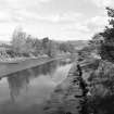
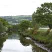
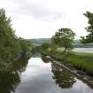
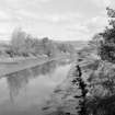
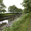
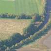
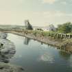
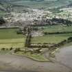
(Location cited as NH 562 584 to NH 550 591). Dingwall Canal, built 1815-17. The artificially-straightened course of the River Peffray [Peffery], with the remains of wooden quays at the seaward end.
J R Hume 1977.
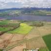
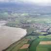
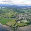
(Location cited as NH 562 585). Dingwall: this town, although not necessarily its harbour, was of sufficient importance in the 1570's for inclusion on Bishop Leslie's map. The burgh charter, obtained in 1587 from James VI, includes references to cobbles and small boats. The anomalous position of the 19th century harbour, nearly a mile from the town (NH55NE 22) and at the end of a man-made canal (NH55NE 24.00) suggests an earlier beach landing close to the settlement, which eventually ceased to fulfil its function as a result of the silting up of the whole head of the firth. Alluvium brough down by the rivers Conon and Orrin seems to have created a reach of tidal islets and backwaters almost all the way from Maryburgh [name: NH 540 561], and associated sands and shallows extend for more than three miles (4.8km) below Dingwall. It is tempting, therefore, to think of the burgesses of Dingwall as engaged in a losing battle with the forces of nature, and finding their beach landing gradually becoming less and less fit for their purpose. The depressed state of the burgh in 1773 when no harbour existed is illustrated by a reference in the Inverness Burgh Records.
Improvement seems only to have come when the canal was cut in 1815-19. Navigable water was reached by deepening and canalising the River Peffery. That the course of this river had already been somewhat rationalised is suggested by a plan of 1777, which, in addition to marking a landing place for boats up to eight tons at the site of the later town harbour, shows the river's lower reach taking a sinuous course past the castle (NH55NE 4), much like that of the later canal. On the plan published by Telford in 1821, the cut into which the Peffery was diverted during construction of the canal is clearly marked, debouching into an area of salt marsh which retained something of the form of the river mouth as it had been before the rationalisation recorded in 1777.
In 1815, Dingwall Town Council Minutes record a contribution of £100 to the building of the canal, which eventually cost £4365. In 1828, another Minute records an effort, which failed, to transfer responsibility for the canal, then earning less than £100 a year and on need of £800 worth of repairs, to the Parliamentary Commissioners. In 1837m the canal was held to constitute a tolerably good harbour quite close to the harbour; two small vessels, built and owned ion the town, were then engaged in the coasting trade, while others came with coal, lime and other cargoes, taking out grain, timber and bark.
Structure.
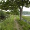
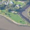
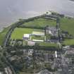
Of the 19th century harbour below the bridge [presumably Peter's Bridge: NH55NW 182] at the head of the canal only a few uneven courses of grey stone blocks are still visible in the face of the right bank. About a quarter of a mile (0.4km) to the E, Old River Road [name: NH 5496 5917] preserves the line of the opposite bank of the swampy river mouth in which boat landings were made before the canal was built. A building known as Harbour House (NH55NE 159) stands on the right [S] bank of the canal near its opening into the Firth. From below Harbour House, the canal mouth was reconstructed in 1861, and now takes a final turn to the SE. A short distance upstream from Harbour House, also on the right bank, there are remains of a timber wharf [NH55NE 24.03]. Seven heavy frontal uprights are in place, as are two front edge timbers, each about 7ft (2.1m) long and a foot (0.304m) square, at the upstream end. It may be that this timber wharf dates only from the construction of the railway bridge (NH55NE 24.01), just below the Castle (NH55NE 4), when the second harbour marked on Telford's plan disappeared.
A Graham and J Gordon 1988.
An alignment of stakes on the Eastern side of the tidal zone of river bank from railway bridge outwards. Visible as closely set posts c10-15cm diameter and discontinuous. Possible bank stabilisation or jetty siding.
At end of river this feature is clearly interpreted as part og canalization of river mouth. Timber posts and sturdy planking revet both banks of river and sturdy planking revets the outer (estuary) side of the Eastern spit. At the mouth of the river modern wire meshed stone reveting replaces earlier timber revetting.
CFA/MORA Coastal Assessment Survey 1998.
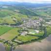
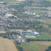
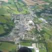
The line of the canal, running from N of the town (NH55NE 22) and heading E then SE to the harbour, is clearly visible on the 1st edition of the OS 6-inch map (Ross-shire 1881, sheet lxxxviii) and on the current edition of the OS 1:10000 map (1992). On the latter map the harbour is marked as disused.
Information from RCAHMS (MD) 25 July 2002.
The location assigned to this record is arbitrary, defining the midpoint of its length. The canal apparently extended from NH c. 5490 5910 to NH c. 5613 5843, its extent being unclear at both ends.
Information from RCAHMS (RJCM), 5 April 2006.
Construction (1815 - 1817)
Built 1815-17. Improvements late 1860s, abandoned from 1884.
R Paxton and J Shipway, 2007.
Publication Account (2007)
Dingwall Canal
(Institute Civil Engineers Historic Engineering Works no. HEW 2545)
This 2000 yard long canal with its two basins and quays connected the Peffrey, Great North Road and town with the Cromarty Firth and was used by vessels of up to 9 ft draught. It was built under the auspices of the Highland Roads Commission from 1815–17 for £3800 by William Hughes, a Caledonian Canal contractor. The engineer was David Wilson.
The canal encountered silting problems throughout its existence and was thought to be finally improved in the late 1860s but, within a decade, it had again fallen into disrepair and became disused from 1884. Nothing is now visible of the works at the town end, but much of the canal channel still exists.
R Paxton and J Shipway, 2007.
Reproduced from 'Civil Engineering heritage: Scotland - Highlands and Islands' with kind permission from Thomas Telford Publishers.

