|
Photographs and Off-line Digital Images |
RC 5188 PO |
Papers of Professor John R Hume, economic and industrial historian, Glasgow, Scotland |
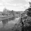
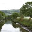
View looking East around NH 554 590 |
1974 |
Item Level |
|
|
Photographs and Off-line Digital Images |
RC 5189 PO |
Papers of Professor John R Hume, economic and industrial historian, Glasgow, Scotland |
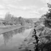
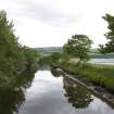
Seaward end of canal, looking South East |
1974 |
Item Level |
|
|
Prints and Drawings |
RCD 31/1 |
|
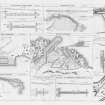
Mechanical copy of drawing showing plans and dimensions of Harbours, Wharfs and Ferry-Piers.
Kirkwall Harbour, Fortrose Harbour, Cullen Harbour, Avoch Harbour, Peterhead Harbour, Portmaholmach Harbour, Channery Point-Ferry Pier, Ballintraed Harbour, Nairn Harbour, Gordoun Harbour, Burgh-head Harbour, Fraserburgh Harbour, Invergordon Ferry Piers, Dingwall Canal, Bamff Harbour, Inverfarigaig Landing-pier, St. Catherines Ferry Pier, Portree Harbour, Corran of Ardgower Pier(West side), East Tarbert Harbour, Kyle Haken S.W. Ferry Pier, Corran of Ardgower Ferry Pier (East side), Feoline Harbour, Kyle Haken N.E. Ferry Pier, Tobermory Harbour, Kyle Rhea Ferry Pier (North side), Small Isles Harbour, Kyle Rhea Fery Pier (South side), Pier for Dornie Ferry.
Titled: 'Plans And Dimensions Of Harbours, Wharfs And Ferry-Piers, Made Or Improved Under
The Direction Of The Commissioners For Highland Roads And Bridges, 1806-1821. Thos. Telford,
Engineer.' |
1806 |
Item Level |
|
|
Print Room |
RC 1212 PO |
|
Historic photograph.
General view.
|
c. 1900 |
Item Level |
|
 |
On-line Digital Images |
SC 435228 |
Papers of Professor John R Hume, economic and industrial historian, Glasgow, Scotland |
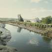
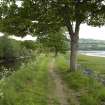
Dingwall, River Peffery, Canal
Seaward end of canal; view of wooden quays. Looking SE |
1974 |
Item Level |
|
 |
On-line Digital Images |
SC 435229 |
Papers of Professor John R Hume, economic and industrial historian, Glasgow, Scotland |
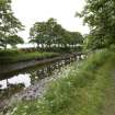
Dingwall, River Peffery, Canal
View looking E at NH 554 590 |
1974 |
Item Level |
|
|
Manuscripts |
MS 726/167 |
Records of CFA Archaeology Ltd, archaeologists, Musselburgh, East Lothian, Scotland |
Coastal Assessment Survey: Inner Moray Firth, Volumes 1 and 2. |
14/12/1998 |
Item Level |
|
 |
On-line Digital Images |
SC 796261 |
Papers of Professor John R Hume, economic and industrial historian, Glasgow, Scotland |
View from N showing canal with NNW and ENE fronts of house in background |
5/1974 |
Item Level |
|
 |
On-line Digital Images |
DP 018083 |
|
Engraving of elevation and plan inscr: ''Plans and Dimensions of Harbours, Wharfs and Ferry-Piers made or improved under the direction of the Commissioner for Highland Roads and Bridges, 1806-1821.'' |
1806 |
Item Level |
|
|
Manuscripts |
MS 2776/1/8 |
Historic Scotland Archive Project |
Survey archive: Site record sheets, site record sheets with field notes and monument forms from the Inner Moray Firth (Moray, Beauly and Cromarty Firth) Coastal Assessment Survey. Sheet 8 and Sheet 9. |
9/1998 |
Item Level |
|
|
Prints and Drawings |
BD 104/1/8 |
Historic Scotland Archive Project |
Survey archive: 1:25,000 OS Pathfinder map depicting site locations from the Moray, Beauly and Cromarty Firth Coastal Assessment Survey. Sheet 8. |
9/1998 |
Item Level |
|
 |
On-line Digital Images |
DP 042849 |
Records of the Royal Commission on the Ancient and Historical Monuments of Scotland (RCAHMS), Edinbu |
View from SSE |
3/6/2008 |
Item Level |
|
 |
On-line Digital Images |
DP 042850 |
Records of the Royal Commission on the Ancient and Historical Monuments of Scotland (RCAHMS), Edinbu |
View from SSE |
3/6/2008 |
Item Level |
|
 |
On-line Digital Images |
DP 042851 |
Records of the Royal Commission on the Ancient and Historical Monuments of Scotland (RCAHMS), Edinbu |
General view from SE |
3/6/2008 |
Item Level |
|
 |
On-line Digital Images |
DP 042852 |
Records of the Royal Commission on the Ancient and Historical Monuments of Scotland (RCAHMS), Edinbu |
View from W |
3/6/2008 |
Item Level |
|
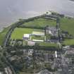 |
On-line Digital Images |
DP 093612 |
RCAHMS Aerial Photography Digital |
Oblique aerial view of the canal, hospital and stadium in Dingwall, looking E. |
24/7/2010 |
Item Level |
|
|
Photographs and Off-line Digital Images |
J 11940 CS |
Papers of Professor Geraint Dyfed Barri Jones, archaeologist, Manchester, England |
Oblique aerial view |
c. 1991 |
Item Level |
|
 |
On-line Digital Images |
SC 1590146 |
Papers of Professor Geraint Dyfed Barri Jones, archaeologist, Manchester, England |
Oblique aerial view |
c. 1991 |
Item Level |
|
 |
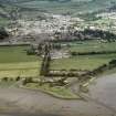
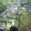
On-line Digital Images |
SC 1906865 |
Papers of James Sloan Bone, landscape historian, Inverness, Highland, Scotland |
Aerial view of Cromarty Firth, looking NW to Dingwall and Ben Wyvis. |
2000 |
Item Level |
|
 |
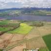
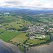
On-line Digital Images |
SC 1970299 |
Papers of James Sloan Bone, landscape historian, Inverness, Highland, Scotland |
Aerial view of Dingwall and Cromarty Firth, Easter Ross, looking SW. |
7/1984 |
Item Level |
|
 |
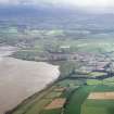
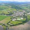
On-line Digital Images |
DP 340612 |
Papers of James Sloan Bone, landscape historian, Inverness, Highland, Scotland |
General aerial view of Dingwall, looking W, towards Strathpeffer. |
9/7/2006 |
Item Level |
|
 |
On-line Digital Images |
DP 340613 |
Papers of James Sloan Bone, landscape historian, Inverness, Highland, Scotland |
General aerial view of Dingwall, looking W, towards Strathpeffer. |
9/7/2006 |
Item Level |
|
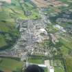 |
On-line Digital Images |
DP 342529 |
Papers of James Sloan Bone, landscape historian, Inverness, Highland, Scotland |
Aerial view of Dingwall, looking W. |
31/8/2011 |
Item Level |
|
 |
On-line Digital Images |
DP 342530 |
Papers of James Sloan Bone, landscape historian, Inverness, Highland, Scotland |
Aerial view of Dingwall, Easter Ross, looking W. |
31/8/2011 |
Item Level |
|


