
Pricing Change
New pricing for orders of material from this site will come into place shortly. Charges for supply of digital images, digitisation on demand, prints and licensing will be altered.
Scheduled Maintenance Notice
Please be advised that this website will undergo scheduled maintenance starting on Thursday, 30th January at 11:00 AM and will last until Friday, 31st January at 10:00 AM.
During this time, the site and certain functions may be partially or fully unavailable. We apologise for any inconvenience this may cause.
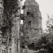
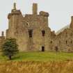
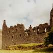
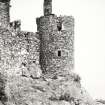
Kilchurn Castle


Castle (Medieval)
Site Name Kilchurn Castle
Classification Castle (Medieval)
Alternative Name(s) Kilcairn Castle, Loch Awe
Canmore ID 23673
Site Number NN12NW 5
NGR NN 13287 27626
Datum OSGB36 - NGR
Permalink http://canmore.org.uk/site/23673


First 100 images shown. See the Collections panel (below) for a link to all digital images.
- Council Argyll And Bute
- Parish Glenorchy And Inishail (Argyll And Bute)
- Former Region Strathclyde
- Former District Argyll And Bute
- Former County Argyll
NN12NW 5 13287 27626.
(NN 1328 2760) Kilchurn Castle (NR)
OS 1:10000 map (1977)
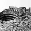
Kilchurn Castle stands on a low peninsula, bounded on the landward side by an artificial ditch about 4.5m wide and 0.6m deep. It comprises a series of buildings ranging in date from about the mid-15th century to about the end of the 17th century.
The earliest is a five storeyed tower house standing at the E corner of the castle, which is known to have been erected by Sir Colin Campbell, who died in 1475. Immediately SW of the tower-house there was probably a small courtyard or barmkin, enclosed by a curtain-wall wall of which considerable remains survive on the S and SE sides.
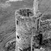
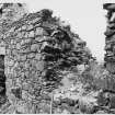
The next building to come on record is the 'laich hall', built by Sir Duncan Campbell (1475-1513). Later documentary information suggests that this structure stood against the inner face of the S curtain, where the foundations of a substantial stone building lie just beneath the turf. Sir Colin Campbell (1550-83) reconstructed the upper storey of the tower-house, and was also responsible for the erection of a building known as the 'north chalmeris', which presumably stood on the NW side of the courtyard; of this, no traces remain. It is recorded that in 1614 the laich hall, together with a kitchen that seems to have occupied the S corner of the courtyard, was rebuilt and raised to a height of two storeys, while two years later a range of buildings comprising two cellars, a loft and a chapel, were built on the SE side of the courtyard. Further extensive repairs are known to have been made to the laich hall and tower-house in 1643. About 1690-98, much of the castle was remodelled and enlarged by the construction of cylindrical angle-towers and of two range of four-storeyed barrack-blocks situated on the NW side of the courtyard.
The castle appears to have been abandoned about the mid-18th century and was unroofed in about 1770, after which the fabric deteriorated rapidly. The building appears to have been extensively patched and consolidated some time after MacGibbon and Ross made their survey (about 1887). This has led to the obliteration or alteration of a number of original features.
RCAHMS 1975, visited 1969; D MacGibbon and T Ross 1887
Kilchurn Castle is generally as described.
Visited by OS (WDJ) 4 May 1970
The domestic offices of Kilchurn Castle stood at NN 132 276. Documentary evidence shows that it had contained a stable, a peathouse, a barn, a byre and both lime and corn kilns. The site was abandoned about 1680 after partial emparkment. The remains of several buildings and a small harbour are visible.
P Hill 1976
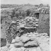
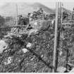
A short programme of trial excavation was completed within the castle, in advance of new drainage within the basements of the two late 17th century barrack blocks. The causes of the present flooding were due initially to the 1690's ranges having been built outside, and consequently with basements below, the natural rocky outcrop which previously defined the fortified circuit. The measures put in places to collect and conduct storm water from the courtyard - a system of downpipes and probably a subfloor drainage channel - are now blocked and broken.
An apparently deliberate gap was left between bedrock and the basement passage wall, in order to trap water seeping beneath the courtyard facing of the barrack block. It is likely that this was linked in some way with the main drain outflow point in the basement beneath the latrines.
Some structural evidence was found of a building lying towards the NW of the 15th-century Towerhouse and which was demolished in advance of the 1690's building programme. It is possible that the section of much robbed walling referred to as the'North Chalmeris'.
Some indication of pre-15th century occupation of the site was found in terms of a mass of fire-reddened and vitrified masonry, some of it recycled as levelling material within the basement. It is therefore possible that some form of drystone rampart existed on the site which has been absorbed by the late 17th-century extensions to the castle on its N and W sides.
Sponsor: HS.
G Ewart 1993.
Argyll, Kilchurn Castle.
This site has only been partially upgraded for SCRAN. For full details, please consult the Architecture Catalogues for Argyll and Bute District.
February 1998
NMRS NOTES
The South side was built at the beginning of the 16th century, and the North side, the largest and most elegant portion, was erected in 1615 by the First Earl of Breadalbane. The entire pile forms an oblong quadrangle with one corner truncated and each of the other towers flanked by round hanging turrets; it is now a roofless ruin.
EXTERNAL REFERENCE
The National Library of Scotland:
Vol 1, no.27, of Watercolour Sketches by Thomas Brown, Advocate, is a view of Kilchurn.
Reference 'Adv. MSS 34.8.1-3'
See under 'Water Colour Sketches, Series of, by Thomas Brown, Advocate'.
EXTERNAL REFERENCES
Scottish Records Office:
Repair of the Castle 'inwardlie and outwardlie' by Sir Duncan Campbell.
Inventory.
Late 16th c. GD 112/22/4
Repair of the Castle.
Andrews Scott of Perth, wright, reroofed the great tower and angle-turrets and repaired the Laich Hall. Receipts.
1643 GD 112/20/5
*Reconstruction of the Castle. Payments made to Andrew Chrystie, mason and to Thomas Williamson, slater. Glenorchy Rental for 1693.
1697 GD 112/9/3
*(Begun 1690 and involved alterations ot the Tower House and the South-East range. Probably the 'North Chalmeris' was removed at this time to allow reconstruction of barracks RCAHMS).
Condition of Castle Kilchurn.
Note by the Earl of Breadalbane's Commissioners that both house and furniture 'are going to decay'. The Officer of Glenorchy is instructed to make out a report on the state of the house.
1726 GD 112/9/41/ page 199
Reconstruction of the Castle.
Payment made to Andrew Chrystie, mason. Charge and discharge cropt 1694.
1695 GD 112/9/5
Reconstruction of the Castle.
Payments made to Andrew Chrystie, mason. Glenorchy Rental for 1697.
1698 GD 112/9/3
Ironwork supplied to strengthen the fabric of the Castle in the case of attack.
Windows of the lower storey were fitted with 'cross stenchers' and some of the next storey had cross barsor gratings. The Chapel and The Old Tower had already been fitted with stenchers and two irongates supplied.
1733 GD 112/40/9
Alterations to the Castle.
Payment of Andrew Chrystie, mason, for his work at the castle during 1692. Letter concerning this from Sir John Campbell of G;enorchy to Alexander Campbell of Balcardine, his chamberlain.
1693 GD 170/629/38
Alterations to the Castle.
The work of the castle is to be continued. Andrew Christie, mason, is to stay there during the winter but Sir John grudges him his food.
Letter from Sir John Campbell of Glenorchy to Alexander CAmpbell of Balcardine.
1692 GD 170/629/37
Major alterations to the Castle.
Agreements, accounts and discharges.
Master mason: Andrew Christy.
Slater: Thomas Williamson
Plasterer: John Kelly
1690-98 GD 170/203/6
Glazier work at the Castle.
Duncan Fisher writes to say that a glazier is available but first he wishes to know how much work there is to doand how many feet of glass will be needed.
Letter to Balcardine or to Andrew Christie.
1699 GD 170/661/4
Alterations to the Castle.
Wright and plasterer work.
John, Lord Glenorchy, asks Andrew Campbell of Balcardine to keep the Wrights and plasterers busy.
Letter.
1699 GD 170/630/12
Repair of the Castle.
Proposed agreement with the Laird of Luss for the supply of timber.
Letter from Sir John Campbell of Glenorchy to Alexander Campbell of Balcardine, his chamberlain.
1689 GD 170/629/17A
Building work at the Castle.
Letter to Andrew Christie, mason. The Earl of Breadalbane writes that he has instructed barcaldine to dispence with the workmen except those required for burrning lime, furnishing timber and working the sawmill.
1695 GD 170/705
GD112/15 Vouchers of Factors Accounts 1643-1997
50/44 Windows with full 'diamons' 1690
57/33 Work by master mason to the Earl of Breadalbane 1694
58/6 Work by master mason to the Earl of Breadalbane 1695
63/21 Work by master mason to the Earl of Breadalbane 1696
64/12 Working at harling the walls 1696
82/6 Glasswork 1701
295/6 'make up several conveniences for the use of the garrison' 1746
NMRS REFERENCE
Views: View by J. C. Ibbetson/x Soc Antiquities 1814. Sold Sotheby 16 & 17 Nov 1981. Print in NMRS.
NMRS REFERENCE
NMRS Printroom/RIAS Nelson Collection
Engraved Views of Kilchurn Castle, Argyllshire. Insc: 'T. Allom. T. Barber. Kilchurn Castle. Loch Awe. -Earl of Breadalbane at Kelchorn-Castle, in Lochou, Argylshire.'
u.s.
n.d. c.1838
(220 x 206)
Acc. No: 1993/89
Field Visit (July 1969)
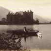
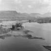
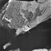
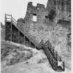
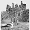
NN 132 276. The castle (plates. 69, 70, 71) stands upon a low peninsula at the NE extremity of Loch Awe, and commands an extensive prospect embracing the upper part of the loch, Glen Strae and the Strath of Orchy. The site itself (Fig.205) is a small rocky eminence surrounded by marshy ground, and further delimited on the landward side of the peninsula by an artificial ditch having a width of about 4' 5 m and a present depth of about 0·6 m. When the level of the loch is high the site is virtually insulated, and at least one early writer states that the castle stands upon an island (Pockocke, Tours, 68; but cf. Stoddart, Local Scenery, I, 269). Moreover, the remains of what appears to be a small jetty, or boat-landing, composed of boulders, can be seen on the SE side of the castle, It is known, however, that some clearance of the river bed at the outflow into the Pass of Brander was carried out in 1817, and this probably resulted in a general lowering of the level of the loch (PSAS, vii (1866-8), 235).
SYNOPSIS
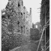
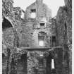
The castle (Figs. 205, 206) comprises a series of buildings ranging in date from about the middle of the 15th century to about the end of the 17th century. The earliest of these is a five-storeyed tower-house standing at the E corner of the castle, which is known to have been erected by Sir Colin Campbell, 1st of Glenorchy, who died in 1475. Immediately to the SW of the tower house there was probably a small courtyard or barmkin, enclosed by a curtain-wall of which considerable remains appear to survive on the S and SE sides. The main entrance to the courtyard lay through the ground floor of the tower-house, but there was also a postern in the S section of the curtain-wall. The courtyard probably contained a number of ancillary buildings.
The next building to come on record is the 'laich hall', which was constructed by Sir Duncan Campbell, 2nd of Glenorchy (1475-1513). Later documentary information suggests that this structure stood against the inner face of the S curtain, where the foundations of a substantial stone building lie just beneath the turf. Sir Colin Campbell, 6th of Glenorchy (1550-83), reconstructed the upper storey of the tower-house and added corbelled angle-rounds. He was also responsible for the erection of a building known as the 'north chalmeris', which presumably stood on the NW side of the courtyard, but of this no traces now remain. It is recorded that in 1614 the laich hall, together with a kitchen which seems to have occupied the S corner, of the courtyard, was rebuilt and raised to a height of two storeys, while two years later a range of buildings comprising two cellars, a loft and a chapel, was erected on the SE side of the courtyard. Further extensive repairs are known to have been made to the laich hall and tower-house in 1643. The last major phase of building-operations was carried out during the period c. 1690-98, when John, 1st Earl of Breadalbane, remodelled much of the castle, and enlarged it by the construction of cylindrical angle towers and of two ranges of four-storeyed barrack blocks situated on the NW side of the courtyard. The castle appears to have been abandoned as a residence about the middle of the 18th century and was unroofed in about 1770, after which the fabric deteriorated rapidly (NSA, vii (Argyll), 88; Pennant, Tour (1769), 237). Some time after MacGibbon and Ross made their survey of the castle in c. 1887 (Cast. And Dom. Arch., I, 382-4) the building appears to have been extensively patched and consolidated, an operation which unfortunately led to the obliteration or alteration of a number of original structural features.
See RCAHMS 1975 (pp. 231-240, No. 293, figs. 206-9, plates 69-75) for a full architectural description and historical note.
RCAHMS 1975, visited July 1969.
Measured Survey (1969)
RCAHMS undertook measured survey at Kilchurn Castle c.1969. The original pencil drawings were redrawn in ink and published at a reduced scale (RCAHMS 1975, figs. 205-9). The final published drawings included:
Fig. 205: general plan and lower ground-floor plan of NW and NE ranges
Fig. 206: first-floor plan and upper-floor plans of tower-house
Fig. 207: mason's marks
Fig. 208: profile mouldings
Fig. 209: gun-loops and pistol-holes
Aerial Photography (1971)
Oblique aerial photographs of Kilchurn Castle, Argyll, taken by John Dewar in 1971.
Publication Account (1985)
At the north-eastern end of Loch Awe the impressive ruin of Kilchurn Castle is situated on a small rocky outcrop almost surrounded by the waters of the loch. Loch Awe was clearly an important route in historical times, as probably in the prehistoric period, and there are several castles along it including Fincharn (NM 898043) and Innis Chonnell (NM 976119), but the strategic importance ofKilchurn to the Campbells of Glenorchy with estates both in Loch Awe and Perthshire was considerable. The surviving remains belong to two distinct schemes of construction: a tower-house built in the middle of the 15th century by Sir Colin Campbell of Glenorchy; and the addition of ranges of barracks within a defensive scheme that had corner towers built by John, 1st Earl of Breadalbane in the last decade of the 17th century.
The tower-house, now an empty shell, has five storeys, the lowest of which is a vaulted cellar, with what was doubtless a prison on its south-east side. The main apartment was the first-floor hall, probably entered from a doorway into the courtyard by means of a wooden stair; there is also a narrow stair from the cellar. The separate staircases to the upper floors are within the angles of the walls.
One of the most dramatic features of the castle as it survives today are the dominant circular angle towers on the north and south flanks; these are the main architectural embellishments of the late 17th century barrack ranges. The barracks played their part intermittently in the military politics of the next sixty years, but the castle was struck by lightning in the 1760s and was not subsequently refurbished. The energies of the Earl of Breadalbane were devoted to his castle and estates at Taymouth in Perthshire.
Information from ‘Exploring Scotland’s Heritage: Argyll and the Western Isles’, (1985).
Excavation (1 November 1992 - 20 November 1992)
A short programme of trial excavation was completed within the castle, in advance of new drainage within the basements of the two late 17th century barrack blocks. The causes of the present flooding were due initially to the 1690's ranges having been built outside, and consequently with basements below, the natural rocky outcrop which previously defined the fortified circuit. The measures put in places to collect and conduct storm water from the courtyard - a system of downpipes and probably a subfloor drainage channel - are now blocked and broken.
An apparently deliberate gap was left between bedrock and the basement passage wall, in order to trap water seeping beneath the courtyard facing of the barrack block. It is likely that this was linked in some way with the main drain outflow point in the basement beneath the latrines.
Some structural evidence was found of a building lying towards the NW of the 15th-century Towerhouse and which was demolished in advance of the 1690's building programme. It is possible that the section of much robbed walling referred to as the'North Chalmeris'.
Some indication of pre-15th century occupation of the site was found in terms of a mass of fire-reddened and vitrified masonry, some of it recycled as levelling material within the basement. It is therefore possible that some form of drystone rampart existed on the site which has been absorbed by the late 17th-century extensions to the castle on its N and W sides.
G Ewart 1993
Sponsor: Historic Scotland
Kirkdale Archaeology
Watching Brief (1 October 2008)
NN 1329 2760 A watching brief was maintained on 1 October 2008 in the basement of the tower house of the castle during the removal of soft deposits from the floor, ahead of the laying of a concrete skim. There was evidence suggesting that the N door was a later insertion and that the basement was originally accessed via another door, perhaps the SW doorway to the courtyard. Examination of the main build of the exterior NE wall of the tower provided further evidence for the later insertion of the N doorway. There was a clear cut around the inserted doorway and the masonry within it consisted of sub-rounded sandstone blocks spaced with
slivers of schist, which is comparable to the build of the late 17th-century barracks abutting the tower to the NW.
Archive: RCAHMS (intended)
Funder: Historic Scotland
Paul Fox – Kirkdale Archaeology
Information from OASIS ID: kirkdale1-249683
Desk Based Assessment (March 2014 - August 2014)
CFA Archaeology Ltd undertook and assessment of the effects on cultural heritage interests of the construction, operation and decommissioning of the Proposed Development, at Balliemeanoch, Argyll & Bute.
All historic environmental features within the development area were identified and the nature of effects on these features discussed.
Funder: Energised Environments Ltd
CFA Archaeology ltd
Field Visit (June 2017)
NN 13284 27615 In June 2017, a desk based assessment and survey were carried out, across the castle grounds and parts of the opposite shore at Portbeg.
Three drystone boulder walls were encountered within the areas of interest during the survey, along with one furrow likely to be a drainage ditch issuing into the loch.
Archive: NRHE
Funder: Historic Environment Scotland
Stephanie Said – Wessex Archaeology
(Source: DES Vol 20)
Desk Based Assessment (2 November 2017 - 3 November 2017)
Wessex Archaeology was commissioned by Historic Environment Scotland (HES) to undertake a desk based assessment and walkover survey to identify cultural heritage constraints in advance of some works to be carried out at Kilchurn Castle. The aim of this assessment is to identify known heritage assets that may be affected by the works to be carried out at Kilchurn Castle and the potential for unknown cultural heritage assets. This will be carried out in accordance with the Chartered Institute for Archaeologists’ Standard and Guidance for Desk-based Assessment (CIfA, 2014).
The Site Boundary consists of three areas; the area around Kilchurn Castle (Plot 2 - smaller Portbeg, and Plot 3 - larger Portbeg). Kilchurn Castle is located on a rocky peninsula, surrounded by marsh land, at the northeastern end of Loch Awe, in Argyll and Bute, Scotland. Portbeg is located along the southern shore of the loch opposite Kilchurn Castle.
Project (25 February 2018 - 1 March 2018)
NN 13287 27626 A programme of geophysical survey was undertaken. 25 February – 1 March 2018, within and around Kilchurn Castle. An area of 0.5 ha within the castle and over the peninsular to the W of the castle was surveyed. A combination of gradiometer, resistance and ground penetrating radar (GPR) surveys were undertaken. Survey to the E and N of the castle was not possible due to a combination of boggy and frozen ground.
Resistance survey within the courtyard of the castle detected numerous anomalies suggesting possible structural remains. Additional anomalies were detected, which may have an archaeological origin, but could equally be due to more modern features such as paths. GPR within the courtyard did not produce particularly clear responses and this is thought to be due to the combination of shallow remains and shallow bedrock, although there is some
correlation with the resistance survey data. Survey of the peninsula to the W of the castle did not identify any anomalies of a clearly archaeological origin. The gradiometer data is dominated by responses from modern debris, while the resistance data appears to be dominated by natural variations associated with shallow bedrock and changes in the loch shoreline.
Archive: Rose Geophysical Consultants
Funder: CFA Archaeology on behalf of HES
Susan Ovenden - Rose Geophysics
(Source: DES, Volume 19)
Ground Penetrating Radar (25 February 2018 - 1 March 2018)
NN 13287 27626 Ground penetrating radar survey.
Archive: Rose Geophysical Consultants
Funder: CFA Archaeology on behalf of HES
Susan Ovenden - Rose Geophysics
(Source: DES, Volume 19)
Magnetometry (25 February 2018 - 1 March 2018)
NN 13287 27626 Magnetometry survey.
Archive: Rose Geophysical Consultants
Funder: CFA Archaeology on behalf of HES
Susan Ovenden - Rose Geophysics
(Source: DES, Volume 19)
Earth Resistance Survey (25 February 2018 - 1 March 2018)
NN 13287 27626 Resistivity survey.
Archive: Rose Geophysical Consultants
Funder: CFA Archaeology on behalf of HES
Susan Ovenden - Rose Geophysics
(Source: DES, Volume 19)
Project (25 February 2018 - 1 March 2018)
NN 13287 27626 A programme of geophysical survey was undertaken. 25 February – 1 March 2018, within and around Kilchurn Castle. An area of 0.5 ha within the castle and over the peninsular to the W of the castle was surveyed. A combination of gradiometer, resistance and ground penetrating radar (GPR) surveys were undertaken. Survey to the E and N of the castle was not possible due to a combination of boggy and frozen ground.
Resistance survey within the courtyard of the castle detected numerous anomalies suggesting possible structural remains. Additional anomalies were detected, which may have an archaeological origin, but could equally be due to more modern features such as paths. GPR within the courtyard did not produce particularly clear responses and this is thought to be due to the combination of shallow remains and shallow bedrock, although there is some
correlation with the resistance survey data. Survey of the peninsula to the W of the castle did not identify any anomalies of a clearly archaeological origin. The gradiometer data is dominated by responses from modern debris, while the resistance data appears to be dominated by natural variations associated with shallow bedrock and changes in the loch shoreline.
Archive: Rose Geophysical Consultants
Funder: CFA Archaeology on behalf of HES
Susan Ovenden - Rose Geophysics
(Source: DES, Volume 19)
Field Visit (February 2018 - March 2018)
NN 13287 27626 A walkover assessment was undertaken,
February – March 2018, complemented by historic map
and documentary research, of selected areas of the wooded
landscape around Kilchurn Castle (PIC080), originally a
property of the Earls of Breadalbane. The objective was to
enhance the understanding of the properties relationship
with the diverse wooded landscape around the N end of Loch
Awe, including both economic and aesthetic aspects.
Four distinct areas were assessed: Kilchurn Castle and its
peninsula; Portbeg and the oak woodlands at Kinachreachan;
Ardteatle historic township and environs; and The Pass of
Brander oakwoods.
The wood on the castle peninsula is a semi-natural wet
wood, dominated by willow, with the grown-out remnants of
a hedge on its E side. Loch water levels are lower now than
in the past, and the castle knoll would have been an island
when it was in use. To the E of the castle at Portbeg, on the
E loch shore, historically the castle’s mains farm, there are
several historic plantations with enclosing dykes, including
an attractive loch-side beech knoll of probable 18th-century
origin, and a number of old oak plantations. The latter are
not on Roy’s mid-18th-century map, but are on the 1st Edition
OS 6" map, and therefore originate in the late 18th or early
19th century. LiDAR survey by HES assisted in tracing the
plantation dykes and other archaeological features in areas
where they were hidden within dense modern conifer stands.
The Ardteatle area, further S on the E shore, has many
interesting veteran trees around the ruined settlement
remains, to the E of the Old Military Road, including an
ancient gean probably planted on the yard dyke of a now
ruinous cottage. Nearby, just W of that old road, is a quite
different enclosure in which massive old open-grown oaks,
recently made visible by the felling of the modern conifers
planted into them, indicate the possible location of the Earl’s
17th-century park, mentioned in the estate records as being
established at Ardteatle then. Many of the oaks have massive
fused multiple stems, indicative of graze-damaged coppice
and are an important biocultural survival.
On the W side of the loch, close to the castle, there are
extensive relict wood pastures, including a particularly diverse
one on the steep slopes at Creag a’ Chuil, where the ancient
trees are interspersed with traces of settlement and possible
charcoaling platforms. Among the tree types present are treeform
hazels, like the famous examples at Glen Finglas. A little
further S, at Coille Leitire, above the railway line, there is
extensive old oak coppice, with many more better-preserved
charcoal platforms. These woods would have fed fuel to
Bonawe and the other iron furnaces in the area in the 18th and
19th centuries. The HWA evidence highlights the continued use
and development of the estate’s wooded landscape elements
after the occupation of the castle ceases in the mid-18th century.
Archive: NRHE (intended). Report: Angus HER
Funder: Historic Environment Scotland
Coralie Mills and Peter Quelch – Dendrochronicle for CFA
Archaeology Ltd
(Source: DES, Volume 19)

