
Falkirk, Camelon Road, Rosebank Distillery


Distillery (19th Century)
Site Name Falkirk, Camelon Road, Rosebank Distillery
Classification Distillery (19th Century)
Canmore ID 83240
Site Number NS88SE 111
NGR NS 87625 80289
NGR Description Centred NS 87625 80289
Datum OSGB36 - NGR
Permalink http://canmore.org.uk/site/83240
Ordnance Survey licence number AC0000807262. All rights reserved.
Canmore Disclaimer.
© Bluesky International Limited 2025. Public Sector Viewing Terms
- Correction
- Favourite

SC 572881
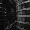
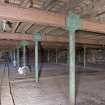
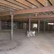
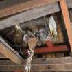
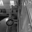
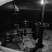
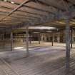
Falkirk, Rosebank Distillery; Interior View of washbacks
Papers of Professor John R Hume, economic and industrial historian, Glasgow, Scotland
1980
© Copyright: HES (Reproduced courtesy of J R Hume)

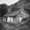
SC 676227
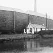
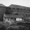
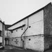
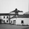
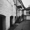
View from NNE showing ENE front and part of NNW front of cottage with distillery in background
Papers of Professor John R Hume, economic and industrial historian, Glasgow, Scotland
22/4/1966
© Copyright: HES (Reproduced courtesy of J R Hume)

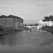
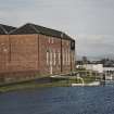
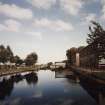
SC 691360
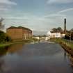
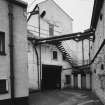
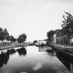
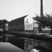
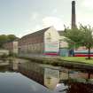
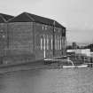
View of distillery and warehouses from canal bridge to south west
18/2/2002
© Crown Copyright: HES

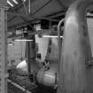
SC 742441
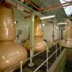
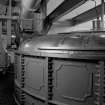
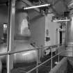
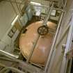
Still Room: view of 3 (steam-heated) stills (L to R): No 1 Low Wines Still, 9587 litres; Wash Still; No 2 Low Wines Still, 7628 litres, all R & G Abercrombie of Alloa, dated 1962. Rosebank is one of only 2 triple-distilled whiskies in Scotland Digital image of C 19607 CN
1993
© Crown Copyright: HES

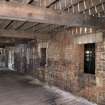
DP 057436
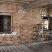
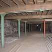
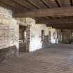
Interior view, ground floor of bonded warehouse (east section) at former Rosebank Distillery
Records of the Royal Commission on the Ancient and Historical Monuments of Scotland (RCAHMS), Edinbu
3/4/2009
© Crown Copyright: HES

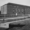
DP 057451
View from NW
Records of the Royal Commission on the Ancient and Historical Monuments of Scotland (RCAHMS), Edinbu
3/4/2009
© Crown Copyright: HES

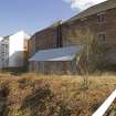
SC 2493644
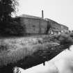
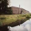
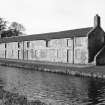
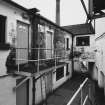
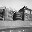
View of canal-side out-building from West with Rosebank Distillery in background.
9/1993
© RCAHMS

SC 2493740
View of distillery and warehouses from canal bridge to south west
Records of the Royal Commission on the Ancient and Historical Monuments of Scotland (RCAHMS), Edinbu
18/2/2002
© Crown Copyright: HES

SC 2493748
View of distillery from canal bridge to south west
Records of the Royal Commission on the Ancient and Historical Monuments of Scotland (RCAHMS), Edinbu
18/2/2002
© Crown Copyright: HES


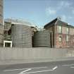
SC 2494085
View of duty free warehouse no 1 from across central yard from SE.
1/11/1993
© RCAHMS

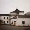
SC 676225
View from NE showing ENE front of lock with depot, cottage and distillery in background
Papers of Professor John R Hume, economic and industrial historian, Glasgow, Scotland
22/4/1966
© Copyright: HES (Reproduced courtesy of J R Hume)

DP 057443
Interior view, view across first floor of bonded warehouse (east section) at former Rosebank Distillery
Records of the Royal Commission on the Ancient and Historical Monuments of Scotland (RCAHMS), Edinbu
3/4/2009
© Crown Copyright: HES

DP 057452
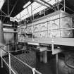
Interior. View of former still house
Records of the Royal Commission on the Ancient and Historical Monuments of Scotland (RCAHMS), Edinbu
3/4/2009
© Crown Copyright: HES


SC 2493643
View of canal-side out-building from NW with Rosebank Distillery in background.
9/1993
© RCAHMS

SC 2493747
View of distillery from canal bridge to south west
Records of the Royal Commission on the Ancient and Historical Monuments of Scotland (RCAHMS), Edinbu
18/2/2002
© Crown Copyright: HES


SC 2494067
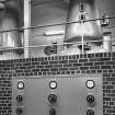
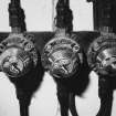
Interior. View of still room. View of still control panel, with L to R No 1 low wines still, 9587 litres, and wash still.
9/1993
© RCAHMS

SC 2494068
Interior. View of still house. View of spirit safe, positioned on top of intermediate spirit receiver.
9/1993
© RCAHMS

SC 2494072
Interior. View of mill house showing malt-dressing machinery manufactured by Porteus of Leeds.
9/1993
© RCAHMS


SC 2494093
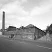
View from NE of corner of distillery block, containing mill house, and duty free warehouse no 5.
1/11/1993
© RCAHMS

SC 2494094
View from W across yard, showing duty free warehouse no 1, including store and workshop, and still house, right.
1/11/1993
© RCAHMS

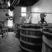
SC 572878
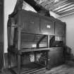
Falkirk, Rosebank Distillery; Interior View of mash tuns
Papers of Professor John R Hume, economic and industrial historian, Glasgow, Scotland
1980
© Copyright: HES (Reproduced courtesy of J R Hume)

SC 572885
Falkirk, Rosebank Distillery, Stillhouse; Interior General View
Papers of Professor John R Hume, economic and industrial historian, Glasgow, Scotland
1980
© Copyright: HES (Reproduced courtesy of J R Hume)

SC 572887
Falkirk, Rosebank Distillery, Stillhouse; Interior View of spirit safe and receiver
Papers of Professor John R Hume, economic and industrial historian, Glasgow, Scotland
1980
© Copyright: HES (Reproduced courtesy of J R Hume)

DP 057437
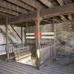
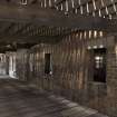
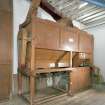
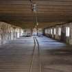
Interior view, bonded warehouse at former Rosebank Distillery. Detail of barrel runners, barrel table and barrel catch
Records of the Royal Commission on the Ancient and Historical Monuments of Scotland (RCAHMS), Edinbu
3/4/2009
© Crown Copyright: HES

DP 057446
Interior view of the bonded warehouse at the former Rosebank Distillery. Detail of barrel hoist motor in the roof space of the second floor
Records of the Royal Commission on the Ancient and Historical Monuments of Scotland (RCAHMS), Edinbu
3/4/2009
© Crown Copyright: HES

SC 2493742
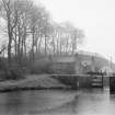
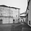
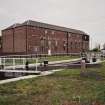
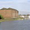
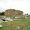
View of warehouses and canal lock gates from south
Records of the Royal Commission on the Ancient and Historical Monuments of Scotland (RCAHMS), Edinbu
18/2/2002
© Crown Copyright: HES

SC 2493743
View of warehouses from south
Records of the Royal Commission on the Ancient and Historical Monuments of Scotland (RCAHMS), Edinbu
18/2/2002
© Crown Copyright: HES

SC 2493744
View of warehouses from south
Records of the Royal Commission on the Ancient and Historical Monuments of Scotland (RCAHMS), Edinbu
18/2/2002
© Crown Copyright: HES

SC 2493745
View of warehouses and lock gates from south
Records of the Royal Commission on the Ancient and Historical Monuments of Scotland (RCAHMS), Edinbu
18/2/2002
© Crown Copyright: HES

SC 2493746
View of warehouses and lock gates from south
Records of the Royal Commission on the Ancient and Historical Monuments of Scotland (RCAHMS), Edinbu
18/2/2002
© Crown Copyright: HES


SC 572852
Falkirk, Rosebank Distillery; Interior View of mash tun
Papers of Professor John R Hume, economic and industrial historian, Glasgow, Scotland
1980
© Copyright: HES (Reproduced courtesy of J R Hume)

SC 572882
Falkirk, Rosebank Distillery, Stillhouse; Interior General View
Papers of Professor John R Hume, economic and industrial historian, Glasgow, Scotland
1980
© Copyright: HES (Reproduced courtesy of J R Hume)

SC 572884
Falkirk, Rosebank Distillery, Stillhouse; Interior General View
Papers of Professor John R Hume, economic and industrial historian, Glasgow, Scotland
1980
© Copyright: HES (Reproduced courtesy of J R Hume)

DP 057438
Interior view, bonded warehouse at former Rosebank Distillery. Hatch for barrel hoist at first floor
Records of the Royal Commission on the Ancient and Historical Monuments of Scotland (RCAHMS), Edinbu
3/4/2009
© Crown Copyright: HES

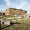
DP 057454
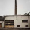
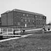
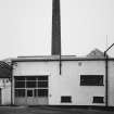
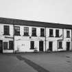
View from SE
Records of the Royal Commission on the Ancient and Historical Monuments of Scotland (RCAHMS), Edinbu
3/4/2009
© Crown Copyright: HES

SC 1389993
View of warehouses and canal lock gates from south
Records of the Royal Commission on the Ancient and Historical Monuments of Scotland (RCAHMS), Edinbu
18/2/2002
© Crown Copyright: HES

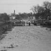
SC 1935850
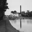
View of distillery from canal towpath to west
Records of the Royal Commission on the Ancient and Historical Monuments of Scotland (RCAHMS), Edinbu
14/10/2001
© Crown Copyright: HES

SC 2493738
View of distillery from canal towpath to west
Records of the Royal Commission on the Ancient and Historical Monuments of Scotland (RCAHMS), Edinbu
14/10/2001
© Crown Copyright: HES

SC 2494066
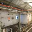
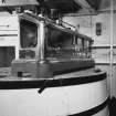
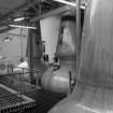
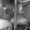
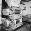
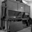
Interior. View of still room. View of wash receiver charger, a tank assembled from cast-iron panels, and built by R. & G. Abercrombie of Alloa. No 2 low wines still is to left.
9/1993
© RCAHMS


SC 572883
Falkirk, Rosebank Distillery, Stillhouse; Interior General View
Papers of Professor John R Hume, economic and industrial historian, Glasgow, Scotland
1980
© Copyright: HES (Reproduced courtesy of J R Hume)

SC 572886
Falkirk, Rosebank Distillery, Stillhouse; Interior General View
Papers of Professor John R Hume, economic and industrial historian, Glasgow, Scotland
1980
© Copyright: HES (Reproduced courtesy of J R Hume)

SC 572888
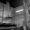
Falkirk, Rosebank Distillery; Interior View of boiler
Papers of Professor John R Hume, economic and industrial historian, Glasgow, Scotland
1980
© Copyright: HES (Reproduced courtesy of J R Hume)

DP 057442
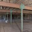
Interior view, looking along the S side of the dividing wall within the first floor of bonded warehouse (west section) at the former Rosebank Distillery.
Records of the Royal Commission on the Ancient and Historical Monuments of Scotland (RCAHMS), Edinbu
3/4/2009
© Crown Copyright: HES

SC 1389995
View of warehouses and lock gates from south
Records of the Royal Commission on the Ancient and Historical Monuments of Scotland (RCAHMS), Edinbu
18/2/2002
© Crown Copyright: HES


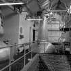
SC 2494071
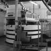
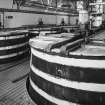
Interior. View of mash house looking down onto copper-topped mash tun.
9/1993
© RCAHMS

SC 2494073
Interior. View of mill house. View of Boby malt mill, dating from the 1930s. Note that the sides have been removed, revealing the rolls.
9/1993
© RCAHMS


SC 572880
Falkirk, Rosebank Distillery; Interior View of yeast hoist and washbacks
Papers of Professor John R Hume, economic and industrial historian, Glasgow, Scotland
1980
© Copyright: HES (Reproduced courtesy of J R Hume)

SC 742444
Mash House: view looking down onto copper-topped Mash Tun
1993
© Crown Copyright: HES

SC 742448
Mill House: view of malt-dressing machinery, manufactured by Porteus of Leeds Digital image of C 19617 CN
1993
© Crown Copyright: HES

DP 057444
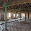
Interior view of bonded warehouse (west section) at former Rosebank Distillery. Detail of window apertures on N side of the dividing wall at first floor.
Records of the Royal Commission on the Ancient and Historical Monuments of Scotland (RCAHMS), Edinbu
3/4/2009
© Crown Copyright: HES

DP 057447
Interior view of bonded warehouse (west section) at rosebank Distillery. View looking along the barrel runners in the N side of the warehouse towards the barrel hoist.
Records of the Royal Commission on the Ancient and Historical Monuments of Scotland (RCAHMS), Edinbu
3/4/2009
© Crown Copyright: HES

SC 2494074
Interior. Detail of flame-proof light switches in still house.
9/1993
© RCAHMS


SC 2494086
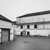
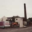
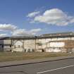
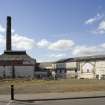
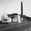
View across central yard from N, showing offices, left, and main distillery production buildings, centre.
1993
© RCAHMS

SC 2494087
View across central yard from N, showing offices, left, and main distillery production buildings, centre.
1/11/1993
© RCAHMS

SC 572850
Falkirk, Rosebank Distillery; Interior View of malt mill
Papers of Professor John R Hume, economic and industrial historian, Glasgow, Scotland
1980
© Copyright: HES (Reproduced courtesy of J R Hume)

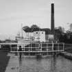
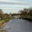
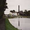
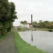
SC 700202
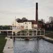
General view of canal, series of locks and distillery from bridge to south west
18/2/2002
© RCAHMS

SC 742451
General view of Rosebank Distillery, Falkirk, across Forth Clyde Canal basin from W.
1993
© Crown Copyright: HES

DP 057434
Interior view, ground floor of bonded warehouse (west section) at former Rosebank Distillery
Records of the Royal Commission on the Ancient and Historical Monuments of Scotland (RCAHMS), Edinbu
3/4/2009
© Crown Copyright: HES

DP 057435
Interior view, ground floor of bonded warehouse (east section) (west section) at former Rosebank Distillery
Records of the Royal Commission on the Ancient and Historical Monuments of Scotland (RCAHMS), Edinbu
3/4/2009
© Crown Copyright: HES

DP 057439
Interior view, first floor of bonded warehouse (west section) at former Rosebank Distillery
Records of the Royal Commission on the Ancient and Historical Monuments of Scotland (RCAHMS), Edinbu
3/4/2009
© Crown Copyright: HES

DP 057440
Interior view, first floor of bonded warehouse (west section) at former Rosebank Distillery.
Records of the Royal Commission on the Ancient and Historical Monuments of Scotland (RCAHMS), Edinbu
3/4/2009
© Crown Copyright: HES

DP 057445
Interior view of the bonded warehouse (west section) at former Rosebank Distillery, looking along the N side of the dividing wall at first floor, towards the barrel hoist.
Records of the Royal Commission on the Ancient and Historical Monuments of Scotland (RCAHMS), Edinbu
3/4/2009
© Crown Copyright: HES

DP 057450
Detail of blocked slits on N wall
Records of the Royal Commission on the Ancient and Historical Monuments of Scotland (RCAHMS), Edinbu
3/4/2009
© Crown Copyright: HES

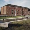
DP 057453
View from E
Records of the Royal Commission on the Ancient and Historical Monuments of Scotland (RCAHMS), Edinbu
3/4/2009
© Crown Copyright: HES

SC 2493739
View of distillery from canal towpath to west
Records of the Royal Commission on the Ancient and Historical Monuments of Scotland (RCAHMS), Edinbu
14/10/2001
© Crown Copyright: HES

SC 2493749
General view of canal, series of locks and distillery from bridge to south west
Records of the Royal Commission on the Ancient and Historical Monuments of Scotland (RCAHMS), Edinbu
18/2/2002
© Crown Copyright: HES

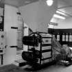
SC 2494064
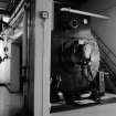
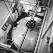
Interior. View of still room. View of three steam-heated stills, L to R: No 1 low wines still, 9587 litres; wash still; No 2 low wines still, 7628 litres, all R. & G. Abercrombie of Alloa, dated 1962. Rosebank is one of only two triple-distilled whiskies in Scotland.
9/1993
© RCAHMS

SC 2494065
Interior. View of still room. View of three stills, showing wash still in centre, built by R. & G. Abercrombie of Alloa in 1962, and designed with a flat top.
9/1993
© RCAHMS


SC 572848
Falkirk, Rosebank Distillery; Interior View of weighing machine
Papers of Professor John R Hume, economic and industrial historian, Glasgow, Scotland
1980
© Copyright: HES (Reproduced courtesy of J R Hume)

SC 572849
Falkirk, Rosebank Distillery; Interior View of malt cleaner
Papers of Professor John R Hume, economic and industrial historian, Glasgow, Scotland
1980
© Copyright: HES (Reproduced courtesy of J R Hume)

SC 572853
Falkirk, Rosebank Distillery; Interior View of mash tun
Papers of Professor John R Hume, economic and industrial historian, Glasgow, Scotland
1980
© Copyright: HES (Reproduced courtesy of J R Hume)

SC 572879
Falkirk, Rosebank Distillery; Interior View of washbacks
Papers of Professor John R Hume, economic and industrial historian, Glasgow, Scotland
1980
© Copyright: HES (Reproduced courtesy of J R Hume)


DP 057441
Interior view, looking along the S side of the dividing wall within the first floor of bonded warehouse (west section) at the former Rosebank Distillery.
Records of the Royal Commission on the Ancient and Historical Monuments of Scotland (RCAHMS), Edinbu
3/4/2009
© Crown Copyright: HES

DP 057448
Interior view of second floor of bonded warehouse (east section) at the former Rosebank Distillery.
Records of the Royal Commission on the Ancient and Historical Monuments of Scotland (RCAHMS), Edinbu
3/4/2009
© Crown Copyright: HES

DP 057449
Interior view of second floor of bonded warehouse (east section) at former Rosebank Distillery.
Records of the Royal Commission on the Ancient and Historical Monuments of Scotland (RCAHMS), Edinbu
3/4/2009
© Crown Copyright: HES

SC 1389992
View of distillery from canal towpath to west
Records of the Royal Commission on the Ancient and Historical Monuments of Scotland (RCAHMS), Edinbu
14/10/2001
© Crown Copyright: HES

SC 1389994
View of warehouses from south
Records of the Royal Commission on the Ancient and Historical Monuments of Scotland (RCAHMS), Edinbu
18/2/2002
© Crown Copyright: HES

SC 2493741
View of warehouses and canal lock gates from south
Records of the Royal Commission on the Ancient and Historical Monuments of Scotland (RCAHMS), Edinbu
18/2/2002
© Crown Copyright: HES

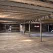
SC 2494069
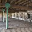
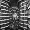
Interior. View of lower tun room showing lower portions of the eight wooden washbacks.
9/1993
© RCAHMS

SC 2494070
Interior. View of upper tun room showing tops of the eight wooden washbacks.
9/1993
© RCAHMS


- Council Falkirk
- Parish Falkirk
- Former Region Central
- Former District Falkirk
- Former County Stirlingshire
NS88SE 111.00 centred 87625 80289
NS88SE 111.01 NS 87518 80277 Bonded Warehouse
NS88SE 111.02 Centred NS 87526 80361 Maltings
NS88SE 111.03 Centred NS 87649 80322 Bonded Warehouses
NS 876 803 An excavation and standing building survey were undertaken in April 2005 in advance of a housing development on the site of the former Tophill Boatyard. The standing building and archaeological evidence showed that the remains were in accord with cartographic evidence. The graving dock was shown to have stone-lined stepped sides.
The remains of buildings comprising a carpenter's shop and a smithy, which contained the remains of three furnaces, were excavated. A 2m deep linear stone-built pit was excavated and shown to be most likely a sawpit. The remains of a boatshed with internal structures including machine plinths, anchors, brick surfaces and a slipway were also excavated.
Archive to be deposited in NMRS.
Sponsor: Westpoint Homes Ltd.
S Mitchell 2005.

