
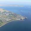
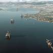
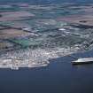
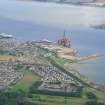
Invergordon, Royal Naval Dockyard, East Pier


Pier (First World War), Pier (20th Century), Pier (Second World War)
Site Name Invergordon, Royal Naval Dockyard, East Pier
Classification Pier (First World War), Pier (20th Century), Pier (Second World War)
Alternative Name(s) Cromarty Firth; Firth Of Cromarty; Admiralty Pier
Canmore ID 300396
Site Number NH76NW 64.01
NGR NH 71155 68367
NGR Description NH 71113 68484 to NH 71192 68270
Datum OSGB36 - NGR
Permalink http://canmore.org.uk/site/300396


- Council Highland
- Parish Rosskeen
- Former Region Highland
- Former District Ross And Cromarty
- Former County Ross And Cromarty
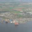
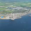
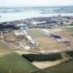
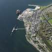
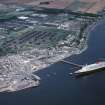
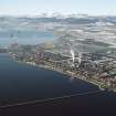
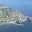
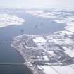
The east pier or Admiralty Pier is marked on a map of the naval base (held in a private collection) during the First World War and was the deepwater pier. The pier strikes out SSE for about 230m, with two eastward and one westward extension, most of which were served by railway lines.
The pier also carried pipes for oil and water.
Information from HS/RCAHMS World War One Audit Project (GJB) 1 August 2013.
Project (March 2013 - September 2013)
A project to characterise the quantity and quality of the Scottish resource of known surviving remains of the First World War. Carried out in partnership between Historic Scotland and RCAHMS.
Note (26 August 2015)
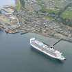
The pier which was constructed from wooden piles was replaced in the early 1950's by the existing concrete piles. The disused narrow NW jetty is still of wooden construction and may been a remaining section of the original pier dating back to the First World War.
Information from RCAHMS (AKK) 26 August 2015.

