
Carnassarie Castle


Gateway (17th Century), Outbuilding(S) (Post Medieval), Tower House (Medieval)
Site Name Carnassarie Castle
Classification Gateway (17th Century), Outbuilding(S) (Post Medieval), Tower House (Medieval)
Alternative Name(s) Carnasserie Castle, Carnassery Castle
Canmore ID 22835
Site Number NM80SW 2
NGR NM 83908 00848
Datum OSGB36 - NGR
Permalink http://canmore.org.uk/site/22835


First 100 images shown. See the Collections panel (below) for a link to all digital images.
- Council Argyll And Bute
- Parish Kilmartin
- Former Region Strathclyde
- Former District Argyll And Bute
- Former County Argyll
NM80SW 2 83908 00848.
(NM 8390 0086) Carnasserie Castle (NR) (In Ruins)
OS 6" map, Argyllshire, 2nd ed., (1900)
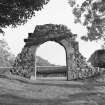
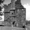
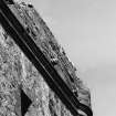
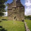
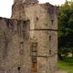
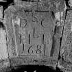
Carnasserie Castle, though apparently an early square keep with a hall-house attached to the W was in fact built all at the one time, in the 1560s by John Carswell, first protestant Bishop of the Isles, on the site of an older castle. The 5' - 6' thick walls of the roofless keep, provided with small gun-ports, rise 5 storeys high, with the wing one storey lower. A courtyard extended to the W and S, the walls and outbuildings of which have almost entirely disappeared, only a small portion of the wall next the SW angle of the house, and a gateway, dated 1681, remaining.
N Tranter 1962-70; D MacGibbon and T Ross 1887-92; DoE TS, undated
The remains of Carnasserie Castle are generally as described. Name confirmed.
Visited by OS (RD) 12 October 1971.
NM 8390 0084 Excavations were undertaken in January 1998. The castle is a late 16th-century tower house with contemporary wing, situated above the main road from Oban to Lochgilphead, and was built by John Carsewell, first Protestant Bishop of the Isles.
The excavations were designed to allow drainage work to be carried out in the first-floor chamber at the E end of the castle. Two small trenches were excavated by hand at the N end of this room, in order to characterise the deposits therein, which appeared to be contemporary with the building of the castle. A small trench was excavated outside the castle, against the wall, at the base of a latrine shaft leading from an alcove off the first-floor chamber. The trench contained the construction trench for the castle wall or the cut for a drain.
Sponsor: Historic Scotland
D Murray 1998
NM 839 008 Site included in a field survey carried out by GUARD in 2003.
H F James, 2003 (RCAHMS MS 2371, no. 22)
This site has only been partially upgraded for SCRAN. For full details, please consult the Architecture Catalogues for Argyll and Bute District.
March 1998
Measured Survey (June 1981)
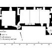
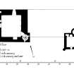
RCAHMS surveyed Carnassarie Castle in June 1981 producing plans of parapet, entresol, ground, first, second and third floors at a scale of 1:100. The plans were redrawn in ink and published at a scale of 1:250 (RCAHMS 1992, 216).
Measured Survey (9 August 1982)
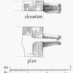
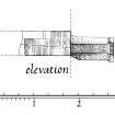
RCAHMS surveyed Carnassarie Castle between 9 August 1982 producing an elevation and plan of the doorway in the NE angle of the main hall on the first floor at a scale of 1:20. The elevation and plan were redrawn in ink and published at a scale of 1:50 (RCAHMS 1992, 223).
Measured Survey (8 June 1982 - 9 June 1982)
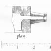
RCAHMS surveyed Carnassarie Castle between 8-9 June 1982 producing an elevation and a plan of the fireplace in the north wall of the chamber, east tower at a scale of 1:20. The elevation and plan were redrawn in ink and published at a scale of 1:50 (RCAHMS 1992, 222A).
Measured Survey (11 May 1982)
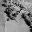
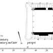
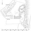
RCAHMS surveyed Carnassarie Castle on 11 May 1982 with plane-table and alidade producing a site plan at a scale of 1:400. The plan was redrawn in ink and published at a scale of 1:1000 (RCAHMS 1992, 225A).
Measured Survey (1982)
RCAHMS surveyed Carnassarie Castle in 1982 producing an elevation of the entrance-doorway at a scale of 1:20. The elevation was redrawn in ink and published at a scale of 1:50 (RCAHMS 1992, 218A).
Publication Account (1985)
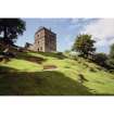
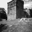
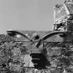
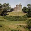
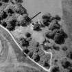
This impressive tower-house rises from a ridge that dominates the upper part of the Kilmartin Valley. The tower was built on the site of an earlier castle, and there may even be the remains of a small dun on the now grass-covered knoll immediately to the north-east. One of the latest of the tower-houses, it was built by a famous churchman John Carswelli he was superintendent of Argyll and the Isles in the Reformed Church from 1562 and was granted the bishopric of the Isles in 1567. Carswell was an influential figure in spreading the ideals of the Reformed religion in Argyll in the middle of the 16th century, and he published a Gaelic translation of the Book of Common Order or Knox's Liturgy in 1567i the first book to be printed in Gaelic, it contained the doctrines of the Presbyterian faith. The castle was built in the later 1560s under the patronage of the Earl of Argyll. The main hall was in the western wing of the castle, above the kitchen and storerooms, and the withdrawing room was on the same level on the first floor of the tower. This en suite arrangement is of some importance as it is thought to be transitional between castles and later mansionhouses, with the various rooms laid out in a horizontal rather than a vertical manner as in a traditional towerhouse. The main part of the tower is on five storeys with basal cellaragei the first-floor withdrawing room has a magnificent fireplace with finely carved surround and similar crisp detail round the doorways. The upper floors do not survive, but it is worth climbing to the upper parapet because there is a superb view down the valley. Only the shell of the western portion of the castle survives, but attractive outer string-mouldings still remain, as well as a rich provision of gun-loops and shot-holes.
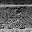
The inscribed panel above the doorway reads in Gaelic Dia le ua nduibhne translated as 'God be with o Duibhne'; O Duibhne is one of the styles of the chief of the Campbells, though one that was not current in the 1560s, and its use here suggests a conscious antiquarianism on Carswell's part. The heraldic panel is a combination of those of Campbell of Argyll and the royal arms of Scotland, probably indicating the marriage of Archibald 5th Earl of Argyll and Jean, a daughter of James V; the panel thus underlines Carswell's allegiance to the earl.
Information from ‘Exploring Scotland’s Heritage: Argyll and the Western Isles’, (1985).
Field Visit (September 1988)
The roofless but well-preserved ruin of this castle surmounts a ridge 80m above and 350m W of the Kilmartin Burn, almost opposite the junction of the head of the Kilmartin valley with the narrow pass leading SSW from Loch Ederline and Loch Awe. The castle comprises a tower-and-hall range of integral design incorporating much fine moulded detail. It was built between 1565 and 1572 by John Carswell, Bishop of the Isles and a close associate of Archibald Campbell, 5th Earl of Argyll, and was partly remodelled in the late 17th century. Wall-footings and stony debris on the rocky knoll a few metres NE of the tower may represent the remains of a medieval dwelling on the site [NM80SW 31], traces of earlier walling possibly extending down the intervening ridge and being incorporated within the fabric of the NE angle of the tower itself.
The walls of the castle are built of lime-mortared random rubble comprising split boulders and slabs of local metamorphic rock. Some external wall-surfaces retain traces of harling but there has been much careful repointing in modern times. The freestone dressings are of a green chlorite schist, usually either stugged or plain with drafted margins. The surviving masonry details are generally well-preserved and of excellent quality, and much of this early Scottish Renaissance decoration bears close comparison with near contemporary work at Torwood Castle, Stirlingshire (en.1).
Like Torwood, Carnassarie is substantially homogeneous in design, although there are indications of earlier work in the lower part of the N wall of the tower and later alterations of a minor nature have been effected throughout, the principal modification being the remodelling of the fenestration of the S frontage in the later 17th century. This work involved converting one of the first-floor hall windows into a doorway which, presumably by means of a timber forestair, gave on to a walled enclosure or garden with an outer arched gateway dated 1681. The ruin was placed in the guardianship of the then Office of Works by the Poltalloch estate in 1932, and a full programme of consolidation has been carried out by the Historic Buildings and Monuments Directorate in recent years.
RCAHMS 1992, visited September 1988
[A full architectural description and historical note is provided in RCAHMS 1992, 214-226)
Measured Survey (September 1988)
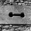
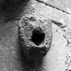
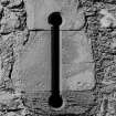
RCAHMS surveyed Carnassarie Castle in September 1988 producing interior and exterior elevations, sections and plans of the south wall pistol loop, re-entrant of east tower gun-port, south wall of east tower gun-port, north wall gun-port and east wall of tower gun-port at a scale of 1:20. These were redrawn in ink and published at a scale of 1:50 (RCAHMS 1992, 219B-C, E-G).
Excavation (14 January 1998 - 16 January 1998)
Kirkdale Archaeology were asked to undertake two small excavations at Carnasserie castle to assist Historic Scotland in remedial work at this site. The castle is a late sixteenth-century tower house with contemporary wing, situated above the main road from Oban to Lochgilphead built by John Carsewell, first protestant bishop of the Isles.
The excavations were designed to allow drainage work to be carried out in the first floor chamber at the E end of the castle. Two small trenches were excavated by hand at the N end of this room, in order to characterise the deposits therein. A small trench was excavated outside the castle, against the wall, at the base of a latrine shaft that leads from an alcove off the first floor chamber.
Sponsor: Historic Scotland
D Murray 1998
Kirkdale Archaeology
Watching Brief (11 May 1998)
Kirkdale Archaeology maintained a watching brief during the excavation of a track for a drain running from the base of the latrine shaft on the S side of this sixteenth century tower house (NM 839 008), on the 11/5/98. This led to a soakaway which was excavated by the hedge at the Southern limit of the site, a total distance of some 15 m. The drain itself averaged 30 cm wide, and was 25-30 cm deep, while the soakaway was 110 cm E-W, by 80 cm N-S, and 40 cm deep.
All excavated deposits appeared to be disturbed, with fragments of ceramic drainpipe being noted throughout, and a plastic water pipe was encountered running across the trench, evidently heading for the SE corner of the castle. The whole trench was dug through a fine, light brown silt, with much stone (mostly schist/slate, with some larger rounded stones) throughout. Stonier patches were noted, but no structure could be seen to these. No finds were retained
Kirkdale Archaeology, 1998
Watching Brief (19 March 2014)
A watching brief was maintained during the removal of an old information board and the installation of a new one. The site of the present sign lay within an eroded, crudely walled enclosure on the summit of a natural,
rocky, grass covered area of high ground to the SE of the castle. The hole left after removal of the sign footing plates measured 1m x 0.6m (N/S x E/W) and was up to 0.15m deep. The work necessitated the
removal of only turf and topsoil. There were no finds or features of archaeological significance.
Information from Gordon Ewart (Kirkdale Archaeology) May 2014.
OASIS ID: kirkdale1-196089
Project (1 March 2017 - 5 March 2017)
NM 83908 00848 (NM80SW 2) A programme of geophysical survey was undertaken, 1–5 March 2017, over available areas of Carnasserie Castle. This tower-house was built by John Carswell. As the bishop of the Isles, he was an influential figure in spreading the ideals of the Reformed religion in
Argyll in the middle of the 16th century, and published a Gaelic translation of the Book of Common Order or Knox’s Liturgy in 1567, the first book to be printed in Gaelic. The tower was built on the site of an earlier castle, and there may be the remains of a small dun on the grassy knoll immediately to the NE of the tower-house.
The survey area lies within the PIC boundary and forms part of a wider investigation (see below). Unfortunately, significant areas were not suitable for survey due to steep slopes in the E and extremely rough terrain in the W. The area investigated covered c0.5ha. Gradiometer survey at 0.25m by 1m intervals and resistance survey was at 0.5m by 0.5m intervals were carried out over all suitable areas. Three areas, covering a total area of c0.25ha, were targeted with ground penetrating radar (GPR).
The gradiometer data was dominated by an igneous intrusion running through the centre of the survey area. The resistance and GPR results suggest possible remnants of potential structural remains immediately to the S of the castle. However, given modern consolidation of the site, a more recent origin cannot be dismissed. GPR survey also identified linear anomalies to the S of the castle, which are thought to be due to drainage features, or possibly earlier layouts of the area. Survey to the W and N of the castle detected an intermittent curving anomaly suggesting remains of a possible enclosure. Additional anomalies immediately to the N of the castle may indicate earlier layouts of the area, although some may be due to more recent landscaping.
Survey over the adjacent postulated dun does not appear to have detected any significant anomalies due to strong responses from the underlying geology.
Archive: Rose Geophysical Consultants
Funder: Kirkdale Archaeology on behalf of Historic Environment Scotland
Susan Ovenden - Rose Geophysical Consultants
(Source: DES, Volume 18)
Ground Penetrating Radar (1 March 2017 - 5 March 2017)
NM 83908 00848 (NM80SW 2) Ground penetrating radar survey.
Archive: Rose Geophysical Consultants
Funder: Kirkdale Archaeology on behalf of Historic Environment Scotland
Susan Ovenden - Rose Geophysical Consultants
(Source: DES, Volume 18)
Earth Resistance Survey (1 March 2017 - 5 March 2017)
NM 83908 00848 (NM80SW 2) Resistance survey.
Archive: Rose Geophysical Consultants
Funder: Kirkdale Archaeology on behalf of Historic Environment Scotland
Susan Ovenden - Rose Geophysical Consultants
(Source: DES, Volume 18)
Magnetometry (1 March 2017 - 5 March 2017)
NM 83908 00848 (NM80SW 2) Magnetometry survey.
Archive: Rose Geophysical Consultants
Funder: Kirkdale Archaeology on behalf of Historic Environment Scotland
Susan Ovenden - Rose Geophysical Consultants
(Source: DES, Volume 18)
Project (1 March 2017 - 5 March 2017)
NM 83908 00848 (NM80SW 2) A programme of geophysical survey was undertaken, 1–5 March 2017, over available areas of Carnasserie Castle. This tower-house was built by John Carswell. As the bishop of the Isles, he was an influential figure in spreading the ideals of the Reformed religion in
Argyll in the middle of the 16th century, and published a Gaelic translation of the Book of Common Order or Knox’s Liturgy in 1567, the first book to be printed in Gaelic. The tower was built on the site of an earlier castle, and there may be the remains of a small dun on the grassy knoll immediately to the NE of the tower-house.
The survey area lies within the PIC boundary and forms part of a wider investigation (see below). Unfortunately, significant areas were not suitable for survey due to steep slopes in the E and extremely rough terrain in the W. The area investigated covered c0.5ha. Gradiometer survey at 0.25m by 1m intervals and resistance survey was at 0.5m by 0.5m intervals were carried out over all suitable areas. Three areas, covering a total area of c0.25ha, were targeted with ground penetrating radar (GPR).
The gradiometer data was dominated by an igneous intrusion running through the centre of the survey area. The resistance and GPR results suggest possible remnants of potential structural remains immediately to the S of the castle. However, given modern consolidation of the site, a more recent origin cannot be dismissed. GPR survey also identified linear anomalies to the S of the castle, which are thought to be due to drainage features, or possibly earlier layouts of the area. Survey to the W and N of the castle detected an intermittent curving anomaly suggesting remains of a possible enclosure. Additional anomalies immediately to the N of the castle may indicate earlier layouts of the area, although some may be due to more recent landscaping.
Survey over the adjacent postulated dun does not appear to have detected any significant anomalies due to strong responses from the underlying geology.
Archive: Rose Geophysical Consultants
Funder: Kirkdale Archaeology on behalf of Historic Environment Scotland
Susan Ovenden - Rose Geophysical Consultants
(Source: DES, Volume 18)
Excavation (May 2017 - June 2017)
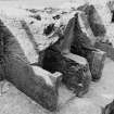
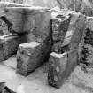
NM 83900 00860 (NM80SW 31) An excavation undertaken, May – June 2017, uncovered what appear to be hearth derived occupation deposits within what is probably the remnants of a dun structure located to the N of the castle. The excavation also confirmed the presence of structures lying immediately to the W of the castle, these were perhaps initially castle
outbuildings, but remained occupied after the castle’s demise in 1685. The excavation also investigated some of the buildings belonging to the township of Carnassarie Beg, the dating evidence confirming the historical picture of a settlement occupied until the middle of the 19th century. The
excavation also showed that within the castle grounds both the castle outbuildings and those of Carnassarie Beg have been substantially affected by tree root damage. Another theme encountered during the excavation work were the topographical changes resulting from various campaigns of ‘landscaping’ within the castle grounds. which appear to
have removed any trace of buildings near the ‘garden’ gate and have significantly raised ground levels immediately to the N of the castle.
Archive: Kilmartin Museum. Report: NRHE and WoSAS SMR
Funder: Historic Environment Scotland, A’Cruach Community Fund
Roddy Regan – Kilmartin Museum
(Source: DES, Volume 18)

