
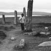
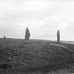
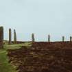
Ring Of Brodgar


Henge (Neolithic) - (Bronze Age), Rune Inscribed Stone (Norse), Stone Circle (Neolithic) - (Bronze Age)
Site Name Ring Of Brodgar
Classification Henge (Neolithic) - (Bronze Age), Rune Inscribed Stone (Norse), Stone Circle (Neolithic) - (Bronze Age)
Alternative Name(s) Ring Of Brogar; Ness Of Brodgar; Circle At Stennis
Canmore ID 1696
Site Number HY21SE 1
NGR HY 2945 1335
Datum OSGB36 - NGR
Permalink http://canmore.org.uk/site/1696


First 100 images shown. See the Collections panel (below) for a link to all digital images.
- Council Orkney Islands
- Parish Stenness
- Former Region Orkney Islands Area
- Former District Orkney
- Former County Orkney
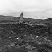
Ring of Brodgar, Orkney, runic inscribed standing stone
Measurements:
Stone type: sandstone
Place of discovery: HY 2949 1339
Present location: in situ on a stone in the northern part of the circle.
Evidence for discovery: found in 1906 during restoration work on the stone circle on a portion of stone that was later attached to its stump.
Present condition: good.
Description
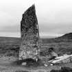
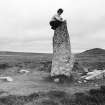
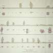
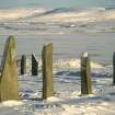
Carved on the inner face of the stone are five twig runes and a simple cross. Barnes and Page doubt the conventional reading of ‘Bjorn’.
Date: possibly Viking age.
References: Barnes & Page 2006, OR 4, 161-4.
Compiled by A Ritchie 2017
HY21SE 1 2945 1335.
(HY 2945 1335) Stone Circle of Brodgar (NR)
OS 6" map, Orkney, 2nd ed., (1903).
A single twig-rune is carved on a boulder in the SW region of the Ring.
M Olsen 1954.
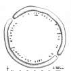
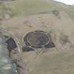
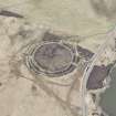
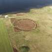
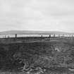
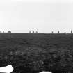
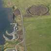
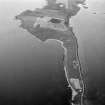
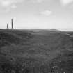
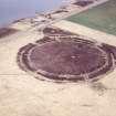
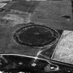
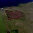
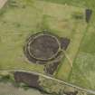
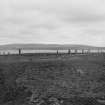
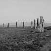
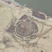
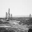
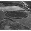
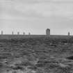
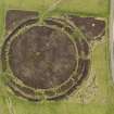
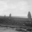
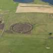
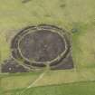
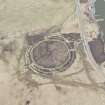
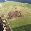
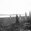
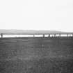
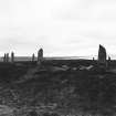
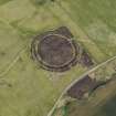
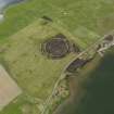
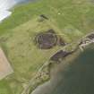
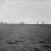
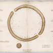
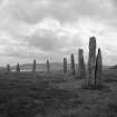
The 'Ring of Brodgar' is a Class II henge monument, under Historic Buildings and Monuments (HBM) Guardianship, incorporating a stone circle 370 ft in diameter. It is bounded by a well-preserved ditch 30 ft wide and 6 ft deep.
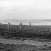
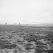
The monoliths are mounted at intervals just within the scarp of the enclosing ditch. The positions of at 1 least 40 have been identified: of these, 27 remain upright.
Stone no.3 bears on one of its faces a number of, as yet, unsatisfactorily translated tree-runes and, below them, a small incised cross of simple design. A small stone bearing a tree-rune and a small incised cross was found in the circle during restoration by the Ministry of Works.
RCAHMS 1946; V G Childe and W D Simpson 1961; F T Wainwright 1962.
Visible on air photograph CUCAP GR 44, flown 1951.
The Ring of Brogar (name confirmed locally and appearing on MPBW guide-post) is as described and planned by previous authorities. The ditch is 10.0 m. wide and varies in depth from 0.9m to 1.9 m. The boulder, containing the single twig-rune, could not be located.
Resurveyed at 1/2500.
Visited by OS (RB) 24 April 1966.
Radiocarbon Dates:
SRR 502 Basal organic deposits overlying deep silt infill in north ditch section - depth 0.7m Organic Mud 255bc +-60 375BC +-80
SRR 503 Lower peat in north ditch section - depth 0.6m Organic Mud 375bc +-45 440BC +-70
J L Davidson and A S Henshall 1989.
Holes measuring 800 x 700mm and 180-230mm deep were dug for plaques at three sites in the parish of Stenness, Mainland Orkney. One hole was located near the Ring of Brogar (HY 2946 1346; HY21SE 1), one at the Stones of Stenness (HY 3071 1239; HY21SW 2) and one at Maes Howe (HY 3180 1272). Nothing of archaeological significance was discovered in any of the holes.
Sponsor: Historic Scotland
P Sharman 2000
In 1892 'The Orkney Herald' reported that stones from a dyke end were used in the Ring of Brodgar. Other mentions of the site are made in 'The Orkney Herald' and 'The Orcadian' - see References.
'The Orkney Herald' reported the discovery of runes on a stone stump uncovered in remedial work (1907). In 1908 7 stones were re-erected and an axe was found. The site was described in a number of articles.
M Howe 2006
'The Orcadian' in 1906 mentioned that the largest stone had been re-erected, after being knocked down in around 1814.
M Howe 2006
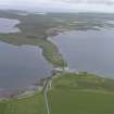
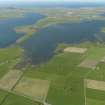
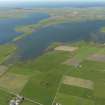
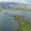
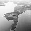
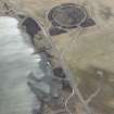
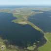
A programme of archaeological evaluation was undertaken at the site of the proposed Dyke O Sean visitor car park servicing the UNESCO designated World Heritage site of the Ring of Brodgar in Steness Parish, Orkney. The site is centred on HY 29329 13738, on the eastern shore of the Brodgar Isthmus on the promontory between the Loch of Harray to the east, and the Loch of Stenness to the west. From the site, the sites of the Ring of Brodgar (c.300 m to the S), the Stones of Stenness (1.8km to the SE) and Maes Howe (2.6km to the E) are visible.
Twelve machine-dug trenches were opened across the area of the proposed development with two additional hand-dug cuttings made over two small upstanding mounds within the development area. No archaeological remains were identified within the machine cut trenches and the low mounds were proven to represent cleared material from modern (post-World Warr II) activity at the site. The findings from the evaluation can now be used to assist guidance of the appropriate management of the site operations involved in the construction of the car park.
M Carruthers 2006
The visitor car park has now been completed with display boards and is centred at HY 29487 13503.
Visited by RCAHMS (DE) 15 September 2008
Excavation (1973)
In 1973 three sections were cut across the ditch of the Ring of Brogar, on behalf of the Department of the Environment, with the aim of obtaining samples for radiocarbon analysis.
C Renfrew 1979, 40
Publication Account (1996)
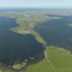
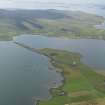
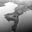
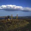
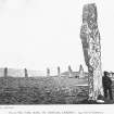
The Ness of Brodgar was a perfect place to choose for a great ceremonial monument, giving the impression of being surrounded by water and sky and yet firmly in the fertile heart of Orkney. Its open location is echoed by the vastness of the circle. In essence, this is a henge monument with two entrances enclosing a prefect circle of standing stones, 103.7m in diameter; there is no trace of a bank, despite the great volume of rock and soil that must have been dug out of the ditch, about 10m wide at ground-level and more than 3m deep (now half-full of silt). In the mid 19th century only fourteen stones were standing, but others have been re-erected so that there are twenty-seven standing, and the positions are known of another thirteen; assuming that the stones were put up at approximately equal distances, it is likely that there were originally sixty stones in the circle. Apart from those surviving as broken stumps, the existing stones vary between about 2m and 4.5m in height. It has been suggested that the circle was designed as a lunar observatory, using the Hellia Cliff on Hoy which is outlined on the horizon as a foresight, but the date at which this could have been possible is calculated at c1500 BC, which is almost certainly much later than the date of construction. As yet there is no precise dating evidence but the early to mid 3rd millennium would be the most likely context. There has been no excavation within the circle to discover whether any trace exists of internal structures.
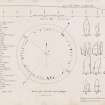
Sometime in the 12th century, a Norse visitor carved his name on the south face of one of the stones in the northernmost arc of the circle (the third stone to the north of the entrance); the stone is now a broken stump, but his runic letters are clear, together with a small cross incised beneath them. These are twig runes or tree runes, so called from their appearance, and they are cryptographic but easily read by counting the branches on either side of each rune and then reading off the number on the "following table: counting (from the right) gives 12 (mistakenly written 21 on the rune) 2334 r (as an ordinary rune) 22. Reading from the lefthand side and then the top of the table, these pairs of numbers give biorn, a common man's same even today, Bjorn.
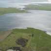
There are two very large burial mounds to the north-east of the Ring of Brodgar, between the modern road and the loch, and another large mound, known as Salt Knowe, to the west; smaller mounds are scattered over the Ness of Brodgar from south of the great circle to the Ring of Bookan to the north , but very little is known of their contents or date. Close to the shore of the loch to the north-west of the Ring is a large disc barrow, so-called because the burial mound is surrounded at a short distance by a bank. This type of barrow was fashionable in southern England but is rarely found in Scotland, underlining the direct links with the far south that are demonstrated by the rich burial at Knowes of Trotty (no. 69).
North of Brodgar, the Ring of Bookan may be another, smaller henge monument (HY 283144), while to the immediate east is a standing stone known as the Comet Stone, set on a low platform on which the stumps of two more stones are visible. A pair of standing stones, some 8m apart, adorn the very tip of the promontory near Brodgar farm (HY 303128). It seems likely that in prehistoric times the promontories of Brodgar and Stenness were still joined as a narrow neck of land.
Information from ‘Exploring Scotland’s Heritage: Orkney’, (1996).
Watching Brief (24 April 2000 - 28 April 2000)
Archaeological monitoring was required at Maes Howe between the 26th and the 28th of April while a programme of rewiring was undertaken. The work involved shallow excavations both within the main chamber of the monument and on the overlying mound. No finds were recovered.
At the same time Holes measuring 800 x 700mm and 180-230mm deep were dug for plaques at three sites in the parish of Stenness, Mainland Orkney. One hole was located near the Ring of Brogar (HY 2946 1346; HY21SE 1), one at the Stones of Stenness (HY 3071 1239; HY21SW 2) and one at Maes Howe (HY 3180 1272). Nothing of archaeological significance was discovered in any of the holes.
Sponsor: Historic Scotland
D Stewart and P Sharman 2000
Kirkdale Archaeology
Magnetometry (June 2002 - October 2002)
A geophysical survey using magnetometry was undertaken in and around the Heart of Neolithic Orkney World Heritage Site between June and October 2002. Over 30ha was surveyed, including the Ring of Brodgar, the fields to the S of the Stones of Stenness (including Big Howe, HY31SW 31), an area around Bookan chambered cairn, and the fields between Brodgar Farm and the Bridge of Brodgar. Preliminary results have clarified the extent of known sites and discovered several new ones.
Archive to be deposited in Orkney SMR and the NMRS.
Sponsors: HS, Orkney Islands Council, Orkney Archaeology Trust, Orkney College.
N Card 2002
Magnetometry (June 2002 - October 2002)
A geophysical survey using magnetometry was undertaken in and around the Heart of Neolithic Orkney World Heritage Site between June and October 2002. Over 30ha was surveyed, including the Ring of Brodgar, the fields to the S of the Stones of Stenness (including Big Howe, HY 31 SW 31), an area around Bookan chambered cairn, and the fields between Brodgar Farm and the Bridge of Brodgar. Preliminary results have clarified the extent of known sites and discovered several new ones.
Archive to be deposited in Orkney SMR and the NMRS.
Sponsors: HS, Orkney Islands Council, Orkney Archaeology Trust, Orkney College.
N Card 2002
Magnetometry (2003)
A second season of magnetometry survey was undertaken in and around the Heart of Neolithic Orkney World Heritage SIte. Over 30ha was surveyed, further clarifying the extent of known sites and locating many new ones. Further survey in the immediate environs of The Ring of Brodgar seemed to emphasise the lack of magnetic enhancement in this area. This is in marked contrast to the area around the Stones of Stenness and on the Ness of Brodgar.
Report to be lodged with Orkney SMR and the NMRS.
Sponsors: HS, Orkney Islands Council, GSB (Bradford), Orkney Archaeology Trust.
Project (January 2005 - November 2005)
HY 3 1 (vicinity) A fourth season of geophysical survey was undertaken between January and November 2005 in and around the Heart of Neolithic Orkney World Heritage Site (DES 2004, 97). This included more than 40ha of gradiometer survey, together with targeted resistance and ground penetrating radar (GPR).
GPR survey was conducted over Salt Knowe (HY 293 132) and Fresh Knowe (HY 296 133). However, the nature of the ground cover caused poor contact and considerable attenuation of the signal, resulting in little useful data being retrieved.
Reports lodged with Orkney SMR and NMRS.
Sponsors: HS A, Orkney Islands Council, Orkney Archaeological Trust, Orkney College Geophysics Unit.
N Card and S Ovenden 2005
Ground Penetrating Radar (January 2005 - November 2005)
HY 3 1 (vicinity) Ground penetrating radar survey.
Reports lodged with Orkney SMR and NMRS.
Sponsors: HS A, Orkney Islands Council, Orkney Archaeological Trust, Orkney College Geophysics Unit.
N Card and S Ovenden 2005
Earth Resistance Survey (January 2005 - November 2005)
HY 3 1 (vicinity) Resistance survey.
Reports lodged with Orkney SMR and NMRS.
Sponsors: HS A, Orkney Islands Council, Orkney Archaeological Trust, Orkney College Geophysics Unit.
N Card and S Ovenden 2005
Magnetometry (January 2005 - November 2005)
HY 3 1 (vicinity) Magnetometry survey.
Reports lodged with Orkney SMR and NMRS.
Sponsors: HS A, Orkney Islands Council, Orkney Archaeological Trust, Orkney College Geophysics Unit.
N Card and S Ovenden 2005
Excavation (7 July 2008 - 1 August 2008)
HY 2945 1335 Two trenches were excavated across the ditch at opposite ends of the Ring of Brodgar from 7 July–1 August 2008 as part of a larger programme of work. The trenches re-excavated and slightly extended Trenches A and C from Colin Renfrew’s 1973 investigations and focussed on the removal of ditch fills to obtain material for a range of dating applications.
The rock-cut ditch in Trench A, which was abandoned in 1973 due to waterlogging, was shown to have been quarried out in segments and provides the first clear evidence for the method of excavation, suggesting that the great ditch was dug in sections over a period of time, and/or that various communities contributed to its construction. No tool marks were visible on the rock face and it is likely that the rock was excavated using wooden wedges.
In addition to the excavation of the ditch fills, a previously unrecorded stonehole was investigated in Trench C. The severe disturbance around the base of the cut for the stonehole indicates that this stone had been toppled in antiquity. This, along with the discovery of a ramp associated with the stonehole in Trench A, provides new information relating to the construction of the stone circle itself. No evidence for an internal or external bank associated with the monument was discovered during these excavations.
The analysis of the samples taken from the ditch fills in both trenches should provide significant new information about the construction and subsequent history of the monument.
J Downes and C RIchards, ORCA 2008
Report: Orkney SMR and RCAHMS (intended) Funder: Historic Scotland, Orkney Islands Council, Manchester University, ORCA and Orkney College
Project (July 2011)
HY 387 141 and HY 294 131 (centred on) Work on Holocene sea level change in Orkney indicates that relative sea levels only reached their present position some 4000 years ago. This project which was set up in 2005 aims to:
• construct a sea level curve to provide detail of former changes in relative sea level around Orkney
• investigate the possibility that remains of past human settlement might be preserved on the seabed.
The project combines various different strands of work including sediment coring, remote sensing, seismic survey, diving, intertidal survey, palaeoenvironmental analysis on land, in the intertidal zone and from submerged surfaces, aerial photography, archive searches, and ethnoarchaeology.
In June 2011, seismic survey in the Bay of Firth revealed detail of structural complexity within some of the main anomalies previously identified by sonar survey, suggesting an anthropogenic origin for these structures. The position of these sites within the submerged landscape suggests an Early Neolithic date. In addition, detail of the sediments within the Finstown Basin has been used to interpolate the existence of a small loch or lagoon prior to inundation. This is of particular relevance to an understanding of the Mesolithic use of the area. In September 2011 sediment cores were extracted from the Bay of Firth with the aim of building more detail into the environmental history of the area pre-inundation.
Work has also taken place in the Loch of Stenness. An initial sonar survey around the SE shores has revealed a number of potential anomalies in close proximity to the World Heritage sites at Ring of Brodgar and the Stones of Stenness, and to the excavations at Ness of Brodgar. These will be investigated further in 2012 and the extent of the survey extended.
Dates from the Lochs of Stenness and Harray, and from Mill Bay, Hoy and Dam of Hoxa, South Ronaldsay have added to the detailed sea level history of the islands.
Archive: Contributors (currently). ADS, Orkney SMR and RCAHMS (intended)
Funder: Historic Scotland, Scapa Flow Landscape Partnership, Society of Antiquaries of London and Royal Archaeological Institute
University of Aberdeen, University of Dundee, University of St Andrews, University of Wales, Trinity St David, and University of Bangor, 2011
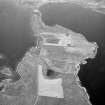
Archaeological Evaluation (28 August 2012 - 2 September 2012)
HY 294 133 (centred on) A series of 17 trenches was excavated, 28 August – 2 September 2012, to establish the depth of added soil around the eastern half of the Ring of Brodgar. A coherent sequence of deposits, showing variable depths of added soil was recorded in all of the trenches. Most of the trenches contained silty clay dumped on the underlying peat. Two trenches contained gravel laid over black plastic sheeting, while others contained plastic netting or bedding sand directly below the topsoil. The depth of the introduced deposits varied both within and between trenches, but they were on average 100–150mm thick and 2m wide. The deposits often seemed to fill hollows in the underlying peat, suggesting a complicated sequence of repair, carried out where and when it was needed.
Archive: RCAHMS (intended)
Funder: Historic Scotland
David Murray, Kirkdale Archaeology 2012
OASIS ID: kirkdale1-310759
Field Visit (March 2012 - December 2012)
HY 387 141 and HY 294 131 (centred on) Work on Holocene sea level change in Orkney indicates that relative sea levels only reached their present position some 4000 years ago. This project which was set up in 2005 aims to:
construct a sea level curve to provide detail of former changes in relative sea level around Orkney
investigate the possibility that remains of past human settlement might be preserved on the seabed.
The project combines different strands of work including sediment coring, remote sensing, seismic survey, diving, intertidal survey, palaeoenvironmental analysis on land, in the intertidal zone and from submerged surfaces, aerial photography, archive searches, and ethnoarchaeology.
In March – December 2012 work focused on coring in the Bay of Firth with the aim of investigating organic deposits below the present seabed, perhaps indicative of a lake or lagoon prior to inundation by the sea. Preliminary analysis of the core sediments shows a clear transgression, evident in both microfossils and molluscs, from fresh water to saline. Particle size suggests a lower energy environment after inundation. Dates from this core should help to identify the date of inundation.
In the Loch of Stenness a number of anomalies were identified in 2011, in particular a long mound to the N of the Seatter embayment, and an annular feature offshore to the S of the Ring of Brodgar. Seismic survey was undertaken across these anomalies and suggested that they may be anthropogenic (archaeological) in origin. Other work focused on modelling the pre-submerged landscape of Orkney and this will continue in 2013.
Archive: Contributors (currently)
Funder: Historic Scotland, Society of Antiquaries of London, Royal Archaeological Institute and Leverhulme Trust
CR Wickham-Jones, University of Aberdeen
S Dawson, University of Dundee
R Bates, University of St Andrews
M Bates, University of Wales Trinity Saint David
D Huws, University of Bangor
2012
Excavation (August 2013)
HY 2945 1335 Samples were collected in August 2013 from midden deposits at the Ness of Brodgar for micromorphology and phytolith analysis. The aims of this pilot project are to investigate differences in activities occurring in different parts of the site, and to investigate the types of plants being used for food and fuel. This will be achieved by combining microscopic analysis of midden stratigraphy with analysis of plant microfossil remains. This combination of methods has been successfully applied to Neolithic sites in other parts of the world, but so far has not been applied in the UK. Preliminary assessment of material in the field indicated a high potential for excellent preservation of microscopic features, and full analysis will be undertaken in 2014.
Report: Society of Antiquaries of Scotland. Digital data: ADS
Funder: Society of Antiquaries of Scotland and the Orkney Archaeology Society
Lisa-Marie Shillito, University of Edinburgh, 2013
(Source: DES)
Watching Brief (20 October 2014 - 29 October 2014)
HY 2943 1342 (centred on) A watching brief was carried out, 20–29 October 2014, during the removal of turf as part of remedial works to improve drainage. It was possible to carry out the work without excavating beyond the recently added clayey soil, turf, stone chips and terram, or the apparently undisturbed peat towards the W end of the excavated area. No deposits of archaeological sensitivity or significance were exposed or disturbed.
Archive: National Record of the Historic Environment (NRHE)
Funder: Historic Environment Scotland
Andrew Hollinrake – Kirkdale Archaeology
(Source: DES, Volume 16)
Watching Brief (31 May 2016 - 8 June 2016)
Under the terms of its PIC call-off contract with Historic Environment Scotland, Kirkdale Archaeology was asked to undertake a watching brief during further work to remedy poor drainage in the area of the footpath leading to the Ring of Brodgar. The current approach to the site is from a car park located to the north of the monument. Visitors cross the public road to a footpath leading to the site, and it is this footpath that is often waterlogged at its down-slope, northern end. The intention was to excavate a 250mm deep track below the existing surface, to be infilled with pea gravel. A 'grass-crete' covering would then be emplaced over this and seeded.
The first phase of this work was carried out during March 20161 and comprised the excavation of a 55m long x 2m wide trench running parallel to the nearby road. The second phase of work involved the excavation of a trench of the same depth and width, starting just south-east of the finishing point of the earlier work. The excavation was carried out with a small, mechanical digger with a flat-bladed bucket, under archaeological supervision, and was carried out over two days, 13th and 22nd April, 2016.
The sequence of deposits varied little throughout the excavation, as seen in the area excavated previously. The only variation seen was in the depth of soil encountered beneath the topsoil and over the clay, but even that was slight and was rendered more noticeable since the variation occurred near the depth of excavation.
A Hollinrake 2016
Sponsor: Historic Scotland
Kirkdale Archaeology
Watching Brief (1 May 2017 - 31 May 2017)
HY 294 133 A watching brief was carried out, May 2017, during path remediation work within the scheduled area at the Ring of Brodgar Stone Circle. Small areas of turf/ topsoil were excavated to create a level area that was then built up to form a new path surface. No finds or features of archaeological significance were recorded.
Archive: NRHE (intended). Report: Orkney SMR
Funder: Historic Environment Scotland
Graeme Carruthers – CFA Archaeology Ltd
(Source: DES, Volume 18)
Orkney Smr Note
'The very ancient circular range of upright stones at Stenness, in the island of Pomona in Orkney, which was reared in honour of the sun; While a contiguous semicircular pile was dedicated to the moon ...The site of these remarkable piles of stones is on the banks
of the Loch of Steinhouse ...' [R1]
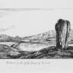
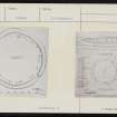
Thomas describes the state of the circle and gives various dimensions of the monoliths. There is a plan showing the remaining stones and the sites of stones no longer present. [R2]
Relates the discovery of a broken part of one of the ruined stones with an inscription. [R3]
Reports discovery (fuller than P.S.A.S.) and gives photographs. Olsen attempts transcription followed by a
discussion. [R4]
First discovered in 1906. A tracing and cast of the runes were taken by Mr. J.W. Cursiter and submitted to Prof. Magnus Olsen of Christiania who interpreted their meaning. [R5]
There is a good description and the usual measurements are given. [R6]
The Ring of Brodgar stands on a narrow neck of undulating moorland between the Lochs of Harray and Stenness. 'It is of special interest and importance on account of the great extent of the area enclosed, the relative perfection of the ring of monoliths, and the presence of a wide and deep ditch which
completely surrounds it. 'The ditch measures about 30ft in breadth and is about 6ft deep.'
The central area measures about 370ft in diameter. At the time of writing, the positions of at least forty are visible, and there are spaces for twenty more, if it be assumed that they were erected at approx. equal distances apart. This would bring up the total in the original plan to sixty. By 1929 only twenty-seven were still erect. Some of the stones have runic inscriptions. Also a rough stone axe, a hammer-stone of quartz, and a small stone, bearing a tree rune and a small arrowhead of reddish coloured flint was picked up in 1928 close to the N.W. traverse. [R7]
Information from Orkney SMR [n.d.]
Magnetometry
HY 30 13 (area) A third season of geophysical survey was undertaken between March and October 2004 in and around the 'Heart of Neolithic Orkney' World Heritage Site (DES 2003, 102). Over 35ha were surveyed using magnetometry. Results have further clarified the extent of known sites and discovered many new ones.
Further survey between the Ness of Brodgar and the Ring of Brodgar (centre HY 299 131) revealed boundary features, possible unknown burnt mounds and barrows, and areas of general background increased magnetic response. This response is similar to that surrounding the Neolithic complex on the Ness of Brodgar, which test pitting has shown is the result of Neolithic midden-enhanced soils.
The area to the NW of Maes Howe (centre HY 314 129) was dominated by geological anomalies and modern disturbance. However, isolated features may represent a possible new settlement site and other archaeological features.
A variety of responses have been detected to the SW of Maes Howe (centre HY 314 126). The northern half of the area is dominated by zones of magnetic disturbance generated by igneous dikes, and throughout the area short linear ferrous-type responses have been noted which are consistent with a series of land drains. Potentially archaeologically significant anomalies have been noted in the SW, including weak suggestions of an oval enclosure and general areas of increased magnetic response. In addition, a group of well-defined anomalies suggesting possible enclosures has been located further S.
Reports lodged with Orkney SMR and the NMRS.
Sponsors: HS, Orkney Islands Council, GSB (Bradford), Orkney Archaeological Trust, Orkney College.
N Card and S Ovenden 2004

