
Pricing Change
New pricing for orders of material from this site will come into place shortly. Charges for supply of digital images, digitisation on demand, prints and licensing will be altered.
Easter Rarichie


Dun (Prehistoric)(Possible), Fort (Prehistoric)
Site Name Easter Rarichie
Classification Dun (Prehistoric)(Possible), Fort (Prehistoric)
Canmore ID 15300
Site Number NH87SW 6
NGR NH 8434 7360
Datum OSGB36 - NGR
Permalink http://canmore.org.uk/site/15300


- Council Highland
- Parish Nigg (Ross And Cromarty)
- Former Region Highland
- Former District Ross And Cromarty
- Former County Ross And Cromarty
NH87SW 6 8434 7360.
(NH 8434 7360) Danish Fort (NR)
OS 6" map, Ross-shire, 2nd ed., (1907)
Fort, Easter Rarichie: This fort is situated on a knoll which rises from the lower part of the NE slope of the Hill of Nigg, 650 yards S of Easter Rarichie farmhouse. The remains are ruinous, having suffered from stone-robbing and the encroachment of the plough as well as from natural decay. They consist of several separate features, the innermost of which is a small stone-walled structure which crowns the knoll. This is represented by a stony mound about 12' in thickness surrounding an area about 35' in diameter. On the N arc several continuous outer facing stones still remain in situ and there is a gap in the SE arc that represents an entrance. The thickness of the wall suggests that the structure may have been a dun. (A more ruinous example of a similar structure, with an internal diameter of about 30' is situated on a small knoll 200 yds to the W.) The dun stands within the slight remains of a stone wall (I) which enclose an area 170' E-W by 80'. For the most part this feature now appears only as a slight scarp from which a few boulders protrude. The entrance is in the SE. A second wall (II) lies below this to enclose an area measuring 210' E-W by 160'. Although it is as ruinous as wall I, more loose boulders and stones occur along its course. The entrance is in the E.
The ruin of wall II overlies the N, S, and W arcs of rampart III, the E part of which runs off beyond the points where the E arc of wall II turns. This rampart, now a mere crest-line above the scarped flanks of the knoll, encloses and area 300' E-W by 160'. The entrance is in the E. The next line of defence is a rampart (IV) partly formed by adapting the lowest part of the knoll and partly by a rubble mound. The whole of the S sector of this rampart lay on level ground below the knoll, and was entirely removed when the land on which it was built was ploughed. The slight remains of a similar rampart (V) lie outside the SE arc of IV, and appear to have been truncated in the same way.
It is possible to suggest that at least two main structural phases can be distinguished among the six defensive features that are crowded on to the knoll, despite their ruinous condition. The original work may have consisted of rampart III as the innermost line, and IV and V as its outer defences. The second phase may be represented at least by walls I and II, and possibly by the dun as well. The dun, however, may represent a third, separate, phase of occupation.
New Statistical Account (NSA) 1845; Name Book 1872; Information from RCAHMS TS, 15 May 1957.
A fort consisting of three ruinous walls and two outer ramparts, with a later circular structure crowning the top of the summit.
The latter consists of a circular turf-covered wall about 3.5m thick, and 17.5m in diameter with an entrance in the SE. Undoubtedly a dwelling, this is more likely to be a strong hut circle, rather than a robbed dun; it overlies the W arc of the fort wall. This wall, representing the innermost of the fort defences, is reduced to a stony scarp, completely destroyed in the N, and has enclosed an oval area measuring about 30.0m E-W by 10.0m. Outside, is another wall (RCAHMS's wall I) which has enclosed an oval area about 43.0m E-W by 26.0m whilst the third wall (RCAHMS's wall II) has occupied the N, W and S rims of a steep slope above the inner rampart, and is in a similar state of preservation to the other two. There is no trace of the rampart which it is alleged to overlie. It appears to have enclosed an area of c. 67.0m by 50.0m, but has now been reduced to a slight scarp. The inner rampart, is as described by the RCAHMS. The entrance, in the E, is offset. As well as the short section of outer rampart surviving in the SE, a smaller section is evident in the W. Undoubtedly this rampart, like the inner one, once encircled the S arc of the knoll, but it has never completed the circuit in the N.
The defences are partly obscured by whins and bracken; the sequence of fortification and the number of periods represented is uncertain, but there is little doubt that the circular structure, perhaps best classified as a homestead, was constructed after the fort had fallen into disuse.
Resurveyed at 1:2500.
Visited by OS (A A) 18 September 1972.
A multivallate fort occupying a knoll which provides an excellent defensive location. The circular stone-walled structure on the summit overlying the innermost rampart of the fort as described by the previous OS field investigator, appears on balance to be a dun rather than a hut circle, a hypothesis based on its defensive position, its overall size and relatively thick wall, although it is severely reduced and no evidence of its construction is exposed. (See also NH87SW 8).
Visited by OS (N K B) 10 March 1981.
Field Visit (15 May 1957)
Fort, Easter Rarichie:
This fort is situated on a knoll which rises from the lower part of the NE slope of the Hill of Nigg, 650 yards S of Easter Rarichie farmhouse. The remains are ruinous, having suffered from stone-robbing and the encroachment of the plough as well as from natural decay. They consist of several separate features, the innermost of which is a small stone-walled structure which crowns the knoll. This is represented by a stony mound about 12 feet in thickness surrounding an area about 35 feet in diameter. On the N arc several continuous outer facing stones still remain in situ and there is a gap in the SE arc that represents an entrance. The thickness of the wall suggests that the structure may have been a dun (A more ruinous example of a similar structure NH87SW 8, with an internal diameter of about 30' is situated on a small knoll 200 yards to the W). The dun stands within the slight remains of a stone wall (I) which enclose an area 170 feet from E to W by 80 feet transversely. For the most part this feature now appears only as a slight scarp from which a few boulders protrude. The entrance is in the SE. A second wall (II) lies below this to enclose an area measuring 210 feet from E to W by 160 feet transversely. Although it is as ruinous as wall I, more loose boulders and stones occur along its course. The entrance is in the E.
The ruin of wall II overlies the N, S, and W arcs of rampart III, the E part of which runs off beyond the points where the E arc of wall II turns. This rampart, now a mere crest-line above the scarped flanks of the knoll, encloses and area 300 feet from E to W by 160 feet transversely, and the entrance is in the E. The next line of defence is a rampart (IV) partly formed by adapting the lowest part of the knoll and partly by a rubble mound. The whole of the S sector of this rampart lay on level ground below the knoll, and was entirely removed when the land on which it was built was ploughed. The slight remains of a similar rampart (V) lie outside the SE arc of IV, and appear to have been truncated in the same way.
It is possible to suggest that at least two main structural phases can be distinguished among the six defensive features that are crowded on to the knoll, despite their ruinous condition. The original work may have consisted of rampart III as the innermost line, and those numbered IV and V as its outer defences. The second phase may be represented at least by the walls I and II, and possibly by the dun as well. It must always be borne in mind that the dun may represent a third, separate, phase of occupation.
NH 844 735, OS Sheet lv
Visited by RCAHMS 15 May 1957
Desk Based Assessment (7 January 1964)
(NH 8434 7360) Danish Fort (NR)
OS 6" map, Ross-shire, 2nd ed., (1907)
Fort, Easter Rarichie: This fort is situated on a knoll which rises from the lower part of the NE slope of the Hill of Nigg, 650 yards S of Easter Rarichie farmhouse. The remains are ruinous, having suffered from stone-robbing and the encroachment of the plough as well as from natural decay. They consist of several separate features, the innermost of which is a small stone-walled structure which crowns the knoll. This is represented by a stony mound about 12' in thickness surrounding an area about 35' in diameter. On the N arc several continuous outer facing stones still remain in situ and there is a gap in the SE arc that represents an entrance. The thickness of the wall suggests that the structure may have been a dun. (A more ruinous example of a similar structure, with an internal diameter of about 30' is situated on a small knoll 200 yds to the W.) The dun stands within the slight remains of a stone wall (I) which enclose an area 170' E-W by 80'. For the most part this feature now appears only as a slight scarp from which a few boulders protrude. The entrance is in the SE. A second wall (II) lies below this to enclose an area measuring 210' E-W by 160'. Although it is as ruinous as wall I, more loose boulders and stones occur along its course. The entrance is in the E.
The ruin of wall II overlies the N, S, and W arcs of rampart III, the E part of which runs off beyond the points where the E arc of wall II turns. This rampart, now a mere crest-line above the scarped flanks of the knoll, encloses and area 300' E-W by 160'. The entrance is in the E. The next line of defence is a rampart (IV) partly formed by adapting the lowest part of the knoll and partly by a rubble mound. The whole of the S sector of this rampart lay on level ground below the knoll, and was entirely removed when the land on which it was built was ploughed. The slight remains of a similar rampart (V) lie outside the SE arc of IV, and appear to have been truncated in the same way.
It is possible to suggest that at least two main structural phases can be distinguished among the six defensive features that are crowded on to the knoll, despite their ruinous condition. The original work may have consisted of rampart III as the innermost line, and IV and V as its outer defences. The second phase may be represented at least by walls I and II, and possibly by the dun as well. The dun, however, may represent a third, separate, phase of occupation.
Information from OS (BRS) 7 January 1964
Sources: New Statistical Account (NSA) 1845; Name Book 1872; Information from RCAHMS TS, 15 May 1957.
Field Visit (19 September 1972)
A fort consisting of three ruinous walls and two outer ramparts, with a later circular structure crowning the top of the summit.
The latter consists of a circular turf-covered wall about 3.5m thick, and 17.5m in diameter with an entrance in the SE. Undoubtedly a dwelling, this is more likely to be a strong hut circle, rather than a robbed dun; it overlies the W arc of the fort wall. This wall, representing the innermost of the fort defences, is reduced to a stony scarp, completely destroyed in the N, and has enclosed an oval area measuring about 30.0m E-W by 10.0m. Outside, is another wall (RCAHMS's wall I) which has enclosed an oval area about 43.0m E-W by 26.0m whilst the third wall (RCAHMS's wall II) has occupied the N, W and S rims of a steep slope above the inner rampart, and is in a similar state of preservation to the other two. There is no trace of the rampart which it is alleged to overlie. It appears to have enclosed an area of c. 67.0m by 50.0m, but has now been reduced to a slight scarp. The inner rampart, is as described by the RCAHMS. The entrance, in the E, is offset. As well as the short section of outer rampart surviving in the SE, a smaller section is evident in the W. Undoubtedly this rampart, like the inner one, once encircled the S arc of the knoll, but it has never completed the circuit in the N.
The defences are partly obscured by whins and bracken; the sequence of fortification and the number of periods represented is uncertain, but there is little doubt that the circular structure, perhaps best classified as a homestead, was constructed after the fort had fallen into disuse.
Resurveyed at 1:2500.
Visited by OS (A A) 18 September 197
Field Visit (September 1977)
Easter Rarichie NH 843 736 NH87SW 6
This complex multi-period fort stands on a prominent knoll rising from the lower slopes of the Hill of Nigg. The defences comprise three ramparts, two walls and an inner enclosure which may be a dun.
RCAHMS 1979, visited September 1977
(NMRS no. RCD/2/1; NSA, xiv Ross and Cromarty, 20)
Field Visit (10 March 1981)
A multivallate fort occupying a knoll which provides an excellent defensive location. The circular stone-walled structure on the summit overlying the innermost rampart of the fort as described by the previous OS field investigator, appears on balance to be a dun rather than a hut circle, a hypothesis based on its defensive position, its overall size and relatively thick wall, although it is severely reduced and no evidence of its construction is exposed. (See also NH87SW 8).
Visited by OS (N K B) 10 March 1981.
Measured Survey (28 January 2013 - 29 January 2013)
A sketch plan of Easter Rarichie fort was produced by George Geddes (RCAHMS) and Candy Hatherley (University of Aberdeen) between 28-29 January 2013. The sketch plan was developed using the RCAHMS 1957 plan (RCD 2/1), the 1977 amended copy (RCD 2/2) and ground observations.
Geophysical Survey (2013)
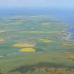
NH 8434 7360 (Easter Rarichie) and NH 8406 7366 (Wester Rarichie) Two excavation sessions were undertaken in 2013 at Easter and Wester Rarichie, by a team from the Department of Archaeology at the University of Aberdeen. The sites are located on two rocky knolls c180m apart at the base of the NE slopes of the Hill of Nigg, on the E coast of the Tarbat Peninsula. The hill of Easter Rarichie is occupied by a multivallate hill fort crowned by a stone and rubble built roundhouse or dun at its summit. The site on Wester Rarichie hill consists of a turf walled roundhouse and a series of ditches and banks located on a summit plateau. Both are prominent hills in the landscape and command clear views across the Tarbat peninsula and the Dornoch and Moray Firths.
Geophysical and measured surveys were undertaken on the sites in January 2013, and two phases of excavations and further geophysical surveys were undertaken in April and July 2013. Four trenches were excavated on Easter Rarichie, targeting the roundhouse, the rampart walls encircling it and a flat terrace area on the lower slopes. On Wester Rarichie a single trench was excavated through the summit roundhouse.
The excavations on Easter Rarichie identified a well preserved stone built roundhouse with internal postholes, occupation surfaces and a stone-built hearth. A trench through the two walls enclosing the summit showed these to be stone-faced earth and rubble walls. Activity in the form of postholes, midden deposits and paved areas was identified in the areas between the rampart walls. The terrace trench identified a series of paved areas, postholes and a metalled surface. A fragment of shale bracelet was recovered from a posthole within the interior of the roundhouse, and animal bone was retrieved from a number of deposits within each of the trenches.
A single radiocarbon date of c400–205 cal BC (SUERC-46744) was obtained from a layer of charcoal underlying the stone wall of the summit roundhouse. A further six radiocarbon samples have now been submitted from various deposits.
The trench across the earthen bank and its interior on the summit of Wester Rarichie identified the structure as a turf walled roundhouse. Within the interior a series of postholes and one end of a possible rectangular structure with a well-worn entranceway were identified. Animal bone and fragments of burnt clay were recovered from a number of features within the interior of the roundhouse, and a fragment of cannel coal bracelet was recovered from one of the postholes. Radiocarbon samples from the internal features of the dun have been submitted.
Archive: RCAHMS
Funder: University of Aberdeen Development Trust in partnership with the Tarbat Discovery Centre
Candy Hatherley and Gordon Noble, University of Aberdeen, 2013
(Source: DES)
Note (23 March 2015 - 19 May 2016)
This fortification crowns a steep-sided knoll at the foot of the NE flank of the Hill of Nigg. The visible remains comprise two elements: a thick-walled round-house enclosed within up to two outer walls occupying the very top of the knoll; and a larger outer enclosure taking in the whole of the summit area and protected by a massive ditch and rampart encircling its foot. In 2013 Candy Hatherley excavated evaluation trenches across the Inner round-house, which measures about 10.5m in diameter within a wall 3m in thickness, and its outer walls. Radiocarbon dates from a range of contexts suggest that these elements of the occupation date 400-200 BC; the outer works, however, remain undated. These latter probably accompany a rampart following the shoulder of the knoll to form an oval enclosure measuring up to 80m from E to W by 48m transversely (0.32ha), though the rampart itself is reduced to little more than a stony scarp and on the E appears to become the outermost wall enclosing this side of the thick-walled round-house. The flanks of the knoll may have been scarped in places, falling away steeply into the bottom of a broad external ditch with an external earthen rampart, which is best preserved in the NE, SE and NW sectors. There is also an outer bank on the SE. The entrance is on the E and approaches the summit up a sloping ramp from the NE.
Information from An Atlas of Hillforts of Great Britain and Ireland – 19 May 2016. Atlas of Hillforts SC2912

