
Pricing Change
New pricing for orders of material from this site will come into place shortly. Charges for supply of digital images, digitisation on demand, prints and licensing will be altered.
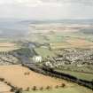
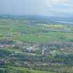
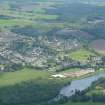
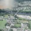
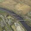
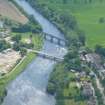
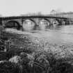
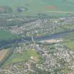
Maryburgh, Conon Bridge


Road Bridge (Period Unassigned)
Site Name Maryburgh, Conon Bridge
Classification Road Bridge (Period Unassigned)
Alternative Name(s) River Conon; Bridge Pool
Canmore ID 12813
Site Number NH55NW 39
NGR NH 54081 55857
Datum OSGB36 - NGR
Permalink http://canmore.org.uk/site/12813


- Council Highland
- Parish Fodderty
- Former Region Highland
- Former District Ross And Cromarty
- Former County Ross And Cromarty
NH55NW 39 54081 55857
Conon Bridge [NAT]
OS (GIS) MasterMap, February 2010.
Location formerly entered as NH 540 557 and NH 5401 5584.
Formerly also entered as NH55NW 187 at cited location NH 54083 55862.
For (adjacent) Maryburgh, tollhouse, see NH55NW 35.
For (predecessor) Telford bridge (at NH c. 5403 5581), see NH55NW 189.
For corresponding railway bridge (adjacent to SW), see NH55NW 32.
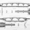
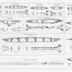
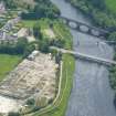
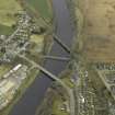
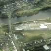
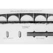
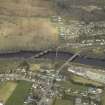
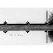
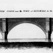
This bridge carries the A862 public road (formerly the A9) across the River Conon between the villages of Conon Bridge (in the parish of Urquhart and Logie Wester) and Maryburgh (in the parish of Fodderty), to the S and N respectively. The original (now-demolished) five-arched bridge (NH55NW 189) was designed by Thomas Telford in 1806-9, and the present bridge by James Arrol (county surveyor) in 1969.
The available map evidence (GIS MasterMap) indicates that that brisdge extends from NH c. 54064 55893 to NH c. 54105 55814.
Information from RCAHMS (RJCM), 1 July 2009.
J Gifford 1992; E Beaton 1992.

