
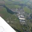
Mannsfield Showground, Muir Of Ord


Recreation Ground (Period Unassigned)
Site Name Mannsfield Showground, Muir Of Ord
Classification Recreation Ground (Period Unassigned)
Canmore ID 12695
Site Number NH54NW 35
NGR NH 533 491
Datum OSGB36 - NGR
Permalink http://canmore.org.uk/site/12695


- Council Highland
- Parish Urray (Ross And Cromarty)
- Former Region Highland
- Former District Ross And Cromarty
- Former County Ross And Cromarty

