
Gilchrist


Promontory Fort (Prehistoric) - (Early Medieval)
Site Name Gilchrist
Classification Promontory Fort (Prehistoric) - (Early Medieval)
Canmore ID 12690
Site Number NH54NW 30
NGR NH 53730 49324
Datum OSGB36 - NGR
Permalink http://canmore.org.uk/site/12690


- Council Highland
- Parish Urray (Ross And Cromarty)
- Former Region Highland
- Former District Ross And Cromarty
- Former County Ross And Cromarty
Field Visit (January 1978)
Gilchrist NH 537 493 NH54NW
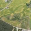
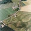
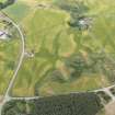
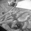
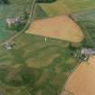
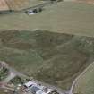
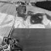
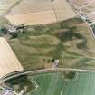
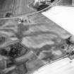
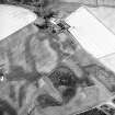
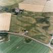
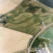
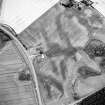
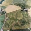
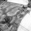
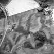
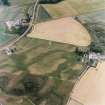
Crop-marks on air photographs show the arcs of three concentric ditches in an arable field 250m NW of Gilchrist farmhouse. Apparently designed to cut off approach to a tongue of low-lying and comparatively level ground running NW into marshland, they are in effect part of the defensive system of a promontory fort measuring about 85m by 30m. Visible on RCAHMS APs 1977.
RCAHMS 1979, visited January 1978
Field Visit (January 1978)
Gilchrist NH 537 493 NH54NW
Crop-marks on air photographs show the arcs of three concentric ditches in an arable field 250m NW of Gilchrist farmhouse. Apparently designed to cut off approach to a tongue of low-lying and comparatively level ground running NW into marshland, they are in effect part of the defensive system of a promontory fort measuring about 85m by 30m.
RCAHMS 1979, visited January 1978
Note (6 March 2015 - 18 May 2016)
This fort occupies a narrow tongue of slightly raised ground forming a promontory running out into boggy ground on the WNW. Its defences comprise three concentric ditches between 2m and 3m in breadth, which are drawn in a belt about 15m deep across the root of the promontory on the ESE. The interior measures about 105m in length from ESE to WNW, and while the promontory itself is no more than 40m in breadth, it opens out immediately behind the defences to a maximum of 60m (0.4ha). The entrance is probably on the SE, where the defences extend about 20m beyond the margin of the promontory; in most of the photographs available this area is lost in field-edge effects, but on photographs taken by Jim Bone (see Highland HER) the two outer ditches appear to unite to form a rounded terminal.
Information from An Atlas of Hillforts of Great Britain and Ireland – 18 May 2016. Atlas of Hillforts SC2884
Excavation (September 2018)
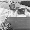
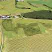
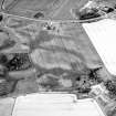
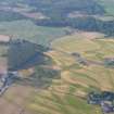
NH 53700 49300 A programme of work was undertaken, 7 – 16 September 2018, at Gilchrist. This monument was only previously known from cropmarks on aerial photographs. The aerial photograph shows, three dark curved features representing the ditches of a fort. The interior of the fort is represented by a ridge of higher and drier ground running westwards and surrounded by an area of low-lying marsh – a late glacial kettlehole that over several thousand years has formed an extensive peat bog.
The large ditches seen on the aerial photograph cut off the landward end of the promontory, while the other three sides of the promontory were protected by the peat bog. After the fort went out of use, the original ditches were filled in and ploughed flat, and there is nothing to see above ground today. It is only the cropmarks on the aerial photographs that have allowed archaeologists to see this as a fortified promontory; promontory forts are more usually found on the coast where banks and ditches cut off a headland.
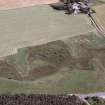
A mechanical digger was employed to open three large trenches, one running at right angles across the defensive ditches, a second running from the long side of the fort down into the bog and a third on the highest part of the interior of the fort.
Removal of the topsoil showed that the three ditches seen on aerial photographs did exist and there was even a hint of a fourth ditch closer to the fort. The ditches had been constructed with varying widths and depths. The outermost ditch was reasonably shallow but the second ditch was a massive construction, 5 or 6m wide at the top and sloping steeply to about 1.5m below the ploughsoil, though the upper part of the ditches have probably been lost due to ploughing, and any intervening banks of excavated material have been flattened. The next innermost ditch was not quite so deep, and on the edge of the actual fort area a possible fourth ditch was revealed, which might have continued round the fort perimeter as a wall or timber fence or palisade.
The excavators were impressed by the scale of the defences and now consider that what was originally thought to be a fairly insignificant fort was in fact a major construction that took a huge amount of labour to build. It must also have been a considerable task to fill in and level the largest ditches with field gathered pebbles and boulders. It is thought this was done during the medieval period, as a small amount of medieval pottery and a metal blade were found within the ditch fill. The nearby medieval church of Gilchrist functioned as Tarradale parish church until the late 16th century and the infilling of the fort ditches may represent land improvement for agriculture as the small settlement at Gilchrist developed.
The trench that was dug from the interior of the site N across the long side of the fort into the bog also proved to be very interesting. As the summer in 2018 was dry it was possible to extend the trench into the peat bog, but it soon filled up with water. As the trench approached the bog the remains of what could have been a wall or dyke running along the N side of the promontory were encountered, and below that, where the ground dropped very steeply into the bog, large pieces of timber were found, which might be the remains of fallen trees, but might equally represent part of a structure such as a palisade or fence associated with the fort. Finds of several pieces of pottery trapped within the remains of the supposed perimeter wall or dyke, as well as part of a rotary quern stone, probably represent rubbish thrown over the side of the fort. The pottery, probably from a large handmade clay cooking pot, was very fragmentary and some of the fragments were only recovered from post-excavation sieving of bulk soil samples. Once this pottery is analysed, it may give some clue as to when the fort was in use, and radiocarbon dating of pieces of charcoal from the same trench should also give some indication as to when the charcoal was deposited.
The trench on the highest part of the fort interior showed parallel furrows at the base of the topsoil representing old plough marks, but it appears that ploughing activity in recent times on the higher interior of the fort has destroyed some of the evidence there and much of the soil has been displaced downhill. However, the team were encouraged to open a fourth trench further W but still within the fort perimeter, where aerial photographs suggested there was a change in soil conditions. This was indeed the case as just under the topsoil was a spread of clay, too regular and straight sided to be a natural deposit and the tentative suggestion is that it may be a floor of a building within the fort. Just on top of this clay floor was a small piece of pottery, possibly part of a small crucible, suggesting that small-scale metalworking was being carried out on the site, and this would tie in well with what we know from other elite occupation sites. Only a tiny percentage of the fort's area has been investigated, but the evidence to date suggests that between 1500 and 2800 years ago someone important at Gilchrist had sufficient power or status to commission the construction of a defensive site of some significance.
Archive and report: NOSAS
Funder: Heritage Lottery Fund
Website: www.tarradalethroughtime.co.uk
Andy Young and Eric Grant – Tarradale Archaeological Project
(Source: DES Volume 19)
Excavation (6 September 2018 - 20 September 2018)
NH 5369 4933 (Gilchrist) and NH 5426 4902 (Balvattie) These excavations formed part of the Tarradale Through Time community archaeology project, and involved archaeological investigation of two sites revealed by cropmarks. The work took place 6-20 September 2018.
The fieldwork at the Gilchrist site involved the excavation of four evaluation trenches (Project Trenches 1, 2, 7 and 9), which were opened in agricultural land and adjacent rough ground. The trenches confirmed the presence of buried archaeological deposits and features consistent with an enclosure bounded on the E side by a series of four concentric ditches of differing sizes, three of which were previously indicated by aerial photographs, and marshland on the remaining three sides. A trench opened down the N flank of the enclosure, into the adjacent peat bog and wetland, revealed evidence for a further, lateral, ditch and the remains of an associated lateral boundary, probably a wall, indicated by cobblestones and rubble. Charred plant remains, pottery sherds and a schist quernstone were retrieved from behind this feature. Deposits of peat had accumulated against the outer face of the boundary feature. Excavation of the peat for the recovery of environmental columns revealed a large waterlogged timber tapered to a rough point, possibly a structural stake or pile.
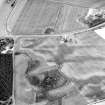
A further small trench was opened towards the western end of the promontory to examine the location of a prominent cropmark visible on aerial photographs. The cutting revealed a shallowly buried layer of very well consolidated clay and small stones, the upper surface of which was scoured by plough marks. The deposit was tentatively interpreted to reflect the remains of a rammed clay floor. The presence of the deposit raises the possibility that a more extensive structure or structures, contemporary with the construction and use of the promontory enclosure, are preserved at that location.
Fieldwork at the Balvattie site involved the excavation of five evaluation trenches (Project Trenches 3, 4, 5, 6 and 8), each of which targeted separate cropmark features visible on aerial photographs. The trenches confirmed the presence of buried archaeological deposits consistent with aerial photographs at some locations although two of the five cuttings were archaeologically sterile. Excavated features included a recut ditch and a series of associated post-pits, postholes, a linear ditch and a spread hearth deposit in Trench 3, the former consistent with a large circular enclosure indicated by a well-defined cropmark on aerial photographs. Trench 4 was opened over the location of a large sub-circular cropmark and revealed a large pit up to 1.5m deep of unknown function. The pit contained a sequence of well-defined fill deposits which indicate that it may have been open for an extended period and filled with differing source material in a series of discreet episodes. Trench 6 revealed part of a deep straight-sided ditch with a squared terminal, which had a deep posthole directly adjacent to the terminal. The features recorded in Trench 3 produced just a few sherds of stratified later prehistoric pottery although most other features identified in the trenches were aceramic. The ditch recorded in Trench 6 also failed to produce any dating evidence. Deposits containing charred plant material were identified in Trenches 3 and 4. Evaluation Trenches 5 and 8 failed to locate any significant archaeological deposits.
The primary fieldwork evidence indicates that most of the archaeological activity identified on the site is likely to be of later prehistoric origin and associated with a series of circular or rectilinear enclosures, most likely agricultural, which appear to have been located some distance from the focus of associated occupation. Evidence for later, medieval and post medieval, activity on the site was restricted to a small collection of pottery sherds. No substantial evidence for intensive settlement-related medieval activity was identified.
Report: Highland HER Records and NRHE
Funder: Tarradale Through Time project (NOSAS) funded by HLF and HES
Andrew Young - Highland Archaeology Services Limited
(Source: DES Vol 20)

