
Inverness, Caledonian Canal, Clachnaharry


Canal (Period Unassigned)
Site Name Inverness, Caledonian Canal, Clachnaharry
Classification Canal (Period Unassigned)
Canmore ID 105851
Site Number NH64NW 30
NGR NH 6488 4656
NGR Description NH 6499 4647 to NH 6445 4675
Datum OSGB36 - NGR
Permalink http://canmore.org.uk/site/105851
Ordnance Survey licence number AC0000807262. All rights reserved.
Canmore Disclaimer.
© Copyright and database right 2024.
- Correction
- Favourite

DP 015088
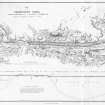
Engraving of elevation and plan inscr: ''Map of the Caledonian Canal or Inland Navigation between the Eastern and Western Sea capable of admitting a frigate of 32 guns.'' Includes longitudinal section.
© RCAHMS

SC 1675850
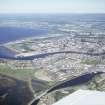
Aerial photograph showing Clachnaharry Sea Lock and Lock Keeper's House
RCAHMS Aerial Photography
1985
© Crown Copyright: HES

SC 1675853
Aerial photograph showing Clachnaharry Sea Lock and Lock Keeper's House
RCAHMS Aerial Photography
1985
© Crown Copyright: HES


SC 434976
Inverness, Clachnaharry Sea Lock Basin View from SE showing Eilean Dubh in first pound of basin
Papers of Professor John R Hume, economic and industrial historian, Glasgow, Scotland
12/5/1974
© HES. Reproduced courtesy of J R Hume

SC 1675852
Aerial photograph showing Clachnharry Sea Lock and Lock Keeper's House
RCAHMS Aerial Photography
1985
© Crown Copyright: HES

SC 1863127
Vertical aerial view of Clachnaharry Lock, Caledonian Canal, Inverness, looking NW.
Papers of James Sloan Bone, landscape historian, Inverness, Highland, Scotland
1988
© NOSAS (James S Bone Collection). Courtesy of HES


SC 2560238
General view of Clachnaharry Railway Swing Bridge from south east
1974
© RCAHMS


SC 434970
Inverness, Clachnaharry Sea Lock and Lock Keeper's House Distant view from S
Papers of Professor John R Hume, economic and industrial historian, Glasgow, Scotland
12/5/1974
© HES. Reproduced courtesy of J R Hume

SC 434978
Inverness, Clachnaharry Sea Lock Basin View from W showing Eilean Dubh in first pound of basin
Papers of Professor John R Hume, economic and industrial historian, Glasgow, Scotland
12/5/1974
© HES. Reproduced courtesy of J R Hume

SC 509283
Inverness, Clachnaharry Lock View from SE showing Lochaber II
Papers of Professor John R Hume, economic and industrial historian, Glasgow, Scotland
3/2/1977
© HES. Reproduced courtesy of J R Hume

DP 152730
Workshop lock showing slot for former manual operating chains/cables on north bank
Scottish Canals
13/5/2013

SC 1675851
Aerial photograph showing Clachnaharry Lock and Lock Keeper's House
RCAHMS Aerial Photography
1985
© Crown Copyright: HES

SC 1675855
Clachnaharry Sea Lock and Lock Keeper's House. Aerial photograph.
RCAHMS Aerial Photography
1985
© Crown Copyright: HES

SC 2364205
Inverness, Caledonian Canal, Clachnaharry, NH64NW 30, Ordnance Survey index card, Recto
Records of the Ordnance Survey, Southampton, Hampshire, England
1958
© Crown Copyright: HES (Ordnance Survey Archaeology Division Collection)

SC 2364206
Inverness, Caledonian Canal, Clachnaharry, NH64NW 30, Ordnance Survey index card, Recto
Records of the Ordnance Survey, Southampton, Hampshire, England
1958
© Crown Copyright: HES (Ordnance Survey Archaeology Division Collection)

SC 2560243
General view of Clachnaharry Lock, Canal Workshops from east
1974
© RCAHMS

SC 2560244
General view of Clachnaharry Lock, Canal Workshops from east
1974
© RCAHMS


SC 434973
Inverness, Clachnaharry Railway Swing Bridge View from W
Papers of Professor John R Hume, economic and industrial historian, Glasgow, Scotland
12/5/1974
© HES. Reproduced courtesy of J R Hume

SC 799643
Aerial photographs showing Clachnaharry Sea Lock and Lock Keeper's House Digital image of A 36842.
RCAHMS Aerial Photography
1985
© Crown Copyright: HES

SC 1675849
Aerial photographs showing Clachnaharry Sea Lock and Lock Keeper's House
RCAHMS Aerial Photography
1985
© Crown Copyright: HES

SC 1863123
Aerial view of Muirtown Basin, Inverness, looking SE.
Papers of James Sloan Bone, landscape historian, Inverness, Highland, Scotland
1988
© Courtesy of HES (James S Bone)

SC 1967544
Aerial view of mouth of Caledonian Canal at Clachnaharry, Inverness, looking SE.
Papers of James Sloan Bone, landscape historian, Inverness, Highland, Scotland
7/1997
© Courtesy of HES (James S Bone)


SC 2560255
Clachnaharry Sea Lock: entrance locks and Lock Keeper's House from south west
1983
© RCAHMS

SC 799647
Aerial photograph showing Clachnaharry Lock and Lock Keeper's House Digital image of A 36844.
RCAHMS Aerial Photography
1985
© Crown Copyright: HES

SC 1675847
Aerial view showing Clachnaharry Locks, Workshops, Railway Swing Bridge
RCAHMS Aerial Photography
1985
© Crown Copyright: HES

SC 1675854
Aerial photograph showing Clachnaharry Sea Lock and Lock Keeper's House
RCAHMS Aerial Photography
1985
© Crown Copyright: HES

SC 1924545
General view of Clachnaharry Sea Locks and Lock Keeper's House
1984
© RCAHMS

SC 2560252
General view down tracks towards Clachnaharry Station Signal Box
1975
© RCAHMS

SC 399147
Clachnaharry Sea Lock and Lock Keeper's House. Aerial photograph.
© RCAHMS

SC 1967661
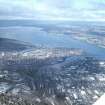
Aerial view of Inverness and the Beauly Firth, looking WNW.
Papers of James Sloan Bone, landscape historian, Inverness, Highland, Scotland
3/2005
© Courtesy of HES (James S Bone)

SC 2560239
General view of Clachnaharry Railway Swing Bridge from south east
1974
© RCAHMS

SC 799648
Aerial photograph showing Clachnaharry Sea Lock and Lock Keeper's House Digital image of A 36846.
RCAHMS Aerial Photography
1985
© Crown Copyright: HES

SC 1021810
Longitudinal section and plan of sea lock at Clachnaharry, Caledonian Canal.
c. 1838
© RCAHMS

SC 1675848
Aerial view showing Clachnaharry Locks, Workshops and Railway Swing Bridge
RCAHMS Aerial Photography
1985
© Crown Copyright: HES

SC 1967540
Aerial view of Caledonian Canal and mouth of River Ness at Muirtown, Inverness, looking SE.
Papers of James Sloan Bone, landscape historian, Inverness, Highland, Scotland
7/1997
© Courtesy of HES (James S Bone)

SC 434974
Inverness, Clachnaharry Lock View from SW showing lock gates and capstan
Papers of Professor John R Hume, economic and industrial historian, Glasgow, Scotland
12/5/1974
© HES. Reproduced courtesy of J R Hume

SC 509282
Inverness, Clachnaharry Lock View from NW showing lock gate on slip
Papers of Professor John R Hume, economic and industrial historian, Glasgow, Scotland
3/2/1977
© HES. Reproduced courtesy of J R Hume

SC 799640
Aerial view showing Clachnaharry Locks, Workshops, Railway Swing Bridge Digital image of A 36840.
RCAHMS Aerial Photography
1985
© Crown Copyright: HES

SC 1924546
General view of Clachnaharry Sea Locks and Lock Keeper's House
1984
© RCAHMS

DP 342964
Aerial view of Inverness and the Beauly Firth, looking W.
Papers of James Sloan Bone, landscape historian, Inverness, Highland, Scotland
20/3/2013
© Courtesy of HES (James S Bone Collection)


- Council Highland
- Parish Inverness And Bona
- Former Region Highland
- Former District Inverness
- Former County Inverness-shire

