
Pricing Change
New pricing for orders of material from this site will come into place shortly. Charges for supply of digital images, digitisation on demand, prints and licensing will be altered.
Upcoming Maintenance
Please be advised that this website will undergo scheduled maintenance on the following dates:
Thursday, 9 January: 11:00 AM - 3:00 PM
Thursday, 23 January: 11:00 AM - 3:00 PM
Thursday, 30 January: 11:00 AM - 3:00 PM
During these times, some functionality such as image purchasing may be temporarily unavailable. We apologise for any inconvenience this may cause.
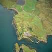
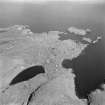
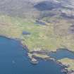
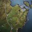
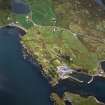
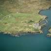
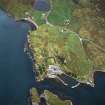
Harris, Rodel Harbour


Building (18th Century), Harbour (18th Century)
Site Name Harris, Rodel Harbour
Classification Building (18th Century), Harbour (18th Century)
Canmore ID 10522
Site Number NG08SW 8
NGR NG 04867 82809
Datum OSGB36 - NGR
Permalink http://canmore.org.uk/site/10522


- Council Western Isles
- Parish Harris
- Former Region Western Isles Islands Area
- Former District Western Isles
- Former County Inverness-shire
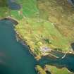
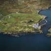
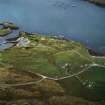
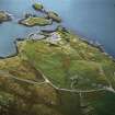
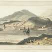
Rodel harbour, c.1785 Preceding Tarbert as the island's principal settlement and landing place, this compact dock with associated buildings was built at a period of relative prosperity in Harris, when Rodel became the centre of an energetic fishing and kelping enterprise. It was the legacy of Capt. Alexander Macleod of Berneray (1716-1790), the model laird who bought Harris in 1779. A recognised landing place from an early date, with a change house by c.1750, Rodel was now provided with stone quays and an 'excellent graving bank'. Macleod set about deep sea fishing, building a 60' boathouse and other structures, including "a store-house for salt, casks, meal etc.... a manufacturing house for spinning woollen and linen thread, and twine for herring nets ... a school-house and public house ...corn and fulling mill operated by water wheel... St. Clement's was repaired, plantings and cart tracks introduced, and shoemakers, weavers, turners, wrights and masons encouraged. Several structures survive, but the scene at the end of the 20th century was one of needless dereliction and wasted potential.
Taken from "Western Seaboard: An Illustrated Architectural Guide", by Mary Miers, 2008. Published by the Rutland Press http://www.rias.org.uk

NG08SW 8 04867 82809
NG08SW 8.01 0486 8281 hand crane
(Location cited as NG 047 827). Harbour, Rodel, c. 1840 and later. A simple basin formed by two rubble piers, one of them straight with an angled head, and the other curved with a wood-jib post crane (NG08SW 8.01) at its head.
J R Hume 1977.
Rodel Harbour: Detail of hand-crane
This harbour dates from about 1840 and later. The basin is formed by two rubble piers, one of which is straight with an angled head; the other is curved.
J R Hume 1977.
Aerial Photography (May 1966)
Oblique aerial photographs of St Clements Church, Rodel, Harris, and the surrounding area, photographed by John Dewar in 1966.

