Accessibility

Font Size

100% 150% 200%

Background Colour

Default Contrast
Close Reset

RCAHMS County Inventory; Lanarkshire (Prehistoric and Roman Monuments)

Date 1965 - 1978

Event ID 1117693

Category Project

Type Project

Permalink http://canmore.org.uk/event/1117693

We, Your Majesty's Commissioners, appointed to make an Inventory of the Ancient and Historical Monuments and Constructions connected with or illustrative of the contemporary culture, civilisation and conditions of life of the people in Scotland from the earliest times to the year 1707, and such further Monuments and Constructions subsequent to that year as may seem in our discretion worthy of mention therein, and to specify those which seem most worthy of preservation, humbly present to Your Majesty the following Report, being the Twentieth Report on the work of the Commission since its first appointment.

We recall with pleasure Your Majesty's gracious acceptance of the volume embodying our Nineteenth Report with the Inventory of the Ancient Monuments of Lorn, on the occasion of Your Majesty's visit to our exhibition 'Recording Scotland's Heritage' in the Canongate Tolbooth, Edinburgh, on 9 July 1975.

It is with regret that we have to record the retirement of Mr A. Graham, M.A., F.S.A., Mr P. J. Nuttgens, M.A., Ph.D., R.I.B.A., and Professor Stuart Piggott, C.B.E., B. Litt.,D.Litt., F.B.A., F.S.A., F.R.S.E. Mr Graham served the Commission for almost forty years, initially as Secretary from 1935 to 1957 and then as a Commissioner, while Professor Piggott was a member of the Commission for thirty years (1946- 76).

We have to thank Your Majesty for the appointment to the Commission of Professor R. J. Cramp, B.Litt., M.A., F.S.A., and Mr H. M. Colvin, C.B.E., M.A., F.B.A., Hon. F.R.I.B.A., under Your Majesty's Royal Sign Warrants of 18 November 1974 and 14 December 1976 respectively, and for the reappointment of Professor G. Donaldson, Mr. J. D. Dunbar Nasmith, Professor A. A. M. Duncan, and Professor K. H. Jackson.

Following our usual practice we have prepared an illustrated Inventory of the Prehistoric and Roman monuments of Lanarkshire, which will be issued as a non-Parliamentary publication.

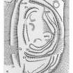
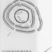
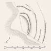
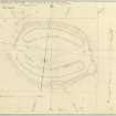
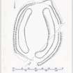
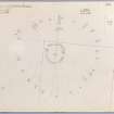
From the wide range of prehistoric monuments covered by the survey, the numerous Bronze Age cist-cemeteries are particularly worthy of mention. Records of these are often inadequate, but our re-examination and listing of the surviving relics have provided a firm basis for any future research in this field. Excavations which we have carried out on several Bronze Age burial-cairns have added significantly to our knowledge of their structure and date, while the opportunity has been taken to plan the major groups of small cairns, or 'cairnfields', that constitute one of the principal features of the archaeology of the county. The recognition of what may be the remains of a vast ritual enclosure at Blackshouse Burn is of exceptional interest, and air photography has revealed a large number of hitherto unknown sites, mostly in the form of crop-marks.

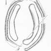
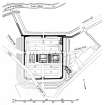
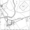
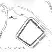
Lanarkshire also contains a rich variety of Roman military works. One of these, the watchtower at Beattock Summit, was discovered in the course of our survey, and we have undertaken limited, but productive, excavation on several other Roman sites, notably the forts at Crawford and Bothwellhaugh.

We wish to acknowledge the assistance accorded to us, during the preparation of this Inventory, by the owners and occupiers of the lands on which the monuments are situated. Our thanks are also due especially to Mr J. G. Scott, M.A., F.M.A., for placing unpublished material at our disposal; to Professor J. K. S. St. Joseph, O.B.E., M.A., Ph.D., F.S.A., Director in Aerial Photography in the University of Cambridge, for permission to reproduce a number of air photographs; to the Institute of Geological Sciences for advice on geological questions; to the staff of Hamilton District Museum for assistance in studying material in their care; to the Scottish Development Department for facilities for the study of air photographs; and to the staffs of the Department of the Environment, the Forestry Commission, the National Library of Scotland, the National Museum of Antiquities of Scotland, the Glasgow Art Gallery and Museum, the Hunterian Museum, University of Glasgow, the Archaeology Division of the Ordnance Survey and Your Majesty's Stationery Office, for continual and valued co-operation.

We wish again to place on record our appreciation of the high standard of work maintained by our executive staff, including those who are not employed in the preparation of the Inventories but on surveys or archival duties for the National Monuments Record of Scotland. In the present volume, the articles and sections of the Introduction dealing with prehistoric monuments have been written by Messrs A. MacLaren, M.A., F.S.A., G. S. Maxwell, M.A., F.S.A., J. N. G. Ritchie, M.A., Ph.D., F.S.A., J. B. Stevenson, B.A. and H. G. Welfare, B.A., M.Phil., and those dealing with Roman monuments by Mr Maxwell. The plans and other drawings have been produced by Messrs I. G. Scott, D.A., J. N. Stevenson, N.D.D., and I. G. Parker, and the photographs have been taken by Messrs G. B. Quick, A.I.I.P., A.R.P.S., C. R. Russell, J. D. Keggie, and J. M. Mackie. Miss A. E. H. Muir and Dr Ritchie have compiled the index and general assistance has been given by Miss M. Isbister and Mrs W. C. Chalmers. The volume has been edited by the Secretary and Mr MacLaren.

WEMYSS, Chairman

ROSEMARY CRAMP

HOWARD COLVIN

GORDON DONALDSON

JAMES DUNBAR-NASMITH

ARCHIBALD A. M. DUNCAN

KENNETH JACKSON

KENNETH STEER, Secretary

People and Organisations

Digital Images

View of platform within trees.
View of platform within trees.Publication plan of Cow Castle fort. Scanned image of photographic copy.Plan of the fort and linear earthworks. Scanned image of photographic copy.Publication drawing: Black Hill, Lesmahagow, fort and settlement. Scan of photographic copy.Publication drawing of the fort at Blackhill, Crawfordjohn. Scanned image of photographic copy.Publication plan of Fall Hill enclosed cremation cemetery. Scanned image of photographic copy.Publication drawing; field system and unenclosed platform settlement, Ellershie Hill. Photographic copy.Publication drawing: Normangill Henge. Scanned image of photographic copy.Publication drawing: henge at Weston. Scanned image of photographic copy.Publication drawing: plan of the Roman fort, Balmuildy; after S N MillerPublication drawing: general plan showing the Roman fort, bridge and temporary camp, Balmuildy.Publication drawing; general plan showing Roman fort and temporary camps, Crawford. Photographic copy. 
Publication drawing of the Roman fort, eastern annexe and enclosures at Castledykes. Photographic copy.Publication drawing of Bothwellhaugh Roman Fort and bath-house. Digital image of LAD/186/1/P.Publication drawing. Photographic copy.Publication drawing; excavation planPublication drawing; planPublication plan of Wandel Roman fortlet and temporary camp.Publication drawing; plan of Roman temporary camp, CornhillPublication plan of Fallburn fort. Scanned image of photographic copy.Publication drawing of Chester Hill fort. Scanned image of photographic copy.Publication plan of Devonshaw Hill fort and enclosure. Scanned image of photographic copy.View from EPublication drawing of the eastern annexe and enclosures at Castledykes Roman Fort.
Lanarkshire Inventory fig. 76.Plans of the different phases of Crawford Roman fort.
Lanarkshire Inventory fig. 80Publication drawing: unenclosed platform settlement and cairnfield, Normangill Rig (2).
Digital photographic copy.Publication plan: Blackshouse Burn.
Photographic copy.Publication plan: earthwork at Castle Qua.Publication drawing; plan of Hillhead moated site.Survey drawingPublication drawing; unenclosed platform settlement, Normangill Rig (3).
Cairn 2, from the W.Cairn 2, from the NE.Greens Moor, Cairn 2Publication plan of  Boatbridge Quarry cists. Digital image of original drawing.Publication plan of Patrickholm Sand Quarry Cist, reconstruction after J Harrison Maxwell 1947. Digital image of original drawing.Plane table survey of cairnfield, Horse Law, Sheet 1 of 3. Digital image of original drawing.Plane table survey of cairnfield, Horse Law, Sheet 2 of 3. Digital image of original drawing.Plane table survey of cairnfield, Horse Law, Sheet 3 of 3. Digital image of original drawing.Publication drawing; plan of cairnfield, Horse Law, northern half. Digital image of original drawing.Publication drawing; plan of cairnfield, Horse Law, southern half. Digital image of original drawing.Plane table survey plan of Fall Hill cremation cemetery. Digital image of original drawing.Publication plan of Fall Hill enclosed cremation cemetery. Digital image of original drawing.
Publication drawing; site plan, plan and sections of Beattock Summit Roman watch-tower. Digital image of original drawing.Publication plan and section of Baitaws cairn, and drawing of flint scraper, based on 1967 survey. Digital image of original drawing.Survey drawing of enclosure at Park Knowe. Digital image of original drawing.Inked plan of enclosure at Park Knowe. Digital image of original drawing.Publication plan and sections of Cairny excavation and small finds. Digital image of original drawing.Publication drawing of small finds from Cairny excavation. Digital image of original drawing.Excavation plan and sections of Cairny. Digital image of original drawing.Publication plan of settlement at Burries Burn, based on 1959 survey. Digital image of original drawing.Plane table survey of Cold Chapel settlement. Digital image of original drawing.Publication plan of Cold Chapel settlement, based on 1967 survey, with additions. Digital image of original drawing.Publication drawing of Devonside settlement. Digital image of original drawing.Publication drawing of Nisbet settlement. Digital image of original drawing.Publication drawing of St John's Kirk settlement. Digital image of original drawing.Publication drawing of Snaip Hill settlement, based on 1959 survey. Digital image of original drawing.Plane-table survey of Normangill henge.
Publication plan of Normangill henge, based on 1959 survey.
Also copy negative D15306
Plane table survey plan of Weston Henge.Publication plan of Weston henge, based on 1959 survey. 
Also copy negative D15308.
Plane table survey of Richie Ferry settlement, homestead and enclosure.Publication plan of Richie Ferry settlement, homestead and enclosure.Plane table survey of Richie Ferry enclosure.Publication plan of Richie Ferry enclosure, based on 1968 survey.Plane table survey of Blackhouse Burn ritual enclosure. Sheet 1 of 5.Plane table survey of Blackshouse Burn ritual enclosure. Sheet 2 of 5.Plane table survey of Blackshouse Burn ritual enclosure. Sheet 3 of 5.Plane table survey of Blackshouse Burn ritual enclosure. Sheet 4 of 5.Plane table survey of Blackshouse burn ritual enclosures. Sheet 5 of 5Plane table survey of Hurl Burn unenclosed platform settlement. Sheet 1 of 2.Plane table survey of Hurl Burn unenclosed platform settlement. Sheet 2 of 2.Plane table survey of Normangill Rig unenclosed platform settlement.Plane table survey of Normangill Rig unenclosed platform settlement.Plane table survey of Normangill unenclosed platform settlement. Sheet 1 of 2. Annotated 'the last plan made by RWF/KMF'Plane table survey of Normangill Rig unenclosed platform settlement. Sheet 2 of 2.Sketch map of site. The sites of the excavations of 1936 and 1939 are indicated by cross-hatching.Ink  drawing of exterior and interior of decorated slab from cist 4, Fernigair. Digital image of original drawing.Publication drawings of flake tool and an unworked flake from cist 1. Digital image of original drawing.Publication drawing; finds from burial 1: 3, cordoned urn; 4, archer's bracer. Digital image of original drawing.Drawings of encrusted urn from burial 1 and of food vessel from cist 2. Digital image of original drawing.Publication drawings; (7) enlarged food vessel, Burial 3; (8) beaker, Burial 4; (9) food vessel; (10) food vessel, cist 3; (11) food vessel. Digital image of original drawing.Excavation, view of cistExcavation, view of cistExcavation, view of cist and capstoneExcavation, view of cist and capstoneExcavation, view of cist.Cairn B or C after excavationFood Vessel recovered from cairnFood Vessel recovered from cairnFrom WSWPlatform from SWView of standing stone from S.View of cistView of cistDitch near entrance, NW side.From from Park Knowe (E)Inner bank near W entranceW arc of inner bank from NWGeneral view

First 100 images shown.

References