
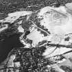
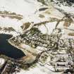
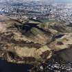
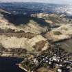
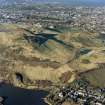
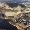
Edinburgh, Holyrood Park, Dunsapie


Cultivation Terrace(S) (Medieval)
Site Name Edinburgh, Holyrood Park, Dunsapie
Classification Cultivation Terrace(S) (Medieval)
Alternative Name(s) Queen's Park; Cultivation Terraces 1; Dunsapie Crag
Canmore ID 52102
Site Number NT27SE 102
NGR NT 28273 73006
Datum OSGB36 - NGR
Permalink http://canmore.org.uk/site/52102


- Council Edinburgh, City Of
- Parish Edinburgh (Edinburgh, City Of)
- Former Region Lothian
- Former District City Of Edinburgh
- Former County Midlothian
NT27SE 102 2825 7300
See also NT27SE 49.
(Centred NT 2825 7300) Cultivation Terraces (NR)
OS 6" map, (1966)
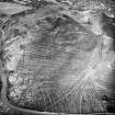
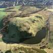
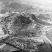
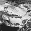
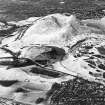
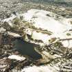
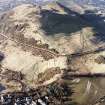
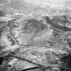
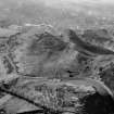
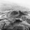
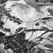
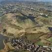
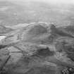
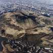
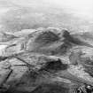
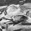
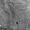
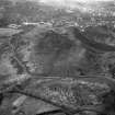
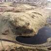
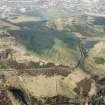
There are cultivation terraces to S and E of Dunsapie fort (NT27SE 49) - the latter outside park wall, under trees.
A Graham 1939; R B K Stevenson 1949; RCAHMS 1951.
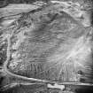
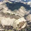
These cultivation terraces, averaging 4.0m wide with scarps averaging 1.5m high.
Visited by OS (S F S) 8 December 1975.
Publication Account (1951)
211. Cultivation Terraces, King's Park.
Cultivation terraces are to be seen at the following places in the King's Park:
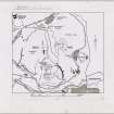
(i) [NT27SE 76, NT27SE 77 and NT27SE 135] On the E. slopes of Arthur's Seat, both above and below the Queen’s Drive. An account of these very striking group has already been published in the Inventory of Midlothian (1).
(ii) [NT27SE 102] To S. and E. of Dunsapie Fort (2) and extending E. of the fort outside the boundary wall of the Park [NT27SE 102]. (iii) [NT27SE 97] Immediately below the southernmost outcrop of the Echoing Rock; only the ends of two narrow terraces appear here, but it is possible that the broad rigs that cover the lower parts of this slope may have obliterated a group perhaps once comparable with those at Dunsapie.
(iv) [NT27SE 27] On the N.E. face of Haggis Knowe. At the bottom of the slope there are three long terraces, and above them some shorter and less well marked terraces and shelves.
RCAHMS 1951, visited c.1941
(1) No. 11. Cf. also P.S.A.S., lxxiii (1938-9), pp.289 ff., and lxxxi (1946-7), pp. 159 ff.
(2) Inventory of Midlothian and West Lothian, No. 10.
OS Map: Midlothian iii N.E. and S.E
Condition Survey (February 1996)
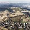
Survey confirmed the presence of the cultivation terraces previously described. At least seven denuded cultivation terraces are located on the south-eastern slopes of Dunsapie. Below these to the south-east are the residual remains of rig-and-furrow aligned east to west. The eastern side of these terraces, close to the park wall have been impinged upon by a small plantation of trees.
Information from Derek Alexander (Centre for Field Archaeology, University of Edinburgh) February 1997, no.29
Alexander 1997
Field Visit (15 December 1998)
Cultivation terraces lie to the NE and SE of Dunsapie Crag, immediately below the annexe of the fort NT27SE 49, and are plotted at 1:5,550 on an archaeological map of Holyrood Park (RCAHMS 1999). The group of terraces on the NE are aligned from N to S and extend obliquely across the hill-slope. They are narrowly spaced, measuring between 4m and 6m apart with scarps between 1m and 2m in height, and are probably the cumulative result of ploughing across the slope. Traces of rig-and-furrow cultivation lie immediately to the W, and may belong to the same agricultural system. The terraces of the second group, to the SE, are aligned from ENE to WSW and are between 4m and 11m broad with scarps 1m high. As they descend S into a boggy hollow, the terraces merge into rig-and-furrow suggesting that they too belong to the same agricultural system; the rigs measure between 6m and 7m in breadth.
Visited by RCAHMS (ARG), 15 December 1998.
NMRS, MS/726/96 (48-9, no. 29); RCAHMS 1999.
Condition Survey (12 March 2018 - 15 April 2018)
The 2018 CFA Archaeology Ltd condition survey found the site as previously described by Alexander (1997). The rig-and-furrow is not clear on the ground probably due to damage caused by plant involved in grass cutting and general erosion.
Information from Graeme Carruthers (CFA Archaeology Ltd) July 2018. OASIS ID: cfaarcha1-317194, no.29
Alexander 1997

