
Cairn Arc


Beacon (Medieval) - (Post Medieval)
Site Name Cairn Arc
Classification Beacon (Medieval) - (Post Medieval)
Alternative Name(s) Inverness Harbour, Beacon; River Ness
Canmore ID 13403
Site Number NH64NE 5
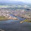
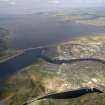
NGR NH 65974 47260
Datum OSGB36 - NGR
Permalink http://canmore.org.uk/site/13403


- Council Highland
- Parish Inverness And Bona
- Former Region Highland
- Former District Inverness
- Former County Inverness-shire
NH64NE 5 6597 4726
(NH 6597 4726) Cairn Arc (OE)
OS 6" map, (1938)
"Cairn Arc... This name is applied to an ancient cairn of stones situated near the end of the Breakwater at the mouth of the Ness. In it a post is set to warn approaching vessels fo the danger and hence its name "airc" (Gaelic) meaning danger. The Anglicized form is that now used by the Town Authorities."
Name Book 1868.
"There is at some distance from the mouth of the river Ness, a considerable way within flood mark, a large cairn of stones...It is called Cairnairc, that is, cairn of the sea. There is a beacon erected on Cairnairc, to apprize vessels coming into the river, of danger from it". Three cairns lie west fo Carinairc, in the Beauly Firth. In the most westerly, probably Carn Dubh (NH64NW 4) urns were found.
OSA 1793.
"Many urns and relics were found in these ( Carn-Arc, Carn-Dubh, Redcastle) and tradition has it that the level of this portion was higher of old than now and that the rivers Beauly and Ness ran down as rivers all the way to Fort George".
A Ross 1888.
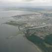
A line of boulders extends in a north-westerly direct- ion from the breakwater at the mouth of the River Ness for a distance of c. 50m terminating in a low mound of small stones c. 1m high and c. 6m across. This mound would appear to be all that remains of Cairn Airc. The line of boulders leading to the mound no doubt formed an earlier or additional breakwater with the cairn at the end, being utilised as a beacon as mentioned by Name Book 1878 and OSA 1793. The cairn is now in a very ruinous condition.
Visited by OS (W D J) 29 April 1960.
Note (1979)
Cairn Arc NH 659 472 NH64NE 5
A mound of stones, 6m across by 1 m high, situated about 50m NW of the breakwater atthe mouth of the River Ness, represents the remains of a beacon-stance.
RCAHMS 1979
Stat. Acct, ix, 1793, 631; Ross 1883, 66

