
Scheduled Maintenance
Please be advised that this website will undergo scheduled maintenance on the following dates: •
Tuesday 3rd December 11:00-15:00
During these times, some services may be temporarily unavailable. We apologise for any inconvenience this may cause.
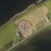
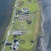
Ness Of Brodgar


Boundary Wall (Period Unassigned), Carved Stone (Period Unassigned), Cup And Ring Marked Stone (Prehistoric), Settlement (Neolithic), Stone (Period Unassigned), Mace(S) (Stone), Polished Axehead(S), Unidentified Pottery (Neolithic)
Site Name Ness Of Brodgar
Classification Boundary Wall (Period Unassigned), Carved Stone (Period Unassigned), Cup And Ring Marked Stone (Prehistoric), Settlement (Neolithic), Stone (Period Unassigned), Mace(S) (Stone), Polished Axehead(S), Unidentified Pottery (Neolithic)
Alternative Name(s) 'Great Wall Of Brodgar'; Stenness
Canmore ID 269123
Site Number HY31SW 112
NGR HY 3029 1285
Datum OSGB36 - NGR
Permalink http://canmore.org.uk/site/269123


- Council Orkney Islands
- Parish Stenness
- Former Region Orkney Islands Area
- Former District Orkney
- Former County Orkney
HY31SW 112 3029 1285
HY 303 128 A large, unusually notched and rebated stone was found during ploughing. A geophysical survey undertaken in 2002 (DES 2002, 88) had indicated considerable archaeological activity, especially in the southern portion of the field. Circular, rectangular and linear features were recorded which form part of a settlement complex continuing S into the adjoining property of Lochview. Also of importance is the generally increased magnetic response of the majority of the field. The opening of a 34.5m² trench in April 2003 revealed the presence of an arc of stones set on edge outlining part of a structure. Within the arc were the remains of a double-faced coursed wall forming two rectangular recesses or arms of a cruciform interior space. The building has been identified as a Late Neolithic building similar in form to others excavated at Barnhouse, barely 0.5km to the SE.
The trench exposed midden deposits which also lay between and around the building. These deposits were traced as a continuous feature in the southern extension of the trench. At its southern end, the midden was interrupted by stones forming part of another structure. These stones were similar to the notched stone and it is likely that this stone originated from this stonework or from the structure it represents.
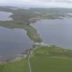
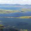
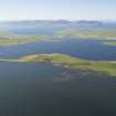
The site is well placed on high ground between the lochs of Stenness and Harray, close to the monuments of the Stones of Stenness and the Ring of Brodgar, and lies within the Inner Buffer Zone to the World Heritage Site of The Heart of Neolithic Orkney.
Report lodged with Orkney SMR and the NMRS.
Sponsor: HS
B Ballin Smith and G Petersen 2003
HY 303 129 Following exploratory excavation in April 2003 (see above), a resistivity survey in October 2003 both clarified the extent and nature of the anomalies shown by the previous magnetometry survey (DES 2002, 88) and also defined several new structures and features.
Report to be lodged with Orkney SMR and the NMRS.
Sponsor: Orkney Archaeology Trust.
N Card, A Mackintosh and D Damianoff 2003
HY 303 129 In light of discoveries on the Ness of Brodgar in recent years of a large prehistoric complex (DES 2003, 102-3), further evaluation and assessment of the site was undertaken in June 2004. Eight trial trenches were opened, showing that the dense concentration of features revealed by the geophysical surveys was only the 'tip of the iceberg'. Although the trenches were deliberately located away from significant geophysical anomalies, in only one trench was it possible to reach natural without structural archaeology being encountered.
The preliminary results appear to indicate that much of this substantial mound is artificial, comprising structures, middens and deep midden-enhanced soils dating to the Neolithic. In one trench part of a previously unrecorded chambered cairn was revealed. A substantial double linear feature revealed by resistivity, and thought prior to excavation to be probably medieval, now appears to be prehistoric and probably relates to other Neolithic activity on the site.
Soil samples were also obtained for research looking at wider issues, such as early land management, palaeoenvironments and other significant information relevant to the interpretation of the World Heritage Site.
Report lodged with Orkney SMR and the NMRS.
Sponsors: Orkney Islands Council, Orkney Archaeological Trust.
N Card and J Cluett 2004
Resistivity (October 2003)
HY 303 129 Following exploratory excavation in April 2003 (see above), a resistivity survey in October 2003 both clarified the extent and nature of the anomalies shown by the previous magnetometry survey (DES 2002, 88) and also defined several new structures and features.
Report to be lodged with Orkney SMR and the NMRS.
Sponsor: Orkney Archaeology Trust.
Trial Trench (June 2004)
HY 303 129 In light of discoveries on the Ness of Brodgar in recent years of a large prehistoric complex (DES 2003, 102-3), further evaluation and assessment of the site was undertaken in June 2004. Eight trial trenches were opened, showing that the dense concentration of features revealed by the geophysical surveys was only the 'tip of the iceberg'. Although the trenches were deliberately located away from significant geophysical anomalies, in only one trench was it possible to reach natural without structural archaeology being encountered.
The preliminary results appear to indicate that much of this substantial mound is artificial, comprising structures, middens and deep midden-enhanced soils dating to the Neolithic. In one trench part of a previously unrecorded chambered cairn was revealed. A substantial double linear feature revealed by resistivity, and thought prior to excavation to be probably medieval, now appears to be prehistoric and probably relates to other Neolithic activity on the site.
Soil samples were also obtained for research looking at wider issues, such as early land management, palaeoenvironments and other significant information relevant to the interpretation of the World Heritage Site.
Report lodged with Orkney SMR and the NMRS.
Sponsors: Orkney Islands Council, Orkney Archaeological Trust.
Excavation (2007)
HY 303 129 Further investigation of the large late Neolithic complex on the Ness of Brodgar was undertaken. Excavation continued on the large oval structure partially revealed in 2005 and 2006 (Trench J). The trench was expanded in order to uncover the full extent of this structure before dealing with in situ floor deposits. The depth and complexities of later activity represented by ephemeral structures, spreads of ash and midden prevented this being realised. The massive boulder wall that appeared to enclose this structure was revealed this season as having both and inner and outer wall face with a wall core of large boulders. Overall this wall was over 4m wide and survived to over 0.5m in height. Two new trenches (M and N) were located further across the peninsula over the line of this wall as indicated in the resistivity survey. These showed that this
monumental wall did originally extend across the peninsula. As in Trench J later Neolithic/early Bronze Age activity sealed the remains of this wall.
A polished stone macehead was recovered during topsoil removal of the Trench J extension. Two conjoining pieces of a thin stone slab decorated with incised geometric designs were also recovered. These joined with the decorated fragments discovered in 2006 in the upper fills of a nearby triangular stone cist.
Trench P (20 x 20m) was opened over the structure (Building 1) partially uncovered by GUARD in 2003 in order to uncover the full extent of this building (as indicated by magnetometry) and to explore its relationships with other elements on the Ness of Brodgar. In its original form Building 1 is very similar to Structure 2 at Barnhouse, but exhibits a complex structural history. In its later stages it was much reduced in internal area
with the insertion of a large curving wall across its centre creating a structure reminiscent of the building at Crossiecrown. Surrounding Building 1 were the remains of several other structures of sub-circular overall form and very regular angular and symmetrical layout.
Several examples of Neolithic art were found, with incised geometric designs similar to those discovered at Skara Brae on the walls of three separate structures in Trench P.
Report deposited in the Orkney SMR and RCAHMS.
Funder: Historic Scotland, Orkney Islands Council, Orkney Archaeological Trust, Orkney College, Russell Trust, Robert Kiln Trust, Friends of Orkney Archaeological Trust.
Excavation (7 July 2008 - 1 August 2008)
HY 303 129 Further investigation of the large late Neolithic complex on the Ness of Brodgar was undertaken in 2008 in order to characterise more of the structures and activity on the site. Excavation continued in Trench P (opened over Structure 1, partially uncovered by GUARD in 2003). The work clarified the relationship of several of the structures. A sondage against the outer wall face of Structure 1 revealed three courses of basal slabs at a depth of just over 1m from the surviving wall heads. These slabs projected beyond the outer wall line. The sondage also revealed a V-shaped stone-built drain and confirmed that Structure 1 had been constructed on midden deposits. The removal of more collapse and infill relating to the later reuse of Structure 1 revealed more phases of reuse and its replacement by several small sub-circular single-faced stone structures.
Trench P was enlarged to the SE by 20 x 20m to investigate the nature of a large rectangular structure indicated by geophysics. The extension revealed a large, sub-rectangular structure defined by a wall, c2m wide, with slightly obtuse external angles and rounded internal corners. In the excavated area this structure is c15 x 15m wide, but geophysics suggests that it continues to the E under the present house of Lochview. Several wall lines are becoming apparent but at present it is not clear if they represent an inner structure contemporary with this ‘outer enclosure’, or if they form a later structure built in the collapse of the former. The E–W configuration of this building aligns with the chambered tomb of Maes Howe to the E.
The Trench P extension also revealed the opposite side of Structure 8. This had been partially revealed last year and is less well preserved at this level. As previously a doubleskinned stone-faced wall with a midden wall core was revealed. Along their length were regular tapered stone-built divisions/piers creating very regular ‘recesses’ along each wall. This structure is c9m wide and as suggested by the geophysics 15m long.
Excavation was continued on the large oval structure, Trench J. The depth and complexities of later activity represented by ephemeral structures, hearths, spreads of ash and midden prevented the full extent of this structure being uncovered.
Trench N was opened in 2007 to investigate the massive boulder wall, the Great Wall of Brodgar which now seems to span the peninsula. It was further extended towards the Ring of Brodgar. This revealed that a ditch, c2m wide by 0.5m deep, had coexisted with and run parallel to the wall. A secondary wall had also been constructed on the inner lip of this ditch to increase the wall’s width from 4 to 6m at a later stage of its life. The ditch terminated in Trench N, implying the existence of an entrance through the wall just to the SW of Trench N.
Over 20 more examples of Neolithic art with incised geometric designs were found on the walls of several structures in Trench P and in the collapse of Structure 1. Other notable finds were a polished stone axe, half a cushion-style macehead, and a large quantity of Grooved Ware with both incised and applied decoration.
Overall the excavations suggest that in one of the later phases of the site several very large and regular stonebuilt structures were built, in use at the same time as and contained by the Great Wall of Brodgar. There were several more structures outside of the excavated areas suggested by the geophysical surveys.
N Card, ORCA and Orkney College 2008
Report: Orkney SMR and the RCAHMS Funder: Orkney Islands Council; Orkney Archaeological Trust, Orkney College, Robert Kiln Trust and Friends of Orkney Archaeological Trust.
Excavation (20 July 2009 - 28 August 2009)
HY 303 129 Further investigation of the large late Neolithic complex on the Ness of Brodgar was undertaken 20 July–28 August 2009 in order to characterise more of the structures and activity on the site.
Excavation of Structure 1 was continued and the removal of collapse and infill relating to the later reuse of the structure revealed more phases of its reuse. A short curving section of wall revealed last year has proved to be part of a suboval feature set into the later much smaller remodelling of Structure 1. The floor and occupation deposits in the late sub-oval Structure 7 were also examined. These mainly consisted of ashy spreads from a central square stone hearth.
Further work to define Structure 10 (the very large structure revealed in 2008) revealed a main structure, c15 x 15m, with an outer ‘forecourt’ area that extended out of the trench under the house of Lochview. The central ‘zigzag’ section of walling discovered last year and considered a later insertion formed part of a central cruciform chamber with a Skara Brae style ‘dresser’ present in one recess. The use of non-local red and yellow sandstone and ‘display art’ (cup marks, cup and ring and deeply incised geometric designs) characterised the chamber. The chamber was defined by walls c5m in overall thickness consisting of two dry stone walls each c2m thick separated by a midden core. Although sections of this wall had been systematically robbed in prehistory, almost down to the basal courses, in places the outer slightly bowed out wall faces survived to almost a metre in height and revealed stepped out lower courses. The main structure was surrounded by a c1m wide paved ‘pathway’ that was defined externally by a single faced wall with midden backing. In the ‘forecourt’ area a section of probable standing stone was incorporated into one of the outer walls. The stump of a second standing stone with an hourglass perforation was recorded next to the first stone. This stone had been reduced in size probably in the historic period.
Trench P was extended in order to examine the extent of Structure 8 (previously revealed as a pair of parallel walls c7m apart with a series of internal recesses along each internal wall face created by a number of opposed tapered stone piers). A gently curving stone wall between the two parallel wall lines was revealed forming the end to the structure. However, as with Structure 1 this curving wall was a later insertion that had reduced the overall length of the building. Small sections of walls that aligned with the original wall lines continued out of the side of the trench implying that it was originally much longer.
Trench R was opened in the southern field across an apparent large linear geophysical anomaly that stretches
across the peninsula. Excavation revealed a large double faced wall almost 2m wide. The SE side of the wall against which midden and rubble had been deposited survived to a height of at least 1.3m (the bottom of the wall was not reached). Inside this wall sections of several wall lines were revealed that are assumed to represent a phase of late occupation of the site, after the main structures had been abandoned (as revealed in other trenches). Although differing in width from the previously examined Great Wall of Brodgar on the N side of the Ness complex, it is assumed that the two are contemporary and formed an ‘enclosure’ around the main structures on the site.
A large assemblage of typical late Neolithic cultural material was also uncovered including another macehead,
four polished stone axes, a blade of pitchstone and Grooved Ware pottery. Numerous examples of Neolithic art were found consisting of incised geometric designs, pecked cup and cup and ring marks and surface dressing of stone faces.
Report: Orkney SMR and the RCAHMS
Funder: Orkney Islands Council; Orkney College, Robert Kiln Trust; Russell Trust, Orkney Archaeology Society and Orkney Builders
Nick Card – ORCA and Orkney College
Excavation (19 July 2010 - 27 August 2010)
HY 303 129 Further investigation of the large Late Neolithic complex on the Ness of Brodgar was undertaken 19 July–27 August 2010 in order to characterise more of the structures and activity on the site. The main trench (P) was extended to explore another large geophysical anomaly. Although initially considered to be the possible S end of Structure 8 this anomaly proved to be a separate building, Structure 12. At over 16m long
by 10m wide Structure 12 exhibited strong similarities with Structures 1 and 8, with superlative stonework and internal space created by opposed, slightly tapered, internal piers. The upper courses of the E wall had been severely robbed out with robbing debris roughly defining the position of wall
lines. A series of external wall lines at its N end represent a sequence of alterations around an entrance. As with most of the site this structure was infilled by a series of massive dumps of midden enhanced soils containing cultural material. Only the upper levels of this infill have so far been removed. The structural sequence of Structure 8 was refined with the removal of more collapse and infill. Although the upper courses of stonework appeared well preserved as the excavation progressed it became apparent that this structure had suffered from major subsidence, with wall lines and a section of the central floor area slumping into earlier structures under Structure 8. The curving wall at its N end that was considered a later insertion (as with the large curving wall inserted across Structure 1) now seems to represent an earlier oval structure that has been partially incorporated into Structure 8. Through this curving wall an
entrance to Structure 8 was revealed. The southern extent of Structure 8 has yet to be fully ascertained. Floor deposits were reached (but unexcavated) in two of the side recesses of Structure 8. Sitting on these deposits were several unusual items; a macehead, a polished stone axe, a whale tooth, a whale bone macehead, a polished shale object and several
large polished stone cobbles. A horizon of thin stone slabs was encountered just above these deposits. Although mostly broken these slabs had all been carefully trimmed into rectangular shapes to form slates, similar to those on flagged roofs that can be seen in Orkney today. The initial discovery of in situ ‘painted’ stones was also made in Structure 8. Bands of reds, yellows and browns on the upper edge of one orthostat was followed by a chevron design on a wall face in one of the recesses, and the discovery of further painted slabs in the entrances to both Structures 1 and 8. Work on Structure 10 concentrated on further defining the central chamber with the removal of a sequence of midden and collapse infill. Although as discovered last year much of the walling of Structure 10 had been systematically robbed, wall lines at lower levels often survived. The roughly cruciform shape envisaged last year was shown to be augmented by side chambers in the NW and SE corners. xcavation around the Skara Brae style ‘dresser’ revealed it as freestanding and not built into the back wall, with a narrow space or passage behind it. More of its stonework was revealed and a large,
extensively dressed, prone slab on its right hand side was interpreted as the collapsed pillar that would have supported its slab shelf on this side. At the chamber’s centre a large, partially robbed square (c1.4m across) stone hearth was revealed with an upturned cattle skull sitting adjacent to it. Sealing and central to the hearth was a large multi-cupped stone, one of several recovered from Structure 10 this season. Of most note was a multi cupped stone located on the N side of the presumed E-facing entrance to the central chamber. In the forecourt area of Structure 10 pseudo paving was removed to reveal a stone-lined drain and walls of potentially earlier structures. In the small part of the socket of the holed standing stone (discovered last year) available for investigation, a slab with two parallel lines of small pecked cups had been used for packing. On the exterior of Structure 10 the removal of two of the slabs that make up the paved
passage/walkway that surrounds Structure 10 revealed a small stone-lined drain that it is presumed extends around the entire building. The extensive bone layer that formed the uppermost fill of the encompassing passageway was further excavated and analysed by Dr Ingrid Mainland. As indicated by a preliminary assessment of the bone recovered in 2009 this layer is predominantly (over 85%) cattle tibia. The floor and occupation deposits in the late sub-oval Structure 7 were further examined. These consisted of a series ashy spreads and dumps from a central square stone
hearth. Excavation between Structures 1 and 7 revealed that Structure 7 was based at least in part on an earlier structure. Structure 11, adjacent to Structures 1 and 7, was also examined. This irregularly shaped and roughly built structure, like Structure 7, is late in the sequence and constructed in the deep midden enhanced soils used to seal the earlier
phases of the site. The walls were constructed of both dry stone masonry and upright slabs one of which had a c150mm circular hole in its upper edge extending into the wall core. In Structure 1 the internal phasing and alterations were further refined. The N half of the structure (that was
abandoned when the building was reduced in size by the insertion of a large curving wall across its interior), was excavated down to deposits associated with its primary use. Within these deposits slabs similar to the trimmed ‘slates’ of Structure 8 were recovered. In the internal area of the
main secondary phase of Structure 1 the tertiary sub-oval structure revealed last year was further investigated and partially removed. There were no immediate indications of the function of this later insertion. Below this were levelling layers and hints of hearth slabs. A third entrance to Structure 1 was revealed on its E side. This entrance leads into a passage
between Structure 1 and the earlier phase of Structure 7. Trench R where the ‘Lesser Wall of Brodgar’ was discovered in 2009 was reopened in order to investigate its construction levels. Further deposits of rubble and ashy middens were removed from the external side of the wall to reveal, at c1.5m, the top of a series of flagged surfaces butting up against and parallel to the wall. Beneath the flagging the bottom of the wall was recorded at a depth of 1.7m. However, unlike the ‘Great Wall’ that was built on the natural boulder clay the ‘Lesser Wall’ was built on earlier stonework. A large assemblage of typical Late Neolithic cultural material
was also uncovered including several polished stone artefacts, another blade of pitchstone, and incised and applied Grooved Ware pottery. Numerous other examples of Neolithic art were found consisting of incised geometric designs, pecked cup marks and surface dressing of stone faces.
Report: Orkney SMR and RCAHMS
Funder: Orkney Islands Council, Orkney College, Robert Kiln Trust,
Russell Trust, Orkney Archaeology Society, Orkney Builders and
Historic Scotland.
Excavation (18 January 2011 - 26 August 2011)
HY 303 129 Further investigation of the large Late Neolithic complex on the Ness of Brodgar was undertaken 18 July–26 August 2011 in order to characterise more of the structures and activity on the site.
The main trench (P) was extended to reveal the full extent of Structure 12 that was first uncovered on 2010. As suspected this showed that its E wall had been extensively robbed in prehistory; however, the robbing had been concentrated on the internal wall face whilst the outer wall face had survived mainly intact. Unlike the robbing of Structure 10 that appeared very systematic in nature (with vertically sided robbing trenches reflecting the original wall lines), the robbing trench in Structure 12 was very irregular and, although dismantled, the robbing had left much suitable building stone behind. More infills of ashy midden deposits were removed across the interior of Structure 12, which has started to reveal more rubble deposits that are presumed to seal the floor levels of the building. However, the height of the surviving walls suggests there is still c0.5m to be excavated before the actual occupation deposits are revealed. Work around the entrance to Structure 12 revealed a complex sequence of alterations with the entrance being gradually reduced in size. During this process of reduction and infilling/blocking a large amount of Grooved Ware pottery was deposited on either side of the entrance, including at least two large complete vessels.
The removal of the ashy midden infills from the S end of Structure 8 has shown that it was almost 20m long. The internal space was divided by a series of four pairs of opposed stone piers that created ten recesses along its inner wall faces. In the previously investigated N end of Structure 8 the last remaining carefully shaped rectangular stone roofing slates were removed (over 400 from this area) to reveal the floor deposits. The actual floor deposits were not investigated; however, a large array of unusual artefacts were recovered sitting on the floor including polished stone spatulas, a macehead, polished stones and groups of astragali.
Work within Structure 10 concentrated on further defining its interior and revealed that it had a more complex history than was previously envisaged. Although exhibiting a cruciform plan in its later life, its original plan was a square with rounded corners similar to Structure 8 at the Barnhouse settlement. The stonework in this early phase is quite possibly some of the finest Neolithic construction in NW Europe, with extensive use of pick dressing to completely surface dress blocks of stone, create geometric designs and refine the alignment of wall faces. Although one stone ‘dresser’ had previously been recognised opposite the entrance passage, it would now seem likely that Structure 10 potentially had four ‘dressers’, one on each wall. This may support the idea that these had a more esoteric religious function as reflected in Structure 10 itself. In its later phase of use one corner of Structure 10 revealed evidence for a production area for pigments, which had previously been discovered on the walls of some of the other structures on the Ness. A systematic programme of sampling including the use of a portable XRF machine was undertaken across Structure 10’s upper floor deposits. Although almost completely robbed out, the entrance passage into Structure 10 was also defined in its E wall.
Outside of Structure 10 the massive bone deposit that represents a final decommissioning of the building was further studied as part of a British Academy project, Smart Fauna, by Dr Ingrid Mainland. This confirmed that it consists of mainly cattle tibia from perhaps 100’s of individuals; however, another notable discovery was the inclusion of a partially articulated young red deer.
Relating to an earlier phase of the site another large structure (14) was partially revealed to accompany Structures 1, 8, and 12 in the NE corner of the main trench. This building was also divided internally by a series of opposed stone piers along its internal wall faces. A clay object with anthropomorphic affinities was also recovered from within the infill/ collapse of Structure 14.
The floor and occupation deposits in the late sub-oval Structure 7 were further examined. As last year, these consisted of a complex series of ashy spreads and dumps from a central square stone hearth which was fully exposed and sampled this season.
Structure 11, adjacent to Structures 1 and 7, was also examined. This building’s stratigraphic position in the site’s phasing is unclear and may have altered during its life. A stone ball was recovered within a recess of Structure 11.
In Structure 1, the tertiary sub-oval structure revealed previously, was removed. There were no immediate indications of the function of this later insertion. Below this were levelling layers, below which were revealed the remains of a hearth which relates to the secondary main phase of Structure 1, when its internal area was much reduced in size by the insertion of a large curved wall. An earlier hearth perhaps relating to its primary use was also revealed partially obscured by this wall.
To accompany the large catalogue of Neolithic art already discovered, numerous other examples were revealed this season. This was mainly ephemeral incised designs discovered by Antonia Thomas as part of her PhD study. For example, over 60 designs have now been recorded in Structure 1.
Refinement of the geophysics further implies that the monumental wall around the complex did enclose the main structures of the complex. This work also indicated the presence of yet another very large sub-oval structure, measuring c30 x 25m, potentially with opposed entrances just to the NW of the main trench.
A large assemblage of typical Late Neolithic cultural material was also uncovered including several more polished stone artefacts, another blade of pitchstone, and large quantities of Grooved Ware some exhibiting the use of different coloured clays, slips and applied coloured pigments.
Report: Orkney SMR and RCAHMS
Funder: Orkney Islands Council, Orkney College, Robert Kiln Trust, Royal Archaeological Institute, Orkney Archaeology Society, British Academy and BBC
ORCA and Orkney College, 2011
Excavation (16 July 2012 - 24 August 2012)
HY 303 129 Further investigation of the large Late Neolithic complex on the Ness of Brodgar was undertaken 16 July – 24 August 2012 in order to characterise more of the structures and activity on the site. Overall a more fluid, organic development of the site was revealed with potentially several of the other major structures remaining in use after Structure 10 was built.
The central hearth and surrounding occupation deposits of the secondary major remodelling of Structure 1 were exposed. Dumps of mixed charcoal-rich ashy clay were excavated from the S and W recesses exposing internal stone settings. A box-like structure, bound by a low upright slab to the N and a snapped orthostat on the E side, was exposed in the S recess. The top of a wall facing W was exposed in the W recess. Levelling deposits were removed from the northern bays either side of a central orthostat. This exposed additional stone settings, including a snapped orthostat, and a second central hearth. This hearth is surmounted by the main wall that forms the N side of the secondary major remodelling of the Structure 1 building. The large dividing orthostat was cut into the second hearth. The use of the internal area then focused upon the southern central hearth to the S. This was surrounded by a series of interleaving clay floor deposits and thin occupation spreads. The southern central hearth was used throughout the majority of the life of the building, until it was sealed by a semi-circular structure (excavated last season). The occupation and floor layers remain unexcavated.
The full extent of the intra-mural passage that runs along the E side of Structure 1 was exposed. The passage is c8m long and originated as a passage between Structure 19 and Structure 1. Structure 11 may have been added to the S end, extending the passage around to the southern entrance of Structure 1; however, the relationship between Structures 11 and 19 is as yet unclear. The passage still partly functioned with the later construction of Structure 7 above Structure 19. The internal passage flagstone surface continued to the N where it rises up and respects a secondary phase wall of Structure 1. The S end of the passage contained numerous examples of decorated stones.
Excavation continued in the internal area of Structure 7 around the central hearth. The final patches of clay floor and ashy midden spreads were removed exposing a substantial levelling layer. This abutted the central hearth stones, which were found to overlie an earlier hearth, perhaps from Structure 19. The levelling layer also continued below the outer wall of Structure 7 confirming the late position of this building in the sequence. The levelling layer was excavated in quadrants around the central hearth exposing a lower ashy surface/levelling. The N and E walls of Structure 19 remained elusive and appear to have been extensively robbed.
A rectangular flue feature to the S of Structure 7 was fully excavated. This had upright stones demarcating a central area full of burnt stone with a smaller rake-out area to the S full of charcoal-rich layers. The burnt stones did not appear to have been burnt in situ and were likely to have been deposited in this condition. The structure may have been used as an oven.
Structure 21 was discovered to the W of Structure 1. A short length of curvilinear stone built wall was exposed that represents the corner of a substantial building, perhaps similar in size to Structure 1, but that had been substantially robbed of stone. The foundation stones of the wall were found to overlay a layer of clay that abutted the foundation stones of the neighbouring Structure 1 wall. Therefore, Structure 21 was slightly later (similar to Structure 14), but broadly contemporary. The building continues outwith the excavation trench. Later activity over the remains of Structure 21 was represented by an area of paving and insubstantial wall lines.
The main trench was extended to reveal the full extent of Structure 14 that was first revealed on 2011. Although its northern side was badly robbed a full plan was revealed, c10.6 x 9.2m overall. The interior of the building was sub-rectangular and roughly symmetrical along its W–E long axis. Each side of the structure had a small corner niche to the W, and two large recesses defined by piers and a corner buttress. The W wall had two small piers defining a shallow recess where a secondary dresser possibly stood, while the corner buttresses to the E defined an opposed end recess. The interior arrangement of corner niches and side recesses is directly paralleled in Structures 8 and 12, and the bowed sides are also paralleled with the former. Entrances were revealed in both the middle of the S side and in the E end of the structure. The latter entrance had been blocked. The occupation deposits and various orthostatic fittings, including two hearths, within Structure 14 were revealed in plan but not excavated. Three special deposits had been left on the surface of the latest occupation horizons comprising a polished igneous stone tool placed on an incised slab, an exceptionally fine polished gneiss axehead and a complete Grooved Ware vessel. Several related drains were revealed outwith Structure 14 as paved areas and a later small building, Structure 22.
The upper mass fill layers within Structure 12 were further investigated, with the majority of these layers fully removed, and the four stone robbing cuts along the inner face of the E wall were fully excavated. The WNW outer walls of the annexe were further investigated, with a short length of later wall abutting the annexe completely removed.
Upon the removal of the last major midden infill deposit a number of more discreet midden dumps, along with a shallow pit, some possible structural features and potential floor layers were uncovered. The top of a number of possible associated stone furniture features were revealed during this season, however none of these were fully uncovered, and their full extent and nature remains to be seen. These include wall lines, orthostats and a stone box.
The blocked up, original entranceway located in the WNW corner of Structure 12, was revealed to a height of 0.7m. A door jamb associated with this entranceway, and incorporated into the NNE side of the adjacent pier was also uncovered. In the S end wall a shallow but full height recess was uncovered directly in line with the narrow entrance in the N wall.
Very limited excavation was carried out in Structure 8 this season, as it was deemed necessary to bring the SSW half of the structure into phase, before the previously exposed floor deposits can be excavated. However, one of the hearths was half sectioned and the floor deposits were sampled using a portable XRF machine at 0.5m intervals.
In the SSW end of Structure 8 the depositional sequence was characterised as thick midden, or midden enhanced soil backfill deposits, which overlay layers of demolition rubble, interspersed with further deposits of midden. At the end of the season, a probable secondary occupation horizon was revealed, which appears to overlie further deposits of demolition rubble. Further structural features were exposed, which form the SSW continuation of the WNW wall of Structure 8, along with two piers and orthostatic divisions within the interior of this structure. The structural remains in this area were heavily truncated by later activity, associated with Structures 10 and 7, and the flue-like structure (see above).
The stratigraphic sequence in this key area of the site was also clarified. Deposits were interrelated across the area, to examine the phasing between the various structures. Cut features relating to the robbing of the masonry of the outer wall, and deposits which overlie the outer passageway of Structure 10 were excavated to refine the stratigraphic sequence. These included the excavation of the animal bone-rich layer, encountered elsewhere within the upper fill of the outer passage of Structure 10.
Limited excavation was undertaken in the Central Midden Area, between Structures 1, 8 and 12. In this area, large concentrations of Grooved Ware pottery were present within the midden deposits. Significantly, a deposit of trample was identified which overlay a clay surface. These layers lead from the outer annexe of Structure 12, to an orthostatic setting, proving the contemporaneity of these structures.
Work within Structure 10 concentrated on further exploring its interior and sequence. Features and deposits relating to the secondary cruciform shaped central chamber were investigated, including slots for several robbed out orthostatic arrangements. The N and W dressers, and the NW pier were dismantled. A polished stone unperforated macehead/pestle was discovered in the eastern recess to the S of the entrance passage, with a polished stone axehead revealed under the western dresser. The floor of this secondary use sat on a thick, very mixed rubble and clay deposit that is presumed to seal the primary deposits that relate to its original square plan with rounded corners. Confirmation of the primary plan was revealed by the robber trench in the NE corner. This perfectly preserved trench had removed all the upper stonework but had left in place the original massive stepped foundation slabs.
Samples for archaeomagnetic dating were taken from hearths in Structures 1, 7 and 8. If proved usable more hearths will be sampled in 2013.
To accompany the large catalogue of Neolithic art already discovered several other examples were revealed this season. A large assemblage of typical Late Neolithic cultural material was also uncovered including several more polished stone artefacts, two more blades of pitchstone, and large quantities of Grooved Ware some exhibiting the use of different coloured clays, slips and applied coloured pigments.
Report: Orkney SMR and RCAHMS
Funder: Orkney Islands Council, Orkney College, Robert Kiln Trust, Royal Archaeological Institute, Orkney Archaeology Society and British Academy
Nick Card, ORCA
, Orkney College UHI
2012
Archaeological Evaluation (12 March 2012 - 11 July 2012)
Instrusive archaeological evaluation and watching brief in advance of a raised and cut/fill footpath along part of the SW shore of the Loch Of Harray between March and July 2012 . The development is adjacent to Brodgar Farm and the Neolitihc complex at the Ness of Brodgar. The results of the test pitting and watching brief showed that there were four distinct concentrations of archaeological features within the site boundary. The features uncovered within Areas 2 and 4 indicate a probable continuation of the Neolithic activity uncovered at the Ness of Brodgar directly to the southeast. However, since the groundworks would not impact upon these features, they were recorded, sealed, and left in situ. The remaining archaeological features uncovered during the watching brief were either undated or relate to the post-medieval use of the area.
Information from Oasis (orkneyre1-122130) 18 June 2013
Excavation (15 July 2013 - 23 August 2013)
HY 303 129 Further investigation of the large Late Neolithic complex on the Ness of Brodgar was undertaken, 15 July – 23 August 2013, in order to characterise more of the structures and activity on the site. Relationships between some of the structures were clarified and a stringent sampling procedure was implemented for tackling the floor deposits. Micromorphic samples were also taken through floor and midden deposits.
In Structure 1 internal floor deposits consisted of extensive occupation layers and discrete patches of occupation and clay floor material around the central hearth and abutting the piers. Small box sections excavated for soil micromorphology sampling revealed a complex floor stratigraphy, c0.13–0.23m thick, consisting of numerous thin occupation and clay floor layers. Externally, excavations on the W side revealed that Structure 1 was built on a sequence of midden and levelling layers (0.52m thick) which seal glacial till. A section through the paving in the intramural passage on the E side of Structure 1 demonstrated that Structure 19 was constructed later than Structure 1. The passage is underlain by a stone-lined drain. To the S of Structure 1, extensive dumps of ashy midden had been heaped around a large orthostat which is aligned on the S entrance. The midden heap also sealed rubble and irregular structural remains which have yet to be excavated. This rubble continued below Structure 11 and this building was constructed at this level. Last season it was established that Structure 21 was constructed just after Structure 1 and more of this building was exposed in 2013. This included the remains of an inner wall face.
The majority of Structure 7 was removed to investigate the underlying remains of Structure 19. Following the excavation of the remaining quadrants of levelling material around the Structure 7 hearth, the hearth itself was removed, revealing an earlier hearth directly below. A possible oven, containing burnt stone, with a flue, was found to the N of the later central hearth. Along with the oven to the S excavated in 2012, the northern oven and sequence of hearths indicates varied and perhaps intensive use of this area (large-scale cooking). Structure 19, and later Structure 7 above, was of piecemeal construction and modification as this area developed, and probably never roofed.
Excavation within the previously exposed NNE portion of Structure 8 was limited to half sectioning the SSW portion of the central hearth, in order to expose burnt deposits suitable for archaeomagnetic dating. The floor deposits in this area of the structure were left in situ until the rest of the structure has been fully exposed.
In the SSW portion of Structure 8, deposits associated with the initial dismantling and decommissioning of the structure were removed. These deposits consisted of interleaved deposits of demolition rubble, including further evidence of dressed roofing stones and deposits of midden material, and sealed floor deposits associated with the use of Structure 8. A further rectangular hearth was partially exposed, which was offset from the central axis of the building, towards Recess 7. In the central area of the SSW portion of Structure 8, a large mound of secondary in situ burnt deposits was revealed, which measured 3m NNE–SSW by 2.2m WNW–ESE. This mound of burnt material is unusual, as it does not appear to be associated with a formalised hearth setting at this level. The sequence of deposits infilling Structure 8 were block sampled for soil micromorphology.
Deposits overlying the outer passageway of Structure 10 were excavated, in order to clarify the stratigraphic relationships between deposits that were infilling Structure 8 and the outer passageway of Structure 10.
In the Central Midden Area between Structures 8 and 12, excavation was limited to clarifying the relationships between a deposit of trample, midden deposits, two clay surfaces and the annexe of Structure 12.
Work in Structure 10 further explored its interior and sequence. Features and deposits relating to the secondary cruciform shaped central chamber were investigated, and removed including several orthostatic arrangements. The two surviving SW and NE later corner buttresses were partially removed. Under the NE one a six knobbed carved stone ball was discovered, while under the SW one a large and elaborately decorated stone block was revealed. Both seem to have formed part of a foundation deposit associated with the secondary reconstruction and remodelling of the interior of Structure 10. The floor of this secondary use sat on a thick, very mixed rubble and clay deposit that is presumed to seal the primary deposits that relate to its original square plan with rounded corners. More of the robber trench infill was removed, particularly around the SE corner, to confirm the original square plan of the interior.
With the removal last year of the upper mass fill layers in Structure 12 deposits were reached that signified a later phase of reuse of the building. A large hearth was revealed in the S half of the building in association with a large spread of cattle bone. A large number of stone roofing slates were also recovered from the interior. In its primary phase Structure 12 had an entrance in its NW corner, and internal buttresses at both ends. This entrance was then blocked and a new narrow entrance was ‘punched’ through its N end when the annexe/porch arrangement was added. The annexe utilised walling from at least two earlier structures that underlie Structure 12.
Work on Structure 14 was confined to its interior floor deposits which were gridded and sampled. The complexity of the floors necessitated two narrow sondage trenches being excavated across them in order illuminate their stratigraphy. These revealed a sequence of numerous floors and potential phases.
Trench T was opened for the first time in 2013. The trench was placed to investigate a c45m diameter mound (HY31SW 20) that rests upon the eastern tip of the spit of land upon which the Ness of Brodgar sits. The mound is clearly defined on its E and S sides, blends into the natural slope on its W side and is partly truncated by the road on its N side. The trench, which was placed to intersect two concentric curvilinear features and a possible enclosure identified through geophysics, measured 7 x 15m and was aligned with its long axis cN–S. The curvilinear features were thought to be revetment walls, which raised the possibility that the mound was a chambered tomb. Accordingly, the principal objective of the excavation was to define the date and type of the mound.
The excavation revealed that the mound (at least in the upper levels so far encountered) was constructed from vast amounts of midden material. A significant later remodelling of the mound was represented by the construction of a revetment wall built to contain a large quantity of rubble and stony soil that seems to form a collared platform around the mound. The midden mound is likely to be Neolithic in date; the date of the remodelling of the mound is uncertain but presumed to be Late Neolithic. Evidence for robbing of the stony platform was provided by a large quarry pit that produced some fragments of iron.
More samples for archaeomagnetic dating were taken from hearths in Structures 8, 12, 14 and 16 by Dr Cathy Batt and Dr Zoe Outram of Bradford University with support from the British Academy. To accompany the large catalogue of Neolithic art already discovered many other examples were revealed and catalogued this season, taking the total number discovered to date to 670.
Report: Orkney HER and RCAHMS
Funder: Orkney Islands Council, Orkney College UHI, Robert Kiln Trust, Orkney Archaeology Society, Orcadian, British Academy and Currie Brothers
Nick Card, ORCA, Orkney College UHI, 2013
(Source: DES)
Excavation (14 July 2014 - 22 August 2014)
HY 303 129 Further investigation of the Neolithic complex on the Ness of Brodgar was undertaken, 14 July – 22 August 2014. The main structures were further investigated to clarify their relationships and the individual biographies of each building. Micromorphic sampling of both floors and middens again complemented other sampling strategies.
Excavation of the complex occupation-derived deposits within the later phase of Structure 1 continued. Irregular cuts were exposed which appear to have held upright stones, suggesting that internal furniture was removed prior to the latter phase of use/remodelling (similar to Structure 14). Very thin interleaving occupation-derived lenses were excavated
around the hearth and to the W of the eastern central pier. These were heavily worn and compacted, and sealed a clay floor layer (unexcavated). Excavation in the NE alcove revealed a similar clay floor and cache of stone tools in a niche. A cut for the hearth of the main secondary phase was exposed which truncated earlier occupation horizons, suggesting the hearth had been realigned or recut. A large sub-oval pit was excavated to the NE of the hearth. It contained a single fill, with a stone tool placed at the E end, suggesting rapid infilling.
In Structure 8 work concentrated on the S half of the building to bring it into phase with the exposed N half. The remaining midden infill and collapsed stone roofing slates were removed and floor deposits exposed. Potentially, three new hearths were revealed mirroring the hearth arrangement in the N half. Several polished stone items were recovered from the floor
surface including a macehead, spatulas, and a ‘pillow stone’ from a small cist-like feature adjacent to one of the hearths.
Work within Structure 10 concentrated on the internal floor deposits relating to its secondary major phase and the removal of the last of the fill of the internal wall robbing. This revealed several drains under the walls, and also a very large entrance threshold slab, c1.5 x 0.7m in the E wall that defined the entrance that had been deliberately blocked. Outwith Structure 10 another sondage was excavated through the massive animal bone deposit that surrounds the building and recorded in 3-D. Initial analysis of the results would suggest a similar sequence of structured deposition.
Detailed recording of Structure 11 to the SE of Structure 1 was undertaken, including elevation drawings of walls. Ephemeral occupation-derived deposits were exposed and partly excavated in the N part of the internal area. These were found to surround a small square central hearth defined by upright stones, which remains unexcavated. Externally, wall
faces were fully exposed following the removal of section baulks and were shown to have undergone a series rebuilds and shoring due to collapse.
Excavation in the interior of Structure 12 with the removal of more secondary occupation material revealed more of its complex history. In its primary form this structure had potentially three entrances: one in the NW corner, one in the S end wall and a third adjacent to the central pier in its E wall. This latter entrance was flanked externally by two standing stones. At the end of this phase, due to subsidence and partial collapse (at least three earlier buildings have been identified under Structure 12), much of the internal wall face was dismantled and then rebuilt. Although this rebuild followed the original plan, it was undertaken with less care and attention to detail with pecked dressed stone-faced inwards and piers
rebuilt slightly off alignment. A new entrance was punched through the N wall with an external porch/annexe, while the NW and S entrances were blocked.
Excavations in Structure 14 focused on removing a complex sequence of floor and occupation deposits. Two main phases are apparent. In the earliest phase the building is divided into two halves. The E half contains many orthostats which form room divisions and possible benches around the hearth, while the W half is more open with orthostat divisions only in the
recesses. In the second phase, the majority of the orthostats were removed and floors of orange/yellow glacial clay and grit were relain on several occasions. These floor deposits are particularly thick around the hearths and it apparent that trample was most intense around the E hearth. The position of the orthostats and a small number of pits and postholes can be paralleled in Structure 2 at Barnhouse.
In addition, a small 1 x 1m sondage was excavated to natural clay where the N wall of Structure 14 had been entirely truncated by a late-phase pit. This revealed that archaeological deposits in this area of the site are 1.3m deep and 0.7m of deposits exist below the foundations of Structure 14. The
stratigraphy in the sondage comprise three main units: a series of occupation deposits c0.2m deep that directly overlie natural clay, which yielded round-bottomed pottery vessels and one possibly carinated sherd that probably dates from the Early Neolithic; a N–S wall probably relating to an early building that had been extensively robbed; and, a series of midden
deposits. The latter were truncated by the construction of Structure 14. Ltd excavation was undertaken within Structure 19 to the E of Structure 1. A possible oven in the N part of the structure was fully removed. The hearth and floor levels remain unexcavated.
The N corner of Structure 21 to the W of Structure 1 was fully exposed. The external walls continue into the trench baulk to the W and within the sondage to the S. On the N side, the external and internal wall faces survive, including a pier, and display the same high quality of masonry found in other buildings. To the E, the building has been robbed of stone down to foundation level. Occupation-derived deposits and patches of clay floor were exposed internally, but remain unexcavated.
Structure 25 was revealed following the removal of the sequence of ashy midden layers and section baulks to the S of Structure 1. The lower courses of various stone walls that make-up Structure 25 may not have formed a roofed building, but appear to have focused movement through a passage between parallel walls to a large upright standing stone which aligns directly upon the S entrance of Structure 1. The structure appears not to contain a hearth or occupation-derived deposits. When extant, the walls would have formed a series of passageways adjacent to Structures 1 and 11. Structure 25 was subsequently reduced to foundation level and sealed by a deep series of ashy midden layers and soil horizon that extend
into the Central Midden Area (CMA).
The CMA between Structures 8, 11 and 12 was further investigated utilising 1m square ‘chequer board’ excavation. This confirmed several phases of midden deposition, with the lower ones separated by rubble deposits with ephemeral wall lines representing the remains of temporary structures during the deposition sequence.
Trench T, near the southern tip of the Ness, was extended with the objective of further defining the character and date of the construction of the mound. Due to the complexity of the midden deposits that form the midden mound, these deposits were excavated in a series of 1m squares in a chequerboard pattern.
Within the eastern trench extension the extensive rubble was shown to continue and to be roughly concentric on the centre of the mound. The northern extent of the rubble was found to be bounded by a new wall. To the N of the wall were two E–W linear cuts, dug into a midden deposit that makes up part of the upper slope of the mound. One linear contained a human molar, premolar and toe bone, along with several Iron Age pot sherds. These features cut into and clearly postdate the main phase of accumulation of the midden mound. Moreover, they are of similar character and can all be assigned to the same broad phase of mound remodelling probably in the Iron Age.
The new wall suggested that two parallel foundation cuts were dug, a depth of midden of at least 0.5m between the two foundation cuts was stripped away, and then two revetment walls were constructed. At an unknown point after the construction of these walls a series of rubble dumps were laid between the two walls. The area between these two walls
sloped from N to S exaggerating the existing slope of the mound and creating in effect a revetted ditch running around the upper slope of the mound.
Augering and excavation of the main midden mound revealed that it was at least 3m high. Large unabraded sherds of Grooved Ware within the midden confirmed its Neolithic date. The mound consisted of a series of individual midden heaps with signs of variability in the material in each dump. Towards the top of the mound a sequence of formal deposition seems to have occurred involving the capping with clay of previous midden deposits, the placing of a very large cattle skull and numerous other animal bones, the dumping of a layer of midden material and then the placing of pot sherds on the top of this layer. Prior to the commencement of the deposition of this monumental midden mound the area was stripped of
topsoil and several quarry (?) pits were dug. Into one of these pits a large orthostat/standing stone was inserted.
More examples of Neolithic art and the use of pigments were also discovered.
Report: Orkney SMR and RCAHMS
Funder: Orkney Islands Council, Talisman Sinopec, Ness of Brodgar Trust, American Friends of the Ness of Brodgar, Orkney College UHI, Orkney Archaeology Society and Currie Brothers
Nick Card – ORCA and Archaeology Institute UHI
(Source: DES)
Excavation (6 July 2015 - 28 August 2015)
HY 303 129 Further investigation of the Neolithic complex on the Ness of Brodgar was undertaken, 6 July – 28 August 2015. The main structures were further investigated to clarify their relationships and the individual biographies of each building. Micromorphic sampling of both floors and middens again complemented other sampling strategies, including archaeomagnetic. The rerouting of the waterpipe that ran through the middle of the site allowed several crucial relationships to be determined.
Trench T near the southern tip of the Ness of Brodgar Peninsula was extended to the S on the edge of the mound, with the objective of further defining the character, date and construction of the mound and to investigate the nature of structural remains exposed in 2014.
In the extension, the topsoil sealed a colluvial soil, which overlay the fills of numerous shallow Neolithic pits, many of which were intercut. The fills of the pits were similar in character, being derived from homogenised redeposited midden that was rapidly backfilled. A total of 23 pits were excavated, which varied from 0.4–2.8m in diameter. The pits were cut through a sequence of well stratified midden deposits, which formed the southern flank of the main
midden mound and were relatively late in the sequence. These midden deposits sealed undulating spreads of rubble and redeposited glacial till that derived from the robbing of Structure 27.
The exposed elements of Structure 27 consist of a NE/SW orientated wall, a parallel stone-lined drain and five orthostats which form two linear arrangements, one orientated NE/SW and the other perpendicular to this alignment. The orthostatic arrangement bears comparison with the nearby tomb at Bookan.
Further excavation was also undertaken in the sondage through the midden mound, which is formed of numerous individual midden heaps. A degree of spatial patterning was apparent in the deposition of midden material between different heaps. The northern heap was rich in cultural material, and had several concentrations of pottery and animal bone at different levels, whereas the southern heap contained comparatively few artefacts. At the base of the midden heap were features and deposits which may relate to the northern portion of Structure 27, these comprised: A small NE/SW orthostat and associated linear cut, redeposited glacial till and rubble layers, a stakehole and two laminated layers of sediment which contained stone dressing fragments, an anvil stone and a stone roofing slab.
Excavations continued on the final Phase 2 occupation derived deposits inside Structure 1. Numerous thin ashy layers and floor patches were excavated around the hearth to expose the rammed yellow clay floor. This floor was not continuous and was more extensive to the E of the hearth. Phase 1 occupation deposits (which continue below the large Phase 2 wall) were exposed in the recesses beyond the clay floor, but remained unexcavated this season. A near complete articulated neonate skeleton was found in the southern corner of the W recess in the upper fills of a drain.
In the northern part of the original Structure 1, beyond the substantial Phase 2 wall, the water pipe baulk was removed and excavations continued to expose the uppermost occupation-derived layers. These continued below the Phase 2 wall to the S and are part of Phase 1 occupation. The northern entrance had been disturbed by a substantial pit cut which may have been associated with the robbing of the NW internal corner buttress. A substantial stone-lined drain was found to the W of the robbed entrance and may have been part of the original layout, draining the now robbed NW part of the structure. To the E of the structure, a paved area was removed to reveal the external wall face and the drain which continues S along the intramural passage (with Structure 19).
Work within Structure 8 revealed its full extent with excavation in its S half to bring it into phase with its N half. Removal of a sequence of midden and rubble deposits at the intersection of Structure 8 and the Central Midden Area (CMA) revealed the southern end of Structure 8, basically a large deep recess with no evidence of an entrance to reflect the northern entrance. The height of the surviving masonry and the alignment of this recess are also consistent with the earlier Structure 17, on which Structure 8’s southern half is constructed, suggesting that this recess may have originally been part of Structure 17.
The baulk between Structures 8 and 10 was also removed to expose more of the paving and outer revetment around Structure 10. Much of Structure 8 in this area had been removed to allow their construction; however the remains of a heavily robbed pier were exposed, mirroring a ‘double pier’ to the
W built on top of an earlier pier related to Structure 17. It is possible the heavily robbed pier found in 2015 was the lower course of such a double pier, and also related to Structure 17, with the upper, robbed portions of the pier related to Structure 8. The excavation of this baulk also entailed the excavation of a robber cut which targeted the NW corner of Structure 10 and removed its outer revetting wall, outer pavement, and exterior wall face in this area. Underlying this robber cut were midden deposits, potentially indicative that any remains of Structure 8 in this area were totally removed.
Work within Structure 10 again concentrated on the internal floor deposits relating to its secondary major phase. With the removal of the waterpipe baulk the last vestiges of the fill of the internal wall robbing were excavated to reveal the surviving wall core, particularly around the SW corner of Structure 10.
Several large pick-dressed slabs were both recovered from the infill but were also built into the wall core. It is thought that these were reused after the original SW corner had collapsed and that the dressed stone originally was on display as part of the inner wall face of the primary phase chamber before
Structure 10’s remodelling.
The remaining occupation-derived deposits in Structure 11 were removed from around the hearth, demonstrating that it was cut into the underlying material abutting Structure 17. Following the removal of the waterpipe baulk, the northern end of Structure 11 and southern end of Structure 19 were exposed and their relationship investigated. Floor deposits and levelling layers around the hearth in Structure 19 were investigated in quadrants, focusing on the
area adjacent to Structure 8. This suggests that Structure 19 was constructed upon material that abuts Structure 17 and cuts into the side of Structure 8. Excavation within Structure 19, which was partially constructed into the outer face of the SW wall of Structure 8, revealed a beautiful example of a finely-incised decorated slab, with close parallels to the original Brodgar stone discovered in the 1920s, built into Structure 8’s wall core. This would not have been visible when the building was in use.
Excavation in the interior of Structure 12 continued with the removal of more secondary (?) ephemeral occupation layers and the last remnants of collapse. A large spread of material close to its SW corner concealed a potential large inclined posthole, probably inserted to counteract the subsidence and
collapse Structure 12 experienced. The eastern side entrance was further investigated and more of the two flanking standing stones exposed. Out with the primary phase blocked southern entrance a large spread of Grooved Ware was uncovered. Excavations in Structure 14 continued to focus on the
removal of the complex sequence of floor and occupation deposits. This emphasised the major two phase biography of the building as revealed last year. Many pits, smaller features, and cuts for orthostats were excavated within the floors. The central midden area between Structures 1, 8, 11 and 12 was further investigated. This confirmed several phases of midden deposition, with the lower ones separated by rubble deposits with further ephemeral wall lines appearing during the deposition sequence. Other more substantial structural remains started to appear that may represent more of Structure 23 that partially underlies the N end of Structure 12. At the S end of Structure 1 more of the paving around the central standing stone was revealed. It seems probable that this will continue under the remaining midden to the south of Structure 8. More examples of Neolithic art and the use of pigments were also discovered.
Report: National Record of the Historic Environment (NRHE) and Orkney SMR
Funder: Orkney Islands Council, Ness of Brodgar Trust, American Friends of the Ness of Brodgar, Foundation for World Health, Orkney College UHI and Orkney Archaeology Society
Nick Card – ORCA and Archaeology Institute, UHI
(Source: DES, Volume 16)
Excavation (4 July 2016 - 26 August 2016)
HY 303 129 (HY31SW 20 and 112) Further investigation of the Neolithic complex on the Ness of Brodgar was undertaken, 4 July – 26 August 2016. The main structures were further investigated to clarify their relationships and the individual biographies of each building. Micromorphic sampling of both floors and middens again complemented other sampling strategies including archaeomagnetic and onsite XRF analysis.
In Trench T near the southern tip of the Ness of Brodgar Peninsular more of the late pits cut into the lower slopes of the midden mound were excavated and the underlying middens removed to reveal more of the robbed out remains of Structure 27.
Initially Structure 27’s form appeared to resemble the Bookan-style of tomb; however, in 2016 its construction was shown to be unique. Although the outer wall faces are constructed of fine, large masonry, the inner wall faces are much rougher, but would have been hidden behind upright
orthostats ‘cladding’ the internal wall faces. Large prone orthostats up to 4m in length set on edge helped to support the orthostat lining. Side recesses were created along the side walls by orthostats perpendicular to the internal walls. The lack of apparent domestic features (including the absence of the use of midden in the wall cores) may suggest a funerary function. The symmetry, scale (internally c7.5m wide), and unique construction methods is presently without parallel. Although not clearly defined in the earth resistance surveys, a slight sub-oval anomaly c20m SW/NE by 15m, could be the outline of this building. This may be set within a larger, sub-circular enclosure, c50m diameter again revealed by resistance.
Further excavation was also undertaken in the sondage through the midden mound, which is formed of numerous individual midden heaps. This confirmed the spatial patterning revealed in 2015.
In the main Trench P, excavations continued on the final Phase 2 occupation-derived deposits inside Structure 1. Further thin ashy layers and floor patches were excavated around the hearth to expose the rammed yellow clay floor which was removed to expose the Phase 1 floor deposits and also orthostats associated with the original southern hearth
in the building. This was set more symmetrically within the building than the later phase hearth that overlay it.
In the northern part of the original Structure 1, beyond the substantial Phase 2 wall, the excavations continued to expose the upper-most occupation-derived layers of Phase 1.
With the full extent of Structure 8 being revealed in 2015 and the last remnants of collapse and later ephemeral use removed, the investigation of the floor deposits across the whole building commenced. As with Structures 12 and 14 narrow sondages along the length and across its width were opened. This revealed as suspected a sequence of relatively
shallow (and short-lived?) activity.
Work within Structure 10 again concentrated on the internal floor deposits relating to its secondary major phase. The lower courses and rough core of the secondary internal SW corner buttress were removed to reveal its foundation deposits. These included several articulated large cattle leg
bones, a large notched slab (similar to the one discovered in 2003), more sherds of a distinctive skeuomorph pot, and a single human humerus close to where a large intricately carved stone block was found in 2013.
The remaining occupation-derived deposits in Structure 11 were removed and this late small structure was dismantled. A large percentage of the stones used in its construction were decorated on their horizontal surfaces which would have been hidden as construction proceeded. The positioning of these designs would suggest that they were decorated in situ as the structure was built.
Excavation in the interior of Structure 12 continued with the removal of more secondary occupation layers and the last remnants of collapse. Narrow sondages were opened across the building and these revealed a less complex and shorter history for Structure 12 than first thought. It now
appears that, rather than being dismantled and rebuilt, Structure 12 may be a reincarnation of Structure 28 which underlies the S end of Structure 12. Substantial fine walling associated with Structure 28 was revealed in several of the sondages.
Within Structure 14, the main focus of this season was the removal of the remaining sample and section baulks across the floors. These baulks comprised one E/W baulk aligned on the long axis of the building, and two N/S baulks centred on the structure’s two hearths. Outside of the baulks, remaining primary floor deposits and features were excavated including a number of small pits, postholes, very small stakeholes around the eastern hearth, and cuts for orthostatic divisions and furniture (removed during a later remodelling).
A sondage under the robbed out northern wall of Structure 14, which had produced Early Neolithic round based ceramics in 2014, was expanded to allow recovery of material for dating. Suitable samples were obtained that
produced a date of c3450 cal BC.
An arc of walling, previously uncovered in a sondage which explored the S wall and outer paving of Structure 10, was further revealed in a small trench extension in order to establish its relationship with Structure 12. This building, Structure 26, was filled with rubble and its form and details
have yet to be clearly defined.
Trench X was an extension to the main Trench P leading out downslope from the SW corner of Structure 12, towards the Loch of Stenness. The aim of this trench was to investigate the presence of the enclosing perimeter wall along the SW side of the Ness and also the density of
contemporary buildings and activity associated with those in the main trench. Although no trace of the enclosure wall was found, deposits at the loch end of the trench did dramatically drop away which may indicate the presence of a boundary at a lower level. Across the rest of the trench
midden deposits, elements of several later ephemeral structures, paving and features were revealed including two lines of small stone-lined postholes. Near the NE end of the trench a stone working area was revealed complete with an anvil, hammerstones and stone flakes.
Numerous other examples of Neolithic art were also discovered including a line of cup marks from Structure 12 and a ‘rosette’ of cup marks enclosed by a double curving band from the external wall of Structure 8.
Report: NRHE and Orkney SMR
Funder: Orkney Islands Council, Ness of Brodgar Trust, American Friends of the Ness of Brodgar, Foundation for World Health, Orkney College UHI, and Orkney Archaeology Society
Nick Card - ORCA and Archaeology Institute, UHI
(Source: DES, Volume 17)
Excavation (3 July 2017 - 25 August 2017)
HY 303 129 (HY31SW 20 and 112) Further investigation of the Neolithic complex on the Ness of Brodgar was undertaken, 3 July – 25 August 2017. The main structures were further investigated to clarify their relationships and the individual biographies of each building. Micromorphic sampling of both floors and middens again complemented other sampling strategies including archaeomagnetic and onsite XRF analysis.
Trench T near the southern tip of the Ness of Brodgar was squared off in order to reveal more of the plan of Structure 27 (12.3 wide by at least 17m long overall). More of the late pits cut into the lower slopes of the overlying midden mound were excavated with some pits exhibiting partial rough dry stone lining. A total of >50 pits have now been excavated. Some of the pits were evidently the result of the robbing of Structure 27. The number and complexity of these pits prevented floor levels in Structure 27 being further exposed. However, its plan has been clarified with the SW end wall and more of the internal wall lining being revealed. As suggested last year Structure 27 was lined by vertical orthostats partially held in place by 4m long orthostats lain on edge. A new partially exposed orthostat on the same alignment as the side walls but near the central axis of the structure may be part of an entrance arrangement / passage. The thickness of the walls, c2.4m, would suggest that this structure was not corbelled. A few stone slates previously found imply a roofing system similar to other buildings at the Ness. The southern external corner was also clarified and confirmed the quality of the build with stepped foundations and some slabs exhibiting pick dressing. Further stone slabbed external drains were also discovered at its SW end.
In light of post-excavation analysis and some early 14C dates, Trench J to the NW of the main trench was reopened having lain dormant since 2008. With more of the overburden of later middens and activity removed more of the plan of Structure 5 was revealed. As suspected it is reminiscent of several other early Neolithic houses such as Knap of Howar and Smerquoy, with a ‘waisted’ plan where the internal wall lines are pinched in with orthostats used as internal divisions, although it is larger. The northern boundary wall of the site in this trench were it was first recognised was also revealed again and its outer NW face further revealed.
To support the argument that the site was fully enclosed a drone photograph from last year has revealed a linear cropmark in the rougher ground along the shore of the Loch of Stenness that would seem to link the N and S boundary walls as indicated by both previous excavation and geophysical survey. This cropmark also coincides with a marked drop in the topography towards the loch edge.
In the main Trench P, excavation in Structure 1 concentrated on the removal of the secondary curving wall across the interior of the building. The dismantling was recorded by photogrammetry in addition to traditional means. Over 60 decorated stones were recovered from within the build mainly hidden within the wall. At the base of the wall a foundation deposit of the skeletal remains of a calf were recovered. The primary phase floors have now been revealed across the structure.
Within Structure 8, the investigation of the floor deposits across the whole building was continued. More of the underlying Structures 17 and 18 were revealed. The single narrow NE entrance was unblocked and the ‘forecourt’ area excavated. This revealed several new wall lines some of which relate to Structure 18. Work within Structure 10 continued on the internal floor deposits relating to its secondary major phase, concentrating on the northern half of the building. Like the other structures this was based on a 0.5m2 sampling grid. Outwith Structure 10 excavation continued to remove the fill of the outer passage around the building and its upper fills of monumental amounts of mainly cattle bone. In order to speed up the process of recording in 3D each fragment of bone (Smartfauna), photogrammetry was again utilised to great effect to complement the normal methods of recording. In the layer immediately overlying the bone deposit a barbed and tanged arrowhead was found, close to where a sherd of Beaker was discovered in a previous season.
Excavation in the interior of Structure 12 continued with the removal of more secondary occupation layers and also the fills of the large northern hearth. Outwith the S end of the building more pottery concentrations and midden were removed around the southern phase 1 blocked entrance. This revealed an area of paving that presumably extends around the E and S side of the building.
Within Structure 14, the last vestiges of its primary use and construction were excavated. The scant remains of an immediately earlier structure was revealed that must have been almost totally removed for the construction of Structure 14.
Trench P was slightly extended to encompass the full extent of Structure 26. The overlying midden and some of the rubble infill was removed to reveal a relatively small, double skinned wall with in places an outer revetment D-shaped structure. As yet the intricacies of its build are still masked by further infill. Although originally presumed to predate Structure 10, it now seems likely that this is one of the later buildings on site and may be contemporary with the later phases of Structure 10. At the edge of this trench extension another arc of walling was revealed that would seem to coincide with a large geophysical anomaly, Structure 30, another probable piered building. Close to Structure 26, and within the late midden deposits surrounding the structure, several sherds of a small waisted incense cup were recovered. The closest parallels for this particular form of cup are from the Stonehenge area. Work continued in Trench X, opened for the first time in 2016. Further late ephemeral activity was revealed including more stone-lined postholes that would appear to delineate a small, late linear timber structure. Numerous other examples of Neolithic art were also discovered, most notably a series of very lightly incised opposed triangular motifs on the external wall of Structure 12.
Report: Orkney SMR and NRHE (intended)
Funder: Orkney Islands Council, Ness of Brodgar Trust, American Friends of the Ness of Brodgar, Foundation for World Health, UHI Archaeology Institute, Orkney Archaeology Society
Nick Card – ORCA and Archaeology Institute, UHI
(Source: DES, Volume 18)
Excavation (2 July 2018 - 24 August 2018)
HY 303 129 Further investigation of the Neolithic complex
on the Ness of Brodgar was undertaken, 2 July – 24 August
2018. The main structures were further investigated to clarify
their relationships and the individual biographies of each
building. Micromorphic sampling of both floors and middens
again complemented other sampling strategies including
archaeomagnetic and onsite XRF analysis.
Excavation in Trench T concentrated on revealing more
of Structure 27 with the removal of more of the overlying
midden mound (mainly peat ash) and the last remnants
of the numerous pits cut into the middens. Due to the
complexities of their deposition and stratigraphy these
middens were excavated in narrow spits that followed the
general trends of their deposition. Although badly robbed
of stone, the remaining external wall faces particularly on
the SW end of Structure 27 revealed an extraordinary level
of craftsmanship. Internally more orthostats were revealed
that again emphasised the unusual nature of its build. Floor
deposits are still to be exposed across most of the interior.
Half of a cushion macehead, made from rhodochrosite
(same material as two ‘pillow stones’ from Structure 8)
was found in the later midden deposits adjacent to the SW
wall face.
More sections were excavated across later revetted Iron
Age ditch cut into the Neolithic midden mound. The ditch
fills were remarkably devoid of finds apart from a few small
sherds of undiagnostic pot.
Trench J was extended to the SW in order to reveal the
full extent of Structure 5 before tackling the floor deposits
associated with this building. Although the depth and
complexity of the overlying midden deposits and a sequence
of hearths, later walling (Structure 32), and other activity
prevented the floors being wholly exposed. However, the
plan of the Structure 5 was clarified and is reminiscent
of several other early Neolithic houses such as Knap of
Howar and Smerquoy. It is overall c15m long by c7m wide
with two entrances on its SE side. Initial indications are
that there are at least three phases of activity and rebuild
represented.
Trench Y was opened to explore the potential presence of
the enclosure wall on the Stenness side of the site. This was
implied by a drone photograph from 2016 which revealed
a linear vegetation change in the rougher ground along the
shore that would seem to link the N and S boundary walls.
Although large rubble and shillety material was encountered
that may represent robbing debris, no definitive evidence
for the enclosure wall continuing was discovered. However,
a length of curving wall and a hearth was discovered at the
top of the slope leading down to the loch.
In the main Trench P, with the removal of the later phased
curved wall across the middle of Structure 1 last season,
excavation commenced in 2018 with the examination of
the foundation deposits of this wall. This was found to be a
horizon of roofing slabs that probably represents the partial
remains of the original Phase 1 collapsed roof. Sealed by the
slabs were several small, stone-lined postholes relating to
the primary phase probably forming a partition across the
structure. Floor deposits of Phase 1 started to be removed
with the continued use of a 0.5m sampling grid across the
interior. Excavation outside the NW end of Structure 1
recovered two unusual mini pots, one decorated with an
incised motif.
Within Structure 8, the investigation of the floor deposits
across the S end of the building was completed, revealing
more of Structure 17 below, including a hearth. Excavation
of the floors in the N end was continued.
In the central midden area to the S of Structure 8, more
dumps of material were removed to clarify the outer wall
of Structure 8. The partial walls of two further buildings,
Structures 33 and 34 (34 may be part of Structure 23
underlying the N end of Structure 12) were uncovered.
Work within Structure 10 continued on the internal floor
deposits relating to its secondary major phase, concentrating
on the N and W areas of the building. Investigation of
the remnants of a ‘dresser’ like arrangement of thin slabs
against its W inner wall face revealed a fine, banded-gneiss
axe.
To the W of Structure 10, excavation continued to remove
the fill of the outer passage around the building and its
upper fills of monumental amounts of mainly cattle bone.
More paving relating to the passageway was revealed. A
previously excavated section though this passage infill
on the S side of Structure 10 was also slightly cut back
and cleaned. This revealed another dense layer of cattle
bone forming the primary infill of the passage that was not
present elsewhere.
Excavation in Structure 26, the small D-shaped building,
revealed internal stone furniture and an off centre hearth.
Beautifully pick-dressed slabs reminiscent of those
employed in the primary build of Structure 10 had been
reused in its construction.
Numerous other examples of Neolithic art were also
discovered, most notably two examples of a horned spiral:
one in situ just within the entrance to Structure 5 in
Trench J; the other from rubble deposit between Structures
12 and 26. This latter slab also exhibited an eyebrow motif.
Report: Orkney and NRHE (intended)
Funder: Orkney Islands Council, Ness of Brodgar Trust, American
Friends of the Ness of Brodgar, UHI Archaeology Institute and
Orkney Archaeology Society
Nick Card – ORCA and Archaeology Institute, UHI
(Source: DES, Volume 19)
Excavation (2019)
HY 303 129 Further investigation of the Neolithic complex on the Ness of Brodgar was undertaken in 2019. The main structures were further investigated to clarify their relationships and the individual biographies of each building. (DES 2017, 136-7; DES 2018, 155-7; Canmore ID: 2106, 269123).
Excavation in Trench T concentrated on revealing more of Structure 27 sealed below the monumental midden mound. Two small triangular extensions were made to the trench to expose two more of the outer corners of the structure and to clarify the entrance arrangement. The last of the overlying middens were removed revealing a complex sequence of robbing of Structure 27, including the removal of one of the 4m+ prone orthostats that lined the interior of the structure. As part of the robbing process large spreads of poorly preserved animal bone were encountered both within and outwith the building. Clarity was also provided as to the location of the entrance at its NE end. Incised decoration was also discovered on one of the internal divisional orthostats, some of which would have been hidden from view.
More sections were excavated across later revetted Iron Age ditch cut into the upper slopes of the Neolithic midden mound. The ditch fills were again mostly devoid of finds apart from a few sherds of pot in the primary ditch fill that are early Iron Age in date.
Excavation of Structure 5 in Trench J was continued with the removal of more of the later overlying middens and later ephemeral activity including several hearth settings. This showed that Structure 5 continues outwith the trench extension of 2018 and is presently at least 16m long. At the cessation of excavation, floor deposits associated with the last use of Structure 5 had been exposed across much of its interior.
In the main Trench P, the excavation of the primary floor deposits within Structure 1 was put on hold this year in order to clarify more in post-excavation.
Within Structure 8, the investigation of the floor deposits across the north end of the building was completed, revealing more of Structure 18 below, including a hearth. Both of the buildings that underlie Structure 8, Structures 17 and 18, have now been shown to exhibit the same piered architecture, with a single pair of opposed stone piers and corner buttresses. Excavation now implies that in a later phase the northern end of the structure may have remained roofed while the southern end became an external work area focused on a large double hearth.
In the central midden area to the south of Structure 8, more dumps of material were removed to clarify Structures 33 and 34 uncovered in 2018, and their relationships with Structures 8, 12 and 28. The interior of Structure 34, a small irregular structure, was covered in a series of small orthostatic features. While removing the midden infill of Structure 34 a large hole opened up that proved to be part of a large stone lined drain. Although access and excavation of this drain was very limited this season it could be traced across the site through later subsidence and may be one of the primary elements of the later phases of the site with the piered architecture.
Work within Structure 10 continued to reveal more primary phase deposits and features, on the northern and western areas of the building. A series of thin orthostats at right angles to the inner wall face creating a series of small ‘recesses’ and perhaps a dresser like feature on the W wall opposite the entrance. In the SW the last of the foundation deposits were removed from under the later internal corner buttress. Continuing the theme of special foundation votive deposits previously recovered from under the secondary remodelling of Structure 10 the wing bone of a female sea-eagle was discovered.
Excavation in Structure 12 continued mainly on the secondary floor deposits in the northern half. This revealed a rubble spread that may be collapse of the same drain discovered in the central midden area.
More elements of the underlying building(s) beneath Structure 12 were uncovered. Two structures were thought to be present, 24 and 28, but these now seem to be parts of the same building, circa 12m N-S x 8m, and probably exhibiting similar piered architecture. Structure 28 sits almost on the same footprint as Structure 12 though on a slightly different alignment.
Further excavation investigated outside the elaborate eastern entrance to Structure 12 that was flanked by two standing stones. In a secondary phase this entrance had an annex/porch added that incorporated the two standing stones and a large saddle quern into its build with the entrance now leading out to the north.
Just beyond and perpendicular to the two flanking standing stones a third standing stone was discovered. This appears to align with a potential entrance into the underlying Structure 28 rather than its later incarnation Structure 12. This arrangement is like the central standing stone discovered in 2013 that was in line to the southern entrance to Structure 1.
An upright slab that had been incorporated into both Structures 7 and 19 was also reassessed as the stump of another standing stone.
Trench X was extended to expose more of the late post structure revealed in 2018. Although more post holes were discovered they did not make any coherent form. A beautiful but unfinished macehead of olivine basalt was found in the upper layers of the trench extension.
Numerous other examples of Neolithic art were also discovered including a new motif from Structure 8 consisting of two groups of dots arranged in 2 and 3 columns of 3 and 5 rows.
Archive: Orkney HER and NRHE (intended)
Funders: Orkney Islands Council; Ness of Brodgar Trust; American Friends of the Ness of Brodgar; UHI Archaeology Institute; Orkney Archaeology Society.
Nick Card - Orkney Research Centre for Archaeology (ORCA), UHI Archaeology Institute
(Source: DES Vol 20)
Excavation (4 July 2022 - 19 August 2022)
HY 303 129 The 2022 excavation at Ness of Brodgar (Canmore ID: 2106 and 269123; DES Volumes 3–20; DES Volume 22) resumed operations at almost a full pre-COVID 19 level with Trenches P, J and T being opened, apart from Structure 12 for logistical reasons. In Trench J, the removal of the remains of Structure 32 built in the remains of the earlier Structure 5 revealed the original large rectangular hearth and more of the floor/occupation deposits relating to the primary phase of Structure 5. A large whalebone mattock (?) was also recovered from the floor close to the hearth along with a polished stone axe. Potential ‘dresser’- like arrangements relating to this primary phase were located along its N, E and W walls akin to the ‘cupboards’ encountered at the Knap of Howar. Six large structural postholes were revealed against the inner wallface of the original build of Structure 5, one either side of the entrance, and four others around its interior. The use of posts to support the roof is in stark contrast to the later piered buildings where apart from the use of large posts to shore up collapsing roofs none have been identified. The posts were
removed, with the later phase addition of an extension to the NE end. Artefacts – including stone tools, a decorated stone and a whale vertebra – were deposited in the empty sockets before being covered over.
Trench J was also slightly extended to reveal more of the inner face of the northern boundary wall and further investigate its construction and clarify its relationship to Structure 5. Excavation revealed a set of steps tied into the fabric of the inner wallface and confirmed that the boundary wall postdates the primary phases of Structure 5.
In Trench P work in Structure 10 continued to concentrate on unpicking the complex floor deposits based on a 0.5m grid for sampling. Further features were revealed relating to the primary phase of its use, including small postholes, robbed out orthostatic divisions, and pits.
Work also resumed this year in Structure 8, the longest later piered building at the Ness. The remains of the last of the primary floor deposits and features were removed across the structure to reveal more of the two smaller piered structures under it, 17 and
18. This revealed that Structures 17 and 18 were separated by a paved area, before elements of both were incorporated into the fabric of Structure 8. Notable discoveries in the primary phase of Structure 8 were the head of a human femur in a stone box/ hearth type setting.
Excavation was also resumed in Structure 1. A key focus was investigating the construction and remodelling episodes that defined the boundary between Phase 1 (double cruciform architecture) and Phase 2 (single cruciform architecture). This involved the continued excavation of secondary phase architectural features, including the three perpendicular
orthostatic divisions that demarcated the northern bays and alcoves during Phase 2, and an additional structural orthostat, which functioned as a revetment for the later inserted curving wall. Deconstruction of these features was crucial to fully establish and link the sequence of early occupation deposits across the northern and southern internal areas. Excavations of the complex series of early phase occupation-derived deposits, clay floor patches, and midden levelling layers in the northern and southern internal areas of the building also continued. Notable discoveries were numerous small stakeholes cutting the clay flooring abutting the original hearth in the southern end of the building. A limited amount of work was also carried out in the external area around Structure 1 to confirm and clarify the chronological relationships between Structure 1 and the adjacent buildings, 7/19, 21 and 11.
Trench T over the monumental midden mound was also
reopened with work concentrated on revealing more of Structure 27 and its internal floors and features. The complexity of the infilling layers prevented much of the interior being revealed except in a couple of small sondages. Where exposed, the floor seemed to consist of clean yellow clay but this may yet prove to be an initial deliberate infilling deposit. Externally, although the walls on the SW end and SE side had been mainly robbed in prehistory, the removal of more robbing debris revealed massive paving slabs extending out from, and in places sitting on, the stepped foundations. These slabs also formed the capping stones to a drainage system around the exterior of Structure 27, which was connected to a drain exiting the interior under the southwestern end wall. However, the outer wallface on the NW side was much better preserved and revealed fine and beautifully coursed masonry – some of the finest in Neolithic Orkney. The base of this slightly curving outer wall has yet to be fully revealed but it is expected that the external paving encountered on the other sides of the building continues and that the wall will survive to circa 0.5m in height. A deposit of animal bone started to appear above the paving, reminiscent of the large bone deposits encountered around Structure 10, though more mixed and not as dense. This will be further explored in 2023.
Removal of more robbing debris over this NW side wall also
clarified the construction again akin to Structure 10 with a narrow band of midden core sandwiched between carefully laid stone core material. The quality and unusual nature of the architecture of Structure 27 sets it apart from other structures at the Ness and elsewhere.
For more information see www.nessofbrodgar.co.uk and the interim volume Card, N., Edmonds, M., & Mitchell, A (eds) 2020 Ness of Brodgar, as it stands. Kirkwall.
Archive: NRHE and Orkney HER (intended)
Funder: Orkney Islands Council; Ness of Brodgar Trust; American Friends of the Ness of Brodgar; UHI Archaeology Institute; Orkney Archaeology Society
Nick Card – Orkney Research Centre for Archaeology (ORCA), UHI Archaeology Institute
(Source: DES Volume 23)

