
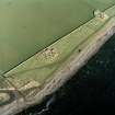
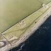
Keiss Broch


Broch (Iron Age)
Site Name Keiss Broch
Classification Broch (Iron Age)
Alternative Name(s) Wic 103; Keiss South
Canmore ID 9318
Site Number ND36SE 2
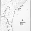
NGR ND 35312 61080
Datum OSGB36 - NGR
Permalink http://canmore.org.uk/site/9318


- Council Highland
- Parish Wick
- Former Region Highland
- Former District Caithness
- Former County Caithness
ND36SE 2 3531 6108.
(ND 3531 6108) Keiss Broch (NR)
OS 1:10,000 map, (1973)
Keiss Broch originated as a 1st phase broch - 1st centuries BC and AD - and was subsequently modified and re-used about the 2nd century AD, and again about the 3rd century AD.
The 2nd century re-occupation involved the blocking of the original seaward-facing entrance and the creation of another on the NE.
The 3rd phase of occupation involved the rebuilding of the outer wall, the blocking of the NE entrance and the re-opening of the original entrance, also the building of an internal scarcement. During this phase, or possibly later, the interior of the broch was divided by slab structures and paved at varying levels, while externally various sprawling enclosures were created.
In 1910, the broch wall survived internally to a height of about 5ft, the height of the scarcement, except on the N where it stood 8ft high. On the exterior the maximum height was 5ft 6ins.
Excavation by Sir Francis Tress Barry produced, among the more usual broch finds, two fragments of 2nd century Samian ware and one sherd of 3rd century Rhenish ware. The finds, which were unstratified, are in the National Museum of Antiquities of Scotland (NMAS).
Feachem (1963) notes the remains of what might have been a primary outwork a short distance to the NE of the broch. Anderson notes the foundations of a large rectangular building a little to the S of the broch. This is probably analagous to those at the 'Road Broch' (ND36SW 1) and 'Whitegate Broch' (ND36SE 3).
J Anderson 1901; RCAHMS 1911, visited 1910; R W Feachem 1963; A Young 1964.
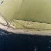
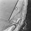
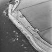
This broch has been severely mutilated, and the seaward entrance is no longer apparent although the entrance on the NE can still be traced. The internal scarcement and the rebuilt outer wall are evident only in the N segment, and the southern gallery can still be traced with a possible cell alongside, together with the remains of several internal structures, the form of which could not be ascertained. The external enclosures are now greatly mutilated. Midden material is evident in an around the walls. No trace could be found of the primary outwork to the NE, mentioned by Feacham. Now in an undulating pasture field. The foundations of the building mentioned by Anderson appear to be relatively modern.
Resurveyed at 1:2500.
Visited by OS (R D) 14 September 1965.
Classification of Roman material.
A S Robertson 1970.
Keiss Broch is as described by the previous field investigator.
Visited by OS (N K B) 22 July 1982.
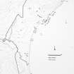
ND 3 6 (area) As part of a wider study of Iron Age Caithness, the broch settlements at Everley (ND 3699 6828), Keiss Harbour (ND 3531 6108), Keiss Road (ND 3488 6151), Whitegate (ND 3541 6120), Skirza (ND 3940 6844), and Hillhead (ND 3762 5140) were recorded by total station survey in June 2000. Aspects of the artefactual assemblage uncovered during 19th-century excavations by Laing and Tress Barry were also studied.
Sponsor: NMS.
A Heald and A Jackson 2000
Field Visit (14 June 1910)
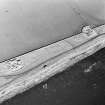
Immediately to the N of the harbour of Keiss, on a beach terrace now overgrown with grass, is the ‘Keiss broch’ or ‘Harbour mound’ (RCAHMS 1911 fig. 39 and pl. LI), which was excavated by the late Sir Francis Tress Barry. The entrance has been from the seaward direction, and, though both sides of the passage are gone, there are remains of the floor of a guard chamber on the right. A well-made drain passes under the flags of the entrance. The interior diameter is 38' [11.6m], and the thickness of the wall about 12' [3.7m]. Against the lower part of the inner face is a lining wall or scarcement 1' 3" thick and still remaining to a height of about 5' on the N., thus reducing the interior diameter to some 35' 6" at floor level. The general average height of wall remaining in the interior is about 5' [1.5m], and the greatest height, which is towards the N, is 8' [2.4m]. At 24' round the inner circumference to the left of the entrance is the entrance, 2' 10" wide, to a stair in the thickness of the wall at a height of 3' 6" above the general floor level. The stair is 2’ 8” wide, but most of the steps are now concealed by the debris. From the level of the entrance to the stair, five steps were discovered on excavation leading down to a water hole, but they are not now visible. The water hole evidently communicated with a well in the interior, irregularly circular, about 4 ½’ in diameter and 6' in depth. Four steps led down to it, and the top was covered by slabs laid level with the floor. On the opposite side of the broch there has been another stairway with a chamber at the foot of the stair, now built up. The stair rose to the right and was 3' 4" wide. The entrance to it had been at one time part of a main entrance through the exterior part of the- wall, but had subsequently been built up and the scarcement built in front of it. On the outside lies a large triangular block of stone which may have formed the lintel of this doorway. The greatest height of wall remaining on the exterior is 5' 6". In the interior are the remains of various small enclosures formed of flags set on end. Immediately outside the closed entrance on the NE. are the remains of an outer wall, and at 16' back from the broch the face of a wall, concentric with the main structure, has been exposed for a distance of some 24' and is visible passing onwards round the building towards the S. The interspace in front of the closed entrance is paved.
Among the relics found on excavation were two fragments of Roman Samian ware; portions of bowls of 2nd-century type, on one of which is an undraped figure of Venus (Dechelette No. 173); two pieces of white ware, covered with a black slip and decorated with a scroll ornament in white, Romano-British manufacture of the 2nd century; a few pieces of coarse unglazed pottery, decorated with an impressed chevrony pattern; a small crucible, 7/8" in depth, with a portion of melted bronze adhering to the bottom; a long-handled bone comb 5 ½” in length; a lamp of sandstone measuring 5 ¼" x 4 ¼ "; a rudely shaped cup of sandstone measuring 4 ½ " x 4 ½ " in length and breadth and 2" in depth; saddle querns and portions of rotary querns; antlers of the red-deer of great size, and bones of the Great Auk. In an earlier excavation a portion of the horn of a reindeer was discovered. The relics are preserved in the National Museum of Antiquities, Edinburgh.
See Proc. Soc. Antiq. Scot., vol. 35 p. 122 (plan and illus.); ibid. vol.7 p. 42 (illus.); ibid. vol.8. p. 192 (illus.).
RCAHMS 1911, visited 14 June 1910.
OS 6” map (1907)
Project (1980 - 1982)
Archaeological Evaluation (July 2006)
A single evaulation trench was excavated across the wall of the Keiss Harbour broch in July 2006. The trench measured 8.75m long by between 1-3m wide, and encompassed both the interior and exterior of the broch. A secondary wall was revealed on the interior. No internal or external surviving in situ deposits were found.
A Duffy 2006

