
Mullardoch Dam


Dam (20th Century)
Site Name Mullardoch Dam
Classification Dam (20th Century)
Alternative Name(s) Mullardoch Reservoir; Affric/beauly Hydroelectric Scheme; Mullardoch-fasnakyle-affric Scheme; Glen Cannich; Glencannich Forest; River Cannich
Canmore ID 81412
Site Number NH23SW 1
NGR NH 22255 31286
Datum OSGB36 - NGR
Permalink http://canmore.org.uk/site/81412


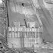
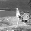
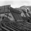
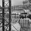
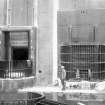
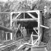
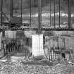
![View from S [from chainage 690 S] of South Wing under construction.
Copy of negative, Mullardoch-Fasnakyle-Affric, Box 873/1, Contract No. 9, Plate No. 125.](http://i.rcahms.gov.uk/canmore/l/SC00869027.jpg)


![View from S [from chainage 690 S] of South Wing under construction.
Copy of negative, Mullardoch-Fasnakyle-Affric, Box 873/1, Contract No. 9, Plate No. 125.](http://i.rcahms.gov.uk/canmore/s/SC00869027.jpg)
- Council Highland
- Parish Kilmorack
- Former Region Highland
- Former District Inverness
- Former County Inverness-shire
NH23SW 1.00 22255 31286
Dam [NAT] (at NH 2221 3129)
OS 1:10,000 map, 1971.
NH23SW 1.01 NH 22990 32112 Cozac Quarry
Location formerly cited as NH c. 219 316 to NH c. 223 310
For associated reservoir (Loch Mullardoch), see NH13SW 6.
For monument (cairn, at NH 21638 31548), presumably associated with the construction of this dam and reservoir, see NH23SW 6.
For associated supply tunnel (to Loch Beinn A' Mheadhoin: NH c. 223 314 to NH c. 248 265), see NH23SW 7.00.
For associated Mullardoch Generating Station (NH 22259 30960), see NH23SW 7.01.
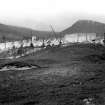
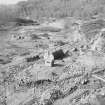
The North of Scotland Hydro-electric Board's plan for Constructional Scheme No. 7 (Mullardoch-Fasnakyle-Affric) was published in Fenruary 1946; there were no objections on fishery or amenity grounds. Labour camps were established at Cannich and Cozac (near Mullardoch).
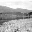
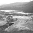
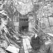
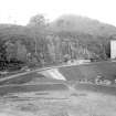
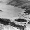
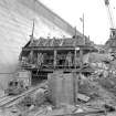
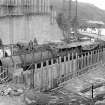
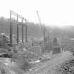
The Mullardoch Dam (at the E end of Loch Mullardoch) was destined to be the Board's largest dam, measuring 2385ft [727.1m] long by 160ft [48.8m] high above itseepest foundations. Its construction required 286,000 cu ft of concrete to impound no less than 7.5 million cu ft of water. An even larger volume of materials would have been required, had it not been possible to build the dam in the form of two wings inclining towards each other and abutting onto an island.
The dam is of mass gravity type, and in late 1949, when the N wing was already well advanced, it was necessary to economise. The option of completing the S wing to a buttress gravity design was rejected on account of the inevitable delays in revising the shuttering and plant layout, with resulting increases in labour and logistic counts. In the event, it was decided in March 1950 to reduce the height of the S wing by 20ft [6.1m]. This was countermanded in February 1951, but the wing was completed to a revised design based on that used for the Mundaring Weir (Australia), which did not require the insertion of steel bonds. The dam was completed in summer 1952, some time after partialimpounding had begun.
P L Payne 1988.
Affric-Cannich scheme, 1952. Mass gravity dam on Loch Mullardoch and tunnel to Loch Benevean. Tunnel from Loch Benevean to to Fasnakyle Power Station (John Cochrane and Sons Ltd). Average annual output: Mullardoch 8 million units, Fasnakyle 223 million units.
J Miller 2002.
This dam spans the upper reaches of the River Cannich, at the E end of Loch Mullardoch (NH13SW 6).
The location assigned to this record defines the approximate midpoint of the structure. The available map evidence indicates that it extends from NH c. 21945 31589 to NH 22239 31362 (bend) to NH c. 22312 31017. The compensation water outflow is at NH 22200 31426.
Information from RCAHMS (RJCM), 12 May 2006.
Publication Account (1988)
The North of Scotland Hydro-electric Board's plan for Constructional Scheme No. 7 (Mullardoch-Fasnakyle-Affric) was published in Fenruary 1946; there were no objections on fishery or amenity grounds. Labour camps were established at Cannich and Cozac (near Mullardoch).
The Mullardoch Dam (at the E end of Loch Mullardoch) was destined to be the Board's largest dam, measuring 2385ft [727.1m] long by 160ft [48.8m] high above itseepest foundations. Its construction required 286,000 cu ft of concrete to impound no less than 7.5 million cu ft of water. An even larger volume of materials would have been required, had it not been possible to build the dam in the form of two wings inclining towards each other and abutting onto an island.
The dam is of mass gravity type, and in late 1949, when the N wing was already well advanced, it was necessary to economise. The option of completing the S wing to a buttress gravity design was rejected on account of the inevitable delays in revising the shuttering and plant layout, with resulting increases in labour and logistic counts. In the event, it was decided in March 1950 to reduce the height of the S wing by 20ft [6.1m]. This was countermanded in February 1951, but the wing was completed to a revised design based on that used for the Mundaring Weir (Australia), which did not require the insertion of steel bonds. The dam was completed in summer 1952, some time after partialimpounding had begun.
P L Payne 1988.
Publication Account (2007)
In 1928 and 1941 hydro-schemes were proposed in Glen Affric. The first was turned down by Parliament and the second was dropped in favour of the more comprehensive Mullardoch–Fasnakyle–Affric project which was approved in 1947 and officially opened in 1952. A further stage to the north, developing the water power resources of the Beauly and its tributaries, the Strathfarrar and Kilmorack scheme, was carried out from 1957–63 and included the impressive 113 ft high double curvature arch dam at Loch Monar.
The main elements of the Affric scheme consist of Mullardoch Dam (NH23SW 1.00), a tunnel from Loch Mullardoch to Benevean, a small dam at Loch Benevean (NH22NE 5.01) and a tunnel from there to the main generating station at Fasnakyle in Strathglass (NH32NW 4.00).
Mullardoch Dam is 157 ft high and 2385 ft long and, with about 300 000 cu. yards of concrete, is the largest concrete gravity dam in Great Britain. It has two wings meeting at an angle of 1408 with the apex pointing downstream. Construction began in 1947 and two years into the work it was decided to raise the height of the dam by 20 ft, a change requiring great skill in its execution.
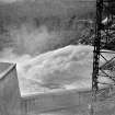
The dam has two spillways each 315 ft long and the level of the loch was raised by 112 ft to form a reservoir 8 1/2 miles long. Water from the reservoir is conveyed through a 14 1/2 ft diameter tunnel, 3 miles long, to Loch Benevean and onward to Fasnakyle Power Station where three 22 000kW
turbo alternators, with Francis-type turbines working under a gross head of about 520 ft, each develop 33 000 hp at 375 rpm.
The engineers were Sir William Halcrow & Partners and the main contractors, John Cochrane & Sons.
R Paxton and J Shipway, 2007.
Reproduced from 'Civil Engineering heritage: Scotland - Highlands and Islands' with kind permission from Thomas Telford Publishers.
Field Visit (2010)
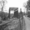
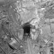
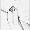
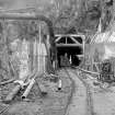
This large arrowhead dam controls the outflow of Loch Mullardoch and diverts water via a small underground power station directly adjacent to the upstream side of the dam wall through to Loch Bennevean (see separate item). The dam is 727 meters long and 48 meters high forming an imposing curtain wall across the upper reaches of the glen. The arrowhead form is relatively unusual with the large central buttress housing a compensation set and control gates. Mullardoch dam is the largest built under the auspices of NoSHEB and occupies a dominant setting at the top of the glen. The inclusion of a small power station operating on the flow through to the slightly lower Loch Bein a Mhedoin is a good example of the determination on the part of the board that schemes be designed for maximum efficiency. The station is unique in Scotland as an underground station with only a vertical shaft for access as the turbine hall lies beneath water level in the loch. Mullardoch forms the main storage component for Fasnakyle despite lying in a separate catchment. This is a response to the worries about the impact on scenic amenity in the area as large fluctuations in the level of Bein a Mhedoin were seen as being harmful to the scenery of upper Glen Affric. National Archives of Scotland (NAS), Ref: NSE North of Scotland Hydro Electric Board Collection (1943 -1990); NAS, Ref: NSE1 North of Scotland Hydro Electric Board Minutes (1943-1990); NAS, Ref NSE2 North of Scotland Hydro Electric Board Annual Reports (1943-1990); PL Payne, 1988; J Miller, 2002, 52: E Wood, 2002, 87,88; Scottish Hydro Electric, 2000, 12.
Note (25 October 2023)
The Affric/ Beauly scheme
The work was begun on the construction of Mullardoch Dam in 1947. This is of the mass gravity type and is 2385 feet in length by 160 feet in height, impounding 7.5 million cubic feet of water. A tunnel was excavated from Loch Mullardoch to Loch Benevan, and another from the latter loch to Fasnakyle, the main power station on the River Affric, both tunnels being over three miles in length. The Fasnakyle tunnel splits into three steel-lined tunnels near the power station, each supplying a 22,000kW vertical Francis turbo-alternator.
The second stage of the scheme involved the Rivers Farrar and Beauly. Water is impounded in Loch Monar by the Monar Dam, supplying the Deanie power station at the west end of Loch Bennacharan which is dammed at the east end to feed Culligran power station, whose outflow to the River Farrar then flows into the River Glass. These power stations generate 38MW and 24MW respectively. The River Glass flows into the River Beauly which has dams and power stations at Aigas and Kilmorack, each a 20MW run of river station. These dams are provided with flood control, Borland fish passes and compensation water facilities with or without generation. The scheme was completed in 1963.
Information from NRHE, catalogue item number WP007424 compiled by George Walker, 2005.

