Accessibility

Font Size

100% 150% 200%

Background Colour

Default Contrast
Close Reset

Invergordon, Aluminium Smelter, Saltburn Pier

Jetty (Period Unassigned)

Site Name Invergordon, Aluminium Smelter, Saltburn Pier

Classification Jetty (Period Unassigned)

Alternative Name(s) Cromarty Firth; Firth Of Cromarty; Invergordon, Aluminium Smelter, Jetty; Invergordon, Aluminium Works, Pier; British Alcan Pier

Canmore ID 75542

Site Number NH76NW 30

NGR NH 7260 6846

NGR Description NH 7260 6846 to NH c. 7212 6932

Datum OSGB36 - NGR

Permalink http://canmore.org.uk/site/75542

Ordnance Survey licence number AC0000807262. All rights reserved.
Canmore Disclaimer. © Bluesky International Limited 2025. Public Sector Viewing Terms

Toggle Aerial | View on large map

Digital Images

Distant view from north
Distant view from northGeneral view from northAerial view of Invergordon, Cromarty Firth, looking N.An oblique aerial view of the Cromarty Firth, looking SW.Aerial view of Cromarty Firth & Invergordon, looking NE.Aerial view of Saltburn Pier, Invergordon, Easter Ross, looking SE.Aerial view of Invergordon County Community Hospital, looking NW.An oblique aerial view of Invergordon, Easter Ross, looking E.An oblique aerial view of Invergordon, Easter Ross, looking E.Oblique aerial viewOblique aerial view.Aerial view of Invergordon Saltburn pier, Cromarty Firth, looking N.Aerial view of Invergordon, Cromarty Firth, looking N.Aerial view of Invergordon and the Cromarty Firth, looking W.Oblique aerial view of Invergordon, looking S.An oblique aerial view of the Cromarty Firth, looking WSW.Oblique aerial viewOblique aerial view of Saltburn Pier and Saltburn, Invergordon, looking NE.An oblique aerial view of Invergordon, Ross and Cromarty, looking S.Oblique view of Invergordon and the oil storage tanks, looking across the Cromarty Firth to the Black Isle, looking S.Aerial viewAerial view of Invergordon and the Cromarty Firth, looking W.An oblique aerial view of Invergordon, Ross and Cromarty, looking S.Aerial view of Oil Storage Tanks, Invergordon, Easter Ross, looking S.An oblique aerial view of Invergordon, Easter Ross, looking NE.View from northAerial view of Cromarty Firth, looking NE.Aerial view of Invergordon, Easter Ross, looking E.Aerial view of Invergordon, Cromarty Firth, looking N.Aerial view of Invergordon and the Cromarty Firth, looking W.Aerial view of Invergordon and the Cromarty Firth under snow, looking WSW.Aerial view of Cromarty Firth & Invergordon, looking ENE.

Administrative Areas

  • Council Highland
  • Parish Rosskeen
  • Former Region Highland
  • Former District Ross And Cromarty
  • Former County Ross And Cromarty

Archaeology Notes

NH76NW 30 7260 6846 to c. 7212 6932

Pier [name: NH 723 688]

Conveyor [name: NH 721 692]

OS 1:10,000 map, 1991.

For (associated) aluminium smelting works, see NH77SW 24.

Jetty for aluminium works.

In use - Stable condition.

CFA/MORA Coastal Assessment Survey 1998.

Charted as British Alcan Pier: UKHO chart no. 1889 (1975, revised 1990).

Information from RCAHMS (RJCM), 18 October 2011.

Saltburn Pier [NAT]

OS (GIS) MasterMap, October 2011.

Activities

Field Visit (2015)

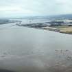
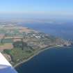
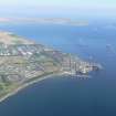
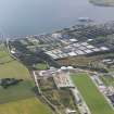
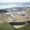
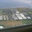
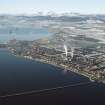
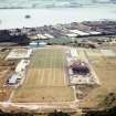
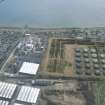
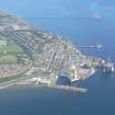
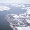
This pier was built to allow movement of raw materials and finished product to and from the now demolished Invergordon Aluminium Smelter which closed in 1981. A conveyor that was connected to the pier from the smelter survived until c.1986. The pier is some 1.0km in length, exploiting the deep water in the Cromarty Firth. At its loading end it has a travelling hopper and crane and two fixed green light beacons.

Visited by HES (MMD), 12 Octpber 2015

References

MyCanmore Image Contributions


Contribute an Image

MyCanmore Text Contributions