Wauchope, Old Parish Church
Architectural Fragment(S) (Medieval), Burial Ground (Medieval) - (18th Century), Church (Medieval) - (18th Century), Cross Slab(S) (Early Medieval), Grave Slab (Medieval) - (18th Century)
Site Name Wauchope, Old Parish Church
Classification Architectural Fragment(S) (Medieval), Burial Ground (Medieval) - (18th Century), Church (Medieval) - (18th Century), Cross Slab(S) (Early Medieval), Grave Slab (Medieval) - (18th Century)
Alternative Name(s) Wauchope Churchyard; Langholm, Wauchope Burial-ground
Canmore ID 67662
Site Number NY38SE 2
NGR NY 35524 84082
NGR Description NY 35524 84082
Datum OSGB36 - NGR
Permalink http://canmore.org.uk/site/67662
- Council Dumfries And Galloway
- Parish Langholm
- Former Region Dumfries And Galloway
- Former District Annandale And Eskdale
- Former County Dumfries-shire
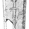
Wauchope, Dumfriesshire, cross-slab
Measurements: H 0.58m, W 0.43m, D 0.57m
Stone type:
Place of discovery: NY 3552 8408
Present location: within a railed enclosure at Wauchope.
Evidence for discovery: known since the late 19th century, the stone was placed on top of the grass-grown remains of the church within a railed enclosure in 1913.
Present condition: good.
Description
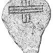
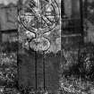
A block-like slab bearing an outline cross in false relief, with slightly wedge-shaped arms, traces of a central boss and a short tang at the base of the shaft.
Date: early medieval or later.
References: RCAHMS 1997, no 1799, 256.
Desk-based information compiled by A Ritchie 2019
NY38SE 2 35524 84082.
(NY 3556 8415) Wauchope Church (NR) (Remains of)
OS 6" map (1957).
See also NY38SE 88.
Part of the foundation of the S wall of Wauchope parish church remains within a railed enclosure in the churchyard. About it are placed several moulded or splayed stones of doors or windows, incised cross-slabs and grave slabs.
The church, which belonged to Canonbie Priory, is mentioned in 1220. It was demolished after the union of Wauchope parish with Staplegorton and half of Morton to form Langholm parish (NY38SE 4) in 1703.
RCAHMS 1920, visited 1920.
G Chalmers 1890; J and R Hyslop 1912
Wauchope (Glasgow, Eskdale). Both parsonage and vicarage revenues had been annexed to Jedburgh by 1220 in which year it was agreed that the vicar should receive five marks per annum. These revenues continued to be annexed to the abbey at the Reformation, being then utilised, as they no doubt always had been, for the support of the dependent cell of Canonbie, while the cure evidently continued to be pensionary.
I B Cowan 1967.
(Location cited as NY 354 840; listed 3 August 1971 as Wauchope churchyard). L-plan churchyard enclosed by rubble-built red ashlar-coped walls; 2 concrete gatepiers at N; steep gully at unwalled S side above Wauchope Water. 18th and 19th century headstones and site of Wauchope Church. Many 18th century stones have good artisan sculpture; some large 19th century mural monuments, particularly along E wall.
The parishes of Staplegordon and Wauchope were united in 1703 to form that of Langholm.
SDD List, 1988.
OSA 1791-9.
Field Visit (29 September 1979)
The railed enclosure which is 2.7m by 1.5m stands at NY 3552 8409. The foundations cannot be identified on the ground because they are turf-covered and overlaid by the various incised and moulded stones. A plaque states that the relics of the kirk were collected and arranged by the Eskdale and Liddesdale Archaeological Society in 1913.
Railed enclosure surveyed at 1:2500.
Visited by OS (MJF) 29 September 1979
Field Visit (March 1981)
Wauchope, Old Parish Church and Burial-ground NY 355 840 NY38SE 2
This church is on record in the 13th century, but 'was demolished' after the suppression of the parish of Wauchope in 1703, and only a fragment of the foundation of the S wall now remains. Three medieval graveslabs, a stone bearing an incised cross (possibly of Early Christian date) and a number of fragments of moulded stones have been removed from the burial-ground to Langholm Town Hall.
RCAHMS 1981, visited March 1981
(Armstrong 1883, 106-8; Chalmers 1887-1902, v, 200-1; Hyslop and Hyslop 1912, 456-63; RCAHMS 1920, p. 148, Nos. 438,439; Cowan 1967, 207)
Field Visit (30 June 1993)
NY38SE 2 NY 3552 8409
Five medieval grave-slabs and several architectural fragments from the burial-ground at Wauchope (NY38SE 2) are held in store at the Cleansing Dept. yard in Langholm (NY 3619 8466). They are listed as follows:
1. A grave-slab (0.58m by up to 0.43m and 0.57m thick), possibly of Early Christian date and bearing the outline of a Latin cross in false relief, with arms which are slightly wedge-shaped, slight traces of a central boss and a tang at the base of the shaft.
2. A grave-slab (0.92m by up to 0.35m and up to 0.23m thick) with chamfered edges, bearing the incised outline of a sword with depressed quillons.
3. A fragment of a grave-slab (0.73m by 0.3m by and 0.13m thick) bearing the incised outline of a ringed cross. The shaft has an orb beneath the cross and probably originally terminated in a stepped base, but this portion of the cross is now missing.
4. A fragment of a grave-slab (0.42m by 0.38m and 0.15m thick) which has been re-used. It bears a ring in false relief and the incised outline of a cross with wedge-shaped arms. The top edge of the slab has a chamfered arris and the chamfers on the long sides of the slab have been cut away by rebates.
5. A grave-slab (0.92m by up to 0.35m) with chamfered edges, bearing the incised outline of a sword with depressed quillons.
6. A slab moulded with a check and two half rounds.
7. A fragment of 'Y' tracery (0.35m by 0.25m and up to 0.24m thick). The top of the block bears the deeply-wrought initials in Roman capitals 'III'.
8. A fragment of tracery with a square upstand and chamfered arris (0.5m by 0.2m and 0.22m thick).
9. A fragment of a mullion with deeply-chamfered edges on one side and an upstand with chamfered arrises on the otyer (measuring 0.27m high by 0.23m long and 0.19m thick). See also no. 13, below.
10. A voussoir, checked (with a fillet emerging from the check) and chamfered (0.33m by 0.23m and 0.14m thick).
11. A voussoir of a window bearing the upstand for a mullion and transoms (0.34m by 0.23m).
12. A window mullion with deeply-chamfered edges and, to the rear, a checked and chamfered upstand. The mullion is wrought with a socket for a saddle bar.
13. A fragment of an 18th-century grave-slab bearing, in the tympanum, a winged soul.
14. Two balusters from a table tomb.
Visited by RCAHMS (IMS), 30 June 1993.
Listed as church, burial-ground, Early Christian cross-slab, medieval graveslabs and architectural fragments.
RCAHMS 1997


