
Learable Hill


Cairnfield (Prehistoric), Enclosure (Period Unknown), Field System(S) (Prehistoric), Hut Circle(S) (Prehistoric)
Site Name Learable Hill
Classification Cairnfield (Prehistoric), Enclosure (Period Unknown), Field System(S) (Prehistoric), Hut Circle(S) (Prehistoric)
Canmore ID 6705
Site Number NC82SE 16
NGR NC 889 234
Datum OSGB36 - NGR
Permalink http://canmore.org.uk/site/6705


- Council Highland
- Parish Kildonan
- Former Region Highland
- Former District Sutherland
- Former County Sutherland
Field Visit (20 January 1977)
NC82SE 16 889 234.
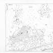
Centred at NC 889 234 is a settlement of three hut circles ('A' - 'C') and an associated minor field system of approximately 9-10 hectares situated above the Allt Leitir nan Caile. 'A' is 11.5m in diameter within a low wall, heather-covered except for a short stretch of bare stones in the SE, possibly exposed slumped walling or field clearance. The wall was about 1.5m wide with the entrance in the SW. 'B' appears as a platform set into the S-facing slope and measures 13.0m E-W by 11.0m within the fragmentary remains of a wall. The entrance is in the E.
'C' is visible as an ill-defined platform measuring about 9.0m E-W by 8.0m within the slumped remains of a wall. The entrance is in the E. The field system is defined by clearance heaps and lynchets. Plots are discernible in the SW section of the system; one immediately to the S of 'A' measures approximately 20 x 20m, another 40m x 20m. Further up the hill on more level ground, lynchets are not easily recognized.
Survey at 1/10,000.
Visited by OS (J B) 20 January 1977
Field Visit (6 June 1991)
An area of small cairns extends over a distance of 650m from E to W by at least 300m transversely on the SE spur of Learable Hill to the W of Learable township and encompassing within it the associated monuments described elsewhere: a standing stone (NC82SE 1); a stone circle (NC82SE 4); several stone rows (NC82SE 6); and a cairn (NC82SE 9), all of which are concentrated in a small area around the brow of the spur. The four hut-circles are situated on the S slope of the spur, overlooking the Allt Leitir nan Caile, whilst the enclosure lies on the S lee of the spur some 100m W of the stone circle.
Amongst the small cairns there are several curvilinear clearance dykes, terraces and rickles of stones, of which one of the latter runs along the S edge of the spur above a steeply falling slope for about 140m from NC 8906 2346 to NC 8920 2343. Some 40m to the NW there is a sub-rectangular enclosure with rounded corners at the W end and squared corners at the E end, which measures 29m from WNW to ESE by 23m transversely within heather-covered banks up to 0.4m in height. It is sub-divided into two unequal parts by a bank, which runs across it from NNE to SSW, and the larger E compartment shows traces of a terrace. (KILD91 417)
A. NC 8898 2343 This hut-circle is situated on a natural terrace on the lower slopes of the hill and measures 10m in diameter within a stony bank spread to 1.6m in thickness and 0.4m in height, but with no entrance visible.
(KILD91 202)
B. NC 8883 2340 This hut-circle, which is situated some 175m W of 'A', is terraced into a steep slope and measures 10.5m in diameter within a bank spread to 2.7m in thickness and 0.8m in height and an entrance on the ESE. On the SE and SW the bank incorporates what may be natural mounds.
(KILD91 203)
C. NC 8884 2348 This hut-circle is situated in gently sloping ground towards the top of the slope some 80m N of 'B' and measures 11m in diameter within a stony bank spread to 2.2m in thickness and 0.4m in height with what may be inner and outer facing-stones. The position of the entrance is uncertain, but it may be indicated by a dip in the bank on the SW.
(KILD91 204)
D. NC 8904 2342 What may be a hut-circle is set into the slope at the back of a natural terrace, some 50m NE of 'A'. It comprises an oval platform, which measures 8m from E to W by 7.3m transversely, and has some stones visible on its downslope or S side. A bank runs upslope from its E side and describes a semi-circle around the top edge of the terrace.
(KILD91 416)
Visited by RCAHMS (PJD) 6 June 1991

