|
Prints and Drawings |
DC 25001 PO |
Records of the Royal Commission on the Ancient and Historical Monuments of Scotland (RCAHMS), Edinbu |
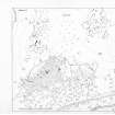
Distribution map of hut-circles in the Strath of Kildonan |
1992 |
Item Level |
|
|
Prints and Drawings |
DC 25002 PO |
Records of the Royal Commission on the Ancient and Historical Monuments of Scotland (RCAHMS), Edinbu |
Distribution map of hut-circles in the Strath of Kildonan |
1992 |
Item Level |
|
|
Manuscripts |
MS 731/1 |
Records of the Royal Commission on the Ancient and Historical Monuments of Scotland (RCAHMS), Edinbu |
Printed and bound copies of the RCAHMSALS Field Survey Database entries (1-479), Strath of Kildonan |
1991 |
Item Level |
|
|
Prints and Drawings |
DC 21610 |
Records of the Royal Commission on the Ancient and Historical Monuments of Scotland (RCAHMS), Edinbu |
Plan of archaeological landscape |
1991 |
Item Level |
|
 |
On-line Digital Images |
DP 054966 |
Records of the Royal Commission on the Ancient and Historical Monuments of Scotland (RCAHMS), Edinbu |
Publication drawing; plan of archaeological landscape at Learable |
6/1991 |
Item Level |
|
|
Digital Files (Non-image) |
DX 001419 |
Records of the Royal Commission on the Ancient and Historical Monuments of Scotland (RCAHMS), Edinbu |
RCAHMS Structures Database, Strath of Kildonan |
1991 |
Item Level |
|
 |
On-line Digital Images |
SC 2349963 |
Records of the Ordnance Survey, Southampton, Hampshire, England |
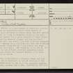
Learable Hill, NC82SE 16, Ordnance Survey index card, page number 1, Recto |
1958 |
Item Level |
|
 |
On-line Digital Images |
SC 2349964 |
Records of the Ordnance Survey, Southampton, Hampshire, England |
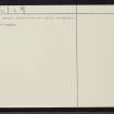
Learable Hill, NC82SE 16, Ordnance Survey index card, page number 2, Verso |
1958 |
Item Level |
|
|
All Other |
551 166/1/1 |
Records of the Ordnance Survey, Southampton, Hampshire, England |
Archaeological site card index ('495' cards) |
1947 |
Sub-Group Level |
|


