
Dumfries, Old Bridge


Road Bridge (15th Century)
Site Name Dumfries, Old Bridge
Classification Road Bridge (15th Century)
Alternative Name(s) Whitesands; Mill Road; Devorguilla's Bridge; Devorgilla Bridge; River Nith
Canmore ID 65555
Site Number NX97NE 26
NGR NX 96890 76053
Datum OSGB36 - NGR
Permalink http://canmore.org.uk/site/65555


- Council Dumfries And Galloway
- Parish Dumfries
- Former Region Dumfries And Galloway
- Former District Nithsdale
- Former County Dumfries-shire
NX97NE 26.00 96890 76053
NX97NE 26.01 NX 9688 7604 Gateway
NX97NE 26.02 NX 96855 76013 Old Bridge House (Museum)
(NX 9688 7604) Old Bridge (NR)
OS 6" map (1970)
EXTERNAL REFERENCE:
Scottish National Portrait Gallery:
SMT Magazine, May 1951 - article and photograph
Country Life Magazine, August 1st 1947 - article and photograph
National Library:
Earnock MSS. 1. No. 43 - 1 engraving
Country Life Magazine, July 1943 - article and photograph
(Undated) information in NMRS.
A bridge - probably wooden - is said to have been built across the Nith at Dumfries by Devorgilla Balliol some time in the 1260's. A document of 1431/2 refers to 'the bridge which has recently begun' at Dumfries. This structure was swept away by a flood in 1621.
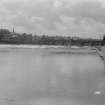
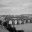
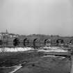
This rebuilt 17th century bridge originally had nine arches, but on the reclamation of the eastern bank of river early in the 19th century the three eastern arches were removed, leaving the remaining six arches spanning a width of 163 ft. A corbel on the N side of the eastmost arch is dated 1610, but this stone was taken from a house being reconstructed late in the 19th century and inserted in the bridge.
The bridge is in good repair, and in use for pedestrian traffic.
SBS Dumfries 1977; G W Shirley 1915; RCAHMS 1920, visited 1912
This bridge is as described and illustrated.
Visited by OS (JLD) 8 December 1960.
(Location cited as NX 969 760). Devorgilla's Bridge, built 1432, east half rebuilt 1620, and 3 spans demolished 1794. A 6-span masonry bridge with dressed-stone arch rings and rubble spandrels. There are prominent triangular cutwaters, the central ones carried up to form pedestrian refuges. The arches are semicircular. The westmost arch is reckoned to be original. Now a footbridge only.
J R Hume 1976.
Old Bridge, from Whitesands to Mill Road. Built c. 1430-2 and reconstructed in 1620 after being wrecked by a flood; shortened from 9 arches to 6 in the early 19th century.
J Gifford 1996.
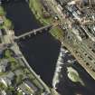
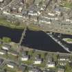
This bridge carries a footpath across the River Nith to the N of the weir (caul) NX97NE 122, and on the W side of the central area of Dumfries (NX97NE 98). The river here forms the boundary between the parishes of Troqueer (to the W) and Dumfries (to the E).
The location assigned to this record defines the mispoint of the structure. The available map evidence suggests that it extends from NX c. 96857 76017 to NX c. 96910 76078.
Information from RCAHMS (RJCM), 17 March 2006.
Photographic Survey (1900 - 1930)
Photographs by A Brown & Co of sites across Scotland c1900-1930
Photographic Survey (October 1964)
Photographic survey by the Scottish National Buildings Record/Ministry of Work in October 1964.
Publication Account (1977)
Edgar was the first writer to assign the building of a bridge across the Nith to Dervorgilla de Balliol whom he identifies incorrectly as 'Dornagildfl.i a spouse to John Balliol' (Reid, 1915, 53). That tradition has stuck and it is perhaps not unreasonable to suspect that .she might have funded such a project. On 16th January 1425 /6 the Countess of Galloway granted a charter to the Dumfries Greyfriars which enabled them to collect a toll levied at the bridge (Reid, 1915, !'50). Even more significant is the wording of a 1431/2 papal relaxation which speaks of 'the bridge which has recently begun', at Dumfries over the River Nith (Shirley, 1915, 27). So a stone bridge was wilt at Dumfries at least by the first half of the fifteenth century, a structure which was swept away by a flood in 1621. The rebuilt seventeenth-century bridge originally had nine arches, three of which were later removed. It is in good repair and is still in daily use for pedestrian traffic. The building of that bridge had provided not only greater access to Dumfries markets, but had led to the creation of a suburban area - Newtown - under the 'west barnraws'. A second bridge was constructed just upriver from the original in the 1790s to aid the increased flow of traffic. Its construction similarly had a revolutionary effect on the character of the northern end of Dumfries.
Information from ‘Historic Dumfries: The Archaeological Implications of Development’ (1977).
Publication Account (1986)
With its six arches and solid piers built in local red sandstone the old bridge over the Nith at Dumfries is a picturesque and memorable sight; it is also the oldest surviving multiple-arched stone bridge in Scotland, second only to the single-arched Bridge of Balgownie at Aberdeen in point of antiquity. Known as Dervorguilla Bridge, it has obviously inherited the name of its late 13th century, and probably timberbuilt predecessor. However, its construction was funded, not by the munifIcent Dervorguilla de Balliol but by the Douglases and the Burgh of Dumfries, and building work is known to have been in progress in 1431. The bridge was half wrecked by floods in 1620, and evidence of rebuilding can be detected in the eastern half of the structure. In fact, the bridge had no less than nine arches until the early 19th century when it lost its three easternmost arches and became restricted to foot traffIc, hence the somewhat abrupt stepped approach. With its 3.9m-wide carriageway and its arched toll-gate (removed in 1769), the old bridge had been equal to the demands of medieval wheeled traffic in and out of Galloway, but by the late 18th century its retirement had become long overdue.
The new bridge was a five-arched structure designed by Thomas Boyd, a local architect (see no. 21). The construction of the bridge involved an elaborate ramped approach along what is now Buccleuch Street, and problems were encountered in the laying of foundations on that bank. The bridge was finally completed in 1794, and almost exactly a century later, in 1893, it was widened and had pedestrian paths cantilevered out. Since then it has undergone two major overhauls, and now shares the town's considerable traffic load with St Michael's Bridge (1927) downstream.
Information from ‘Exploring Scotland’s Heritage: Dumfries and Galloway’, (1986).
Publication Account (2007)
This historic bridge over the Nith built for Devorgilla, mother of John Baliol, one of the oldest in Scotland, originally dated from the mid 15th century, a date of ca.1431 has been mooted. Its width between parapets is 14 ft. The bridge originally had nine masonry arches of irregular spans and rises.
In 1619 the five arches on the west side were carried away in a flood, but rebuilt within a year; a tremendous
undertaking at a time when it was more usual to build one span each year and reuse the centring. In 1725 Gilbert Smith rebuilt the parapets. In 1828 the three arches at the eastern end of the bridge were removed. It is now used as a public footbridge. Very little of the bridge now dates from before 1620.
R Paxton and J Shipway 2007
Reproduced from 'Civil Engineering heritage: Scotland - Lowlands and Borders' with kind permission from Thomas Telford Publishers.

