
Following the launch of trove.scot in February 2025 we are now planning the retiral of some of our webservices. Canmore will be switched off on 24th June 2025. Information about the closure can be found on the HES website: Retiral of HES web services | Historic Environment Scotland
Edinburgh, Holyrood Park, Arthur's Seat, Samson's Ribs


Fort (Period Unassigned), Intaglio (Onyx )(Roman) (-27)-(14)
Site Name Edinburgh, Holyrood Park, Arthur's Seat, Samson's Ribs
Classification Fort (Period Unassigned), Intaglio (Onyx )(Roman) (-27)-(14)
Alternative Name(s) Queen's Park
Canmore ID 52121
Site Number NT27SE 118
NGR NT 27450 72492
Datum OSGB36 - NGR
Permalink http://canmore.org.uk/site/52121


- Council Edinburgh, City Of
- Parish Edinburgh (Edinburgh, City Of)
- Former Region Lothian
- Former District City Of Edinburgh
- Former County Midlothian
NT27SE 118 2745 7250.
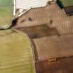
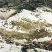
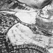
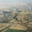
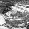
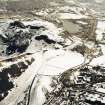
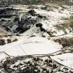
NT 2745 7250.There are the slight remains of a fort on Samson's Ribs, a narrow rocky ridge sloping precipitiously to S and W, and overlooked by Nether Hill from which it is separated by a narrow gully.
It measures 130m E-W by a maximum of 40m transversely, and is enclosed by a severely reduced stone rampart of which a few outer facing stones survive together with a thin scatter of core stones. No inner facing stones remain to allow the width to be determined. The entrance is marked by a slight hollow through rock outcrops on the W where an annexe some 40m NW-SE by 30m transversely, provided an additional defence covering the easiest approach.
The interior contains two circular house-platforms, each about 7.0m in diameter, and apparently stone walled. The presence of stone walled huts raises the possibility that two phases of occupation are represented, a fort and later settlement.
In 1969 a fine intaglio-sadonyx (? idealized bust of Alexander the Great), set in the remains of an iron ring, was found by a boy under a stone which may have been part of a structure in the interior of the fort. It belongs perhaps to the 1st century BC, but was presumably lost after 80 AD.
Surveyed at 1/2500.
Visited by OS (R D) 14 December 1970; Information contained in letter from R B K Stevenson, NMAS, to OS 29 December 1969.
Ring donated to NMAS by Queen's and Lord Treasurer's Remembrancer in 1969.
NMAS 1970.
This fort and settlement is as described by previous field report.
Visited by OS (S F S) 2 December 1975.
Condition Survey (February 1996)
Field survey confirmed the previous site description, stating that the remains are very indistinct. The depth of the soil across the site varies but never appears to be very great. A small amount of erosion has occurred by people walking across the ramparts and down to the Queen’s Drive.
Information from Derek Alexander (Centre for Field Archaeology, University of Edinburgh) February 1997, no.18
Alexander 1997
Field Visit (15 December 1998)
This fort occupies the top of the narrow rocky ridge above Samson's Ribs and is defended around the northern half, where the ridge is most accessible, by a single stone rampart. Elsewhere, the ridge drops precipitously and there are no visible traces of any man-made defences. On the NE, below the crest of the ridge, stretches of the outer face of the rampart still survive formed by large boulders, and in some places standing two courses in height. Along the crest of the ridge, the rubble core of the rampart can be followed as a spread of smaller stones 1.5m thick. A cleft between two outcrops indicates the position of the entrance on the NW, and leads from an external annexe on this end of the ridge into the interior. The annexe is also enclosed by a stone rampart, which can be followed along the N side but is lost on the rocky slope forming the S side of the crag; the entrance to the annexe is on the NW. Within the SE corner of the annexe, the stone footings of a wall extend for about 14m, but its date and function are uncertain. Only one possible structure is visible in the fort, and this comprises little more than an arc of stones on the S and a shallow scarp at the base of rock outcrop on the N. These features are all plotted at 1:5,550 on an archaeological map of Holyrood Park (RCAHMS 1999).
Visited by RCAHMS (ARG), 15 December 1998.
NMRS, MS/726/96 (42-3, no. 18); RCAHMS 1999.
Watching Brief (18 August 2005 - 19 August 2005)
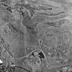
A watching brief was undertaken in Holyrood Park over a period of three days while contractors excavated a trench along the S side of the road between Pollock Halls and Duddingston Village at a point known as Samson’s Ribs (Fig. 1). The purpose of the exercise was to locate and repair a break in a mains electricity cable.
The work would involve digging down to the break and then excavating along the length of the cable for a distance of 10m each side of the repair point, producing a trench not less than 20m in length. Service plans of the area suggest that a total of nine cables may lie below the S footpath of the roadway. At least half of the cables were believed to be 11 kV or 30 kV, which necessitated considerable care and attention in the machine excavation of the trench.
The area under investigation lies over the S end of the Innocent Tunnel with the probability that the deeper deposits in this area are derived from that period of construction work. Additionally the cables in this area of the park are known to have been put in place in 1946 resulting in complete disturbance of the upper levels within the present work zone.
The area of work is the site of massive landscaping work associated with the cutting of the coal yard railway tunnel and the creation of the park road running across it. The site of these excavations was on the edge of this substantial disturbance.
The cable trench opened in the present works simply followed the line of the 1946 cable insertions. All deposits are therefore redeposited Victorian landscaping dumps. The damage to the power cable seemed likely to have been caused by the presence of the concrete slab F107 bending and distorting the cable.
G Ewart 2005
Sponsor: Historic Scotland
Kirkdale Archaeology
Note (10 November 2015 - 2 September 2016)
This fort is situated on an elongated hillock low down on the SW flank of Arthurs Seat, immediately S of the road leading round past Dunsapie Loch. The road here lies in a gully forming the N flank of the hillock, which elsewhere on the S and SW falls away in cliffs. The N flank, is thus relatively easy of access and has been defended by a single rampart drawn along its lip from the E tip to return across the outcrops to the cliff-edge on the W; stretches of outer face can be seen towards the E end, while a cleft in the outcrops on the WNW probably marks the position of the entrance, leading out into an outer enclosure or annexe extending down the slope on the WNW. The rocky interior of the inner enclosure measures about 95m from ESE to WNW by up to 45m transversely (0.43), while the outer enclosure measures about 40m by 25m respectively within its rampart and has an entrance on the WNW. Within the inner enclosure there are traces of at least one possible round-house, comprising a shallow scoop at the foot of an outcrop on one side and a stony bank on the other. A wall some 14m in length recorded by Robert Stevenson (1970, 293, fig 4) at the SE end of the annexe appears to be of later date rather than an element of the defences.
Information from An Atlas of Hillforts of Great Britain and Ireland – 02 September 2016. Atlas of Hillforts SC3720
Condition Survey (12 March 2018 - 15 April 2018)
The 2018 CFA Archaeology Ltd condition survey found the site as previously described: that the remains are very discrete and difficult to see and interpret.
Information from Graeme Carruthers (CFA Archaeology Ltd) July 2018. OASIS ID: cfaarcha1-317194, no.18

