
Dundee, Stannergate Road, Hms Condor Ii, Seaplane Base


Seaplane Base (Second World War), Seaplane Base (First World War)
Site Name Dundee, Stannergate Road, Hms Condor Ii, Seaplane Base
Classification Seaplane Base (Second World War), Seaplane Base (First World War)
Alternative Name(s) Caledon East Wharf; Prince Charles Wharf; Flying-boat Hangar
Canmore ID 33551
Site Number NO43SW 88
NGR NO 4316 3091
NGR Description Centred NO 4316 3091
Datum OSGB36 - NGR
Permalink http://canmore.org.uk/site/33551


- Council Dundee, City Of
- Parish Dundee (Dundee, City Of)
- Former Region Tayside
- Former District City Of Dundee
- Former County Angus
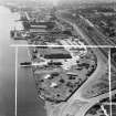
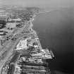
Dundee, Stannergate military seaplane station saw longer service in the 20th century than any other seaplane base in Scotland. It was established prior to the beginning of the First World War, in the spring of 1914; the seaplanes (and possibly even one of the seaplane sheds) of the short-lived Port Laing (Rosyth) seaplane station in the Firth of Forth were transferred to Dundee. The seaplanes at the base undertook patrols and anti-submarine operations in the North Sea. At the end of 1916 eight Short Admiralty seaplanes were based at Stannergate.
The station occupied two adjacent sites. On the shore the seaplane sheds and technical buildings occupied an area of about 6 hectares, with two slipways. The station was initially equipped with two seaplane sheds, but by the time of the RAF survey of air stations of 1918 there were four. The accommodation for the station’s personnel lay in the second site, extending to about 2.6 hectares, to the north of the main railway line.
In 1918 the station also acted as an ‘acceptance station’ to which new seaplanes were delivered by their manufacturers for testing. The station had been run down by 1920, when the site was sold off.
The Stannergate seaplane station was re-established in the spring of 1940, closing again in 1944. Three of the First World War hangars are mapped on the 1940 1:2500 OS map; the easternmost had disappeared. Buildings of the base survived until the final part of the 20th century, but nothing is now visible. The area of water between the two slipways has been reclaimed.
Information from HS/RCAHMS World War One Audit Project (GJB) 31 May 2013
External Reference (1983)
A seaplane station was opened here in 1914 for the RNAS. It probably closed in October 1919, but reopened in 1940 as a satellite to Arbroath (NO64SW 29). The base closed in 1944.
D J Smith 1983.
Field Visit (1986)
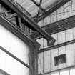
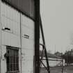
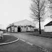
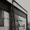
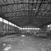
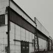
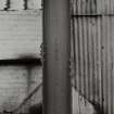
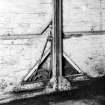
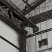
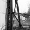
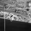
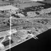
(Location cited as NO 431 309). Stannergate, Dundee. This First World War seaplane base was one of several established by the Royal Naval Air Service along the E coast of Britain for the conduct of reconnaissance and anti-submarine operations. Occupying a 10.1 ha site on the banks of the River Tay, the base was initially equipped with two hangars and a slipway, suitable for serving seaplanes such as the Short 184. The hangars were possibly transferred from an earlier base at Port Laing (NT18SW 106) on the River Forth. By April 1918 a third hangar of more substantial dimensions had been erected, with adjacent slipway, along the E side of the site in order to house the larger Curtiss H-12 and Felixstowe F2A flying boats. This hangar, which can be identified as the tall building in the middle background axial with the slipway, is now all that remains of the original complex.
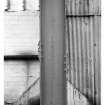
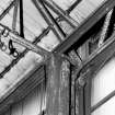
Classified as an F-type hangar, of which two examples built in the 1920's also remain in Scotland at Evanton (NH66NW 34.00) and West Freugh (NX15SW 22), it has a structural frame of all-metal construction set out on a 17ft (5.18m) regular grid. The main area measures 204ft (62.18m) in length by 104ft (31.7m) over a clear roof span, with headroom ('ceiling') of 27ft (8.23m). There is, in addition, a single-storeyed range which extends along the W side. The trusses are of lattice-style construction, and the principal wall-members are made of of U-channel sections and cast with the maker's name 'THE FRODINGHAM IRON & STEEL CO LTD, ENGLAND'.
External, the end-walls are reinforced with raking members, but the main architectural feature of the building is the E wall, which was capable of being opened in sections over its entire length. Framed wheeled doors, each 51ft (15.55m) in width, were manually operated by a crank-and-chain drive. The minimum of fixed supports were used to carry the guide-rails and eaves-girder; these supports comprised latticed stanchions at each end and raking frames at the midpoints, where the girder spanning the double-width central opening is deeper and projects above the eaves-line. Both the roof and walls were clad with corrugated asbestos sheeting of the 'Trafford Tile' pattern, then a relatively new material.
G D Hay and G P Stell 1986.
Publication Account (1986)
The former First World War seaplane base, situated at Stannergate just E of Dundee, was one of several established by the Royal Naval Air Service along the E coast of Britain for conducting reconnaissance and anti-submarine operations. Occupying a 25-acre (10.1 ha) site on the banks of the River Tay, the base was initially equipped with two hangars and a slipway, suitable for serving seaplanes such as the Short 184. The hangars were possibly transferred from an earlier base at Port Laing on the River Forth (NT 134811). By April 1918 a third hangar of more substantial dimensions had been erected, with adjacent slipway, along the E side of the site in order to house the larger Curtiss H-12 and Felixstowe F2A flying-boats. This hangar, which can be identified as the tall building in the middle background axial with the slipway, is now all that remains of the original complex.
Classified as an F-type hangar-of which two later examples built in the 1920s also remain in Scotland at Evanton, Ross and Cromarty, and West Freugh, Wigtownshire, 46-it has a structural frame of all-metal construction set out on a 17ft (5.18m) regular grid. The main area measures 204ft (62.18m) in length by 104ft (31.70m) over a clear roof span, with headroom ('ceiling') of 27ft (8.23m). There is, in addition, a single-storeyed range which extends along the W side. The trusses are of lattice-style construction, and the principal wall-members-cast with the maker's name 'THE FRODINGHAM IRON & STEEL CO LTD, ENGLAND'-are made up of U-channel sections. Externally, the end-walls are reinforced with raking members, but the main architectural feature of the building is the E wall, which was capable of being opened in sections over its entire length. Framed wheeled doors, each 51ft (15.55m) in width, were manually operated by a crank-and-chain drive. The minimum of fixed supports were used to carry the guide-rails and eaves-girder; these supports comprised latticed stanchions at each end and raking frames at the midpoints, where the girder spanning the double-width central opening is deeper and projects above the eaves-line. Both the roof and walls were clad with corrugated asbestos sheeting of the 'Trafford Tile' pattern, then a relatively new material.
Information from ‘Monuments of Industry: An Illustrated Historical Record’ (1986).
Publication Account (1987)
The flying-boat hangar at Stannergate formed part of a World War I seaplane base which continued in operation until the end of World War II. This base was one of many established on the east coast of Scotland for conducting reconnaissance and anti-submarine operations. The base was initially equipped with two hangars (now demolished) possibly transferred from an earlier base at Port Laing (NT 134811).
The surviving hangar was erected by April 1918 to accommodate larger flying-boats such as the Curtiss H-12 and the Felixstowe F2A. It is classified as an F-type hangar and has an all-metal structural frame. The roof trusses are of lattice construction, the principal wall members are of U-channel sections cast with the makers mi.me 'The Frodingham Iron & Steel Co Ltd, England'. The clear-space provided measures 62 m by 32 m with 8.2 m headroom. There is a single-storey projection along the entire length of the west side of the hangar.
Externally, the main architectural feature is the east wall which was capable of being opened in sections over its entire length. Other interesting features include raking members to reinforce the gable structure. Both the roof and walls were clad with 'Trafford Tile' corrugated asbestos sheeting, then a very new material.
Information from ‘Exploring Scotland’s Heritage: Fife and Tayside’, (1987).
Field Visit (2000)
The seaplane base's location falls in an area to the E of Caledon East Wharf. Nothing could be found at this site on the date of visit.
J Guy 2000; NMRS MS 810/9
Note (October 2005)
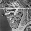
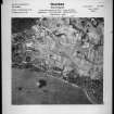
The flying boat (seaplane) base is visible on a series on RAF WW II oblique air photographs (No.1 CAM, AF 686, flown 8 May 1943; NLA66, frame no.26 and 31, flown 2 July 1943; No.1 CAM, 18755, flown 22 October 1943), all of which show the aircraft hangars, sheds, huts and pillbox. Postwar vertical air photography (106G/Scot/UK 55, Pt.II, 5096-5098, flown 8 May 1946), shows the relationship between the seaplane base and the coast battery immediately to the E (NO43SW 162).
All evidence for the base has been removed since the visit made in 1986.
Information from RCAHMS (DE), October 2005
Project (March 2013 - September 2013)
A project to characterise the quantity and quality of the Scottish resource of known surviving remains of the First World War. Carried out in partnership between Historic Scotland and RCAHMS.

