
Scheduled Maintenance
Please be advised that this website will undergo scheduled maintenance on the following dates: •
Tuesday 3rd December 11:00-15:00
During these times, some services may be temporarily unavailable. We apologise for any inconvenience this may cause.
Castle Law, Forgandenny


Bank (Earthwork) (Period Unassigned), Building (Period Unassigned), Fort (Period Unassigned), Roundhouse(S) (Prehistoric), Vitrified Stone (Period Unassigned)
Site Name Castle Law, Forgandenny
Classification Bank (Earthwork) (Period Unassigned), Building (Period Unassigned), Fort (Period Unassigned), Roundhouse(S) (Prehistoric), Vitrified Stone (Period Unassigned)
Alternative Name(s) Culteuchar Hill
Canmore ID 26583
Site Number NO01NE 5
NGR NO 0998 1544
Datum OSGB36 - NGR
Permalink http://canmore.org.uk/site/26583


First 100 images shown. See the Collections panel (below) for a link to all digital images.
- Council Perth And Kinross
- Parish Forgandenny
- Former Region Tayside
- Former District Perth And Kinross
- Former County Perthshire
Falls partly on OS 1:10000 sheet NO11NW
(NO 0998 1544) Castle Law. (NAT) Fort (NR)
OS 6" map, (1959)
Not to be confused with Castle Law, Abernethy (NO11NE 12).
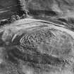
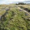
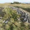
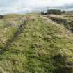
The wall faces in this fort were cleared in 1891 so that it gives a clearer impression than most other timber-laced forts of the character of the defences. The beam sockets were noted by the excavator, but little else was recorded except the plan.
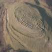
The impression given by the remains is of a rather elaborate design of one period. The summit of the hillock is occupied by an enclosure of 0.2ha, with rounded ends and parallel sides; the wall is about 5.5m thick. Outside this, and separated from it by a space of 8 to 15m, is a further wall, 4.5m thick, now barely visible on the N. The two wall are connected at the E end by a wall which extends both outwards and inwards. There is an entrance to the outer enclosure but no break in the inner wall. This arrangement suggests that the central space was for humans, who could reach it by steps or a moveable ladder; cattle could be protected between the two walls. The axial wall may be compared with that at Finavon (NO55NW 32.00).
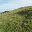
These timber-laced walls form the main fortifications, but there are additional works outside. On the N there is a natural shelf at a lower level; the edge of this, above the steeper hillside, is followed by a low bank. On the S, the hill on which the fort stands is seperated from the higher ground by a depression which carries a small stream in wet weather. The slope between this and the fort is crossed first by a bank with a small ditch on the N, then nearer the fort by a large bank and ditch towards the fort; the arrangements may be compared with Barry Hill (N25SE 23) and the White Caterthun (NO56NW 17).
There is no well visible within the fort, but the depression to the S is crossed by two dams. A similar unusual arrangement is found at Castle Law, Abernethy (NO11NE 12), not far away.
A H A Hogg 1971.
Field Visit (9 October 1957)
Fort, Forgandenny.
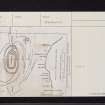
This super fort is matched only by the White Caterthun (NO56NW 17) which it closely resembles, as a type-site for the Gallic wall forts of Angus, Perth and Aberdeen, and it is desirable that a proper plan should be made incorporating all the features shown in the accompanying sketch (Perth TS, 31) some of which are not included in the plan in Proceedings (Christison 1900, 74).
Notable points about the fort area:
a) The situation, which illustrates the Gallic fort builders preference for an isolated eminence affording commanding views in all directions.
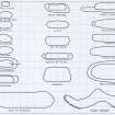
b) The presence on the same site of two timber-laced stone walls (A and B) ; a thinner wall (C) of uncertain width forming as it were an annexe to A and B; massive earthworks (D - F) ; and the terraced seatings of vanished ramp arts (G, H and J).
There seems to be no doubt that the earthworks D - F are coeval with the stone walls, since the same type of earthwork ramparts occur in connection with the Gallic fort on Barry Hill (NO25SE 23), and the quasi –rectangular expansion on the W side i s repeated on the White Caterthun. Wall C and the terraces on the other hand could conceivably belong to an older system of defences, but this point can only be decided by the excavation. My impression is that, as I now believe was the ca se at the White Caterthun, all the visible remains are likely to belong to the same occupational period.
The interior of A has been lacerated by many trenches, but it would still be possible to test, by a relatively small amount of digging, whether the length of inturned wall at the entrance is bonded into or abuts on to the inner wall.
Visited by RCAHMS (KAS) 9 October 1957
Reference (1963)
This fort occupies a slight eminence protruding from the NE flank of Culteuchar Hill 3/4 mile SW of Ecclesiamagirdle on the gloomy N slopes of the Ochils. It was excavated in 1891, when the walls were found to contain the sockets of beams preserved entire; no further details were recorded of this vitally interesting structure. The inner of the two walls encloses an area measuring 180 ft (54.9m) by 80 ft (24.4m), but the plan is confused by the presence of a length of straight wall which pierces the E end of the fort near the entrance and runs through the inner wall for some distance into the centre. In this it recalls to a lesser degree the through wall at Knock Farril (NH55NW 10). Several outworks defend the easiest approach from the hillside to the S.
R W Feachem 1963.
Field Visit (3 August 1965)
Generally as previously described and planned. There is now no visible trace of the sheep fank (Bell 1893) and the site of the watch-tower (Bell 1893) is now occupied by a modern cairn. c 3.0m in diameter. Surveyed at 1:2500
Visited by OS (W D J) 3 August 1965.
Desk Based Assessment (5 February 1965)
(NO 0998 1544) Castle Law. (NAT) Fort (NR)
OS 6" map (1959)
A fort of two concentric walls and extensive outer defences (see plans by Christison and Bell) with 'Abernethy Type' timber-laced ramparts (Cotton 1954) (the defences show evidence of vitrification and beam-holes containing charcoal occur in the inner wall (Bell 1893)). Stewart (information from MEC Stewart to OS, 20 November 1962) and Fairhurst (information from H Fairhurst to MEC Stewart) suggest four possible phases:-
1. A single-walled timber-laced oval fort with an entrance to the east, possibly burnt during the Agricolan campaign.
2. An Iron Age contour fort whose builders added a second rampart with an entrance to the east and who connected these two entrances by a long stone-walled passage way. This fortification was never completed and was possibly interrupted by the campaigns of Septimus Severus.
3. Dark Age- Pictish? fort whose builders added extensive bank and ditch foritifications on the south side and nuclear enclosures to the north and west.
4. In early medieval times the fortified area may have been used as a stock enclosure, with settlement to the south and on the northern scarp.
Bell says that the 'Sheep Fank' shown on his plan was a circular construction of stones, which requires further examination, and that the semi-circular work also shown (in the NE of the interior) was the remains of a watch-tower constructed by one of the late Lords Ruthven of Freeland.
Information from OS (DJC) 5 February 1965.
Sources:
1. OS 6" 1959
2. Cotton 1954
3. Christison 1900
4. Bell 1893
5. Corr. 6" (MEC Stewart 20.11.62)
a. H Fairhurst.
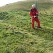
Field Visit (4 December 1995)
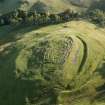
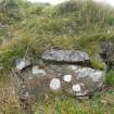
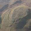
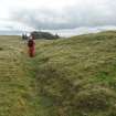
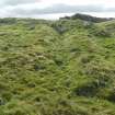
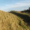
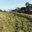
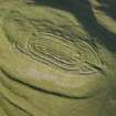
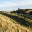
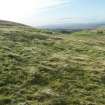
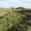
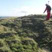
At least ten platforms for timber round-houses are visible within the N part of the fort on Castle Law; they are situated on a terrace enclosed by a grass-grown rampart immediately above the steep slopes protecting the N side of the fort. The platforms measure up to 9m in diameter and the rear portion of two of them are clearly overlain by the outer wall of the timber-laced fort; only the front aprons of the platforms are visible on the N side of the wall. On the NE, the rear scarp (1m high) of another is visible on the S of the wall, but in this case its front is overlain by the wall.
Apart from the house-platforms, a hut-circle is visible on the SE side of the fort, where it overlies the outermost rampart. It measures about 9m in diameter within a grass-grown stony bank up to 2m in thickness and 0.2m in height. No trace of the entrance is visible, but the hut-circle has been disturbed by a modern track. The hut-circle was first identified by Bell as a 'Sheep Fank', but was not located by the OS in 1965.
Visited by RCAHMS (JRS) 4 December 1995.
E W Bell 1893.
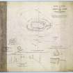
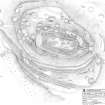
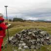
Measured Survey (October 2009 - April 2010)
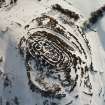
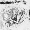
RCAHMS surveyed Castle Law, Forgandenny between October 2009 - April 2010 producing a plan at a scale of 1:1000. Differential GPS was used to survey the site in October 2009 and the resulting linework was used to draw up the plan on-site between 19-20 April 2010. This plan was redrawn in vector graphics software.
Field Visit (April 2010)
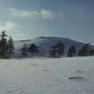
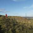
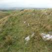
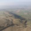
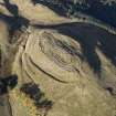
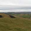
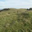
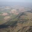
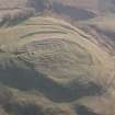
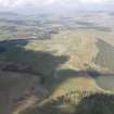
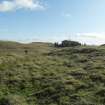
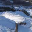
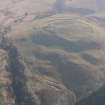
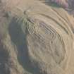
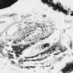
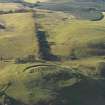
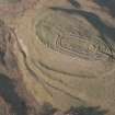
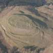
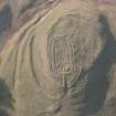
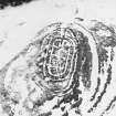
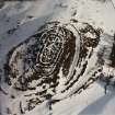
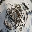
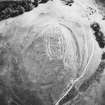
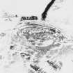
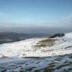
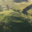
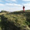
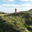
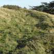
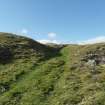
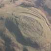
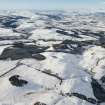
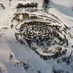
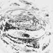
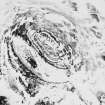
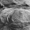
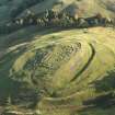
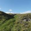
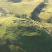
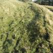
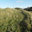
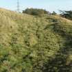
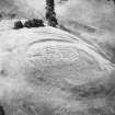
Castle Law is situated on the northern escarpment of the Ochil Hills overlooking Strathearn, and at 280m OD, towers 200m above the valley below, commanding a panoramic view northwards from the NW round to the ENE. The outlook in other directions is less spectacular and the site is overlooked by Culteuchar Hill immediately to the SW. The fort is depicted on the 1st edition of the Ordnance Survey 6-inch-to-a-mile map (Perthshire 1866, sheets CIX & CX) and was mentioned in passing by Christian Maclagan in her volume The Hillforts, Stone Circles and other Structural Remains of Ancient Scotland (1875). In 1892 the fort was subject of an excavation by Edwin Weston Bell, a member of a merchant family and resident of Dundee who bred dogs at nearby Rossie.
Detailed survey of the fort has identified several phases of enclosure punctuated by at least one major period of open settlement, and the final occupation of the hill in prehistory is probably represented by the smaller of the two timber-laced forts on the summit. The excavations by Bell did not recover any diagnostic artefacts and none of the meagre assemblage that he recovered (now in the Royal Museum of Scotland) has a secure context that provides useful dating evidence. Confirmation of the use of the hill in more recent times is restricted to a possible building occupying the interior of a hut-circle on the SE flank of the fort and a degraded bank that overrides rampart 20m upslope from it. Bell also discovered sherds of glazed pottery.
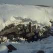
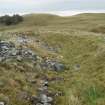
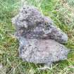
Bell’s account makes it very clear that prior to the excavation the earthworks enclosing the summit of the hill were not particularly prominent. Indeed, he had to guess at the location of the entrance, which he subsequently cleared out, resulting in the large heap of spoil that is now plainly visible below the modern track that approaches from the E. Nevertheless, the excavation succeeded in demonstrating the presence of two separate timber-laced walls, at least one of which, probably the outer, contained the vitrified material that can be found in the scree below, particularly on the S. Bell also discovered two rock-cut post-holes, which appear to represent a period of construction that is earlier than the inner of the two timber-laced walls. Once he had cleared the entrance, the excavation strategy appears to have been to define the inner and outer faces of the two timber-laced walls on the summit, dig trenches and smaller pits in the interior, and test-trench the entrance through a lower line of enclosure on the NW.
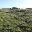
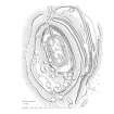
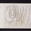
The survey of the fort has identified at least four phases of construction. The earliest seems to be a large enclosure which took in the summit and some of the broad lower terrace on the S, where it is defined by a thick rampart and an external ditch. On the W, this line of defence can be seen climbing obliquely up the slope to disappear under a later rampart, while the northern part of this circuit is entirely lost beneath the outer and earlier of the timber-laced walls. The topographical position of the area enclosed, taking in a steep S-facing slope, is unusual and it is possible that these defences represent the outworks of a summit enclosure that is no longer visible, rather than a freestanding fort.
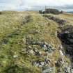
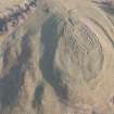
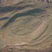
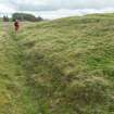
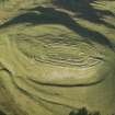
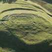
In a subsequent phase the first timber-laced wall was constructed along the line of the natural crest of the summit. Oval on plan, it measures 102m from WNW to ESE by 50m transversely within a wall 4.9m in thickness. This wall has been heavily robbed, but where he dug out the entrance on the E Bell found it standing up to 1.4m high, and it was up to 1.5m high on the SW. The smaller timber-laced fort (59m WNW to ESE by 24m) occupying its interior is certainly later in date and probably represents the last phase of enclosure on the hill. The earlier timber-laced wall, however, had probably been robbed already to construct the rampart of another large enclosure (measuring 42m WNW to ESE by up to 82m) that can be seen extending along the edge of a terrace to the N of the summit and surmounting the ruinous timber-laced wall on the SW. What may be a coeval outer rampart is visible on the W and NW, its line carried by a ragged scarp along the steep N flank of the hill to link with another short length on the E. Both of these ramparts are broken on the NW by an entrance through which a hollowed track-way passes. The terminals of both ramparts here have been flattened to form well-defined platforms for later timber round-houses.
Although Bell did not find a break in the wall of the small timber-laced fort built on the summit, the earlier entrance on the E was almost certainly retained, extending up the slope beside a thick wall that now appears to link the two timber-laced walls. The relationship of this wall to either is unknown and Bell’s trenches appear to trace its line at least 11m into the interior. He conjectured that the entrance may have been set above the level at which he found the innermost wall surviving.
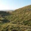
Two other elements of the visible defences do not fit easily into any of these four phases. One is the broad ditch and its external rampart at the foot of the steep S face of the hill. The rampart, now reduced to a thick bank, appears to overlie the rear of several timber house platforms that are cut into the back of the phase 1 rampart immediately to the S, thus indicating a comparatively late date for its construction, possibly as an outwork of the latest timber-laced fort. The second element is the bank that extends along the leading edge of terrace outside this same sector of the phase 1 rampart. Possibly this has formed part of an enclosure taking in a source of water in the gully on the SW of the fort, though it is impossible to disentangle its line from some of the natural features here.
In addition to the defences, Castle Law is exceptional in central Scotland for the forty or so house platforms between 5 and 8m in diameter that can be seen. The best defined of these lie mainly on the terrace to the NW of the summit and on the lower slopes to the NE, but there are also traces of others on the broad terrace on the S. Only the fort on Norman’s Law (NO32SW 22) in Fife, some 21km to the E, provides a ready local comparison, but on Castle Law they clearly represent a major period of open settlement. Thus, while the majority lie within the Phase III fort, some of them on the line of the Phase II wall, others overlie its ramparts. Yet others are cut back into the Phase I rampart on the S, where the settlement appears to sprawl down the surrounding slopes. Few details of the plans of the buildings that stood on these platforms can be discerned without excavation, but in a few cases a slight ledge can be detected on the backscarp. One appears to be a more conventional hut-circle with its wall reduced to a low bank. This structure overlies the Phase I rampart on the SE and was interpreted as a sheep fank by Bell. Its wall is broken by an entrance on the ENE and there are possible traces of a rectangular building occupying its interior.
Information from RCAHMS (JRS) 28 March 2011
Project (16 February 2013 - 22 February 2013)
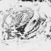
NO 0998 1554 A geophysical survey was carried out at Castle Law (Forgandenny Hillfort) prior to a programme of small-scale excavation. A geophysical survey, using both resistivity and gradiometry techniques, was undertaken 16–22 February 2013. Despite the influence of the underlying geology the data highlighted the variable physical character of the enclosures defining the fort. In particular, the banks appear to have been built using a variety of materials. On the summit of the hill several anomalies, which may be heat affected areas, were identified. Several distinct features were also recorded which appear to correspond to hut platforms recorded by the 2010 RCAHMS survey.
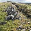
A total of five trenches were excavated, 25 March – 13 April 2013, in order to explore key features of the hillfort. Three trenches explored the massive stone walls of the enclosures on the summit of the hill, which had been previously excavated by the antiquarian Edwin Bell at the end of the 19th century. The stone walls consisted of stone facings with boulder cores. A variety of geological sources provided the material for the walls and distinct segments of construction could be identified. The walls were substantial, measuring >4m wide and the inner enclosure wall survived up to 1.2m high.
The fourth trench was positioned to investigate a possible hut platform and a portion of the bank enclosing the summit of the hill. The results revealed very ephemeral and unstructured traces of occupation within a low bank of chipped stone. The enclosing bank was composed of a core of possible metalworking debris and burnt bone, sealed by a stone cap.
The fifth trench examined an outer bank on the S side of the hill. The bank was largely composed of a mix of earth and stone, which had been excavated from an outer ditch. Thin lenses of burnt twigs and vegetation were recorded near the top of the bank.
Archive: University of Glasgow and RCAHMS (intended)
Funder: Historic Scotland, University of Glasgow
Tessa Poller, University of Glasgow, 2013
(Source: DES)
Resistivity (16 February 2013 - 22 February 2013)
NO 0998 1554 Resistivity survey.
Archive: University of Glasgow and RCAHMS (intended)
Funder: Historic Scotland, University of Glasgow
Tessa Poller, University of Glasgow, 2013
(Source: DES)
Magnetometry (16 February 2013 - 22 February 2013)
NO 0998 1554 Magnetometry survey.
Archive: University of Glasgow and RCAHMS (intended)
Funder: Historic Scotland, University of Glasgow
Tessa Poller, University of Glasgow, 2013
(Source: DES)
Note (30 April 2015 - 13 October 2016)
A complex fort occupies the summit of Castle Law above Forgandenny, commanding wide views across the lower reaches of Strath Earn. The sequence of construction is not fully understood, and the remains on the ground are confused by the wall-chasing excavation trenches left open following the excavations by Edwin Weston Bell in 1892 (Bell 1893). Indeed, the more recent excavations of Tessa Poller 2013-14, have shown that the sequence proposed by a RCAHMS survey in 2010 cannot be sustained, and with hindsight the remains were over-interpreted in an attempt to make sense of the various complete and partial circuits of walls and ramparts that are visible. Four principal elements can be distinguished: an elongated, sub-rectangular enclosure with a massive timber-laced wall on the summit; a surrounding oval enclosure with a substantial wall, principally visible on the E, S and W, but apparently largely obliterated on the N; a larger enclosure formed by a rampart that also takes in a lower terrace on the NW of the summit, and was possibly accompanied by an outer rampart around most of the circuit; and finally at least three lines of ramparts and ditches at the foot of the slope facing into the saddle connecting the hill to the main mass of Culteuchar Hill, none of which can be demonstrated as either annexes or outworks to the other circuits. In addition a thick bank drops down to the edge of the Deich Burn on the E, while another on the W terminates just above the outflow from the boggy sump that occupies the bottom of the saddle on the SW. The sub-rectangular enclosure on the summit measure 59m from ESE to WNW by 24m transversely (0.12ha) within a wall that Poller's excavations have shown to be some 5.5m in thickness and in some places still standing 1.4m in height; taking into account the quantities of fallen masonry, this wall was probably once well in excess of 3m high. The oval enclosure outside it measures 102m from ESE to WNW by 50m transversely (0.39ha) within what was probably another timber-laced wall up to 4.9m in thickness; whereas no gap has been located in the innermost enclosure, Bell uncovered an entrance into the oval enclosure on the ESE, where the S terminal of the wall turns sharply back into the interior and has been shown by Poller to butt onto the wall of the innermost enclosure. At face value this relationship suggests the oval enclosure is secondary, but its wall on the N seems to have been virtually obliterated before the collapse of the innermost wall in this sector, perhaps suggesting a more complex sequence of robbing and replacement, and a subsequent reconstruction of the earlier line on the E to enhance the approach to the inner enclosure; in character the wall linking the two circuits has more in common with the wing-walls on Knock Farril in Easter Ross (Atlas No.2888) than any known entrance architecture. The survey of 2010 suggested that the oval enclosure was also overlain in the S sector by the rampart of a much larger fort measuring 142m from NW to SE by a maximum of 82m transversely (0.93ha), though the junction was confused by Bell's trenches and the apparent relationship in which some of the numerous house-platforms within its interior overlay the wall of the oval enclosure does not appear so secure in the light of Poller's excavations. These tested one of the platforms on the N, which was found to be no more than an irregularity in the deep deposits of collapsed rubble from the innermost wall. A more likely sequence might put this fort earlier than the two enclosures on the summit, though where tested on the SW its rampart also appeared to have been burnt and was accompanied by an external ditch. Possibly accompanied by a second rampart out side it, there were entrances on the ESE and WNW, and at the latter the terminals of the outer rampart are overlain by circular platforms. The relationships between any of these circuits and the outerworks on the more easily accessible slope facing onto the saddle on the S remain unknown, though the W end of the inner of them, with a broad ditch and an external rampart appears to overlie scoops to the rear of the rampart outside it; this latter may have been conceived as some form of annexe bringing access to the water in the boggy sump in the saddle within the compass of the defences. On the SE this outer line is overlain by what is probably a hut-circle, the interior of which is occupied by rectangular building; several other hut-circles lie on the slope below the defences on the NNE.
Information from An Atlas of Hillforts of Great Britain and Ireland – 13 October 2016. Atlas of Hillforts SC2994

